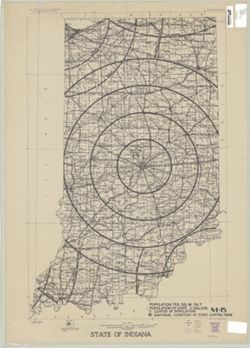
Topical Subject: National cemeteries and Geographic Subject: Indiana
Publisher:
[U.S. War Dept.?]
Date Created:
1940
Identifier:
VAC3073-M-00333
Genre:
Thematic maps
Geographic Location:
Coordinates: W0880700 W0844500 N0414500 N0375200
Related URL:
Catalog URL: https://iucat.iu.edu/catalog/5177103
Abstract:
Shows proposed National Cemetery in Indianapolis with 25 mile concentric rings showing distance from the proposed National Cemetery and other National Cemete...
Call Number:
G4091.G54 1940 .S73
Caption:
Imprint: [Washington, D.C.? : U.S. War Dept.?, 194-?]

![Dubois County [Indiana] land use map : preliminary](https://iiif.uits.iu.edu/iiif/2/n583zx450%2Ffiles%2F8319c249-85b5-442f-8ac2-cef230e85e51/full/250,/0/default.jpg)
![Vanderburgh County [Indiana] preliminary land use map](https://iiif.uits.iu.edu/iiif/2/qf85pf475%2Ffiles%2F018f45ab-c6b4-40b1-9e75-dc08e8ae02ae/full/250,/0/default.jpg)
![Putnam County [Indiana] land use map : preliminary](https://iiif.uits.iu.edu/iiif/2/ff3669524%2Ffiles%2Fa99c639f-fb69-43c3-a158-8bffb65d6978/full/250,/0/default.jpg)
![Jefferson County [Indiana] preliminary land use map](https://iiif.uits.iu.edu/iiif/2/2f75sc94w%2Ffiles%2F7a98897d-f193-46e6-9bdf-a873b1f3fc06/full/250,/0/default.jpg)
![Orange County [Indiana] preliminary land use map](https://iiif.uits.iu.edu/iiif/2/9p291f25v%2Ffiles%2Ffa8d35ba-54cc-4d4f-bc44-58833d93e051/full/250,/0/default.jpg)
![Fayette County [Indiana] preliminary land use map](https://iiif.uits.iu.edu/iiif/2/xk81kq192%2Ffiles%2F166701bf-144d-4037-bd2c-0e915f8f7b76/full/250,/0/default.jpg)
![Warrick County [Indiana] land use map : preliminary](https://iiif.uits.iu.edu/iiif/2/1z40mw11c%2Ffiles%2Fdf0b1772-63ad-4eb7-a01c-aa6b48eaa924/full/250,/0/default.jpg)
![Ohio County [Indiana] preliminary land use map](https://iiif.uits.iu.edu/iiif/2/r494wn92n%2Ffiles%2F1c94efdb-0aa0-4604-ab15-ea52383eb128/full/250,/0/default.jpg)