
Search Constraints
You searched for:
Country
СССР (USSR)
Remove constraint Country: СССР (USSR)
Date Created
1933
Remove constraint Date Created: 1933
« Previous |
1 - 20 of 26
|
Next »
Search Results
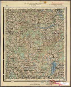
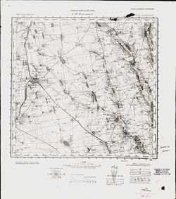
-
- Description:
- 1929
- Subject:
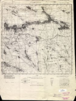
- Topical Subject: Maps, Topical Subject: Soviet Union, and Geographic Subject: Kopatkevichi
- Publisher:
- Генеральный штаб РККА
- Language:
- Russian
- Date Created:
- 1933
- Identifier:
- VAC9619-004143
- Genre:
- Topographic Maps and Military Maps
- Geographic Location:
- Coordinates: 52, 28.5, 52.333, 29
- Related URL:
- Download GeoTIFF: https://drive.google.com/file/d/1vFmkpV4uQzJmBBUY9p8FqhxDZL8iaKel/view?usp=sharing and Catalog URL: https://iucat.iu.edu/catalog/5020129
- Abstract:
- Modern area represented: Kopatkevichi, Homyel oblast, Belarus
- Call Number:
- G7000 s100 .S7 sheet N-35-142
- Caption:
- Не подлежит оглашению
- City:
- Копаткевичи (Kopatkevichi)
- Copyright Holder:
- No Copyright - United States
- Country:
- СССР (USSR)
- State/Province:
- Белорусская ССР (Byelorussian Soviet Socialist Republic)
- Physical Description:
- Scale: 1:100,000
- Persistent URL:
- http://purl.dlib.indiana.edu/iudl/images/VAC9619/VAC9619-004143
- Provenance:
- DMA Topographic Center, Army Map Service Library, OMAHA
-
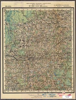
- Description:
- 1908
- Subject:
- Geographic Subject: Ivenets, Topical Subject: Maps, and Topical Subject: Soviet Union
- Publisher:
- Управление военных топографов РККА
- Language:
- Russian
- Date Created:
- 1933
- Identifier:
- VAC9619-004078
- Genre:
- Topographic Maps and Military Maps
- Geographic Location:
- Coordinates: 53.667, 26.5, 54, 27
- Related URL:
- Catalog URL: https://iucat.iu.edu/catalog/5020129 and Download GeoTIFF: https://drive.google.com/file/d/17IBW-4Qy8vDRjL3XAe46WFA6YEoc1hsn/view?usp=sharing
- Abstract:
- Modern area represented: Ivenets, Belarus
- Call Number:
- G7000 s100 .S7 sheet N-35-78
- Caption:
- Не подлежит оглашению
- City:
- Ивенец (Ivenets)
- Copyright Holder:
- No Copyright - United States
- Country:
- Польша (Poland) and СССР (USSR)
- State/Province:
- Белорусская ССР (Byelorussian Soviet Socialist Republic)
- Physical Description:
- Scale: 1:100,000
- Persistent URL:
- http://purl.dlib.indiana.edu/iudl/images/VAC9619/VAC9619-004078
- Provenance:
- DMA Topographic Center, Army Map Service Library, OMAHA
-
- Description:
- 1908
- Subject:
- Topical Subject: Soviet Union, Topical Subject: Maps, and Geographic Subject: Dzyarzhynsk
- Publisher:
- Генеральный штаб РККА
- Language:
- Russian
- Date Created:
- 1933
- Identifier:
- VAC9619-004079
- Genre:
- Military Maps and Topographic Maps
- Geographic Location:
- Coordinates: 53.667, 27, 54, 27.5
- Related URL:
- Catalog URL: https://iucat.iu.edu/catalog/5020129 and Download GeoTIFF: https://drive.google.com/file/d/1tjboYSTp1DC-Rdz2djVaRt-RniRow98d/view?usp=sharing
- Abstract:
- Modern area represented: Dzyarzhynsk, Belarus
- Call Number:
- G7000 s100 .S7 sheet N-35-79
- Caption:
- Не подлежит оглашению
- City:
- Дзержинск (Dzyarzhynsk)
- Copyright Holder:
- No Copyright - United States
- Country:
- Польша (Poland) and СССР (USSR)
- State/Province:
- Белорусская ССР (Byelorussian Soviet Socialist Republic)
- Physical Description:
- Scale: 1:100,000
- Persistent URL:
- http://purl.dlib.indiana.edu/iudl/images/VAC9619/VAC9619-004079
- Provenance:
- DMA Topographic Center, Army Map Service Library, OMAHA
-
- Description:
- 1926
- Subject:
- Topical Subject: Soviet Union, Topical Subject: Maps, and Geographic Subject: Zhizhitsa
- Publisher:
- Управление военных топографов
- Language:
- Russian
- Date Created:
- 1933
- Identifier:
- VAC9619-003490
- Genre:
- Topographic Maps and Military Maps
- Geographic Location:
- Coordinates: 56.167, 31.25, 56.333, 31.5
- Related URL:
- Download GeoTIFF: https://drive.google.com/file/d/1akHjhCoHjwS7M9NoqxD_Wge8T9N5pm0n/view?usp=sharing and Catalog URL: http://iucat.iu.edu/catalog/5020131
- Abstract:
- Modern area represented: Жижица (Zhizhitsa), Pskovskaya oblast, Russia
- Call Number:
- G7000 s50 .S68 sheet O-36-135-B
- Caption:
- Captured map and Не подлежит оглашению
- City:
- Жижица (Zhizhitsa)
- Copyright Holder:
- No Copyright - United States
- Country:
- СССР (USSR)
- State/Province:
- Западная область (Western oblast) and РСФСР (RSFSR)
- Physical Description:
- Scale: 1:50,000
- Persistent URL:
- http://purl.dlib.indiana.edu/iudl/images/VAC9619/VAC9619-003490
- Provenance:
- DMA Topographic Center, Army Map Service Library, OMAHA, Library of Congress Geography & Map Division
-
- Description:
- 1926
- Subject:
- Geographic Subject: Vysokoye, Topical Subject: Maps, and Topical Subject: Soviet Union
- Publisher:
- Управление военных топографов
- Language:
- Russian
- Date Created:
- 1933
- Identifier:
- VAC9619-003462
- Genre:
- Topographic Maps and Military Maps
- Geographic Location:
- Coordinates: 56.333, 31.25, 56.5, 31.5
- Related URL:
- Download GeoTIFF: https://drive.google.com/file/d/1tidCd1WzQh7iMs7Mrr31FLldj-CyVjKl/view?usp=sharing and Catalog URL: http://iucat.iu.edu/catalog/5020131
- Abstract:
- Modern area represented: Высокое (Vysokoye), Tverskaya oblast, Russia
- Call Number:
- GM G7000 s50 .S68 sheet O-36-123-D
- Caption:
- Не подлежит оглашению
- City:
- Лошаеды (Loshayedy)
- Copyright Holder:
- No Copyright - United States
- Country:
- СССР (USSR)
- State/Province:
- Западная область (Western oblast) and РСФСР (RSFSR)
- Physical Description:
- Scale: 1:50,000
- Persistent URL:
- http://purl.dlib.indiana.edu/iudl/images/VAC9619/VAC9619-003462
- Provenance:
- M. I. Map Library, Library of Congress Geography & Map Division
-
- Subject:
- Geographic Subject: Sheykino, Topical Subject: Soviet Union, and Topical Subject: Maps
- Publisher:
- Управление военных топографов
- Language:
- Russian
- Date Created:
- 1933
- Identifier:
- VAC9619-003461
- Genre:
- Topographic Maps and Military Maps
- Geographic Location:
- Coordinates: 56.333, 31, 56.5, 31.25
- Related URL:
- Catalog URL: http://iucat.iu.edu/catalog/5020131 and Download GeoTIFF: https://drive.google.com/file/d/1fjd216-PEi63ervxn65sPkj51GMPE7fJ/view?usp=sharing
- Abstract:
- Modern area represented: Шейкино (Sheykino), Pskovskaya oblast, Russia
- Call Number:
- GM G7000 s50 .S68 sheet O-36-123-C
- Caption:
- Не подлежит оглашению
- City:
- Шейкино (Sheykino)
- Copyright Holder:
- No Copyright - United States
- Country:
- СССР (USSR)
- State/Province:
- РСФСР (RSFSR) and Западная область (Western oblast)
- Physical Description:
- Scale: 1:50,000
- Persistent URL:
- http://purl.dlib.indiana.edu/iudl/images/VAC9619/VAC9619-003461
- Provenance:
- M. I. Map Library, Justus Perthes Kartensammlung
-
- Description:
- 1910
- Subject:
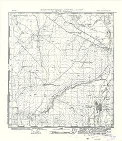
- Geographic Subject: Sharhorod, Topical Subject: Soviet Union, and Topical Subject: Maps
- Publisher:
- Генеральный штаб Красной Армии
- Language:
- Russian
- Date Created:
- 1933
- Identifier:
- VAC9619-003243
- Genre:
- Topographic Maps and Military Maps
- Geographic Location:
- Coordinates: 48.667, 28, 49, 28.5
- Related URL:
- Catalog URL: https://iucat.iu.edu/catalog/5020129 and Download GeoTIFF: https://drive.google.com/file/d/1eXbG8jlG1VAmkShBED_fiZOoPN31kXP8/view?usp=sharing
- Abstract:
- Modern area represented: Sharhorod, Vinnytsia oblast, Ukraine
- Call Number:
- G7000 s100 .S7 sheet M-35-117
- Caption:
- Для служебного пользования
- City:
- Шаргород (Sharhorod)
- Copyright Holder:
- No Copyright - United States
- Country:
- СССР (USSR)
- State/Province:
- Украинская ССР (Ukrainian Soviet Socialist Republic) and Винницкая область (Vinnytsia oblast)
- Physical Description:
- Scale: 1:100,000
- Persistent URL:
- http://purl.dlib.indiana.edu/iudl/images/VAC9619/VAC9619-003243
- Provenance:
- DMA Topographic Center, Army Map Service Library, OMAHA, Library of Congress Geography & Map Division
-
- Description:
- 1932
- Subject:
- Geographic Subject: Ovruch, Topical Subject: Soviet Union, and Topical Subject: Maps
- Publisher:
- Генеральный штаб РККА
- Language:
- Russian
- Date Created:
- 1933
- Identifier:
- VAC9619-003112
- Genre:
- Military Maps and Topographic Maps
- Geographic Location:
- Coordinates: 51, 28.5, 51.333, 29
- Related URL:
- Catalog URL: https://iucat.iu.edu/catalog/5020129 and Download GeoTIFF: https://drive.google.com/file/d/1Ux4iL3wR3fHhjgZHVXpIrMLVmUdCl5KE/view?usp=sharing
- Abstract:
- Modern area represented: Ovruch, Ukraine
- Call Number:
- G7000 s100 .S7 sheet M-35-34
- Caption:
- Не подлежит оглашению
- City:
- Овруч (Ovruch)
- Copyright Holder:
- No Copyright - United States
- Country:
- СССР (USSR)
- State/Province:
- Украинская ССР (Ukrainian Soviet Socialist Republic) and Житомирская область (Zhytomyr oblast)
- Physical Description:
- Scale: 1:100,000
- Persistent URL:
- http://purl.dlib.indiana.edu/iudl/images/VAC9619/VAC9619-003112
- Provenance:
- DMA Topographic Center, Army Map Service Library, OMAHA, Library of Congress Geography & Map Division
-
- Description:
- 1913
- Subject:
- Topical Subject: Maps, Geographic Subject: Korosten, and Topical Subject: Soviet Union
- Publisher:
- Управление военных топографов РККА
- Language:
- Russian
- Date Created:
- 1933
- Identifier:
- VAC9619-003119
- Genre:
- Military Maps and Topographic Maps
- Geographic Location:
- Coordinates: 50.667, 28.5, 51, 29
- Related URL:
- Catalog URL: https://iucat.iu.edu/catalog/5020129 and Download GeoTIFF: https://drive.google.com/file/d/1r4KaIwlzKRcnmPHpmBYXDKSMN0LMEF56/view?usp=sharing
- Abstract:
- Modern area represented: Korosten, Zhytomyr oblast, Ukraine
- Call Number:
- G7000 s100 .S7 sheet M-35-46
- Caption:
- Не подлежит оглашению
- City:
- Коростень (Korosten)
- Copyright Holder:
- No Copyright - United States
- Country:
- СССР (USSR)
- State/Province:
- Украинская ССР (Ukrainian Soviet Socialist Republic) and Киевская область (Kyiv oblast)
- Physical Description:
- Scale: 1:100,000
- Persistent URL:
- http://purl.dlib.indiana.edu/iudl/images/VAC9619/VAC9619-003119
- Provenance:
- DMA Topographic Center, Army Map Service Library, OMAHA
-
- Description:
- 1913
- Subject:
- Geographic Subject: Ivankiv, Topical Subject: Soviet Union, and Topical Subject: Maps
- Publisher:
- Управление военных топографов РККА
- Language:
- Russian
- Date Created:
- 1933
- Identifier:
- VAC9619-003120
- Genre:
- Topographic Maps and Military Maps
- Geographic Location:
- Coordinates: 50.667, 29.5, 51, 30
- Related URL:
- Download GeoTIFF: https://drive.google.com/file/d/1Ra_HooqAngw0iRatiTrefjd7SIFeN4au/view?usp=sharing and Catalog URL: https://iucat.iu.edu/catalog/5020129
- Abstract:
- Modern area represented: Ivankiv, Kiev oblast, Ukraine
- Call Number:
- G7000 s100 .S7 sheet M-35-48
- Caption:
- Не подлежит оглашению
- City:
- Иванков (Ivankiv)
- Copyright Holder:
- No Copyright - United States
- Country:
- СССР (USSR)
- State/Province:
- Киевская область (Kyiv oblast) and Украинская ССР (Ukrainian Soviet Socialist Republic)
- Physical Description:
- Scale: 1:100,000
- Persistent URL:
- http://purl.dlib.indiana.edu/iudl/images/VAC9619/VAC9619-003120
- Provenance:
- DMA Topographic Center, Army Map Service Library, OMAHA
-
- Description:
- 1913
- Subject:
- Topical Subject: Soviet Union, Topical Subject: Maps, and Geographic Subject: Makariv
- Publisher:
- Управление военных топографов РККА
- Language:
- Russian
- Date Created:
- 1933
- Identifier:
- VAC9619-003123
- Genre:
- Topographic Maps and Military Maps
- Geographic Location:
- Coordinates: 50.333, 29.5, 50.667, 30
- Related URL:
- Catalog URL: https://iucat.iu.edu/catalog/5020129 and Download GeoTIFF: https://drive.google.com/file/d/13LZmOOndyLlk6oJu1Lq5Rp9sPNueEMsP/view?usp=sharing
- Abstract:
- Modern area represented: Makariv, Kiev oblast, Ukraine
- Call Number:
- G7000 s100 .S7 sheet M-35-60
- Caption:
- Не подлежит оглашению
- City:
- Макаров (Makariv)
- Copyright Holder:
- No Copyright - United States
- Country:
- СССР (USSR)
- State/Province:
- Киевская область (Kyiv oblast) and Украинская ССР (Ukrainian Soviet Socialist Republic)
- Physical Description:
- Scale: 1:100,000
- Persistent URL:
- http://purl.dlib.indiana.edu/iudl/images/VAC9619/VAC9619-003123
- Provenance:
- DMA Topographic Center, Army Map Service Library, OMAHA, Library of Congress Geography & Map Division
-
- Description:
- 1929
- Subject:
- Topical Subject: Soviet Union, Topical Subject: Maps, and Geographic Subject: Rozdilna
- Publisher:
- Генеральный штаб РККА
- Language:
- Russian
- Date Created:
- 1933
- Identifier:
- VAC9619-001880
- Genre:
- Topographic Maps and Military Maps
- Geographic Location:
- Coordinates: 46.6667, 30, 47, 30.5
- Related URL:
- Download GeoTIFF: https://drive.google.com/open?id=1UoKPXAXBoUbctkfHhw7v09vU6GsKNUFp and Catalog URL: https://iucat.iu.edu/catalog/5020129
- Abstract:
- Modern area represented: Rozdilna, Odessa oblast, Ukraine
- Call Number:
- G7000 s100 .S7 sheet L-36-37
- Caption:
- Не подлежит оглашению
- City:
- Пос. Раздельная (Posad Pazdelnaya)
- Copyright Holder:
- No Copyright - United States
- Country:
- СССР (USSR)
- State/Province:
- Молдавская АССР (Moldavian Autonomous Soviet Socialist Republic) and Одесская область (Odessa oblast)
- Physical Description:
- Scale: 1:100,000
- Persistent URL:
- http://purl.dlib.indiana.edu/iudl/images/VAC9619/VAC9619-001880
- Provenance:
- CIA Map Library
-
- Description:
- 1929
- Subject:
- Geographic Subject: Petrovirivka, Topical Subject: Maps, and Topical Subject: Soviet Union
- Publisher:
- Управление военных топографов РККА
- Language:
- Russian
- Date Created:
- 1933
- Identifier:
- VAC9619-001872
- Genre:
- Military Maps and Topographic Maps
- Geographic Location:
- Coordinates: 47, 30, 47.3333, 30.5
- Related URL:
- Catalog URL: https://iucat.iu.edu/catalog/5020129 and Download GeoTIFF: https://drive.google.com/open?id=1Yp0PmoQ_FhFSY9xYe9Mdj5WFZQ1lZ9L8
- Abstract:
- Modern area represented: Petrovirivka, Odessa oblast, Ukraine
- Call Number:
- G7000 s100 .S7 sheet L-36-25
- Caption:
- Не подлежит оглашению
- City:
- Жовтнево (Zhovtnevo)
- Copyright Holder:
- No Copyright - United States
- Country:
- СССР (USSR)
- State/Province:
- Одесская область (Odessa oblast) and Украинская ССР (Ukrainian Soviet Socialist Republic)
- Physical Description:
- Scale: 1:100,000
- Persistent URL:
- http://purl.dlib.indiana.edu/iudl/images/VAC9619/VAC9619-001872
- Provenance:
- DMA Topographic Center, Atlasblatt, Library of Congress Geography & Map Division, Army Map Service Library
-
- Description:
- 1927
- Subject:
- Topical Subject: Soviet Union, Topical Subject: Maps, and Geographic Subject: Kryve Ozero
- Publisher:
- Генеральный штаб РККА
- Language:
- Russian
- Date Created:
- 1933
- Identifier:
- VAC9619-001860
- Genre:
- Topographic Maps and Military Maps
- Geographic Location:
- Coordinates: 47.6667, 30, 48, 30.5
- Related URL:
- Catalog URL: https://iucat.iu.edu/catalog/5020129 and Download GeoTIFF: https://drive.google.com/open?id=1hbij6lPaIDBZ6sv_u07NP2w2I0N9ow8M
- Abstract:
- Modern area represented: Kryve Ozero, Mykolaiv oblast, Ukraine
- Call Number:
- G7000 s100 .S7 sheet L-36-1
- Caption:
- Не подлежит оглашению
- City:
- Кривое Озеро (Kryve Ozero)
- Copyright Holder:
- No Copyright - United States
- Country:
- СССР (USSR)
- State/Province:
- Украинская ССР (Ukrainian Soviet Socialist Republic), Одесская область (Odessa oblast), and Молдавская АССР (Moldavian Autonomous Soviet Socialist Republic)
- Physical Description:
- Scale: 1:100,000
- Persistent URL:
- http://purl.dlib.indiana.edu/iudl/images/VAC9619/VAC9619-001860
- Provenance:
- CIA Map Library, Atlasblatt
-
- Description:
- 1931
- Subject:
- Topical Subject: Maps, Geographic Subject: Zhidilovka, and Topical Subject: Soviet Union
- Publisher:
- Главное Управление Геодезии и Картографии при СНК СССР
- Language:
- Russian
- Date Created:
- 1933
- Identifier:
- VAC9619-001656
- Genre:
- Topographic Maps and Military Maps
- Geographic Location:
- Coordinates: 52.5, 52.25, 52.667, 52.5
- Related URL:
- Catalog URL: http://iucat.iu.edu/catalog/5020131 and Download GeoTIFF: https://drive.google.com/open?id=1HNPlbss41O64cg3X6XTm_EwuMiWCCZsX
- Abstract:
- Modern area represented: Zhidilovka, Orenburg oblast, Russia
- Call Number:
- G7000 s50 .S68 sheet N-39-129-B
- City:
- Жидиловка (Zhidilovka)
- Copyright Holder:
- No Copyright - United States
- Country:
- СССР (USSR)
- State/Province:
- РСФСР (RSFSR) and Чкаловская область (Chkalov oblast)
- Physical Description:
- Scale: 1:50,000
- Persistent URL:
- http://purl.dlib.indiana.edu/iudl/images/VAC9619/VAC9619-001656
- Provenance:
- CIA Map Library
-
- Description:
- 1906
- Subject:
- Geographic Subject: Hunchun, Topical Subject: Soviet Union, and Topical Subject: Maps
- Publisher:
- Управление военных топографов РККА
- Language:
- Russian
- Date Created:
- 1933
- Identifier:
- VAC9619-000914
- Genre:
- Topographic Maps and Military Maps
- Geographic Location:
- Coordinates: 42.6667, 130, 43, 130.5
- Related URL:
- Download GeoTIFF: https://drive.google.com/open?id=14YXbAZgngEEXJeyyh0_6PJ45RyfdxAgg and Catalog URL: https://iucat.iu.edu/catalog/5020129
- Abstract:
- Modern area represented: Hunchun, Jilin province, China
- Call Number:
- G7000 s100 .S7 sheet K-52-45
- Caption:
- Не подлежит оглашению
- City:
- Хунчун (Hunchun)
- Copyright Holder:
- No Copyright - United States
- Country:
- СССР (USSR) and Корея (Korea)
- State/Province:
- Дальневосточный край (Far Eastern kray), Маньчжурия (Manchuria), and РСФСР (RSFSR)
- Physical Description:
- Scale: 1:100,000
- Persistent URL:
- http://purl.dlib.indiana.edu/iudl/images/VAC9619/VAC9619-000914
- Provenance:
- DMA Topographic Center, Army Map Service Library, OMAHA, Library of Congress Geography & Map Division
-
- Description:
- 1908
- Subject:
- Topical Subject: Soviet Union, Topical Subject: Maps, and Geographic Subject: Ракаў (Rakaw)
- Publisher:
- Управление военных топографов РККА
- Language:
- Russian
- Date Created:
- 1933
- Identifier:
- VAC9619-000616
- Genre:
- Topographic Maps and Military Maps
- Geographic Location:
- Coordinates: 53.833, 27, 54, 27.25
- Related URL:
- Catalog URL: http://iucat.iu.edu/catalog/5020131 and Download GeoTIFF: https://drive.google.com/open?id=18Y_zd5QAI_bgmrQq90bC_d6C_jJQYQd3
- Abstract:
- Modern area represented: Rakaw, Minsk oblast, Belarus
- Call Number:
- G7000 s50 .S68 sheet N-35-79-A
- Caption:
- Не подлежит оглашению
- City:
- Ракув (Raków)
- Copyright Holder:
- No Copyright - United States
- Country:
- СССР (USSR) and Польша (Poland)
- State/Province:
- Белорусская ССР (Byelorussian Soviet Socialist Republic)
- Physical Description:
- Scale: 1:50,000
- Persistent URL:
- http://purl.dlib.indiana.edu/iudl/images/VAC9619/VAC9619-000616
- Provenance:
- M. I. Map Library, G000-30, GS, RA
-
- Description:
- 1908
- Subject:
- Topical Subject: Maps, Geographic Subject: Волма (Volma), and Topical Subject: Soviet Union
- Publisher:
- Управление военных топографов РККА
- Language:
- Russian
- Date Created:
- 1933
- Identifier:
- VAC9619-000613
- Genre:
- Military Maps and Topographic Maps
- Geographic Location:
- Coordinates: 53.833, 26.75, 54, 27
- Related URL:
- Catalog URL: http://iucat.iu.edu/catalog/5020131 and Download GeoTIFF: https://drive.google.com/open?id=1tJbyl0CQWseddDO75ISYRQUXDEkA9On0
- Abstract:
- Modern area represented: Volma, Minsk oblast, Belarus
- Call Number:
- G7000 s50 .S68 sheet N-35-78-B
- Caption:
- Не подлежит оглашению
- City:
- Волма (Volma)
- Copyright Holder:
- No Copyright - United States
- Country:
- СССР (USSR) and Польша (Poland)
- State/Province:
- Белорусская ССР (Byelorussian Soviet Socialist Republic)
- Physical Description:
- Scale: 1:50,000
- Persistent URL:
- http://purl.dlib.indiana.edu/iudl/images/VAC9619/VAC9619-000613
- Provenance:
- M. I. Map Library, G000-30, GS, RA
-
- Description:
- 1921
- Subject:
- Topical Subject: Soviet Union, Topical Subject: Maps, and Geographic Subject: Великі Копані (Velyki Kopani)
- Publisher:
- Управление военных топографов
- Language:
- Russian
- Date Created:
- 1933
- Identifier:
- VAC9619-000122
- Genre:
- Military Maps and Topographic Maps
- Geographic Location:
- Coordinates: 46.3333, 32.75, 46.5, 33
- Related URL:
- https://drive.google.com/open?id=1YVaxNwv9dRB21t0pKObSeHn__dPVCw7l, Download GeoTIFF: https://drive.google.com/open?id=1PpCBrQtUKhwRBcPpZgQf3aNkYSHRD9F5, and...
- Abstract:
- Modern area represented: Velyki Kopani, Kherson oblast, Ukraine
- Call Number:
- G7000 s50 .S68 sheet L-36-54-D
- Caption:
- Не подлежит оглашению,Секретно
- City:
- Большие Копани (Bolshiye Kopani)
- Copyright Holder:
- No Copyright - United States
- Country:
- СССР (USSR)
- State/Province:
- Украинская ССР (Ukrainian Soviet Socialist Republic)
- Physical Description:
- Scale: 1:50,000
- Persistent URL:
- http://purl.dlib.indiana.edu/iudl/images/VAC9619/VAC9619-000122
- Provenance:
- DMA Topographic Center, Army Map Service Library, OMAHA
-
- Description:
- 1930
- Subject:
- Geographic Subject: Kachkarivka, Topical Subject: Soviet Union, and Topical Subject: Maps
- Publisher:
- Управление военных топографов
- Language:
- Russian
- Date Created:
- 1933
- Identifier:
- VAC9619-000109
- Genre:
- Military Maps and Topographic Maps
- Geographic Location:
- Coordinates: 47, 33.5, 47.1667, 33.75
- Related URL:
- https://drive.google.com/open?id=1W43g9MiU8xvPdVcAWPMDiWnj5AHoRdgg, Catalog URL: http://iucat.iu.edu/catalog/5020131, and Download GeoTIFF: https://drive.goo...
- Abstract:
- Modern area represented: Kachkarivka, Kherson oblast, Ukraine
- Call Number:
- G7000 s50 .S68 sheet L-36-32-C
- Caption:
- Не подлежит оглашению
- City:
- Качкаровка (Kachkarovka)
- Copyright Holder:
- No Copyright - United States
- Country:
- СССР (USSR)
- State/Province:
- Украинская ССР (Ukrainian Soviet Socialist Republic)
- Physical Description:
- Scale: 1:50,000
- Persistent URL:
- http://purl.dlib.indiana.edu/iudl/images/VAC9619/VAC9619-000109
- Provenance:
- DMA Topographic Center, Army Map Service Library, Library of Congress Geography & Map Division
