
Search Constraints
You searched for:
Date Created
1931
Remove constraint Date Created: 1931
Publisher
Управление военных топографов РККА
Remove constraint Publisher: Управление военных топографов РККА
1 - 5 of 5
Search Results
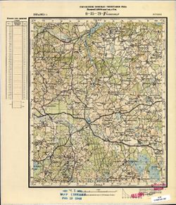
-

- Description:
- 1930
- Subject:
- Topical Subject: Soviet Union, Topical Subject: Maps, and Geographic Subject: Volodarsk
- Publisher:
- Управление военных топографов РККА
- Language:
- Russian
- Date Created:
- 1931
- Identifier:
- VAC9619-001550
- Genre:
- Military Maps and Topographic Maps
- Geographic Location:
- Coordinates: 52.3333, 30, 52.5, 30.25
- Related URL:
- Catalog URL: http://iucat.iu.edu/catalog/5020131 and Download GeoTIFF: https://drive.google.com/open?id=14iHQXU-g8T1RMvt81Kvfrqde3lXKwkh5
- Abstract:
- Modern area represented: Volodarsk, Homyel oblast, Belarus
- Call Number:
- G7000 s50 .S68 sheet N-36-121-C
- Caption:
- Не подлежит оглашению
- City:
- Гавеновичи (Gavenovichi)
- Copyright Holder:
- No Copyright - United States
- Country:
- СССР (USSR)
- State/Province:
- Белорусская ССР (Byelorussian Soviet Socialist Republic)
- Physical Description:
- Scale: 1:50,000
- Persistent URL:
- http://purl.dlib.indiana.edu/iudl/images/VAC9619/VAC9619-001550
- Provenance:
- Army Map Service Library, Library of Congress Geography & Map Division, OMAHA
-
- Description:
- 1929
- Subject:
- Topical Subject: Soviet Union, Geographic Subject: Yelsk, and Topical Subject: Maps
- Publisher:
- Управление военных топографов РККА
- Language:
- Russian
- Date Created:
- 1931
- Identifier:
- VAC9619-003048
- Genre:
- Topographic Maps and Military Maps
- Geographic Location:
- Coordinates: 51.667, 29, 52, 29.5
- Related URL:
- Download GeoTIFF: https://drive.google.com/file/d/1ly2jIDqmS_8iOt2QwCBH2oYCvLx95adN/view?usp=sharing and Catalog URL: https://iucat.iu.edu/catalog/5020129
- Abstract:
- Modern area represented: Yelsk, Gomel oblast, Belarus
- Call Number:
- G7000 s100 .S7 sheet M-35-11
- Caption:
- Не подлежит оглашению
- City:
- Ельск (Yelsk)
- Copyright Holder:
- No Copyright - United States
- Country:
- СССР (USSR)
- State/Province:
- Белорусская ССР (Byelorussian Soviet Socialist Republic)
- Physical Description:
- Scale: 1:100,000
- Persistent URL:
- http://purl.dlib.indiana.edu/iudl/images/VAC9619/VAC9619-003048
- Provenance:
- DMA Topographic Center, Army Map Service Library, OMAHA, Library of Congress Geography & Map Division
-
- Description:
- 1925
- Subject:
- Topical Subject: Soviet Union, Topical Subject: Maps, and Geographic Subject: Vysotsko
- Publisher:
- Управление военных топографов РККА
- Language:
- Russian
- Date Created:
- 1931
- Identifier:
- VAC9619-002808
- Genre:
- Military Maps and Topographic Maps
- Geographic Location:
- Coordinates: 57.667, 28.75, 57.833, 29
- Related URL:
- Catalog URL: http://iucat.iu.edu/catalog/5020131 and Download GeoTIFF: https://drive.google.com/file/d/1XeSJwqOf9Ci2fYuXX1uBAYFobIcATAhj/view?usp=sharing
- Abstract:
- Modern area represented: Высоцко (Vysotsko), Псковская область (Pskovskaya oblast), Russia
- Call Number:
- GM G7000 s50 .S68 sheet O-35-82-D
- Caption:
- Не подлежит оглашению
- City:
- Высоцкая (Vysotsko)
- Copyright Holder:
- No Copyright - United States
- Country:
- СССР (USSR)
- State/Province:
- Ленинградская область (Leningrad oblast) and РСФСР (RSFSR)
- Physical Description:
- Scale: 1:50,000
- Persistent URL:
- http://purl.dlib.indiana.edu/iudl/images/VAC9619/VAC9619-002808
- Provenance:
- M. I. Map Library, Reichsamt für Landesaufnahme, Kartensammlung
-
- Subject:
- Topical Subject: Soviet Union, Topical Subject: Maps, and Geographic Subject: Obinitsa
- Publisher:
- Управление военных топографов РККА
- Language:
- Russian
- Date Created:
- 1931
- Identifier:
- VAC9619-002793
- Genre:
- Military Maps and Topographic Maps
- Geographic Location:
- Coordinates: 57.667, 27.25, 57.833, 27.5
- Related URL:
- Download GeoTIFF: https://drive.google.com/file/d/14CwXMAiUIJxYbCQ9XkEg5ZKN1CgZvip2/view?usp=sharing and Catalog URL: http://iucat.iu.edu/catalog/5020131
- Abstract:
- Modern area represented: Обинитса (Obinitsa), Estonia
- Call Number:
- GM G7000 s50 .S68 sheet O-35-79-D
- City:
- Авинчище (Avinchishche)
- Copyright Holder:
- No Copyright - United States
- Country:
- Эстония (Estonia)
- Physical Description:
- Scale: 1:50,000
- Persistent URL:
- http://purl.dlib.indiana.edu/iudl/images/VAC9619/VAC9619-002793
- Provenance:
- M. I. Map Library
-

- Description:
- 1899
- Subject:
- Geographic Subject: Lėnas, Topical Subject: Maps, and Topical Subject: Soviet Union
- Publisher:
- Управление военных топографов РККА
- Language:
- Russian
- Date Created:
- 1931
- Identifier:
- VAC9619-000438
- Genre:
- Military Maps and Topographic Maps
- Geographic Location:
- Coordinates: 55.3333, 24.5, 55.5, 24.75
- Related URL:
- Catalog URL: http://iucat.iu.edu/catalog/5020131 and Download GeoTIFF: https://drive.google.com/open?id=11BV0OHjrniSQcx8fwYAJo-MUKrQZYsm2
- Abstract:
- Modern area represented: Lėnas, Lithuania
- Call Number:
- G7000 s50 .S68 sheet N-35-14-C
- City:
- Ланы (Lany)
- Copyright Holder:
- No Copyright - United States
- Country:
- Литва (Lithuania)
- Physical Description:
- Scale: 1:50,000
- Persistent URL:
- http://purl.dlib.indiana.edu/iudl/images/VAC9619/VAC9619-000438
- Provenance:
- Army Map Service Library, OMAHA, Library of Congress Geography & Map Division
