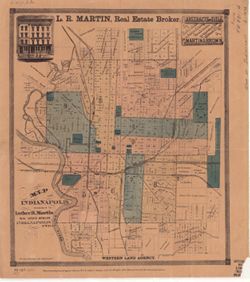
Geographic Subject: Marion County (Ind.), Topical Subject: Railroads, Geographic Subject: Indianapolis (Ind.), and Topical Subject: Administrative and politi...
Creator:
Martin, Luther R.
Publisher:
Martin, Luther R.
Date Created:
1870
Identifier:
VAC3073-M-00327
Genre:
Thematic maps
Geographic Location:
Coordinates: W0861941 W0855614 N0395538 N0393755
Related URL:
Catalog URL: https://iucat.iu.edu/catalog/7186112
Abstract:
Includes names of railroad lines. Shows boundaries for nine sections of town.
Call Number:
G4094.I4 1870 .M37
Caption:
Imprint: Indianapolis, Ind. : Luther R. Martin, 1870.
Physical Description:
Dimensions: 34 x 29 cm, on sheet 37 x 33 cm and Scale: Scale not given.
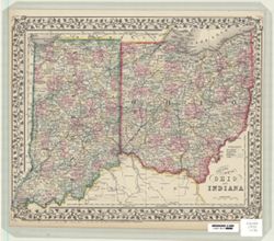
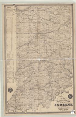
Topical Subject: Administrative and political divisions and Geographic Subject: Indiana
Creator:
H.H. Lloyd & Co.
Publisher:
H.H. Lloyd & Co.
Date Created:
1870
Identifier:
VAC3073-M-00039
Genre:
Thematic maps
Geographic Location:
Coordinates: W0880700 W0844500 N0414500 N0375200
Related URL:
Catalog URL: https://iucat.iu.edu/catalog/4662974
Abstract:
Shows sections, townships, counties, populated places, railroads, and canals. Includes inset showing railroads from Lawrenceburg, Ind. to Cincinnati, charts ...


![[Chambers Family]](/assets/work-ff055336041c3f7d310ad69109eda4a887b16ec501f35afc0a547c4adb97ee72.png)
![[there is no ledger entry for this image]](https://iiif.uits.iu.edu/iiif/2/c821hc43x%2Ffiles%2Fc986b785-e56d-4847-983d-ca7cef92e137/full/250,/0/default.jpg)