
Search Constraints
You searched for:
Publisher
Главное управление геодезии и картографии при СНК СССР
Remove constraint Publisher: Главное управление геодезии и картографии при СНК СССР
Search Results
-
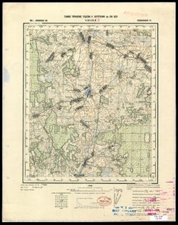
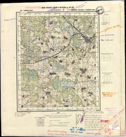
- Description:
- 1938
- Subject:
- Topical Subject: Soviet Union, Geographic Subject: Demyansk, and Topical Subject: Maps
- Publisher:
- Главное управление геодезии и картографии при СНК СССР
- Language:
- Russian
- Date Created:
- 1941
- Identifier:
- VAC9619-002186
- Genre:
- Topographic Maps and Military Maps
- Geographic Location:
- Coordinates: 57.3333, 32, 57.6667, 32.5
- Related URL:
- Catalog URL: https://iucat.iu.edu/catalog/5020129 and Download GeoTIFF: https://drive.google.com/open?id=1BZn8_6UHOHxS9rXqkXT9DxmFIAG4rdVd
- Abstract:
- Modern area represented: Демянск (Demyansk), Novgorodskaya oblast, Russia
- Call Number:
- G7000 s100 .S7 sheet O-36-89
- Caption:
- Для служебного пользования
- City:
- Демянск (Demyansk)
- Copyright Holder:
- No Copyright - United States
- Country:
- СССР (USSR)
- State/Province:
- Ленинградская область (Leningrad oblast) and РСФСР (RSFSR)
- Physical Description:
- Scale: 1:100,000
- Persistent URL:
- http://purl.dlib.indiana.edu/iudl/images/VAC9619/VAC9619-002186
- Provenance:
- DMA Topographic Center, Army Map Service Library, OMAHA, Library of Congress Geography & Map Division
-
- Description:
- 1939
- Subject:
- Topical Subject: Soviet Union, Topical Subject: Maps, and Geographic Subject: Ostrov
- Publisher:
- Главное управление геодезии и картографии при СНК СССР
- Language:
- Russian
- Date Created:
- 1941
- Identifier:
- VAC9619-002957
- Genre:
- Military Maps and Topographic Maps
- Geographic Location:
- Coordinates: 60, 31.75, 60.167, 32
- Related URL:
- Catalog URL: http://iucat.iu.edu/catalog/5020131 and Download GeoTIFF: https://drive.google.com/file/d/17pBS93leK5HdBIyVCAHPECmK_QwD68KD/view?usp=sharing
- Abstract:
- Modern area represented: Ostrov, Russia
- Call Number:
- GM G7000 s50 .S68 sheet P-36-136-D
- Caption:
- Для служебного пользования
- City:
- Остров (Ostrov)
- Copyright Holder:
- No Copyright - United States
- Country:
- СССР (USSR)
- State/Province:
- Волховский район (Volkhov district), Мгинский район (Mginsky district), РСФСР (RSFSR), and Ленинградская область (Leningrad oblast)
- Physical Description:
- Scale: 1:50,000
- Persistent URL:
- http://purl.dlib.indiana.edu/iudl/images/VAC9619/VAC9619-002957
- Provenance:
- DMA Topographic Center, Army Map Service Library, OMAHA, Library of Congress Geography & Map Division
-
- Description:
- 1939
- Subject:
- Topical Subject: Soviet Union, Topical Subject: Maps, and Geographic Subject: Sopkovo
- Publisher:
- Главное управление геодезии и картографии при СНК СССР
- Language:
- Russian
- Date Created:
- 1941
- Identifier:
- VAC9619-002844
- Genre:
- Topographic Maps and Military Maps
- Geographic Location:
- Coordinates: 57, 33.75, 57.167, 34
- Related URL:
- Catalog URL: http://iucat.iu.edu/catalog/5020131 and Download GeoTIFF: https://drive.google.com/file/d/18FH-llDMmXXbl0gZPsN4umcqhipvl5E2/view?usp=sharing
- Abstract:
- Modern area represented: Сопково (Sopkovo), Тверская область (Tverskaya oblast), Russia
- Call Number:
- GM G7000 s50 .S68 sheet O-36-104-D
- Caption:
- Для служебного пользования
- City:
- Сапково (Sapkovo)
- Copyright Holder:
- No Copyright - United States
- Country:
- СССР (USSR)
- State/Province:
- Калининская область (Kalinin oblast), Каменский район (Kamensky district), Есеновичский район (Yesenovichsky district), Кировский район (Kirov district), and...
- Physical Description:
- Scale: 1:50,000
- Persistent URL:
- http://purl.dlib.indiana.edu/iudl/images/VAC9619/VAC9619-002844
- Provenance:
- DMA Topographic Center, Army Map Service Library, OMAHA, Library of Congress Geography & Map Division
-
- Description:
- 1935
- Subject:
- Geographic Subject: Beloomut, Topical Subject: Soviet Union, and Topical Subject: Maps
- Publisher:
- Главное управление геодезии и картографии при СНК СССР
- Language:
- Russian
- Date Created:
- 1941
- Identifier:
- VAC9619-003104
- Genre:
- Topographic Maps and Military Maps
- Geographic Location:
- Coordinates: 54.667, 39.5, 55, 40
- Related URL:
- Catalog URL: https://iucat.iu.edu/catalog/5020129 and Download GeoTIFF: https://drive.google.com/file/d/1ytSBhHkK0h6zsHI_yGAVMdzh18II2O-T/view?usp=sharing
- Abstract:
- Modern area represented: Beloomut, Russia
- Call Number:
- G7000 s100 .S7 sheet N-37-43
- Caption:
- Для служебного пользования
- City:
- Белоомут (Beloomut)
- Copyright Holder:
- No Copyright - United States
- Country:
- СССР (USSR)
- State/Province:
- РСФСР (RSFSR), Московская область (Moscow oblast), and Рязанская область (Ryazan oblast)
- Physical Description:
- Scale: 1:100,000
- Persistent URL:
- http://purl.dlib.indiana.edu/iudl/images/VAC9619/VAC9619-003104
- Provenance:
- DMA Topographic Center, Army Map Service Library, Geographic Names Branch
-
- Description:
- 1939
- Subject:
- Geographic Subject: Shishkovo, Topical Subject: Soviet Union, and Topical Subject: Maps
- Publisher:
- Главное управление геодезии и картографии при СНК СССР
- Language:
- Russian
- Date Created:
- 1941
- Identifier:
- VAC9619-002187
- Genre:
- Military Maps and Topographic Maps
- Geographic Location:
- Coordinates: 57.3333, 32.5, 57.6667, 33
- Related URL:
- Download GeoTIFF: https://drive.google.com/open?id=1t9eliFe23sv-tiuF09y-YiGhMD-CSu9x and Catalog URL: https://iucat.iu.edu/catalog/5020129
- Abstract:
- Modern area represented: Шишково (Shishkovo), Novgorodskaya oblast, Russia
- Call Number:
- G7000 s100 .S7 sheet O-36-90
- Caption:
- Для служебного пользования
- City:
- Шишково (Shishkovo)
- Copyright Holder:
- No Copyright - United States
- Country:
- СССР (USSR)
- State/Province:
- Калининская область (Kalinin oblast), РСФСР (RSFSR), and Ленинградская область (Leningrad oblast)
- Physical Description:
- Scale: 1:100,000
- Persistent URL:
- http://purl.dlib.indiana.edu/iudl/images/VAC9619/VAC9619-002187
- Provenance:
- DMA Topographic Center, Army Map Service Library, OMAHA, Library of Congress Geography & Map Division
-
- Description:
- 1938
- Subject:
- Topical Subject: Maps, Geographic Subject: Pavlikovo, and Topical Subject: Soviet Union
- Publisher:
- Главное управление геодезии и картографии при СНК СССР
- Language:
- Russian
- Date Created:
- 1941
- Identifier:
- VAC9619-003472
- Genre:
- Topographic Maps and Military Maps
- Geographic Location:
- Coordinates: 56.5, 34.25, 56.667, 34.5
- Related URL:
- Download GeoTIFF: https://drive.google.com/file/d/1cM86uH12YBkYFhQNZjwCtN7j02FCIzUX/view?usp=sharing and Catalog URL: http://iucat.iu.edu/catalog/5020131
- Abstract:
- Modern area represented: Павликово (Pavlikovo), Tverskaya oblast, Russia
- Call Number:
- G7000 s50 .S68 sheet O-36-129-B
- City:
- Павликово (Pavlikovo)
- Copyright Holder:
- No Copyright - United States
- Country:
- СССР (USSR)
- State/Province:
- Луковниковский район (Lukovnikovsky district) and Калининская область (Kalinin oblast)
- Physical Description:
- Scale: 1:50,000
- Persistent URL:
- http://purl.dlib.indiana.edu/iudl/images/VAC9619/VAC9619-003472
- Provenance:
- M. I. Map Library, Library of Congress Geography & Map Division
-
- Description:
- 1936
- Subject:
- Topical Subject: Soviet Union, Geographic Subject: Rogovskaya, and Topical Subject: Maps
- Publisher:
- Главное управление геодезии и картографии при СНК СССР
- Language:
- Russian
- Date Created:
- 1940
- Identifier:
- VAC9619-002338
- Genre:
- Topographic Maps and Military Maps
- Geographic Location:
- Coordinates: 45.667, 38.5, 46, 39
- Related URL:
- Download GeoTIFF: https://drive.google.com/file/d/1Z_my8K4ECfFywgELXq5ypJAneao9d9kI/view?usp=sharing and Catalog URL: https://iucat.iu.edu/catalog/5020129
- Abstract:
- Modern area represented: Rogovskaya, Russia
- Call Number:
- G7000 s100 .S7 sheet L-37-78
- Caption:
- Для служебного пользования
- City:
- Станица Роговская (Stanitsa Rogovskaya)
- Copyright Holder:
- No Copyright - United States
- Country:
- СССР (USSR)
- State/Province:
- РСФСР (RSFSR) and Краснодарский край (Krasnodar kray)
- Physical Description:
- Scale: 1:100,000
- Persistent URL:
- http://purl.dlib.indiana.edu/iudl/images/VAC9619/VAC9619-002338
- Provenance:
- Army Map Service Library
-
- Description:
- 1939
- Subject:
- Topical Subject: Soviet Union, Geographic Subject: Shuya, and Topical Subject: Maps
- Publisher:
- Главное управление геодезии и картографии при СНК СССР
- Language:
- Russian
- Date Created:
- 1941
- Identifier:
- VAC9619-002151
- Genre:
- Topographic Maps and Military Maps
- Geographic Location:
- Coordinates: 58, 33, 58.3333, 33.5
- Related URL:
- Catalog URL: https://iucat.iu.edu/catalog/5020129 and Download GeoTIFF: https://drive.google.com/open?id=12B3cJ_5IrjQRm_PXq7FKNN4Nd9o_O4NM
- Abstract:
- Modern area represented: Шуя (Shuya), Novgorodskaya oblast, Russia
- Call Number:
- G7000 s100 .S7 sheet O-36-67
- Caption:
- Captured map and Для служебного пользования
- City:
- Шуя (Shuya)
- Copyright Holder:
- No Copyright - United States
- Country:
- СССР (USSR)
- State/Province:
- РСФСР (RSFSR) and Ленинградская область (Leningrad oblast)
- Physical Description:
- Scale: 1:100,000
- Persistent URL:
- http://purl.dlib.indiana.edu/iudl/images/VAC9619/VAC9619-002151
- Provenance:
- DMA Topographic Center, Army Map Service Library, OMAHA, Library of Congress Geography & Map Division
-
- Description:
- 1938
- Subject:
- Geographic Subject: Likhoslavl', Topical Subject: Soviet Union, and Topical Subject: Maps
- Publisher:
- Главное управление геодезии и картографии при СНК СССР
- Language:
- Russian
- Date Created:
- 1941
- Identifier:
- VAC9619-002852
- Genre:
- Military Maps and Topographic Maps
- Geographic Location:
- Coordinates: 57, 35.25, 57.167, 35.5
- Related URL:
- Download GeoTIFF: https://drive.google.com/file/d/1_1d7nZrOWqXaKo7w86AM92cd9KGEpK5Y/view?usp=sharing and Catalog URL: http://iucat.iu.edu/catalog/5020131
- Abstract:
- Modern area represented: Лихославль (Likhoslavl'), Тверская область (Tverskaya oblast), Russia
- Call Number:
- GM G7000 s50 .S68 sheet O-36-107-D
- City:
- Лихославль (Likhoslavl')
- Copyright Holder:
- No Copyright - United States
- Country:
- СССР (USSR)
- State/Province:
- Новоторжский район (Novotorzhsky district), Лихославльский район (Likhoslavlsky district), Калининская область (Kalinin oblast), and Медновский район (Mednov...
- Physical Description:
- Scale: 1:50,000
- Persistent URL:
- http://purl.dlib.indiana.edu/iudl/images/VAC9619/VAC9619-002852
- Provenance:
- M. I. Map Library
-
- Description:
- 1939
- Subject:
- Geographic Subject: Dudino, Topical Subject: Maps, and Topical Subject: Soviet Union
- Publisher:
- Главное управление геодезии и картографии при СНК СССР
- Language:
- Russian
- Identifier:
- VAC9619-002889
- Genre:
- Military Maps and Topographic Maps
- Geographic Location:
- Coordinates: 56.667, 32, 56.833, 32.25
- Related URL:
- Download GeoTIFF: https://drive.google.com/file/d/1Py3jDGm2QyjkNIWE8MgDv-5TtIaWklTa/view?usp=sharing and Catalog URL: http://iucat.iu.edu/catalog/5020131
- Abstract:
- Modern area represented: Дудино (Dudino), Tverskaya oblast, Russia
- Call Number:
- GM G7000 s50 .S68 sheet O-36-113-C
- Caption:
- Captured map and Для служебного пользования
- City:
- Дудино (Dudino)
- Copyright Holder:
- No Copyright - United States
- Country:
- СССР (USSR)
- State/Province:
- Калининская область (Kalinin oblast), Ленинский район (Leninsky district), and Пеновский район (Penovsky district)
- Physical Description:
- Scale: 1:50,000
- Persistent URL:
- http://purl.dlib.indiana.edu/iudl/images/VAC9619/VAC9619-002889
- Provenance:
- Army Map Service Library, OMAHA, Library of Congress Geography & Map Division
