
Search Constraints
You searched for:
Date Created
1942
Remove constraint Date Created: 1942
State/Province
Украинская ССР (Ukrainian Soviet Socialist Republic)
Remove constraint State/Province: Украинская ССР (Ukrainian Soviet Socialist Republic)
1 - 45 of 45
Search Results
-
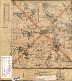
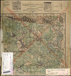
- Description:
- 1930
- Subject:
- Topical Subject: Maps, Topical Subject: Soviet Union, and Geographic Subject: Velyka Lepetykha
- Publisher:
- Генеральный штаб Красной Армии
- Language:
- Russian
- Date Created:
- 1942
- Identifier:
- VAC9619-001876
- Genre:
- Topographic Maps and Military Maps
- Geographic Location:
- Coordinates: 47, 33.5, 47.3333, 34
- Related URL:
- Catalog URL: https://iucat.iu.edu/catalog/5020129 and Download GeoTIFF: https://drive.google.com/open?id=1KEO4HekmlEItJ6LWmCEklRcW04fJsr0O
- Abstract:
- Modern area represented: Velyka Lepetykha, Kherson oblast, Ukraine
- Call Number:
- G7000 s100 .S7 sheet L-36-32
- Caption:
- Для служебного пользования
- City:
- Бол. Лепатиха (Bolshaya Lepatikha)
- Copyright Holder:
- No Copyright - United States
- Country:
- СССР (USSR)
- State/Province:
- Украинская ССР (Ukrainian Soviet Socialist Republic)
- Physical Description:
- Scale: 1:100,000
- Persistent URL:
- http://purl.dlib.indiana.edu/iudl/images/VAC9619/VAC9619-001876
- Provenance:
- DMA Topographic Center, Army Map Service Library, Library of Congress Geography & Map Division
-
- Description:
- 1931
- Subject:
- Topical Subject: Maps, Geographic Subject: Donetsk, Geographic Subject: Kalmiuske, and Topical Subject: Soviet Union
- Publisher:
- Генеральный штаб Красной Армии
- Language:
- Russian
- Date Created:
- 1942
- Identifier:
- VAC9619-002004
- Genre:
- Topographic Maps and Military Maps
- Geographic Location:
- Coordinates: 47.3333, 39, 47.6667, 39.5
- Related URL:
- Download GeoTIFF: https://drive.google.com/open?id=1NZxwosLYVa9EAJO1rvzTEoZMt-K31pfv and Catalog URL: https://iucat.iu.edu/catalog/5020129
- Abstract:
- Modern area represented: Кальміуське (Kalmiuske), Donetsk, Ukraine
- Call Number:
- G7000 s100 .S7 sheet L-37-17
- Caption:
- Для cлужебного пользования
- City:
- Каракубстрой (Karakubstroy)
- Copyright Holder:
- No Copyright - United States
- Country:
- СССР (USSR)
- State/Province:
- Украинская ССР (Ukrainian Soviet Socialist Republic), Сталинская область (Stalino oblast), Ростовская область (Rostov oblast), and РСФСР (RSFSR)
- Physical Description:
- Scale: 1:100,000
- Persistent URL:
- http://purl.dlib.indiana.edu/iudl/images/VAC9619/VAC9619-002004
- Provenance:
- DMA Topographic Center, Army Map Service Library, OMAHA
-
- Subject:
- Topical Subject: Maps, Topical Subject: Soviet Union, and Geographic Subject: Novi Sanzhary
- Publisher:
- Генеральный штаб Красной Армии
- Language:
- Russian
- Date Created:
- 1942
- Identifier:
- VAC9619-001042
- Genre:
- Military Maps and Topographic Maps
- Geographic Location:
- Coordinates: 49.3333, 34.25, 49.5, 34.5
- Related URL:
- Download GeoTIFF: https://drive.google.com/open?id=1dSVe_KHHuw0RagCOmihgtm__ZT7JFBUf and Catalog URL: http://iucat.iu.edu/catalog/5020131
- Abstract:
- Modern area represented: Novi Sanzhary, Poltava oblast, Ukraine
- Call Number:
- G7000 s50 .S68 sheet M-36-93-D
- Caption:
- Для служебного пользования
- City:
- Новые Сенжары (Novye Senzhary)
- Copyright Holder:
- No Copyright - United States
- Country:
- СССР (USSR)
- State/Province:
- Украинская ССР (Ukrainian Soviet Socialist Republic) and Полтавская область (Poltava oblast)
- Physical Description:
- Scale: 1:50,000
- Persistent URL:
- http://purl.dlib.indiana.edu/iudl/images/VAC9619/VAC9619-001042
- Provenance:
- DMA Topographic Center, Army Map Service Library, OMAHA, Library of Congress Geography & Map Division
-
- Subject:
- Topical Subject: Maps, Topical Subject: Soviet Union, and Geographic Subject: Mashivka
- Publisher:
- Генеральный штаб Красной Армии
- Language:
- Russian
- Date Created:
- 1942
- Identifier:
- VAC9619-001046
- Genre:
- Military Maps and Topographic Maps
- Geographic Location:
- Coordinates: 49.3333, 34.75, 49.5, 35
- Related URL:
- Download GeoTIFF: https://drive.google.com/open?id=1i-uHI6R1mMnFbnpYUSaDwJ1FBl5QSEwF and Catalog URL: http://iucat.iu.edu/catalog/5020131
- Abstract:
- Modern area represented: Машівка (Mashivka), Poltava oblast, Ukraine
- Call Number:
- G7000 s50 .S68 sheet M-36-90-D
- Caption:
- Для служебного пользования
- City:
- Машевка (Mashevka)
- Copyright Holder:
- No Copyright - United States
- Country:
- СССР (USSR)
- State/Province:
- Украинская ССР (Ukrainian Soviet Socialist Republic) and Полтавская область (Poltava oblast)
- Physical Description:
- Scale: 1:50,000
- Persistent URL:
- http://purl.dlib.indiana.edu/iudl/images/VAC9619/VAC9619-001046
- Provenance:
- DMA Topographic Center, Army Map Service Library, OMAHA, Library of Congress Geography & Map Division
-
- Description:
- 1941
- Subject:
- Geographic Subject: Starovirivka, Topical Subject: Maps, and Topical Subject: Soviet Union
- Publisher:
- Генеральный штаб Красной Армии
- Language:
- Russian
- Date Created:
- 1942
- Identifier:
- VAC9619-001048
- Genre:
- Military Maps and Topographic Maps
- Geographic Location:
- Coordinates: 49.5, 35.5, 49.6667, 35.75
- Related URL:
- Catalog URL: http://iucat.iu.edu/catalog/5020131 and Download GeoTIFF: https://drive.google.com/open?id=1epkymOh-z8QLb51mw2YoiN9UQy5BPi81
- Abstract:
- Modern area represented: Старовірівка (Starovirivka), Kharkiv oblast, Ukraine
- Call Number:
- G7000 s50 .S68 sheet M-36-96-A
- Caption:
- Для служебного пользования
- City:
- Староверовка (Staroverovka)
- Copyright Holder:
- No Copyright - United States
- Country:
- СССР (USSR)
- State/Province:
- Украинская ССР (Ukrainian Soviet Socialist Republic) and Харьковская область (Kharkiv oblast)
- Physical Description:
- Scale: 1:50,000
- Persistent URL:
- http://purl.dlib.indiana.edu/iudl/images/VAC9619/VAC9619-001048
- Provenance:
- DMA Topographic Center, Army Map Service Library, OMAHA, Library of Congress Geography & Map Division
-
- Description:
- 1941
- Subject:
- Topical Subject: Maps, Geographic Subject: Krasnohrad, and Topical Subject: Soviet Union
- Publisher:
- Генеральный штаб Красной Армии
- Language:
- Russian
- Date Created:
- 1942
- Identifier:
- VAC9619-001047
- Genre:
- Military Maps and Topographic Maps
- Geographic Location:
- Coordinates: 49.3333, 35.25, 49.5, 35.5
- Related URL:
- Download GeoTIFF: https://drive.google.com/open?id=14EVkiGEa0yFekMGdqYL1VRalK5RWYaZC and Catalog URL: http://iucat.iu.edu/catalog/5020131
- Abstract:
- Modern area represented: Красноград (Krasnohrad), Kharkiv oblast, Ukraine
- Call Number:
- G7000 s50 .S68 sheet M-36-95-D
- Caption:
- Для служебного пользования
- City:
- Красноград (Krasnograd)
- Copyright Holder:
- No Copyright - United States
- Country:
- СССР (USSR)
- State/Province:
- Полтавская область (Poltava oblast), Украинская ССР (Ukrainian Soviet Socialist Republic), and Харьковская область (Kharkiv oblast)
- Physical Description:
- Scale: 1:50,000
- Persistent URL:
- http://purl.dlib.indiana.edu/iudl/images/VAC9619/VAC9619-001047
- Provenance:
- DMA Topographic Center, Army Map Service Library, OMAHA, Library of Congress Geography & Map Division
-
- Subject:
- Topical Subject: Soviet Union, Topical Subject: Maps, and Geographic Subject: Melykhivka
- Publisher:
- Генеральный штаб Красной Армии
- Language:
- Russian
- Date Created:
- 1942
- Identifier:
- VAC9619-001049
- Genre:
- Topographic Maps and Military Maps
- Geographic Location:
- Coordinates: 49.5, 35.75, 49.6667, 36
- Related URL:
- Catalog URL: http://iucat.iu.edu/catalog/5020131 and Download GeoTIFF: https://drive.google.com/open?id=1U_njyIztDh7j4OtSpiutyC0dRp8k4dO7
- Abstract:
- Modern area represented: Мелихівка (Melykhivka), Kharkiv oblast, Ukraine
- Call Number:
- G7000 s50 .S68 sheet M-36-96-B
- Caption:
- Для служебного пользования
- City:
- Мелиховка (Melihovka)
- Copyright Holder:
- No Copyright - United States
- Country:
- СССР (USSR)
- State/Province:
- Украинская ССР (Ukrainian Soviet Socialist Republic) and Харьковская область (Kharkiv oblast)
- Physical Description:
- Scale: 1:50,000
- Persistent URL:
- http://purl.dlib.indiana.edu/iudl/images/VAC9619/VAC9619-001049
- Provenance:
- DMA Topographic Center, Army Map Service Library, OMAHA, Library of Congress Geography & Map Division
-
- Description:
- 1941
- Subject:
- Topical Subject: Maps, Geographic Subject: Berestoven'ka, and Topical Subject: Soviet Union
- Publisher:
- Генеральный штаб Красной Армии
- Language:
- Russian
- Date Created:
- 1942
- Identifier:
- VAC9619-001050
- Genre:
- Military Maps and Topographic Maps
- Geographic Location:
- Coordinates: 49.3333, 35.5, 49.5, 35.75
- Related URL:
- Catalog URL: http://iucat.iu.edu/catalog/5020131 and Download GeoTIFF: https://drive.google.com/open?id=1RLSdGY0_GrzBYsmtvle-MCO1uyYsp5dK
- Abstract:
- Modern area represented: Берестовенька (Berestoven'ka), Kharkiv oblast, Ukraine
- Call Number:
- G7000 s50 .S68 sheet M-36-96-C
- Caption:
- Для служебного пользования
- City:
- Берестовенька (Berestoven'ka)
- Copyright Holder:
- No Copyright - United States
- Country:
- СССР (USSR)
- State/Province:
- Харьковская область (Kharkiv oblast) and Украинская ССР (Ukrainian Soviet Socialist Republic)
- Physical Description:
- Scale: 1:50,000
- Persistent URL:
- http://purl.dlib.indiana.edu/iudl/images/VAC9619/VAC9619-001050
- Provenance:
- DMA Topographic Center, Army Map Service Library, OMAHA, Library of Congress Geography & Map Division
-
- Subject:
- Topical Subject: Soviet Union, Topical Subject: Maps, and Geographic Subject: Shlyakhove
- Publisher:
- Генеральный штаб Красной Армии
- Language:
- Russian
- Date Created:
- 1942
- Identifier:
- VAC9619-001051
- Genre:
- Topographic Maps and Military Maps
- Geographic Location:
- Coordinates: 49.3333, 35.75, 49.5, 36
- Related URL:
- Catalog URL: http://iucat.iu.edu/catalog/5020131 and Download GeoTIFF: https://drive.google.com/open?id=1XH0FbLsauJ0csA9pyZr0duL83k4FkW9x
- Abstract:
- Modern area represented: Шляхове (Shlyakhove), Kharkiv oblast, Ukraine
- Call Number:
- G7000 s50 .S68 sheet M-36-96-D
- Caption:
- Для служебного пользования
- City:
- Шляховая (Shlyakhovaya)
- Copyright Holder:
- No Copyright - United States
- Country:
- СССР (USSR)
- State/Province:
- Харьковская область (Kharkiv oblast) and Украинская ССР (Ukrainian Soviet Socialist Republic)
- Physical Description:
- Scale: 1:50,000
- Persistent URL:
- http://purl.dlib.indiana.edu/iudl/images/VAC9619/VAC9619-001051
- Provenance:
- DMA Topographic Center, Army Map Service Library, OMAHA, Library of Congress Geography & Map Division
-
- Description:
- 1933
- Subject:
- Topical Subject: Maps, Geographic Subject: Tsarychanka, and Topical Subject: Soviet Union
- Publisher:
- Генеральный штаб Красной Армии
- Language:
- Russian
- Date Created:
- 1942
- Identifier:
- VAC9619-001100
- Genre:
- Topographic Maps and Military Maps
- Geographic Location:
- Coordinates: 48.833, 34.25, 49, 34.5
- Related URL:
- Catalog URL: http://iucat.iu.edu/catalog/5020131 and Download GeoTIFF: https://drive.google.com/open?id=1AKN5c5pYBrKRWYTDUzumOorpZ74Y6L0g
- Abstract:
- Modern area represented: Tsarychanka, Dnipropetrovsk oblast, Ukraine
- Call Number:
- G7000 s50 .S68 М-36-117-Б
- Caption:
- Для служебного пользования
- City:
- Царичанка (Tsarychanka)
- Copyright Holder:
- No Copyright - United States
- Country:
- СССР (USSR)
- State/Province:
- Полтавская область (Poltava oblast), Днепропетровская область (Dnipropetrovsk oblast), and Украинская ССР (Ukrainian Soviet Socialist Republic)
- Physical Description:
- Scale: 1:50,000
- Persistent URL:
- http://purl.dlib.indiana.edu/iudl/images/VAC9619/VAC9619-001100
- Provenance:
- Library of Congress Geography & Map Division
-
- Description:
- 1931
- Subject:
- Geographic Subject: Kyshenky, Topical Subject: Maps, and Topical Subject: Soviet Union
- Publisher:
- Генеральный штаб Красной Армии
- Language:
- Russian
- Date Created:
- 1942
- Identifier:
- VAC9619-001099
- Genre:
- Topographic Maps and Military Maps
- Geographic Location:
- Coordinates: 48.833, 34, 49, 34.25
- Related URL:
- Catalog URL: http://iucat.iu.edu/catalog/5020131 and Download GeoTIFF: https://drive.google.com/open?id=1dNRbHY-iNZtB427mmftmyR6eRSOZLG4v
- Abstract:
- Modern area represented: Kyshenky, Poltava oblast, Ukraine
- Call Number:
- G7000 s50 .S68 М-36-117-А
- Caption:
- Для служебного пользования
- City:
- Лев. Кишеньки (Levie Kyshenky)
- Copyright Holder:
- No Copyright - United States
- Country:
- СССР (USSR)
- State/Province:
- Украинская ССР (Ukrainian Soviet Socialist Republic), Днепропетровская область (Dnipropetrovsk oblast), and Полтавская область (Poltava oblast)
- Physical Description:
- Scale: 1:50,000
- Persistent URL:
- http://purl.dlib.indiana.edu/iudl/images/VAC9619/VAC9619-001099
- Provenance:
- DMA Topographic Center, Army Map Service Library, Library of Congress Geography & Map Division
-
- Description:
- 1941
- Subject:
- Topical Subject: Soviet Union, Topical Subject: Maps, and Geographic Subject: Lychkovo
- Publisher:
- Генеральный штаб Красной Армии
- Language:
- Russian
- Date Created:
- 1942
- Identifier:
- VAC9619-001084
- Genre:
- Topographic Maps and Military Maps
- Geographic Location:
- Coordinates: 49, 35, 49.167, 35.25
- Related URL:
- Download GeoTIFF: https://drive.google.com/open?id=1c1dPNAvI1lXHF3Vgl7j_reumUnWGb_If and Catalog URL: http://iucat.iu.edu/catalog/5020131
- Abstract:
- Modern area represented: Lychkovo, Dnipropetrovsk oblast, Ukraine
- Call Number:
- G7000 s50 .S68 М-36-107-В
- Caption:
- Для служебного пользования
- City:
- Лычково (Lychkovo)
- Copyright Holder:
- No Copyright - United States
- Country:
- СССР (USSR)
- State/Province:
- Полтавская область (Poltava oblast), Днепропетровская область (Dnipropetrovsk oblast), Харьковская область (Kharkiv oblast), and Украинская ССР (Ukrainian So...
- Physical Description:
- Scale: 1:50,000
- Persistent URL:
- http://purl.dlib.indiana.edu/iudl/images/VAC9619/VAC9619-001084
- Provenance:
- DMA Topographic Center, Army Map Service Library, OMAHA, Library of Congress Geography & Map Division
-
- Description:
- 1941
- Subject:
- Topical Subject: Maps, Topical Subject: Soviet Union, and Geographic Subject: Zachepylivka
- Publisher:
- Генеральный штаб Красной Армии
- Language:
- Russian
- Date Created:
- 1942
- Identifier:
- VAC9619-001083
- Genre:
- Topographic Maps and Military Maps
- Geographic Location:
- Coordinates: 49.167, 35, 49.333, 35.25
- Related URL:
- Download GeoTIFF: https://drive.google.com/open?id=1gD8DWOnnelvXp4qj3lPQ_vYPkk8dUxa_ and Catalog URL: http://iucat.iu.edu/catalog/5020131
- Abstract:
- Modern area represented: Zachepylivka, Kharkiv oblast, Ukraine
- Call Number:
- G7000 s50 .S68 М-36-107-А
- Caption:
- Для служебного пользования
- City:
- Зачепиловка (Zachepylivka)
- Copyright Holder:
- No Copyright - United States
- Country:
- СССР (USSR)
- State/Province:
- Днепропетровская область (Dnipropetrovsk oblast), Украинская ССР (Ukrainian Soviet Socialist Republic), Харьковская область (Kharkiv oblast), and Полтавская ...
- Physical Description:
- Scale: 1:50,000
- Persistent URL:
- http://purl.dlib.indiana.edu/iudl/images/VAC9619/VAC9619-001083
- Provenance:
- DMA Topographic Center, Army Map Service Library, OMAHA, Library of Congress Geography & Map Division
-
- Description:
- 1941
- Subject:
- Geographic Subject: Kotovka, Topical Subject: Maps, and Topical Subject: Soviet Union
- Publisher:
- Генеральный штаб Красной Армии
- Language:
- Russian
- Date Created:
- 1942
- Identifier:
- VAC9619-001080
- Genre:
- Topographic Maps and Military Maps
- Geographic Location:
- Coordinates: 49, 34.75, 49.167, 35
- Related URL:
- Download GeoTIFF: https://drive.google.com/open?id=1OazIpWtAvrXaQNOO_-nSmWeWbVbqmOax and Catalog URL: http://iucat.iu.edu/catalog/5020131
- Abstract:
- Modern area represented: Kotovka, Dnipropetrovsk oblast, Ukraine
- Call Number:
- G7000 s50 .S68 М-36-106-Г
- Caption:
- Для служебного пользования
- City:
- Котовка (Kotovka)
- Copyright Holder:
- No Copyright - United States
- Country:
- СССР (USSR)
- State/Province:
- Полтавская область (Poltava oblast), Днепропетровская область (Dnipropetrovsk oblast), and Украинская ССР (Ukrainian Soviet Socialist Republic)
- Physical Description:
- Scale: 1:50,000
- Persistent URL:
- http://purl.dlib.indiana.edu/iudl/images/VAC9619/VAC9619-001080
- Provenance:
- DMA Topographic Center, Army Map Service Library, Library of Congress Geography & Map Division
-
- Description:
- 1941
- Subject:
- Geographic Subject: Nekhvoroshcha, Topical Subject: Soviet Union, and Topical Subject: Maps
- Publisher:
- Генеральный штаб Красной Армии
- Language:
- Russian
- Date Created:
- 1942
- Identifier:
- VAC9619-001079
- Genre:
- Topographic Maps and Military Maps
- Geographic Location:
- Coordinates: 49, 34.5, 49.167, 34.75
- Related URL:
- Catalog URL: http://iucat.iu.edu/catalog/5020131 and Download GeoTIFF: https://drive.google.com/open?id=1WoUW_HZPz6iendZfnCpvuS608s7Ucaas
- Abstract:
- Modern area represented: Nekhvoroshcha, Poltava oblast, Ukraine
- Call Number:
- G7000 s50 .S68 М-36-106-В
- Caption:
- Для служебного пользования
- City:
- Нехвороща (Nekhvoroshcha)
- Copyright Holder:
- No Copyright - United States
- Country:
- СССР (USSR)
- State/Province:
- Днепропетровская область (Dnipropetrovsk oblast), Украинская ССР (Ukrainian Soviet Socialist Republic), and Полтавская область (Poltava oblast)
- Physical Description:
- Scale: 1:50,000
- Persistent URL:
- http://purl.dlib.indiana.edu/iudl/images/VAC9619/VAC9619-001079
- Provenance:
- DMA Topographic Center, Army Map Service Library, Library of Congress Geography & Map Division
-
- Description:
- 1941
- Subject:
- Topical Subject: Maps and Topical Subject: Soviet Union
- Publisher:
- Генеральный штаб Красной Армии
- Language:
- Russian
- Date Created:
- 1942
- Identifier:
- VAC9619-001078
- Genre:
- Military Maps and Topographic Maps
- Geographic Location:
- Coordinates: 49.167, 34.75, 49.333, 35
- Related URL:
- Download GeoTIFF: https://drive.google.com/open?id=1lyJHCoSeJzdWYKoZuz4gphm9s1catePe and Catalog URL: http://iucat.iu.edu/catalog/5020131
- Abstract:
- Modern area represented: Ukraine
- Call Number:
- G7000 s50 .S68 М-36-106-Б
- Caption:
- Для служебного пользования
- City:
- Ряжское (Ryazhskoe)
- Copyright Holder:
- No Copyright - United States
- Country:
- СССР (USSR)
- State/Province:
- Днепропетровская область (Dnipropetrovsk oblast), Украинская ССР (Ukrainian Soviet Socialist Republic), and Полтавская область (Poltava oblast)
- Physical Description:
- Scale: 1:50,000
- Persistent URL:
- http://purl.dlib.indiana.edu/iudl/images/VAC9619/VAC9619-001078
- Provenance:
- DMA Topographic Center, Army Map Service Library, OMAHA, Library of Congress Geography & Map Division
-
- Description:
- 1937
- Subject:
- Geographic Subject: Drabinovka, Topical Subject: Soviet Union, and Topical Subject: Maps
- Publisher:
- Генеральный штаб Красной Армии
- Language:
- Russian
- Date Created:
- 1942
- Identifier:
- VAC9619-001077
- Genre:
- Military Maps and Topographic Maps
- Geographic Location:
- Coordinates: 49.167, 34.5, 49.333, 34.75
- Related URL:
- Catalog URL: http://iucat.iu.edu/catalog/5020131 and Download GeoTIFF: https://drive.google.com/open?id=1cMOH5wUAvSAJGU72pAzWmuLtzYM3n2LF
- Abstract:
- Modern area represented: Drabinovka, Poltava oblast, Ukraine
- Call Number:
- G7000 s50 .S68 М-36-106-А
- Caption:
- Для служебного пользования
- City:
- Драбиновка (Drabinovka)
- Copyright Holder:
- No Copyright - United States
- Country:
- СССР (USSR)
- State/Province:
- Полтавская область (Poltava oblast) and Украинская ССР (Ukrainian Soviet Socialist Republic)
- Physical Description:
- Scale: 1:50,000
- Persistent URL:
- http://purl.dlib.indiana.edu/iudl/images/VAC9619/VAC9619-001077
- Provenance:
- DMA Topographic Center, Army Map Service Library, OMAHA, Library of Congress Geography & Map Division
-
- Description:
- 1931
- Subject:
- Topical Subject: Soviet Union, Geographic Subject: Lyashkovka, and Topical Subject: Maps
- Publisher:
- Генеральный штаб Красной Армии
- Language:
- Russian
- Date Created:
- 1942
- Identifier:
- VAC9619-001076
- Genre:
- Military Maps and Topographic Maps
- Geographic Location:
- Coordinates: 49, 34.25, 49.167, 34.5
- Related URL:
- Catalog URL: http://iucat.iu.edu/catalog/5020131 and Download GeoTIFF: https://drive.google.com/open?id=1c8wly2U9bSKSzil34HedbIipq6N_4rrS
- Abstract:
- Modern area represented: Lyashkovka, Dnipropetrovsk oblast, Ukraine
- Call Number:
- G7000 s50 .S68 М-36-105-Г
- Caption:
- Для служебного пользования
- City:
- Лишковка (Lyashkovka)
- Copyright Holder:
- No Copyright - United States
- Country:
- СССР (USSR)
- State/Province:
- Полтавская область (Poltava oblast), Украинская ССР (Ukrainian Soviet Socialist Republic), and Днепропетровская область (Dnipropetrovsk oblast)
- Physical Description:
- Scale: 1:50,000
- Persistent URL:
- http://purl.dlib.indiana.edu/iudl/images/VAC9619/VAC9619-001076
- Provenance:
- DMA Topographic Center, Army Map Service Library, OMAHA, Library of Congress Geography & Map Division
-
- Description:
- 1941
- Subject:
- Topical Subject: Maps, Topical Subject: Soviet Union, and Geographic Subject: Synelnykove
- Publisher:
- Генеральный штаб Красной Армии
- Language:
- Russian
- Date Created:
- 1942
- Identifier:
- VAC9619-001178
- Genre:
- Topographic Maps and Military Maps
- Geographic Location:
- Coordinates: 48.167, 35.5, 48.333, 35.75
- Related URL:
- Catalog URL: http://iucat.iu.edu/catalog/5020131 and Download GeoTIFF: https://drive.google.com/open?id=141GQBeT867kM5Hyrxidt4kJ5m8NmXyy_
- Abstract:
- Modern area represented: Synelnykove, Dnipropetrovsk oblast, Ukraine
- Call Number:
- GM G7000 S50 .S68 M-36-144-A
- Caption:
- Для служебного пользования
- City:
- Синельниково (Synelnykove)
- Copyright Holder:
- No Copyright - United States
- Country:
- СССР (USSR)
- State/Province:
- Днепропетровская область (Dnipropetrovsk oblast) and Украинская ССР (Ukrainian Soviet Socialist Republic)
- Physical Description:
- Scale: 1:50,000
- Persistent URL:
- http://purl.dlib.indiana.edu/iudl/images/VAC9619/VAC9619-001178
- Provenance:
- DMA Topographic Center, Army Map Service Library, Library of Congress Geography & Map Division
-
- Description:
- 1929
- Subject:
- Geographic Subject: Voloske, Topical Subject: Maps, and Topical Subject: Soviet Union
- Publisher:
- Генеральный штаб Красной Армии
- Language:
- Russian
- Date Created:
- 1942
- Identifier:
- VAC9619-001177
- Genre:
- Topographic Maps and Military Maps
- Geographic Location:
- Coordinates: 48.167, 35, 48.333, 35.25
- Related URL:
- Catalog URL: http://iucat.iu.edu/catalog/5020131 and Download GeoTIFF: https://drive.google.com/open?id=1aNeOW3iectMAu0-StBYV_VFV2WGYaU6i
- Abstract:
- Modern area represented: Voloske, Dnipropetrovsk oblast, Ukraine
- Call Number:
- GM G7000 S50 .S68 M-36-143-A
- Caption:
- Для служебного пользования
- City:
- Волоское (Voloskoye)
- Copyright Holder:
- No Copyright - United States
- Country:
- СССР (USSR)
- State/Province:
- Украинская ССР (Ukrainian Soviet Socialist Republic) and Днепропетровская область (Dnipropetrovsk oblast)
- Physical Description:
- Scale: 1:50,000
- Persistent URL:
- http://purl.dlib.indiana.edu/iudl/images/VAC9619/VAC9619-001177
- Provenance:
- DMA Topographic Center, Army Map Service Library, OMAHA, Library of Congress Geography & Map Division
-
- Description:
- 1935
- Subject:
- Topical Subject: Soviet Union, Geographic Subject: Shyroke, and Topical Subject: Maps
- Publisher:
- Генеральный штаб Красной Армии
- Language:
- Russian
- Date Created:
- 1942
- Identifier:
- VAC9619-001176
- Genre:
- Military Maps and Topographic Maps
- Geographic Location:
- Coordinates: 48, 34.75, 48.167, 35
- Related URL:
- Download GeoTIFF: https://drive.google.com/open?id=1xzNOFibbwdSPajgIDANxV2xynzmodIeL and Catalog URL: http://iucat.iu.edu/catalog/5020131
- Abstract:
- Modern area represented: Shyroke, Zaporizhia oblast, Ukraine
- Call Number:
- GM G7000 S50 .S68 M-36-142-Г
- Caption:
- Для служебного пользования
- City:
- Широкое (Shyroke)
- Copyright Holder:
- No Copyright - United States
- Country:
- СССР (USSR)
- State/Province:
- Запорожская область (Zaporizhia oblast), Украинская ССР (Ukrainian Soviet Socialist Republic), and Днепропетровская область (Dnipropetrovsk oblast)
- Physical Description:
- Scale: 1:50,000
- Persistent URL:
- http://purl.dlib.indiana.edu/iudl/images/VAC9619/VAC9619-001176
- Provenance:
- DMA Topographic Center, Army Map Service Library, OMAHA, Library of Congress Geography & Map Division
-
- Description:
- 1935
- Subject:
- Geographic Subject: Novopokrovka, Topical Subject: Maps, and Topical Subject: Soviet Union
- Publisher:
- Генеральный штаб Красной Армии
- Language:
- Russian
- Date Created:
- 1942
- Identifier:
- VAC9619-001175
- Genre:
- Military Maps and Topographic Maps
- Geographic Location:
- Coordinates: 48, 34.5, 48.167, 34.75
- Related URL:
- Download GeoTIFF: https://drive.google.com/open?id=1uIRCkIch9TufzPrCHo7_ltkPZ9th3O36 and Catalog URL: http://iucat.iu.edu/catalog/5020131
- Abstract:
- Modern area represented: Novopokrovka, Dnipropetrovsk oblast, Ukraine
- Call Number:
- GM G7000 S50 .S68 M-36-142-C
- Caption:
- Для служебного пользования
- City:
- Новопокровское (Novopokrovskoe)
- Copyright Holder:
- No Copyright - United States
- Country:
- СССР (USSR)
- State/Province:
- Украинская ССР (Ukrainian Soviet Socialist Republic) and Днепропетровская область (Dnipropetrovsk oblast)
- Physical Description:
- Scale: 1:50,000
- Persistent URL:
- http://purl.dlib.indiana.edu/iudl/images/VAC9619/VAC9619-001175
- Provenance:
- DMA Topographic Center, Army Map Service Library, Library of Congress Geography & Map Division
-
- Description:
- 1869
- Subject:
- Topical Subject: Soviet Union, Topical Subject: Maps, and Geographic Subject: Nezabudyne
- Publisher:
- Генеральный штаб Красной Армии
- Language:
- Russian
- Date Created:
- 1942
- Identifier:
- VAC9619-001174
- Genre:
- Military Maps and Topographic Maps
- Geographic Location:
- Coordinates: 48, 34.25, 48.167, 34.5
- Related URL:
- Catalog URL: http://iucat.iu.edu/catalog/5020131 and Download GeoTIFF: https://drive.google.com/open?id=10uM73Mp_ScBsty2SqLkRR-8oq3IRL7Eu
- Abstract:
- Modern area represented: Nezabudyne, Dnipropetrovsk oblast, Ukraine
- Call Number:
- GM G7000 S50 .S68 M-36-141-Г
- Caption:
- Для служебного пользования
- City:
- Незабудина (Nezabudyne)
- Copyright Holder:
- No Copyright - United States
- Country:
- СССР (USSR)
- State/Province:
- Украинская ССР (Ukrainian Soviet Socialist Republic) and Днепропетровская область (Dnipropetrovsk oblast)
- Physical Description:
- Scale: 1:50,000
- Persistent URL:
- http://purl.dlib.indiana.edu/iudl/images/VAC9619/VAC9619-001174
- Provenance:
- DMA Topographic Center, Army Map Service Library, OMAHA, Library of Congress Geography & Map Division
-
- Description:
- 1941
- Subject:
- Topical Subject: Maps, Geographic Subject: Illarionovo, and Topical Subject: Soviet Union
- Publisher:
- Генеральный штаб Красной Армии
- Language:
- Russian
- Date Created:
- 1942
- Identifier:
- VAC9619-001157
- Genre:
- Topographic Maps and Military Maps
- Geographic Location:
- Coordinates: 48.3333, 35.25, 48.5, 35.5
- Related URL:
- Catalog URL: http://iucat.iu.edu/catalog/5020131 and Download GeoTIFF: https://drive.google.com/open?id=1EwW95_6fSnhi_coPHHifjpp9glLgCuxY
- Abstract:
- Modern area represented: Illarionovo, Dnipropetrovsk oblast, Ukraine
- Call Number:
- GM G7000 s50 .S68 M-36-131-Г
- Caption:
- Для служебного пользования
- City:
- Илларионово (Illarionovo)
- Copyright Holder:
- No Copyright - United States
- Country:
- СССР (USSR)
- State/Province:
- Украинская ССР (Ukrainian Soviet Socialist Republic) and Днепропетровская область (Dnipropetrovsk oblast)
- Physical Description:
- Scale: 1:50,000
- Persistent URL:
- http://purl.dlib.indiana.edu/iudl/images/VAC9619/VAC9619-001157
- Provenance:
- DMA Topographic Center, Army Map Service Library, OMAHA, Library of Congress Geography & Map Division
-
- Description:
- 1932
- Subject:
- Topical Subject: Maps, Geographic Subject: Dnipro, and Topical Subject: Soviet Union
- Publisher:
- Генеральный штаб Красной Армии
- Language:
- Russian
- Date Created:
- 1942
- Identifier:
- VAC9619-001156
- Genre:
- Military Maps and Topographic Maps
- Geographic Location:
- Coordinates: 48.3333, 35.0, 48.5, 35.25
- Related URL:
- Catalog URL: http://iucat.iu.edu/catalog/5020131 and Download GeoTIFF: https://drive.google.com/open?id=1dWgz3X9ZxGf_9kO9qxqi_gtuwHW02t6r
- Abstract:
- Modern area represented: Dnipro, Dnipropetrovsk oblast, Ukraine
- Call Number:
- GM G7000 s50 .S68 M-36-131-B
- Caption:
- Для служебного пользования
- City:
- Днепропетровск (Dnipropetrovsk)
- Copyright Holder:
- No Copyright - United States
- Country:
- СССР (USSR)
- State/Province:
- Днепропетровская область (Dnipropetrovsk oblast) and Украинская ССР (Ukrainian Soviet Socialist Republic)
- Physical Description:
- Scale: 1:50,000
- Persistent URL:
- http://purl.dlib.indiana.edu/iudl/images/VAC9619/VAC9619-001156
- Provenance:
- DMA Topographic Center, Army Map Service Library, Library of Congress Geography & Map Division
-
- Description:
- 1932
- Subject:
- Geographic Subject: Novomoskovsk, Topical Subject: Soviet Union, and Topical Subject: Maps
- Publisher:
- Генеральный штаб Красной Армии
- Language:
- Russian
- Date Created:
- 1942
- Identifier:
- VAC9619-001155
- Genre:
- Military Maps and Topographic Maps
- Geographic Location:
- Coordinates: 48.5, 35.25, 48.66667, 35.5
- Related URL:
- Download GeoTIFF: https://drive.google.com/open?id=1fz5hTj-wggXnOzOHbHA_Qs2ol5SjSXoR and Catalog URL: http://iucat.iu.edu/catalog/5020131
- Abstract:
- Modern area represented: Novomoskovsk, Dnipropetrovsk oblast, Ukraine
- Call Number:
- GM G7000 s50 .S68 M-36-131-Б
- Caption:
- Для служебного пользования
- City:
- Ново-Московск (Novo-Moskovsk)
- Copyright Holder:
- No Copyright - United States
- Country:
- СССР (USSR)
- State/Province:
- Днепропетровская область (Dnipropetrovsk oblast) and Украинская ССР (Ukrainian Soviet Socialist Republic)
- Physical Description:
- Scale: 1:50,000
- Persistent URL:
- http://purl.dlib.indiana.edu/iudl/images/VAC9619/VAC9619-001155
- Provenance:
- DMA Topographic Center, Army Map Service Library, Library of Congress Geography & Map Division
-
- Description:
- 1934
- Subject:
- Geographic Subject: Pidhorodne, Topical Subject: Soviet Union, and Topical Subject: Maps
- Publisher:
- Генеральный штаб Красной Армии
- Language:
- Russian
- Date Created:
- 1942
- Identifier:
- VAC9619-001154
- Genre:
- Military Maps and Topographic Maps
- Geographic Location:
- Coordinates: 48.5, 35.0, 48.66667, 35.25
- Related URL:
- Catalog URL: http://iucat.iu.edu/catalog/5020131 and Download GeoTIFF: https://drive.google.com/open?id=1v2tm7FM4S2mU3E39G54ewU6RZz8syb36
- Abstract:
- Modern area represented: Pidhorodne, Dnipropetrovsk oblast, Ukraine
- Call Number:
- GM G7000 s50 .S68 M-36-131-A
- Caption:
- Для служебного пользования
- City:
- Подгородное (Pidhorodne)
- Copyright Holder:
- No Copyright - United States
- Country:
- СССР (USSR)
- State/Province:
- Днепропетровская область (Dnipropetrovsk oblast) and Украинская ССР (Ukrainian Soviet Socialist Republic)
- Physical Description:
- Scale: 1:50,000
- Persistent URL:
- http://purl.dlib.indiana.edu/iudl/images/VAC9619/VAC9619-001154
- Provenance:
- DMA Topographic Center, Army Map Service Library, OMAHA, Library of Congress Geography & Map Division
-
- Description:
- 1932
- Subject:
- Topical Subject: Maps, Geographic Subject: Dnipro, and Topical Subject: Soviet Union
- Publisher:
- Генеральный штаб Красной Армии
- Language:
- Russian
- Date Created:
- 1942
- Identifier:
- VAC9619-001153
- Genre:
- Topographic Maps and Military Maps
- Geographic Location:
- Coordinates: 48.3333, 34.75, 48.5, 35.0
- Related URL:
- Download GeoTIFF: https://drive.google.com/open?id=1yC-G0nK-feDLBjRrMPWUvMJIKczZAtXA and Catalog URL: http://iucat.iu.edu/catalog/5020131
- Abstract:
- Modern area represented: Dnipro, Dnipropetrovsk oblast, Ukraine
- Call Number:
- GM G7000 s50 .S68 M-36-130-Г
- Caption:
- Для служебного пользования
- City:
- Кайдаки (Kaydaki)
- Copyright Holder:
- No Copyright - United States
- Country:
- СССР (USSR)
- State/Province:
- Днепропетровская область (Dnipropetrovsk oblast) and Украинская ССР (Ukrainian Soviet Socialist Republic)
- Physical Description:
- Scale: 1:50,000
- Persistent URL:
- http://purl.dlib.indiana.edu/iudl/images/VAC9619/VAC9619-001153
- Provenance:
- DMA Topographic Center, Army Map Service Library, OMAHA, Library of Congress Geography & Map Division
-
- Description:
- 1932
- Subject:
- Geographic Subject: Kirovske, Topical Subject: Soviet Union, and Topical Subject: Maps
- Publisher:
- Генеральный штаб Красной Армии
- Language:
- Russian
- Date Created:
- 1942
- Identifier:
- VAC9619-001152
- Genre:
- Military Maps and Topographic Maps
- Geographic Location:
- Coordinates: 59.167, 25.75, 59.333, 26
- Related URL:
- Catalog URL: http://iucat.iu.edu/catalog/5020131 and Download GeoTIFF: https://drive.google.com/open?id=12_BYD6Lo6WNPwMmTlJWgcRXPjCHAGK8c
- Abstract:
- Modern area represented: Kirovske, Dnipropetrovsk oblast, Ukraine
- Call Number:
- GM G7000 s50 .S68 M-36-130-Б
- Caption:
- Для служебного пользования
- City:
- Кировский (Kirovske)
- Copyright Holder:
- No Copyright - United States
- Country:
- СССР (USSR)
- State/Province:
- Днепропетровская область (Dnipropetrovsk oblast) and Украинская ССР (Ukrainian Soviet Socialist Republic)
- Physical Description:
- Scale: 1:50,000
- Persistent URL:
- http://purl.dlib.indiana.edu/iudl/images/VAC9619/VAC9619-001152
- Provenance:
- DMA Topographic Center, Army Map Service Library, OMAHA, Library of Congress Geography & Map Division
-
- Description:
- 1933
- Subject:
- Topical Subject: Soviet Union, Geographic Subject: Kamianske, and Topical Subject: Maps
- Publisher:
- Генеральный штаб Красной Армии
- Language:
- Russian
- Date Created:
- 1942
- Identifier:
- VAC9619-001151
- Genre:
- Military Maps and Topographic Maps
- Geographic Location:
- Coordinates: 48.5, 34.5, 48.66667, 34.75
- Related URL:
- Download GeoTIFF: https://drive.google.com/open?id=1UgTvcHsZB7O5nINkPB6FTKzZgAW3bBZL and Catalog URL: http://iucat.iu.edu/catalog/5020131
- Abstract:
- Modern area represented: Kamianske, Dnipropetrovsk oblast, Ukraine
- Call Number:
- G7000 s50 .S68 sheet M-36-130-A
- Caption:
- Для служебного пользования
- City:
- Днепродзержинск (Dniprodzerzhynsk)
- Copyright Holder:
- No Copyright - United States
- Country:
- СССР (USSR)
- State/Province:
- Днепропетровская область (Dnipropetrovsk oblast) and Украинская ССР (Ukrainian Soviet Socialist Republic)
- Physical Description:
- Scale: 1:50,000
- Persistent URL:
- http://purl.dlib.indiana.edu/iudl/images/VAC9619/VAC9619-001151
- Provenance:
- DMA Topographic Center, Army Map Service Library, Library of Congress Geography & Map Division
-
- Description:
- 1935
- Subject:
- Topical Subject: Soviet Union, Topical Subject: Maps, and Geographic Subject: Krinichki
- Publisher:
- Генеральный штаб Красной Армии
- Language:
- Russian
- Date Created:
- 1942
- Identifier:
- VAC9619-001150
- Genre:
- Topographic Maps and Military Maps
- Geographic Location:
- Coordinates: 48.3333, 34.25, 48.5, 34.5
- Related URL:
- Download GeoTIFF: https://drive.google.com/open?id=1b30unFXarKZF4Ewo37t6RclQfdeT2Vyn and Catalog URL: http://iucat.iu.edu/catalog/5020131
- Abstract:
- Modern area represented: Krinichki, Minsk oblast, Belarus
- Call Number:
- G7000 s50 .S68 sheet M-36-129-Г
- Caption:
- Для служебного пользования
- City:
- Кринички (Krinichki)
- Copyright Holder:
- No Copyright - United States
- Country:
- СССР (USSR)
- State/Province:
- Украинская ССР (Ukrainian Soviet Socialist Republic) and Днепропетровская область (Dnipropetrovsk oblast)
- Physical Description:
- Scale: 1:50,000
- Persistent URL:
- http://purl.dlib.indiana.edu/iudl/images/VAC9619/VAC9619-001150
- Provenance:
- DMA Topographic Center, Army Map Service Library, OMAHA, Library of Congress Geography & Map Division, Geographic Names Branch
-
- Description:
- 1933
- Subject:
- Topical Subject: Soviet Union, Geographic Subject: Verkhivtseve, and Topical Subject: Maps
- Publisher:
- Генеральный штаб Красной Армии
- Language:
- Russian
- Date Created:
- 1942
- Identifier:
- VAC9619-001149
- Genre:
- Topographic Maps and Military Maps
- Geographic Location:
- Coordinates: 48.3333, 34.0, 48.5, 34.25
- Related URL:
- Download GeoTIFF: https://drive.google.com/open?id=1r9geEKlWPN4Qcvjg6hvTYdKd7m4d3VXx and Catalog URL: http://iucat.iu.edu/catalog/5020131
- Abstract:
- Modern area represented: Verkhivtseve, Dnipropetrovsk oblast, Ukraine
- Call Number:
- G7000 s50 .S68 sheet M-36-129-B
- Caption:
- Для служебного пользования
- City:
- Верховцево (Verkhivtseve)
- Copyright Holder:
- No Copyright - United States
- Country:
- СССР (USSR)
- State/Province:
- Украинская ССР (Ukrainian Soviet Socialist Republic) and Днепропетровская область (Dnipropetrovsk oblast)
- Physical Description:
- Scale: 1:50,000
- Persistent URL:
- http://purl.dlib.indiana.edu/iudl/images/VAC9619/VAC9619-001149
- Provenance:
- DMA Topographic Center, Army Map Service Library, OMAHA, Library of Congress Geography & Map Division
-
- Description:
- 1934
- Subject:
- Geographic Subject: Verkhnodniprovsk, Topical Subject: Soviet Union, and Topical Subject: Maps
- Publisher:
- Генеральный штаб Красной Армии
- Language:
- Russian
- Date Created:
- 1942
- Identifier:
- VAC9619-001148
- Genre:
- Topographic Maps and Military Maps
- Geographic Location:
- Coordinates: 48.5, 34.25, 48.66667, 34.5
- Related URL:
- Download GeoTIFF: https://drive.google.com/open?id=1NquDG0ggkkjf440DC1fJcLEPNS9Fp8FO and Catalog URL: http://iucat.iu.edu/catalog/5020131
- Abstract:
- Modern area represented: Verkhnodniprovsk, Dnipropetrovsk oblast, Ukraine
- Call Number:
- G7000 s50 .S68 sheet M-36-129-Б
- Caption:
- Для служебного пользования
- City:
- Верхнеднепровск (Verkhnodniprovsk)
- Copyright Holder:
- No Copyright - United States
- Country:
- СССР (USSR)
- State/Province:
- Украинская ССР (Ukrainian Soviet Socialist Republic) and Днепропетровская область (Dnipropetrovsk oblast)
- Physical Description:
- Scale: 1:50,000
- Persistent URL:
- http://purl.dlib.indiana.edu/iudl/images/VAC9619/VAC9619-001148
- Provenance:
- DMA Topographic Center, Army Map Service Library, OMAHA, Library of Congress Geography & Map Division
-
- Description:
- 1932
- Subject:
- Geographic Subject: Chernyavshchyna, Topical Subject: Maps, and Topical Subject: Soviet Union
- Publisher:
- Генеральный штаб Красной Армии
- Language:
- Russian
- Date Created:
- 1942
- Identifier:
- VAC9619-001112
- Genre:
- Military Maps and Topographic Maps
- Geographic Location:
- Coordinates: 48.8667, 35.75, 49, 36
- Related URL:
- Catalog URL: http://iucat.iu.edu/catalog/5020131 and Download GeoTIFF: https://drive.google.com/open?id=1JkOS0mnfy-e0kpCBAlPFomiE177p6a8e
- Abstract:
- Modern area represented: Chernyavshchyna, Dnipropetrovsk oblast, Ukraine
- Call Number:
- G7000 s50 .S68 М-36-120-Б
- Caption:
- Для служебного пользования
- City:
- Чернявщино (Chernyavshchyna)
- Copyright Holder:
- No Copyright - United States
- Country:
- СССР (USSR)
- State/Province:
- Харьковская область (Kharkiv oblast), Украинская ССР (Ukrainian Soviet Socialist Republic), and Днепропетровская область (Dnipropetrovsk oblast)
- Physical Description:
- Scale: 1:50,000
- Persistent URL:
- http://purl.dlib.indiana.edu/iudl/images/VAC9619/VAC9619-001112
- Provenance:
- DMA Topographic Center, Army Map Service Library, Library of Congress Geography & Map Division
-

- Description:
- 1932
- Subject:
- Topical Subject: Maps, Geographic Subject: Gubinikha, and Topical Subject: Soviet Union
- Publisher:
- Генеральный штаб Красной Армии
- Language:
- Russian
- Date Created:
- 1942
- Identifier:
- VAC9619-001111
- Genre:
- Military Maps and Topographic Maps
- Geographic Location:
- Coordinates: 48.6667, 35.25, 48.8667, 35.5
- Related URL:
- Catalog URL: http://iucat.iu.edu/catalog/5020131 and Download GeoTIFF: https://drive.google.com/open?id=1h3CCG5vvQRaEMa6HfgkYvSl4F5rmvMtN
- Abstract:
- Modern area represented: Gubinikha, Dnipropetrovsk oblast, Ukraine
- Call Number:
- G7000 s50 .S68 М-36-119-Г
- Caption:
- Для служебного пользования
- City:
- Губиниха (Gubinikha)
- Copyright Holder:
- No Copyright - United States
- Country:
- СССР (USSR)
- State/Province:
- Украинская ССР (Ukrainian Soviet Socialist Republic) and Днепропетровская область (Dnipropetrovsk oblast)
- Physical Description:
- Scale: 1:50,000
- Persistent URL:
- http://purl.dlib.indiana.edu/iudl/images/VAC9619/VAC9619-001111
- Provenance:
- DMA Topographic Center, Army Map Service Library, Library of Congress Geography & Map Division
-
- Description:
- 1941
- Subject:
- Topical Subject: Soviet Union, Geographic Subject: Holubivka, and Topical Subject: Maps
- Publisher:
- Генеральный штаб Красной Армии
- Language:
- Russian
- Date Created:
- 1942
- Identifier:
- VAC9619-001110
- Genre:
- Military Maps and Topographic Maps
- Geographic Location:
- Coordinates: 48.8667, 35.25, 49, 35.5
- Related URL:
- Download GeoTIFF: https://drive.google.com/open?id=1hUUHv3ae7EjS7juhaQ8byKj8Ha7F1QQK and Catalog URL: http://iucat.iu.edu/catalog/5020131
- Abstract:
- Modern area represented: Holubivka, Dnipropetrovsk oblast, Ukraine
- Call Number:
- G7000 s50 .S68 М-36-119-Б
- Caption:
- Для служебного пользования
- City:
- Голубовка (Holubivka)
- Copyright Holder:
- No Copyright - United States
- Country:
- СССР (USSR)
- State/Province:
- Украинская ССР (Ukrainian Soviet Socialist Republic), Днепропетровская область (Dnipropetrovsk oblast), and Харьковская область (Kharkiv oblast)
- Physical Description:
- Scale: 1:50,000
- Persistent URL:
- http://purl.dlib.indiana.edu/iudl/images/VAC9619/VAC9619-001110
- Provenance:
- DMA Topographic Center, Army Map Service Library, Library of Congress Geography & Map Division
-
- Description:
- 1941
- Subject:
- Topical Subject: Soviet Union, Topical Subject: Maps, and Geographic Subject: Zhdanivka
- Publisher:
- Генеральный штаб Красной Армии
- Language:
- Russian
- Date Created:
- 1942
- Identifier:
- VAC9619-001109
- Genre:
- Military Maps and Topographic Maps
- Geographic Location:
- Coordinates: 48.8667, 35, 49, 35.25
- Related URL:
- Catalog URL: http://iucat.iu.edu/catalog/5020131 and Download GeoTIFF: https://drive.google.com/open?id=1Yw5GgUCxLBSa45iBdudYIqGSyQ8O5sV9
- Abstract:
- Modern area represented: Zhdanivka, Dnipropetrovsk oblast, Ukraine
- Call Number:
- G7000 s50 .S68 М-36-119-А
- Caption:
- Для служебного пользования
- City:
- Ждановка (Zhdanivka)
- Copyright Holder:
- No Copyright - United States
- Country:
- СССР (USSR)
- State/Province:
- Днепропетровская область (Dnipropetrovsk oblast) and Украинская ССР (Ukrainian Soviet Socialist Republic)
- Physical Description:
- Scale: 1:50,000
- Persistent URL:
- http://purl.dlib.indiana.edu/iudl/images/VAC9619/VAC9619-001109
- Provenance:
- DMA Topographic Center, Army Map Service Library, Library of Congress Geography & Map Division
-
- Description:
- 1934
- Subject:
- Geographic Subject: Chaplinka, Topical Subject: Soviet Union, and Topical Subject: Maps
- Publisher:
- Генеральный штаб Красной Армии
- Language:
- Russian
- Date Created:
- 1942
- Identifier:
- VAC9619-001108
- Genre:
- Military Maps and Topographic Maps
- Geographic Location:
- Coordinates: 48.6667, 34.75, 48.8667, 35
- Related URL:
- Catalog URL: http://iucat.iu.edu/catalog/5020131 and Download GeoTIFF: https://drive.google.com/open?id=1IHM7B8nMtnqFFdL6WepZBUnK2XFMJiwv
- Abstract:
- Modern area represented: Chaplinka, Dnipropetrovsk oblast, Ukraine
- Call Number:
- G7000 s50 .S68 М-36-118-Г
- Caption:
- Для служебного пользования
- City:
- Чаплинка (Chaplinka)
- Copyright Holder:
- No Copyright - United States
- Country:
- СССР (USSR)
- State/Province:
- Украинская ССР (Ukrainian Soviet Socialist Republic) and Днепропетровская область (Dnipropetrovsk oblast)
- Physical Description:
- Scale: 1:50,000
- Persistent URL:
- http://purl.dlib.indiana.edu/iudl/images/VAC9619/VAC9619-001108
- Provenance:
- DMA Topographic Center, Army Map Service Library, OMAHA, Library of Congress Geography & Map Division
-
- Description:
- 1934
- Subject:
- Topical Subject: Soviet Union, Geographic Subject: Petrykivka, and Topical Subject: Maps
- Publisher:
- Генеральный штаб Красной Армии
- Language:
- Russian
- Date Created:
- 1942
- Identifier:
- VAC9619-001107
- Genre:
- Topographic Maps and Military Maps
- Geographic Location:
- Coordinates: 48.6667, 34.5, 48.8667, 34.75
- Related URL:
- Download GeoTIFF: https://drive.google.com/open?id=1DnqcNWZ8yJ3J72XuwTGa8pHQXOUKMYHq and Catalog URL: http://iucat.iu.edu/catalog/5020131
- Abstract:
- Modern area represented: Petrykivka, Dnipropetrovsk oblast, Ukraine
- Call Number:
- G7000 s50 .S68 М-36-118-В
- Caption:
- Для служебного пользования
- City:
- Петриковка (Petrykivka)
- Copyright Holder:
- No Copyright - United States
- Country:
- СССР (USSR)
- State/Province:
- Днепропетровская область (Dnipropetrovsk oblast) and Украинская ССР (Ukrainian Soviet Socialist Republic)
- Physical Description:
- Scale: 1:50,000
- Persistent URL:
- http://purl.dlib.indiana.edu/iudl/images/VAC9619/VAC9619-001107
-
- Description:
- 1931
- Subject:
- Geographic Subject: Borodayevka, Topical Subject: Soviet Union, and Topical Subject: Maps
- Publisher:
- Генеральный штаб Красной Армии
- Language:
- Russian
- Date Created:
- 1942
- Identifier:
- VAC9619-001101
- Genre:
- Topographic Maps and Military Maps
- Geographic Location:
- Coordinates: 48.6667, 34, 48.8667, 34.25
- Related URL:
- Download GeoTIFF: https://drive.google.com/open?id=1N0IyIRjTgBq351O1uGROHeHzSrRUKxUO and Catalog URL: http://iucat.iu.edu/catalog/5020131
- Abstract:
- Modern area represented: Borodayevka, Dnipropetrovsk oblast, Ukraine
- Call Number:
- G7000 s50 .S68 М-36-117-В
- Caption:
- Для служебного пользования
- City:
- Бородаевка (Borodayevka)
- Copyright Holder:
- No Copyright - United States
- Country:
- СССР (USSR)
- State/Province:
- Днепропетровская область (Dnipropetrovsk oblast), Полтавская область (Poltava oblast), and Украинская ССР (Ukrainian Soviet Socialist Republic)
- Physical Description:
- Scale: 1:50,000
- Persistent URL:
- http://purl.dlib.indiana.edu/iudl/images/VAC9619/VAC9619-001101
- Provenance:
- Library of Congress Geography & Map Division
-
- Description:
- 1931
- Subject:
- Geographic Subject: Shulhivka, Topical Subject: Soviet Union, and Topical Subject: Maps
- Publisher:
- Генеральный штаб Красной Армии
- Language:
- Russian
- Date Created:
- 1942
- Identifier:
- VAC9619-001102
- Genre:
- Topographic Maps and Military Maps
- Geographic Location:
- Coordinates: 48.6667, 34.25, 48.8667, 34.5
- Related URL:
- Download GeoTIFF: https://drive.google.com/open?id=1tzeyi1y1acnlHWO1pb7jchsyXg_CnxKE and Catalog URL: http://iucat.iu.edu/catalog/5020131
- Abstract:
- Modern area represented: Shulhivka, Dnipropetrovsk oblast, Ukraine
- Call Number:
- G7000 s50 .S68 М-36-117-Г
- Caption:
- Для служебного пользования
- City:
- Шульговка (Shulhivka)
- Copyright Holder:
- No Copyright - United States
- Country:
- СССР (USSR)
- State/Province:
- Полтавская область (Poltava oblast), Днепропетровская область (Dnipropetrovsk oblast), and Украинская ССР (Ukrainian Soviet Socialist Republic)
- Physical Description:
- Scale: 1:50,000
- Persistent URL:
- http://purl.dlib.indiana.edu/iudl/images/VAC9619/VAC9619-001102
- Provenance:
- Library of Congress Geography & Map Division
-
- Description:
- 1938
- Subject:
- Topical Subject: Maps, Geographic Subject: Mohyliv, and Topical Subject: Soviet Union
- Publisher:
- Генеральный штаб Красной Армии
- Language:
- Russian
- Date Created:
- 1942
- Identifier:
- VAC9619-001103
- Genre:
- Topographic Maps and Military Maps
- Geographic Location:
- Coordinates: 48.8667, 34.5, 49, 34.75
- Related URL:
- Catalog URL: http://iucat.iu.edu/catalog/5020131 and Download GeoTIFF: https://drive.google.com/open?id=18FxaTD8QDAJJ62HMsjR_o-qXFZkcSP44
- Abstract:
- Modern area represented: Mohyliv, Dnipropetrovsk oblast, Ukraine
- Call Number:
- G7000 s50 .S68 М-36-118-А
- Caption:
- Для служебного пользования
- City:
- Могилев I (Mohyliv)
- Copyright Holder:
- No Copyright - United States
- Country:
- СССР (USSR)
- State/Province:
- Украинская ССР (Ukrainian Soviet Socialist Republic) and Днепропетровская область (Dnipropetrovsk oblast)
- Physical Description:
- Scale: 1:50,000
- Persistent URL:
- http://purl.dlib.indiana.edu/iudl/images/VAC9619/VAC9619-001103
- Provenance:
- DMA Topographic Center, Army Map Service Library, OMAHA, Library of Congress Geography & Map Division
-
- Subject:
- Topical Subject: Soviet Union, Geographic Subject: Chutove, and Topical Subject: Maps
- Publisher:
- Генеральный штаб Красной Армии
- Language:
- Russian
- Date Created:
- 1942
- Identifier:
- VAC9619-001014
- Genre:
- Military Maps and Topographic Maps
- Geographic Location:
- Coordinates: 49.6667, 35, 49.8333, 35.25
- Related URL:
- Download GeoTIFF: https://drive.google.com/open?id=1K8adgo38HpOvjgBpy7OpG06QtBHlj-G1 and Catalog URL: http://iucat.iu.edu/catalog/5020131
- Abstract:
- Modern area represented: Чутове (Chutove), Poltava oblast, Ukraine
- Call Number:
- G7000 s50 .S68 sheet M-36-83-C
- Caption:
- Для служебного пользования
- City:
- Чутово (Chutovo)
- Copyright Holder:
- No Copyright - United States
- Country:
- СССР (USSR)
- State/Province:
- Харьковская область (Kharkiv oblast), Украинская ССР (Ukrainian Soviet Socialist Republic), and Полтавская область (Poltava oblast)
- Physical Description:
- Scale: 1:50,000
- Persistent URL:
- http://purl.dlib.indiana.edu/iudl/images/VAC9619/VAC9619-001014
- Provenance:
- DMA Topographic Center, Army Map Service Library, OMAHA, Library of Congress Geography & Map Division
-
- Description:
- 1933
- Subject:
- Topical Subject: Soviet Union, Geographic Subject: В’язенка (V'yazenka), and Topical Subject: Maps
- Publisher:
- Генеральный штаб Красной Армии
- Language:
- Russian
- Date Created:
- 1942
- Identifier:
- VAC9619-000925
- Genre:
- Topographic Maps and Military Maps
- Geographic Location:
- Coordinates: 51.3333, 33.75, 51.5, 34
- Related URL:
- Catalog URL: http://iucat.iu.edu/catalog/5020131 and Download GeoTIFF: https://drive.google.com/open?id=1oxdOE7vZvax9I-GTIAlhROXl25X7Nmfj
- Abstract:
- Modern area represented: В’язенка (V'yazenka), Sumy Oblast, Ukraine
- Call Number:
- G7000 s50 .S68 sheet M-36-20-D
- Caption:
- Для служебного пользования
- City:
- Вязенка (Vyazenka)
- Copyright Holder:
- No Copyright - United States
- Country:
- СССР (USSR)
- State/Province:
- Сумская область (Sumy oblast) and Украинская ССР (Ukrainian Soviet Socialist Republic)
- Physical Description:
- Scale: 1:50,000
- Persistent URL:
- http://purl.dlib.indiana.edu/iudl/images/VAC9619/VAC9619-000925
- Provenance:
- DMA Topographic Center, Army Map Service Library, OMAHA, Geographic Names Branch, Library of Congress Geography & Map Division
-
- Description:
- 1940
- Subject:
- Topical Subject: Maps, Topical Subject: Soviet Union, and Geographic Subject: Peredmistne
- Publisher:
- Генеральный штаб Красной Армии
- Language:
- Russian
- Date Created:
- 1942
- Identifier:
- VAC9619-000123
- Genre:
- Topographic Maps and Military Maps
- Geographic Location:
- Coordinates: 45.8333, 34.5, 46, 34.75
- Related URL:
- https://drive.google.com/open?id=10x2abEgI_sYvWJWaepRIpxG5c1jbwXZ_, Catalog URL: http://iucat.iu.edu/catalog/5020131, and Download GeoTIFF: https://drive.goo...
- Abstract:
- Modern area represented: Peredmistne, Republic of Crimea, Ukraine
- Call Number:
- G7000 s50 .S68 sheet L-36-82-A
- Caption:
- Для служебного пользования
- City:
- Тюп-Джанкой (Tyup-Dzhankoy)
- Copyright Holder:
- No Copyright - United States
- Country:
- СССР (USSR)
- State/Province:
- Запорожская область (Zaporizhia oblast), Украинская ССР (Ukrainian Soviet Socialist Republic), Крымская АССР (Crimean Autonomous Soviet Socialist Republic), ...
- Physical Description:
- Scale: 1:50,000
- Persistent URL:
- http://purl.dlib.indiana.edu/iudl/images/VAC9619/VAC9619-000123
- Provenance:
- DMA Topographic Center, Army Map Service Library, OMAHA, Library of Congress Geography & Map Division
