
Search Constraints
You searched for:
Date Created
1941
Remove constraint Date Created: 1941
Provenance
DMA Topographic Center, Army Map Service Library, OMAHA, Library of Congress Geography & Map Division
Remove constraint Provenance: DMA Topographic Center, Army Map Service Library, OMAHA, Library of Congress Geography & Map Division
Subject
Topical Subject: Soviet Union
Remove constraint Subject: Topical Subject: Soviet Union
State/Province
Кировский район (Kirov district)
Remove constraint State/Province: Кировский район (Kirov district)
1 - 8 of 8
Search Results
-
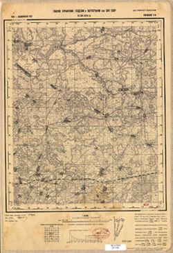
- Description:
- 1939
- Subject:
- Geographic Subject: Okovtsy, Topical Subject: Maps, and Topical Subject: Soviet Union
- Publisher:
- Главное управление геодезии и картографии при СНК СССР
- Language:
- Russian
- Date Created:
- 1941
- Identifier:
- VAC9619-003471
- Genre:
- Topographic Maps and Military Maps
- Geographic Location:
- Coordinates: 56.5, 33.25, 56.667, 33.5
- Related URL:
- Download GeoTIFF: https://drive.google.com/file/d/1QrCmf9strde4Q_XXo1Oe5tCoJFq2VFP6/view?usp=sharing and Catalog URL: http://iucat.iu.edu/catalog/5020131
- Abstract:
- Modern area represented: Оковцы (Okovtsy), Tverskaya oblast, Russia
- Call Number:
- G7000 s50 .S68 sheet O-36-127-B
- City:
- Оковцы (Okovtsy)
- Copyright Holder:
- No Copyright - United States
- Country:
- СССР (USSR)
- State/Province:
- Кировский район (Kirov district), Молодотудский район (Molodotudsky district), and Калининская область (Kalinin oblast)
- Physical Description:
- Scale: 1:50,000
- Persistent URL:
- http://purl.dlib.indiana.edu/iudl/images/VAC9619/VAC9619-003471
- Provenance:
- DMA Topographic Center, Army Map Service Library, OMAHA, Library of Congress Geography & Map Division
-
- Description:
- 1939
- Subject:
- Geographic Subject: Kiselevo, Topical Subject: Soviet Union, and Topical Subject: Maps
- Publisher:
- Главное управление геодезии и картографии при СНК СССР
- Language:
- Russian
- Date Created:
- 1941
- Identifier:
- VAC9619-002898
- Genre:
- Topographic Maps and Military Maps
- Geographic Location:
- Coordinates: 56.667, 33.75, 56.833, 34
- Related URL:
- Download GeoTIFF: https://drive.google.com/file/d/1iCxa_z7EiPxrrLftE7DkTTOitHYYW6yh/view?usp=sharing and Catalog URL: http://iucat.iu.edu/catalog/5020131
- Abstract:
- Modern area represented: Киселево (Kiselevo), Tverskaya oblast, Russia
- Call Number:
- GM G7000 s50 .S68 sheet O-36-116-D
- Caption:
- Для служебного пользования
- City:
- Киселево (Kiselevo)
- Copyright Holder:
- No Copyright - United States
- Country:
- СССР (USSR)
- State/Province:
- Луковниковский район (Lukovnikovsky district), Кировский район (Kirov district), and Калининская область (Kalinin oblast)
- Physical Description:
- Scale: 1:50,000
- Persistent URL:
- http://purl.dlib.indiana.edu/iudl/images/VAC9619/VAC9619-002898
- Provenance:
- DMA Topographic Center, Army Map Service Library, OMAHA, Library of Congress Geography & Map Division
-

- Description:
- 1939
- Subject:
- Topical Subject: Maps, Geographic Subject: Vyshegorod, and Topical Subject: Soviet Union
- Publisher:
- Главное управление геодезии и картографии при СНК СССР
- Language:
- Russian
- Date Created:
- 1941
- Identifier:
- VAC9619-002897
- Genre:
- Military Maps and Topographic Maps
- Geographic Location:
- Coordinates: 56.6667, 33.5, 56.8333, 33.75
- Related URL:
- Catalog URL: http://iucat.iu.edu/catalog/5020131 and Download GeoTIFF: https://drive.google.com/file/d/1Yz4ZBUF-IvzvEjei_et63zhO83cB3S2-/view?usp=sharing
- Abstract:
- Modern area represented: Вышегород (Vyshegorod), Tverskaya oblast, Russia
- Call Number:
- GM G7000 s50 .S68 sheet О-36-116-C
- Caption:
- Для служебного пользования
- City:
- Вышегород (Vyshegorod)
- Copyright Holder:
- No Copyright - United States
- Country:
- СССР (USSR)
- State/Province:
- Калининская область (Kalinin oblast) and Кировский район (Kirov district)
- Physical Description:
- Scale: 1:50,000
- Persistent URL:
- http://purl.dlib.indiana.edu/iudl/images/VAC9619/VAC9619-002897
- Provenance:
- DMA Topographic Center, Army Map Service Library, OMAHA, Library of Congress Geography & Map Division
-
- Description:
- 1939
- Subject:
- Geographic Subject: Brylevo, Topical Subject: Maps, and Topical Subject: Soviet Union
- Publisher:
- Главное управление геодезии и картографии при СНК СССР
- Language:
- Russian
- Date Created:
- 1941
- Identifier:
- VAC9619-002896
- Genre:
- Military Maps and Topographic Maps
- Geographic Location:
- Coordinates: 56.833, 33.75, 57, 34
- Related URL:
- Download GeoTIFF: https://drive.google.com/file/d/1Sei87ryO3y3FbwBurMqcWFN1Hz26k9j7/view?usp=sharing and Catalog URL: http://iucat.iu.edu/catalog/5020131
- Abstract:
- Modern area represented: Брылево (Brylevo), Tverskaya oblast, Russia
- Call Number:
- GM G7000 s50 .S68 sheet O-36-116-B
- Caption:
- Для служебного пользования
- City:
- Брылево (Brylevo)
- Copyright Holder:
- No Copyright - United States
- Country:
- СССР (USSR)
- State/Province:
- Кировский район (Kirov district), Каменский район (Kamensky district), Калининская область (Kalinin oblast), and Луковниковский район (Lukovnikovsky district)
- Physical Description:
- Scale: 1:50,000
- Persistent URL:
- http://purl.dlib.indiana.edu/iudl/images/VAC9619/VAC9619-002896
- Provenance:
- DMA Topographic Center, Army Map Service Library, OMAHA, Library of Congress Geography & Map Division
-

- Description:
- 1939
- Subject:
- Geographic Subject: Felistovo, Topical Subject: Maps, and Topical Subject: Soviet Union
- Publisher:
- Главное управление геодезии и картографии при СНК СССР
- Language:
- Russian
- Date Created:
- 1941
- Identifier:
- VAC9619-002894
- Genre:
- Military Maps and Topographic Maps
- Geographic Location:
- Coordinates: 56.667, 33.25, 56.833, 33.5
- Related URL:
- Download GeoTIFF: https://drive.google.com/file/d/1e3n-bYV2JUuoXJS278EseNAJhPVS7Wyc/view?usp=sharing and Catalog URL: http://iucat.iu.edu/catalog/5020131
- Abstract:
- Modern area represented: Фелистово (Felistovo), Tverskaya oblast, Russia
- Call Number:
- GM G7000 s50 .S68 sheet O-36-115-D
- Caption:
- Для служебного пользования
- City:
- Фелистово (Felistovo)
- Copyright Holder:
- No Copyright - United States
- Country:
- СССР (USSR)
- State/Province:
- Кировский район (Kirov district) and Калининская область (Kalinin oblast)
- Physical Description:
- Scale: 1:50,000
- Persistent URL:
- http://purl.dlib.indiana.edu/iudl/images/VAC9619/VAC9619-002894
- Provenance:
- DMA Topographic Center, Army Map Service Library, OMAHA, Library of Congress Geography & Map Division
-
- Description:
- 1939
- Subject:
- Topical Subject: Maps, Topical Subject: Soviet Union, and Geographic Subject: Berezug
- Publisher:
- Главное управление геодезии и картографии при СНК СССР
- Language:
- Russian
- Date Created:
- 1941
- Identifier:
- VAC9619-002895
- Genre:
- Topographic Maps and Military Maps
- Geographic Location:
- Coordinates: 56.833, 33.5, 57, 33.75
- Related URL:
- Catalog URL: http://iucat.iu.edu/catalog/5020131 and Download GeoTIFF: https://drive.google.com/file/d/117hKFp8W7arwEX0DOR-VCKzzwvS2-6nw/view?usp=sharing
- Abstract:
- Modern area represented: Березуг (Berezug), Tverskaya oblast, Russia
- Call Number:
- GM G7000 s50 .S68 sheet O-36-116-A
- Caption:
- Для служебного пользования
- City:
- Березуг (Berezug)
- Copyright Holder:
- No Copyright - United States
- Country:
- СССР (USSR)
- State/Province:
- Кировский район (Kirov district) and Калининская область (Kalinin oblast)
- Physical Description:
- Scale: 1:50,000
- Persistent URL:
- http://purl.dlib.indiana.edu/iudl/images/VAC9619/VAC9619-002895
- Provenance:
- DMA Topographic Center, Army Map Service Library, OMAHA, Library of Congress Geography & Map Division
-
- Description:
- 1939
- Subject:
- Geographic Subject: Dubrovki, Topical Subject: Maps, and Topical Subject: Soviet Union
- Publisher:
- Главное управление геодезии и картографии при СНК СССР
- Language:
- Russian
- Date Created:
- 1941
- Identifier:
- VAC9619-002893
- Genre:
- Military Maps and Topographic Maps
- Geographic Location:
- Coordinates: 56.667, 33, 56.833, 33.25
- Related URL:
- Catalog URL: http://iucat.iu.edu/catalog/5020131 and Download GeoTIFF: https://drive.google.com/file/d/11w3Bp0joUPKgvkQ2d6XuwvsEuh3saXCy/view?usp=sharing
- Abstract:
- Modern area represented: Дубровки (Dubrovki), Tverskaya oblast, Russia
- Call Number:
- GM G7000 s50 .S68 sheet O-36-115-C
- Caption:
- Для служебного пользования
- City:
- Дубровки (Dubrovki)
- Copyright Holder:
- No Copyright - United States
- Country:
- СССР (USSR)
- State/Province:
- Пеновский район (Penovsky district), Калининская область (Kalinin oblast), and Кировский район (Kirov district)
- Physical Description:
- Scale: 1:50,000
- Persistent URL:
- http://purl.dlib.indiana.edu/iudl/images/VAC9619/VAC9619-002893
- Provenance:
- DMA Topographic Center, Army Map Service Library, OMAHA, Library of Congress Geography & Map Division
-
- Description:
- 1939
- Subject:
- Topical Subject: Soviet Union, Topical Subject: Maps, and Geographic Subject: Sopkovo
- Publisher:
- Главное управление геодезии и картографии при СНК СССР
- Language:
- Russian
- Date Created:
- 1941
- Identifier:
- VAC9619-002844
- Genre:
- Topographic Maps and Military Maps
- Geographic Location:
- Coordinates: 57, 33.75, 57.167, 34
- Related URL:
- Catalog URL: http://iucat.iu.edu/catalog/5020131 and Download GeoTIFF: https://drive.google.com/file/d/18FH-llDMmXXbl0gZPsN4umcqhipvl5E2/view?usp=sharing
- Abstract:
- Modern area represented: Сопково (Sopkovo), Тверская область (Tverskaya oblast), Russia
- Call Number:
- GM G7000 s50 .S68 sheet O-36-104-D
- Caption:
- Для служебного пользования
- City:
- Сапково (Sapkovo)
- Copyright Holder:
- No Copyright - United States
- Country:
- СССР (USSR)
- State/Province:
- Калининская область (Kalinin oblast), Каменский район (Kamensky district), Есеновичский район (Yesenovichsky district), Кировский район (Kirov district), and...
- Physical Description:
- Scale: 1:50,000
- Persistent URL:
- http://purl.dlib.indiana.edu/iudl/images/VAC9619/VAC9619-002844
- Provenance:
- DMA Topographic Center, Army Map Service Library, OMAHA, Library of Congress Geography & Map Division
