
Search Constraints
You searched for:
Publisher
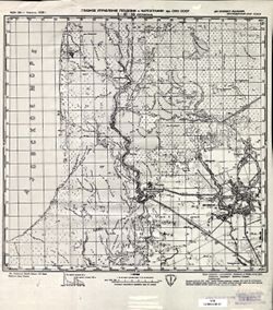
Главное управление геодезии и картографии при СНК СССР
Remove constraint Publisher: Главное управление геодезии и картографии при СНК СССР
Search Results
-
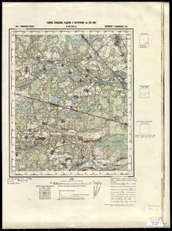
- Description:
- 1937
- Subject:
- Geographic Subject: Proletariy, Topical Subject: Soviet Union, and Topical Subject: Maps
- Publisher:
- Главное управление геодезии и картографии при СНК СССР
- Language:
- Russian
- Date Created:
- 1941
- Identifier:
- VAC9619-002142
- Genre:
- Military Maps and Topographic Maps
- Geographic Location:
- Coordinates: 58.3333, 31.5, 58.6667, 32
- Related URL:
- Download GeoTIFF: https://drive.google.com/open?id=12L0qcPIAf3-K_BKB7v2_qhW_7lHKoGC- and Catalog URL: https://iucat.iu.edu/catalog/5020129
- Abstract:
- Modern area represented: Пролетарий (Proletariy), Novgorodskaya oblast, Russia
- Call Number:
- G7000 s100 .S7 sheet O-36-52
- Caption:
- Для служебного пользования
- City:
- Пролетарий (Proletariy)
- Copyright Holder:
- No Copyright - United States
- Country:
- СССР (USSR)
- State/Province:
- РСФСР (RSFSR) and Ленинградская область (Leningrad oblast)
- Physical Description:
- Scale: 1:100,000
- Persistent URL:
- http://purl.dlib.indiana.edu/iudl/images/VAC9619/VAC9619-002142
- Provenance:
- DMA Topographic Center, Army Map Service Library, OMAHA, Library of Congress Geography & Map Division
-
- Description:
- 1939
- Subject:
- Geographic Subject: Antsiferovo, Topical Subject: Maps, and Topical Subject: Soviet Union
- Publisher:
- Главное управление геодезии и картографии при СНК СССР
- Language:
- Russian
- Date Created:
- 1941
- Identifier:
- VAC9619-002139
- Genre:
- Military Maps and Topographic Maps
- Geographic Location:
- Coordinates: 58.6667, 33.5, 59, 34
- Related URL:
- Download GeoTIFF: https://drive.google.com/open?id=1reMLcMwPh-i8CvoHxYbXFRANnH7FPI5z and Catalog URL: https://iucat.iu.edu/catalog/5020129
- Abstract:
- Modern area represented: Анциферово (Antsiferovo), Novgorodskaya oblast, Russia
- Call Number:
- G7000 s100 .S7 sheet O-36-44
- Caption:
- Captured map and Для служебного пользования
- City:
- Анциферово (Antsiferovo)
- Copyright Holder:
- No Copyright - United States
- Country:
- СССР (USSR)
- State/Province:
- РСФСР (RSFSR) and Ленинградская область (Leningrad oblast)
- Physical Description:
- Scale: 1:100,000
- Persistent URL:
- http://purl.dlib.indiana.edu/iudl/images/VAC9619/VAC9619-002139
- Provenance:
- DMA Topographic Center, Army Map Service Library, Library of Congress G & M Division
-
- Description:
- 1936
- Subject:
- Geographic Subject: Stavropol’ Kray, Topical Subject: Soviet Union, Geographic Subject: Trunovskoye, and Topical Subject: Maps
- Publisher:
- Главное управление геодезии и картографии при СНК СССР
- Language:
- Russian
- Date Created:
- 1941
- Identifier:
- VAC9619-002159
- Genre:
- Topographic Maps and Military Maps
- Geographic Location:
- Coordinates: 45.3333, 42, 45.6667, 42.5
- Related URL:
- Catalog URL: https://iucat.iu.edu/catalog/5020129 and Download GeoTIFF: https://drive.google.com/file/d/1tb7KRPgwX3gBKo-gLHWMvbXOeFbelWP1/view?usp=sharing
- Abstract:
- Modern area represented: Труновское (Trunovskoye), Stavropol’ Kray, Russia
- Call Number:
- G7000 s100 .S7 sheet L-38-85
- Caption:
- Для cлужебного пользования
- City:
- Труновское (Trunovskoye)
- Copyright Holder:
- No Copyright - United States
- Country:
- СССР (USSR)
- State/Province:
- Орджоникидзевский край (Ordzhonikidze kray) and РСФСР (RSFSR)
- Physical Description:
- Scale: 1:100,000
- Persistent URL:
- http://purl.dlib.indiana.edu/iudl/images/VAC9619/VAC9619-002159
- Provenance:
- DMA Topographic Center, Army Map Service Library, OMAHA
-
- Description:
- 1939
- Subject:
- Topical Subject: Soviet Union, Topical Subject: Maps, and Geographic Subject: Okhvat
- Publisher:
- Главное управление геодезии и картографии при СНК СССР
- Language:
- Russian
- Identifier:
- VAC9619-002890
- Genre:
- Military Maps and Topographic Maps
- Geographic Location:
- Coordinates: 56.667, 32.25, 56.833, 32.5
- Related URL:
- Catalog URL: http://iucat.iu.edu/catalog/5020131 and Download GeoTIFF: https://drive.google.com/file/d/12gpJLt5cYQ-4EyKfpoFZBoYFcmuVjtDC/view?usp=sharing
- Abstract:
- Modern area represented: Охват (Okhvat), Tverskaya oblast, Russia
- Call Number:
- GM G7000 s50 .S68 sheet O-36-113-D
- Caption:
- Для служебного пользования and Captured map
- City:
- Охват (Okhvat)
- Copyright Holder:
- No Copyright - United States
- Country:
- СССР (USSR)
- State/Province:
- Пеновский район (Penovsky district), Калининская область (Kalinin oblast), and Ленинский район (Leninsky district)
- Physical Description:
- Scale: 1:50,000
- Persistent URL:
- http://purl.dlib.indiana.edu/iudl/images/VAC9619/VAC9619-002890
- Provenance:
- Army Map Service Library, OMAHA, Library of Congress Geography & Map Division
-
- Description:
- 1936
- Subject:
- Topical Subject: Maps, Topical Subject: Soviet Union, and Geographic Subject: Goryatino
- Publisher:
- Главное управление геодезии и картографии при СНК СССР
- Language:
- Russian
- Date Created:
- 1941
- Identifier:
- VAC9619-002132
- Genre:
- Military Maps and Topographic Maps
- Geographic Location:
- Coordinates: 59, 32.5, 59.3333, 33
- Related URL:
- Catalog URL: https://iucat.iu.edu/catalog/5020129 and Download GeoTIFF: https://drive.google.com/open?id=17ZyE4IrTIjaZwCDcStK6hwrndEkvbgrM
- Abstract:
- Modern area represented: Goryatino, Leningrad oblast, Russia
- Call Number:
- G7000 s100 .S7 sheet O-36-30
- Caption:
- Для служебного пользования
- City:
- Горятино (Goryatino)
- Copyright Holder:
- No Copyright - United States
- Country:
- СССР (USSR)
- State/Province:
- Дрегельский район (Dregelsky district), РСФСР (RSFSR), Ленинградская область (Leningrad oblast), Киришский район (Kirishsky district), and Маловишерский райо...
- Physical Description:
- Scale: 1:100,000
- Persistent URL:
- http://purl.dlib.indiana.edu/iudl/images/VAC9619/VAC9619-002132
- Provenance:
- DMA Topographic Center, Army Map Service Library, OMAHA, Library of Congress Geography & Map Division
-
- Description:
- 1939
- Subject:
- Topical Subject: Soviet Union, Topical Subject: Maps, and Geographic Subject: Plakhino
- Publisher:
- Главное управление геодезии и картографии при СНК СССР
- Language:
- Russian
- Date Created:
- 1941
- Identifier:
- VAC9619-003129
- Genre:
- Military Maps and Topographic Maps
- Geographic Location:
- Coordinates: 54.333, 39, 54.667, 39.5
- Related URL:
- Download GeoTIFF: https://drive.google.com/file/d/17CIxp9whaiMgO3kCwIMiqkKPTjiVbflJ/view?usp=sharing and Catalog URL: https://iucat.iu.edu/catalog/5020129
- Abstract:
- Modern area represented: Плахино (Plakhino), Ryazanskaya oblast, Russia
- Call Number:
- G7000 s100 .S7 sheet N-37-55
- Caption:
- Для служебного пользования
- City:
- Плахино (Plakhino)
- Copyright Holder:
- No Copyright - United States
- Country:
- СССР (USSR)
- State/Province:
- Московская область (Moscow oblast) and Рязанская область (Ryazan oblast)
- Physical Description:
- Scale: 1:100,000
- Persistent URL:
- http://purl.dlib.indiana.edu/iudl/images/VAC9619/VAC9619-003129
- Provenance:
- DMA Topographic Center, Army Map Service Library, Library of Congress Geography & Map Division, Reichsamt für Landesaufnahme, Kartensammlung, Geographic ...
-
- Description:
- 1939
- Subject:
- Geographic Subject: Druzhnaya Gorka, Topical Subject: Maps, and Topical Subject: Soviet Union
- Publisher:
- Главное управление геодезии и картографии при СНК СССР
- Language:
- Russian
- Identifier:
- VAC9619-003376
- Genre:
- Topographic Maps and Military Maps
- Geographic Location:
- Coordinates: 58.333, 32.75, 58.5, 33
- Related URL:
- Catalog URL: http://iucat.iu.edu/catalog/5020131 and Download GeoTIFF: https://drive.google.com/file/d/1oGUheQvOXuuLP8IOCN-VUvVMS9T4NRqK/view?usp=sharing
- Abstract:
- Modern area represented: Дружная Горка (Druzhnaya Gorka), Novgorodskaya oblast, Russia
- Call Number:
- G7000 s50 .S68 sheet O-36-54-D
- Caption:
- Для служебного пользования
- City:
- Glupaya Gorka
- Copyright Holder:
- No Copyright - United States
- Country:
- СССР (USSR)
- State/Province:
- Ленинградская область (Leningrad oblast), Окуловский район (Okulovsky district), and Крестецкий район (Krestetsky district)
- Physical Description:
- Scale: 1:50,000
- Persistent URL:
- http://purl.dlib.indiana.edu/iudl/images/VAC9619/VAC9619-003376
- Provenance:
- DMA Topographic Center, Army Map Service Library, OMAHA, Library of Congress Geography & Map Division
-
- Description:
- 1934
- Subject:
- Topical Subject: Maps, Topical Subject: Soviet Union, and Geographic Subject: Petrovskaya
- Publisher:
- Главное управление геодезии и картографии при СНК СССР
- Language:
- Russian
- Date Created:
- 1938
- Identifier:
- VAC9619-002347
- Genre:
- Topographic Maps and Military Maps
- Geographic Location:
- Coordinates: 45.333, 37.5, 45.667, 38
- Related URL:
- Catalog URL: https://iucat.iu.edu/catalog/5020129 and Download GeoTIFF: https://drive.google.com/file/d/1029Jux4cMhV7T-CDlD5yFWtEeQSL-8ab/view?usp=sharing
- Abstract:
- Modern area represented: Petrovskaya, Russia
- Call Number:
- G7000 s100 .S7 sheet L-37-88
- Caption:
- Для служебного пользования
- City:
- Петровская (Petrovskaya)
- Copyright Holder:
- No Copyright - United States
- Country:
- СССР (USSR)
- State/Province:
- РСФСР (RSFSR) and Краснодарский край (Krasnodar kray)
- Physical Description:
- Scale: 1:100,000
- Persistent URL:
- http://purl.dlib.indiana.edu/iudl/images/VAC9619/VAC9619-002347
- Provenance:
- CIA Map Library
-
- Description:
- 1938
- Subject:
- Topical Subject: Soviet Union, Topical Subject: Maps, and Geographic Subject: Boykovo
- Publisher:
- Главное управление геодезии и картографии при СНК СССР
- Language:
- Russian
- Date Created:
- 1941
- Identifier:
- VAC9619-003447
- Genre:
- Military Maps and Topographic Maps
- Geographic Location:
- Coordinates: 56.833, 35.5, 57, 35.75
- Related URL:
- Download GeoTIFF: https://drive.google.com/file/d/1BdYV5wb7st8BaWASg6uGiYw9j6iroPEA/view?usp=sharing and Catalog URL: http://iucat.iu.edu/catalog/5020131
- Abstract:
- Modern area represented: Бойково (Boykovo), Tverskaya oblast, Russia
- Call Number:
- GM G7000 s50 .S68 sheet O-36-120-A
- City:
- Бойково (Boykovo)
- Copyright Holder:
- No Copyright - United States
- Country:
- СССР (USSR)
- State/Province:
- Медновский район (Mednovsky district), Калининский район (Kalininsky district), and Калининская область (Kalinin oblast)
- Physical Description:
- Scale: 1:50,000
- Persistent URL:
- http://purl.dlib.indiana.edu/iudl/images/VAC9619/VAC9619-003447
- Provenance:
- CIA Map Branch -- Received
-
- Description:
- 1939
- Subject:
- Topical Subject: Maps, Topical Subject: Soviet Union, and Geographic Subject: Nikiforovskoye
- Publisher:
- Главное управление геодезии и картографии при СНК СССР
- Language:
- Russian
- Date Created:
- 1941
- Identifier:
- VAC9619-003508
- Genre:
- Military Maps and Topographic Maps
- Geographic Location:
- Coordinates: 56.167, 34.75, 56.333, 35
- Related URL:
- Catalog URL: http://iucat.iu.edu/catalog/5020131 and Download GeoTIFF: https://drive.google.com/file/d/14gDli5M_EfZMq68zOWwoAldVf4cw81U9/view?usp=sharing
- Abstract:
- Modern area represented: Никифоровское (Nikiforovskoye), Tverskaya oblast, Russia
- Call Number:
- GM G7000 s50 .S68 sheet O-36-142-B
- City:
- Никифоровское (Nikiforovskoye)
- Copyright Holder:
- No Copyright - United States
- Country:
- СССР (USSR)
- State/Province:
- Калининская область (Kalinin oblast), Погорельский район (Pogorelsky district), Зубцовский район (Zubtsovsky district), and Старицкий район (Staritsky district)
- Physical Description:
- Scale: 1:50,000
- Persistent URL:
- http://purl.dlib.indiana.edu/iudl/images/VAC9619/VAC9619-003508
- Provenance:
- DMA Topographic Center, Army Map Service Library, OMAHA, Library of Congress Geography & Map Division
