
Search Constraints
You searched for:
Publisher
Управление военных топографов
Remove constraint Publisher: Управление военных топографов
Search Results
-
- Subject:
- Topical Subject: Maps, Geographic Subject: Камянець-Подільський (Kamianets-Podilskyi), and Topical Subject: Soviet Union
- Publisher:
- Управление военных топографов
- Language:
- Russian
- Identifier:
- VAC9619-000878
- Genre:
- Military Maps and Topographic Maps
- Geographic Location:
- Coordinates: 48.6667, 26.5, 48.8333, 26.75
- Related URL:
- Download GeoTIFF: https://drive.google.com/open?id=1d9zmDF1aOMAqfbDt_Z1j4-1yPA9Wetkx and Catalog URL: http://iucat.iu.edu/catalog/5020131
- Abstract:
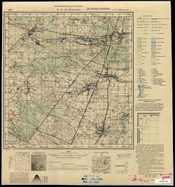
- Modern area represented: Камянець-Подільський (Kamianets-Podilskyi), Khmelnytskyi Oblast, Ukraine
- Call Number:
- G7000 s50 .S68 sheet M-35-114-C
- Caption:
- Не подлежит оглашению
- City:
- Каменец-Подольск (Kamenets-Podol’sk)
- Copyright Holder:
- No Copyright - United States
- Country:
- СССР (USSR)
- State/Province:
- Украинская ССР (Ukrainian Soviet Socialist Republic) and Винницкая область (Vinnytsia oblast)
- Physical Description:
- Scale: 1:50,000
- Persistent URL:
- http://purl.dlib.indiana.edu/iudl/images/VAC9619/VAC9619-000878
- Provenance:
- CIA Map Branch -- Received
-
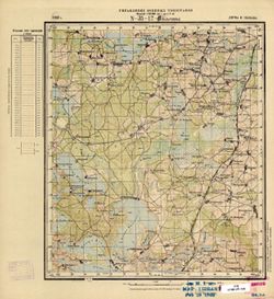
- Description:
- 1903
- Subject:
- Topical Subject: Soviet Union, Geographic Subject: Lõupõllu, and Topical Subject: Maps
- Publisher:
- Управление военных топографов
- Language:
- Russian
- Identifier:
- VAC9619-001716
- Genre:
- Military Maps and Topographic Maps
- Geographic Location:
- Coordinates: 58, 22, 58.167, 22.25
- Related URL:
- Catalog URL: http://iucat.iu.edu/catalog/5020131 and Download GeoTIFF: https://drive.google.com/open?id=11lJfJHVkbZq4tdtFpuMRnRt9Le89XSLS
- Abstract:
- Modern area represented: Lõupõllu, Saare county, Estonia
- Call Number:
- G7000 s50 .S68 sheet O-34-69-C
- City:
- Леопелло (Lõupõllu)
- Copyright Holder:
- No Copyright - United States
- Country:
- Эстония (Estonia)
- Physical Description:
- Scale: 1:50,000
- Persistent URL:
- http://purl.dlib.indiana.edu/iudl/images/VAC9619/VAC9619-001716
- Provenance:
- CIA Map Branch -- Received
-
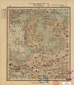
- Description:
- 1927
- Subject:
- Geographic Subject: Hvozdavka Druha, Topical Subject: Maps, Geographic Subject: Hvozdavka Persha, and Topical Subject: Soviet Union
- Publisher:
- Управление военных топографов
- Language:
- Russian
- Identifier:
- VAC9619-000118
- Genre:
- Military Maps and Topographic Maps
- Geographic Location:
- Coordinates: 47.8333, 30, 48, 30.25
- Related URL:
- Download GeoTIFF: https://drive.google.com/open?id=1SO72YG1VGyq5w1BQaBhlf1XJy0bjJxuu and Catalog URL: http://iucat.iu.edu/catalog/5020131
- Abstract:
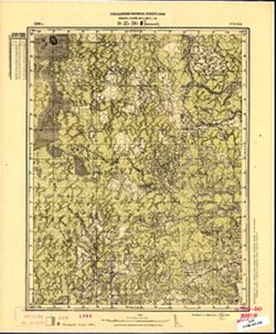
- Modern area represented: Hvozdavka Persha and Hvozdavka Druha, Odessa oblast, Ukraine
- Call Number:
- G7000 s50 .S68 sheet L-36-1-A
- Caption:
- Не подлежит оглашению
- City:
- Гвоздавка (Gvozdavka)
- Copyright Holder:
- No Copyright - United States
- Country:
- СССР (USSR)
- State/Province:
- Одесская область (Odessa oblast) and Украинская ССР (Ukrainian Soviet Socialist Republic)
- Physical Description:
- Scale: 1:50,000
- Persistent URL:
- http://purl.dlib.indiana.edu/iudl/images/VAC9619/VAC9619-000118
- Provenance:
- M. I. Map Library, G000-30, GS, RA, Atlasblatt
-
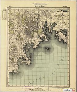
- Subject:
- Geographic Subject: Polatsk, Topical Subject: Soviet Union, and Topical Subject: Maps
- Publisher:
- Управление военных топографов
- Language:
- Russian
- Identifier:
- VAC9619-000471
- Genre:
- Topographic Maps and Military Maps
- Geographic Location:
- Coordinates: 55.3333, 28.75, 55.5, 29
- Related URL:
- Catalog URL: http://iucat.iu.edu/catalog/5020131, https://drive.google.com/file/d/1TY-0kTKyfdgF2LLcg73BzOAkT5uqYwUa/view?usp=sharing, and Download GeoTIFF: h...
- Abstract:
- Modern area represented: Polatsk, Vitebsk oblast, Belarus
- Call Number:
- G7000 s50 .S68 sheet N-35-22-D
- Caption:
- Не подлежит оглашению
- City:
- Полоцк (Polotsk)
- Copyright Holder:
- No Copyright - United States
- Country:
- СССР (USSR)
- State/Province:
- Белорусская ССР (Byelorussian Soviet Socialist Republic)
- Physical Description:
- Scale: 1:50,000
- Persistent URL:
- http://purl.dlib.indiana.edu/iudl/images/VAC9619/VAC9619-000471
- Provenance:
- M. I. Map Library, Library of Congress Geography & Map Division, GS, RA, G000-30, Atlasblatt
-
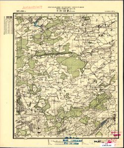
- Description:
- 1902
- Subject:
- Geographic Subject: Kazitiškis, Topical Subject: Maps, and Topical Subject: Soviet Union
- Publisher:
- Управление военных топографов
- Language:
- Russian
- Identifier:
- VAC9619-000450
- Genre:
- Topographic Maps and Military Maps
- Geographic Location:
- Coordinates: 55.3333, 26, 55.5, 26.25
- Related URL:
- Download GeoTIFF: https://drive.google.com/open?id=1qSG9HAzBq9PNrgPcCBNNRerimkXIv6Wv and Catalog URL: http://iucat.iu.edu/catalog/5020131
- Abstract:
- Modern area represented: Kazitiškis, Lithuania
- Call Number:
- G7000 s50 .S68 sheet N-35-17-C
- City:
- Казачизна (Kazachizna)
- Copyright Holder:
- No Copyright - United States
- Country:
- Польша (Poland) and Литва (Lithuania)
- Physical Description:
- Scale: 1:50,000
- Persistent URL:
- http://purl.dlib.indiana.edu/iudl/images/VAC9619/VAC9619-000450
- Provenance:
- M. I. Map Library, Justus Perthes Kartensammlung
-
- Description:
- 1905
- Subject:
- Topical Subject: Maps, Topical Subject: Soviet Union, and Geographic Subject: Audla
- Publisher:
- Управление военных топографов
- Language:
- Russian
- Identifier:
- VAC9619-001705
- Genre:
- Topographic Maps and Military Maps
- Geographic Location:
- Coordinates: 58.333, 23, 58.5, 23.25
- Related URL:
- Download GeoTIFF: https://drive.google.com/open?id=1JuXvZ3izZp7jsvaFWmo0ubcbnFcrSvvD and Catalog URL: http://iucat.iu.edu/catalog/5020131
- Abstract:
- Modern area represented: Audla, Saare county, Estonia
- Call Number:
- G7000 s50 .S68 sheet O-34-59-C
- City:
- Аудла (Audla)
- Copyright Holder:
- No Copyright - United States
- Country:
- Эстония (Estonia)
- Physical Description:
- Scale: 1:50,000
- Persistent URL:
- http://purl.dlib.indiana.edu/iudl/images/VAC9619/VAC9619-001705
- Provenance:
- CIA Map Branch -- Received
-
- Description:
- 1927
- Subject:
- Topical Subject: Maps, Geographic Subject: Obal', and Topical Subject: Soviet Union
- Publisher:
- Управление военных топографов
- Language:
- Russian
- Identifier:
- VAC9619-000475
- Genre:
- Topographic Maps and Military Maps
- Geographic Location:
- Coordinates: 55.3333, 29.25, 55.5, 29.5
- Related URL:
- Download GeoTIFF: https://drive.google.com/open?id=1428G9RMQGVjNdCQONPzIAHOxW1ev1rmz and Catalog URL: http://iucat.iu.edu/catalog/5020131
- Abstract:
- Modern area represented: Обаль (Obal'), Vitebsk District, Belarus
- Call Number:
- G7000 s50 .S68 sheet N-35-23-D
- Caption:
- Не подлежит оглашению
- City:
- Оболь (Obol')
- Copyright Holder:
- No Copyright - United States
- Country:
- СССР (USSR)
- State/Province:
- Белорусская ССР (Byelorussian Soviet Socialist Republic)
- Physical Description:
- Scale: 1:50,000
- Persistent URL:
- http://purl.dlib.indiana.edu/iudl/images/VAC9619/VAC9619-000475
- Provenance:
- M. I. Map Library, Library of Congress Geography & Map Division
-
- Description:
- 1897
- Subject:
- Topical Subject: Soviet Union, Geographic Subject: Žagarė, and Topical Subject: Maps
- Publisher:
- Управление военных топографов
- Language:
- Russian
- Date Created:
- 1910
- Identifier:
- VAC9619-001744
- Genre:
- Topographic Maps and Military Maps
- Geographic Location:
- Coordinates: 56.333, 23, 56.5, 23.25
- Related URL:
- Download GeoTIFF: https://drive.google.com/open?id=1dy-Du-fXv4uWDGOzK_z_Ade1D5-obnUv and Catalog URL: http://iucat.iu.edu/catalog/5020131
- Abstract:
- Modern area represented: Žagarė, Joniškis district, Lithuania
- Call Number:
- G7000 s50 .S68 sheet O-34-131-C
- City:
- Жагарэ (Žagarė)
- Copyright Holder:
- No Copyright - United States
- Country:
- Латвия (Latvia) and Литва (Lithuania)
- Physical Description:
- Scale: 1:50,000
- Persistent URL:
- http://purl.dlib.indiana.edu/iudl/images/VAC9619/VAC9619-001744
- Provenance:
- M. I. Map Library, Atlasblatt, GS, RA
-
- Description:
- 1932
- Subject:
- Geographic Subject: Mykhaylivka, Topical Subject: Maps, and Topical Subject: Soviet Union
- Publisher:
- Управление военных топографов
- Language:
- Russian
- Identifier:
- VAC9619-000214
- Genre:
- Military Maps and Topographic Maps
- Geographic Location:
- Coordinates: 51, 28.5, 51.167, 28.75
- Related URL:
- Catalog URL: http://iucat.iu.edu/catalog/5020131 and Download GeoTIFF: https://drive.google.com/open?id=1cMFudbbQW6FGbl0T2Tc0MBTovoarSPSG
- Abstract:
- Modern area represented: Mykhaylivka, Zhytomyr oblast, Ukraine
- Call Number:
- G7000 s50 .S68 sheet M-35-34-C
- Caption:
- Не подлежит оглашению
- City:
- Михайловка (Mikhaylovka)
- Copyright Holder:
- No Copyright - United States
- Country:
- СССР (USSR)
- State/Province:
- Украинская ССР (Ukrainian Soviet Socialist Republic) and Киевская область (Kyiv oblast)
- Physical Description:
- Scale: 1:50,000
- Persistent URL:
- http://purl.dlib.indiana.edu/iudl/images/VAC9619/VAC9619-000214
- Provenance:
- M. I. Map Library, G000-30, GS, RA, Atlasblatt
-
- Description:
- 1896
- Subject:
- Geographic Subject: Änniksaare, Topical Subject: Soviet Union, and Topical Subject: Maps
- Publisher:
- Управление военных топографов
- Language:
- Russian
- Date Created:
- 1931
- Identifier:
- VAC9619-001843
- Genre:
- Topographic Maps and Military Maps
- Geographic Location:
- Coordinates: 59, 26.75, 59.167, 27
- Related URL:
- Download GeoTIFF: https://drive.google.com/open?id=1kS6jsPitI20_cxjwC2TAMFS1iE7MdkuY and Catalog URL: http://iucat.iu.edu/catalog/5020131
- Abstract:
- Modern area represented: Änniksaare, Estonia
- Call Number:
- G7000 s50 .S68 sheet O-35-30-D
- City:
- Энниксаар (Änniksaare)
- Copyright Holder:
- No Copyright - United States
- Country:
- Эстония (Estonia)
- Physical Description:
- Scale: 1:50,000
- Persistent URL:
- http://purl.dlib.indiana.edu/iudl/images/VAC9619/VAC9619-001843
- Provenance:
- CIA Map Branch -- Received, G000-30
