
Search Constraints
You searched for:
Date Created
1932
Remove constraint Date Created: 1932
Subject
Topical Subject: Maps
Remove constraint Subject: Topical Subject: Maps
« Previous |
1 - 10 of 53
|
Next »
Search Results
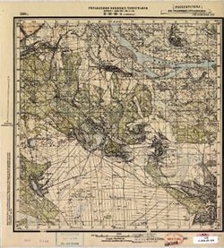
-
- Description:
- 1931
- Subject:
- Topical Subject: Maps, Geographic Subject: Pavlysh, and Topical Subject: Soviet Union
- Publisher:
- Управление военных топографов РККА
- Language:
- Russian
- Date Created:
- 1932
- Identifier:
- VAC9619-001093
- Genre:
- Military Maps and Topographic Maps
- Geographic Location:
- Coordinates: 48.833, 33.25, 49, 33.5
- Related URL:
- Catalog URL: http://iucat.iu.edu/catalog/5020131 and Download GeoTIFF: https://drive.google.com/open?id=1sMRslNs7Ya7e0przcNxz1C8CJMYdNijj
- Abstract:
- Modern area represented: Pavlysh, Kirovohrad oblast, Ukraine
- Call Number:
- G7000 s50 .S68 М-36-115-Б
- Caption:
- Не подлежит оглашению
- City:
- Павлыш (Pavlysh)
- Copyright Holder:
- No Copyright - United States
- Country:
- СССР (USSR)
- State/Province:
- Харьковская область (Kharkiv oblast), Украинская ССР (Ukrainian Soviet Socialist Republic), and Днепропетровская область (Dnipropetrovsk oblast)
- Physical Description:
- Scale: 1:50,000
- Persistent URL:
- http://purl.dlib.indiana.edu/iudl/images/VAC9619/VAC9619-001093
- Provenance:
- DMA Topographic Center, Army Map Service Library, Library of Congress Geography & Map Division
-
- Description:
- 1931
- Subject:
- Geographic Subject: Prigarovka, Topical Subject: Soviet Union, and Topical Subject: Maps
- Publisher:
- Управление военных топографов
- Language:
- Russian
- Date Created:
- 1932
- Identifier:
- VAC9619-001075
- Genre:
- Military Maps and Topographic Maps
- Geographic Location:
- Coordinates: 49, 33.75, 49.167, 34
- Related URL:
- Catalog URL: http://iucat.iu.edu/catalog/5020131 and Download GeoTIFF: https://drive.google.com/open?id=1f6wjuPrc3Ux9DrlosAXfFGB4gFxqmSmk
- Abstract:
- Modern area represented: Prigarovka, Poltava oblast, Ukraine
- Call Number:
- G7000 s50 .S68 М-36-104-Г
- Caption:
- Не подлежит оглашению
- City:
- Пригаривка (Prigarovka)
- Copyright Holder:
- No Copyright - United States
- Country:
- СССР (USSR)
- State/Province:
- Украинская ССР (Ukrainian Soviet Socialist Republic) and Харьковская область (Kharkiv oblast)
- Physical Description:
- Scale: 1:50,000
- Persistent URL:
- http://purl.dlib.indiana.edu/iudl/images/VAC9619/VAC9619-001075
- Provenance:
- DMA Topographic Center, Army Map Service Library, OMAHA, Library of Congress Geography & Map Division
-
- Description:
- 1928
- Subject:
- Geographic Subject: Jablunkov, Topical Subject: Soviet Union, and Topical Subject: Maps
- Publisher:
- Генеральный штаб РККА
- Language:
- Russian
- Date Created:
- 1932
- Identifier:
- VAC9619-003021
- Genre:
- Topographic Maps and Military Maps
- Geographic Location:
- Coordinates: 49.333, 18.5, 49.667, 19
- Related URL:
- Download GeoTIFF: https://drive.google.com/file/d/1r9qgCozS6EmDxVfuw5y918X_Xdu1snkj/view?usp=sharing and Catalog URL: https://iucat.iu.edu/catalog/5020129
- Abstract:
- Modern area represented: Jablunkov, Moravian-Silesian region, Czech Republic
- Call Number:
- G7000 s100 .S7 sheet M-34-86
- City:
- Яблунков (Jablunkov)
- Copyright Holder:
- No Copyright - United States
- Country:
- Чехословакия (Czechoslovakia) and Польша (Poland)
- Physical Description:
- Scale: 1:100,000
- Persistent URL:
- http://purl.dlib.indiana.edu/iudl/images/VAC9619/VAC9619-003021
- Provenance:
- DMA Topographic Center, Army Map Service Library, OMAHA, Library of Congress Geography & Map Division
-
- Description:
- 1903
- Subject:
- Topical Subject: Soviet Union, Geographic Subject: Starokostiantyniv, and Topical Subject: Maps
- Publisher:
- Генеральный штаб РККА
- Language:
- Russian
- Date Created:
- 1932
- Identifier:
- VAC9619-003224
- Genre:
- Military Maps and Topographic Maps
- Geographic Location:
- Coordinates: 49.667, 27, 50, 27.5
- Related URL:
- Download GeoTIFF: https://drive.google.com/file/d/1WZ-h8zC8CR1miztk7aJtZNqur3A6_XAm/view?usp=sharing and Catalog URL: https://iucat.iu.edu/catalog/5020129
- Abstract:
- Modern area represented: Starokostiantyniv, Khmelnytskyi oblast, Ukraine
- Call Number:
- G7000 s100 .S7 sheet M-35-79
- Caption:
- Не подлежит оглашению
- City:
- Старо-Константинов (Staro-Kostiantyniv)
- Copyright Holder:
- No Copyright - United States
- Country:
- СССР (USSR)
- State/Province:
- Каменец-Подольская область (Kamianets-Podilskyi oblast) and Украинская ССР (Ukrainian Soviet Socialist Republic)
- Physical Description:
- Scale: 1:100,000
- Persistent URL:
- http://purl.dlib.indiana.edu/iudl/images/VAC9619/VAC9619-003224
- Provenance:
- DMA Topographic Center, Army Map Service Library, OMAHA, Library of Congress Geography & Map Division
-
- Description:
- 1929
- Subject:
- Geographic Subject: Moshny, Topical Subject: Soviet Union, and Topical Subject: Maps
- Publisher:
- Управление военных топографов
- Language:
- Russian
- Date Created:
- 1932
- Identifier:
- VAC9619-001027
- Genre:
- Military Maps and Topographic Maps
- Geographic Location:
- Coordinates: 49.5, 31.5, 49.6667, 31.75
- Related URL:
- Catalog URL: http://iucat.iu.edu/catalog/5020131 and Download GeoTIFF: https://drive.google.com/open?id=1YDdnSgfHB6iMpwwVJPx9zoDfBiEx-g7S
- Abstract:
- Modern area represented: Мошни (Moshny), Cherkasy oblast, Ukraine
- Call Number:
- G7000 s50 .S68 sheet M-36-88-A
- Caption:
- Рассекречено and Не подлежит оглашению
- City:
- Мошны (Moshny)
- Copyright Holder:
- No Copyright - United States
- Country:
- СССР (USSR)
- State/Province:
- Украинская ССР (Ukrainian Soviet Socialist Republic)
- Physical Description:
- Scale: 1:50,000
- Persistent URL:
- http://purl.dlib.indiana.edu/iudl/images/VAC9619/VAC9619-001027
- Provenance:
- M. I. Map Library, Library of Congress Geography & Map Division
-
- Description:
- 1931
- Subject:
- Topical Subject: Maps, Geographic Subject: Deriyivka, and Topical Subject: Soviet Union
- Publisher:
- Управление военных топографов
- Language:
- Russian
- Date Created:
- 1932
- Identifier:
- VAC9619-001096
- Genre:
- Topographic Maps and Military Maps
- Geographic Location:
- Coordinates: 48.833, 33.75, 49, 34
- Related URL:
- Catalog URL: http://iucat.iu.edu/catalog/5020131 and Download GeoTIFF: https://drive.google.com/open?id=1LN7i_LoBas4-BCPYShFOW-PILcYQ7657
- Abstract:
- Modern area represented: Deriyivka, Kirovohrad oblast, Ukraine
- Call Number:
- G7000 s50 .S68 М-36-116-Б
- Caption:
- Не подлежит оглашению
- City:
- Дериевка (Deriyivka)
- Copyright Holder:
- No Copyright - United States
- Country:
- СССР (USSR)
- State/Province:
- Киевская область (Kyiv oblast) and Украинская ССР (Ukrainian Soviet Socialist Republic)
- Physical Description:
- Scale: 1:50,000
- Persistent URL:
- http://purl.dlib.indiana.edu/iudl/images/VAC9619/VAC9619-001096
- Provenance:
- DMA Topographic Center, Army Map Service Library, OMAHA, Library of Congress Geography & Map Division
-
- Description:
- 1923
- Subject:
- Topical Subject: Maps, Topical Subject: Soviet Union, and Geographic Subject: Obukhiv
- Publisher:
- Генеральный штаб РККА
- Language:
- Russian
- Date Created:
- 1932
- Identifier:
- VAC9619-003292
- Genre:
- Topographic Maps and Military Maps
- Geographic Location:
- Coordinates: 50, 30.5, 50.333, 31
- Related URL:
- Download GeoTIFF: https://drive.google.com/file/d/1IKU5S1he-loKUI7NMcg8yD1GeraYdNob/view?usp=sharing and Catalog URL: https://iucat.iu.edu/catalog/5020129
- Abstract:
- Modern area represented: Obukhiv, Kiev oblast, Ukraine
- Call Number:
- G7000 s100 .S7 sheet M-36-62
- Caption:
- Для служебного пользования
- City:
- Обухов (Obukhiv)
- Copyright Holder:
- No Copyright - United States
- Country:
- СССР (USSR)
- State/Province:
- Киевская область (Kyiv oblast) and Украинская ССР (Ukrainian Soviet Socialist Republic)
- Physical Description:
- Scale: 1:100,000
- Persistent URL:
- http://purl.dlib.indiana.edu/iudl/images/VAC9619/VAC9619-003292
- Provenance:
- DMA Topographic Center, Army Map Service Library, OMAHA, Library of Congress Geography & Map Division
-
- Description:
- 1893
- Subject:
- Topical Subject: Maps, Topical Subject: Soviet Union, and Geographic Subject: Jonava
- Publisher:
- Генеральный штаб РККА
- Language:
- Russian
- Date Created:
- 1932
- Identifier:
- VAC9619-004028
- Genre:
- Military Maps and Topographic Maps
- Geographic Location:
- Coordinates: 55, 24, 55.333, 24.5
- Related URL:
- Catalog URL: https://iucat.iu.edu/catalog/5020129 and Download GeoTIFF: https://drive.google.com/file/d/1JvGl1RJM5BUAjk9eFNYkYyBPV_ejY9-u/view?usp=sharing
- Abstract:
- Modern area represented: Jonava, Lithuania
- Call Number:
- G7000 s100 .S7 sheet N-35-25
- City:
- Йонава (Jonava)
- Copyright Holder:
- No Copyright - United States
- Country:
- Литва (Lithuania)
- Physical Description:
- Scale: 1:100,000
- Persistent URL:
- http://purl.dlib.indiana.edu/iudl/images/VAC9619/VAC9619-004028
- Provenance:
- DMA Topographic Center, Army Map Service Library
-
- Description:
- 1886
- Subject:
- Geographic Subject: Krynki, Topical Subject: Soviet Union, and Topical Subject: Maps
- Publisher:
- Генеральный штаб РККА
- Language:
- Russian
- Date Created:
- 1932
- Identifier:
- VAC9619-003973
- Genre:
- Military Maps and Topographic Maps
- Geographic Location:
- Coordinates: 53, 23.5, 53.333, 24
- Related URL:
- Download GeoTIFF: https://drive.google.com/file/d/1cYQBXgCPiDuroIh8MWthVwa6_PJlmpLm/view?usp=sharing and Catalog URL: https://iucat.iu.edu/catalog/5020129
- Abstract:
- Modern area represented: Krynki, Podlaskie Voivodeship, Poland
- Call Number:
- G7000 s100 .S7 sheet N-34-108
- City:
- Крынки (Krynki)
- Copyright Holder:
- No Copyright - United States
- Country:
- Польша (Poland)
- Physical Description:
- Scale: 1:100,000
- Persistent URL:
- http://purl.dlib.indiana.edu/iudl/images/VAC9619/VAC9619-003973
- Provenance:
- DMA Topographic Center, Army Map Service Library
-
- Description:
- 1925
- Subject:
- Geographic Subject: Polatsk, Topical Subject: Maps, and Topical Subject: Soviet Union
- Publisher:
- Управление военных топографов
- Language:
- Russian
- Date Created:
- 1932
- Identifier:
- VAC9619-000470
- Genre:
- Military Maps and Topographic Maps
- Geographic Location:
- Coordinates: 55.333, 28.75, 55.5, 29
- Related URL:
- Download GeoTIFF: https://drive.google.com/open?id=1faHCEBuaKkSPw26l0rLHB4BYDue5swTt and Catalog URL: http://iucat.iu.edu/catalog/5020131
- Abstract:
- Modern area represented: Polatsk, Vitebsk oblast, Belarus
- Call Number:
- G7000 s50 .S68 sheet N-35-22-D
- Caption:
- Не подлежит оглашению
- City:
- Полоцк (Polotsk)
- Copyright Holder:
- No Copyright - United States
- Country:
- СССР (USSR)
- State/Province:
- Белорусская ССР (Byelorussian Soviet Socialist Republic)
- Physical Description:
- Scale: 1:50,000
- Persistent URL:
- http://purl.dlib.indiana.edu/iudl/images/VAC9619/VAC9619-000470
- Provenance:
- M. I. Map Library, Library of Congress Geography & Map Division, GS, RA, G000-30, Atlasblatt
