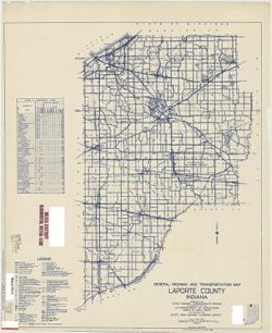
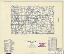
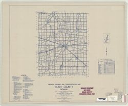
Topical Subject: Roads and Geographic Subject: Greene County (Ind.)
Creator:
Indiana. State Highway Commission (1919-1953)
Publisher:
Indiana. State Highway Commission (1919-1953)
Date Created:
1953
Identifier:
VAC3073-M-00342
Genre:
Road maps
Geographic Location:
Coordinates: W0871400 W0864100 N0391000 N0385400
Related URL:
Catalog URL: www.iucat.iu.edu/catalog/5729005
Abstract:
blueline. "State roads revised to January 1, 1953." "Data obtained from State-wide Highway Planning Survey." Includes chart "Culture...
Call Number:
G4093.G7P2 1953 .I53
Caption:
Imprint: [Indianapolis?] : State Highway Commission of Indiana, 1949.
Physical Description:
Dimensions: 44 x 51 cm and Scale: Approximately 1:130,000
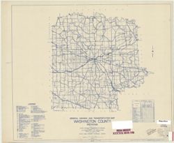
Geographic Subject: Monroe County (Ind.) and Topical Subject: Roads
Creator:
Indiana. State Highway Commission (1919-1953)
Publisher:
Indiana. State Highway Commission (1919-1953)
Date Created:
1937
Identifier:
VAC3073-M-00994
Genre:
Road maps
Geographic Location:
Coordinates: W0864100 W0861900 N0392100 N0390000
Related URL:
Catalog URL: https://iucat.iu.edu/catalog/5706988
Abstract:
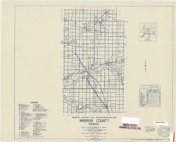
Blueline. "1937." "53." "Corrected to January 1, 1937." Includes location map and chart of "Culture in unincorporated plac...
Call Number:
G4093.M7P2 1937 .I52
Caption:
Imprint: [Indianapolis] : State Highway Commission of Indiana, 1937.
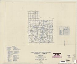
Geographic Subject: Fayette County (Ind.) and Topical Subject: Roads
Creator:
Indiana. State Highway Commission (1919-1953)
Publisher:
State Highway Commission of Indiana
Date Created:
1949
Identifier:
VAC3073-M-00960
Genre:
Road maps
Geographic Location:
Coordinates: W0851800 W0850200 N0394700 N0393200
Related URL:
Catalog URL: https://iucat.iu.edu/catalog/5704581
Abstract:
Blueline. "State roads revised to January 1, 1949." "Data obtained from State-wide Highway Planning Survey." Includes chart "Culture...
Call Number:
G4093.F3P2 1949 .I53
Caption:
Imprint: [Indianapolis?] : State Highway Commission of Indiana. 1949.
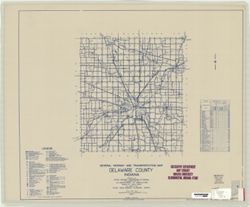
Geographic Subject: Delaware County (Ind.) and Topical Subject: Roads
Creator:
Indiana. State Highway Commission (1919-1953)
Publisher:
Indiana. State Highway Commission (1919-1953)
Date Created:
1937
Identifier:
VAC3073-M-00364
Genre:
Road maps
Geographic Location:
Coordinates: W0853500 W0851300 N0402300 N0400500
Related URL:
Catalog URL: https://iucat.iu.edu/catalog/5361381
Abstract:
Blue line print. "Corrected to January 1, 1937." "Data obtained from Statewide Highway Planning Survey." Includes chart "Culture...
Appears in Report of State Highway Commission. In Year book of the state of Indiana for the year 1917. Indianapolis : Wm. B. Burford, contractor for state pr...
Call Number:
JK5631 .I6 1917
Caption:
Imprint: [Indianapolis] : [Wm. B. Burford, contractor for state printing and binding], [1918]
Physical Description:
Scale: Approximately 1:2,600,000 and Dimensions: on sheet 15 x 25 cm
Alternate Identifier:
Alternate ID: 397754IP and Title Control Number: a18422936
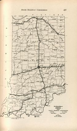
Shows roads by surface and composition type as well as standard Indiana road signs and the locations of state parks, state owned property, bodies of water, p...
Call Number:
G4091.P2 1932 .I5
Caption:
Imprint: [Indianapolis] : [Wm. B. Burford, contractor for state printing and binding], [1933] and Imprint: [Indianapolis] : [The Legislative Bureau], [1933]
Physical Description:
Dimensions: 41 x 27, on sheet 44 x 29 cm and Scale: Approximately 1:1,200,000
Alternate Identifier:
Alternate ID: 397754IP and Title Control Number: a18422897


![State highway system of Indiana [1932]](https://iiif.uits.iu.edu/iiif/2/7h14bt114%2Ffiles%2F6d61eaca-5c86-4d06-b214-7a3e8f654b70/full/250,/0/default.jpg)