
Search Constraints
You searched for:
State/Province
РСФСР (RSFSR)
Remove constraint State/Province: РСФСР (RSFSR)
« Previous |
1 - 100 of 1,385
|
Next »
Search Results
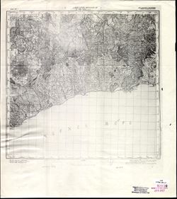
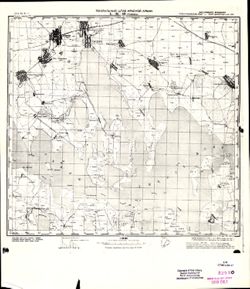
-
- Description:
- 1905
- Subject:
- Topical Subject: Maps, Topical Subject: Soviet Union, and Geographic Subject: Lazarevskoye
- Publisher:
- Генеральный штаб Красной Армии
- Language:
- Russian
- Date Created:
- 1942
- Identifier:
- VAC9619-000759
- Genre:
- Topographic Maps and Military Maps
- Geographic Location:
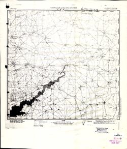
- Coordinates: 43.6667, 39, 44, 39.5
- Related URL:
- Catalog URL: https://iucat.iu.edu/catalog/5020129 and Download GeoTIFF: https://drive.google.com/open?id=1OcoSmUSM2ZO6HwjSl9T2sxJaHo8Fbzui
- Abstract:
- Modern area represented: Lazarevskoye, Krasnodar kray, Russia
- Call Number:
- G7000 s100 .S7 sheet K-37-7
- Caption:
- Для служебного пользования
- City:
- Лазаревская (Lazarevskoye)
- Copyright Holder:
- No Copyright - United States
- Country:
- СССР (USSR)
- State/Province:
- Краснодарская область (Krasnodar oblast) and РСФСР (RSFSR)
- Physical Description:
- Scale: 1:100,000
- Persistent URL:
- http://purl.dlib.indiana.edu/iudl/images/VAC9619/VAC9619-000759
- Provenance:
- CIA Map Library
-
- Description:
- 1903
- Subject:
- Geographic Subject: Detlyazhka, Topical Subject: Maps, and Topical Subject: Soviet Union
- Publisher:
- Генеральный штаб Красной Армии
- Language:
- Russian
- Identifier:
- VAC9619-000752
- Genre:
- Military Maps and Topographic Maps
- Geographic Location:
- Coordinates: 39.5, 43.6667, 40, 44
- Related URL:
- Download GeoTIFF: https://drive.google.com/open?id=1diaa3kPb__e1IZYQ7bRW53NrZIWTa3bv and Catalog URL: https://iucat.iu.edu/catalog/5020129
- Abstract:
- Modern area represented: Detlyazhka, Krasnodar kray, Russia
- Call Number:
- G7000 s100 .S7 sheet K-37-8
- Caption:
- Для служебного пользования
- Copyright Holder:
- No Copyright - United States
- Country:
- СССР (USSR)
- State/Province:
- Краснодарский край (Krasnodar kray) and РСФСР (RSFSR)
- Physical Description:
- Scale: 1:100,000
- Persistent URL:
- http://purl.dlib.indiana.edu/iudl/images/VAC9619/VAC9619-000752
- Provenance:
- CIA Map Library, Atlasblatt
-
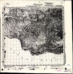
- Description:
- 1908
- Subject:
- Topical Subject: Soviet Union, Geographic Subject: Dzheguta, and Topical Subject: Maps
- Publisher:
- НКЗ СССР Сельхозаэросъемка
- Language:
- Russian
- Date Created:
- 1941
- Identifier:
- VAC9619-000718
- Genre:
- Topographic Maps and Military Maps
- Geographic Location:
- Coordinates: 43.6667, 42, 44, 42.5
- Related URL:
- Catalog URL: https://iucat.iu.edu/catalog/5020129 and Download GeoTIFF: https://drive.google.com/open?id=1kp0kGErywYJdw2pwrWDo3C-X9cu0C8Xk
- Abstract:
- Modern area represented: Dzheguta, Karachayevo-Cherkesiya Republic, Russia
- Call Number:
- G7000 s100 .S7 sheet K-38-1
- Caption:
- Временное издание,Для служебного пользования
- City:
- Джегутинский (Dzhegutinskiy)
- Copyright Holder:
- No Copyright - United States
- Country:
- СССР (USSR)
- State/Province:
- Орджоникидзевский край (Ordzhonikidze kray) and РСФСР (RSFSR)
- Physical Description:
- Scale: 1:100,000
- Persistent URL:
- http://purl.dlib.indiana.edu/iudl/images/VAC9619/VAC9619-000718
- Provenance:
- DMA Topographic Center, Army Map Service Library, OMAHA, Library of Congress Geography & Map Division
-
- Description:
- 1887
- Subject:
- Topical Subject: Maps, Geographic Subject: Mount Elbrus, and Topical Subject: Soviet Union
- Publisher:
- Государственный Бальнеологический Институт Н.К. ЗДР. СССР
- Language:
- Russian
- Date Created:
- 1934
- Identifier:
- VAC9619-000779
- Genre:
- Topographic Maps and Military Maps
- Geographic Location:
- Coordinates: 43.3333, 42, 43.6667, 42.5
- Related URL:
- Catalog URL: https://iucat.iu.edu/catalog/5020129 and Download GeoTIFF: https://drive.google.com/open?id=1uvQ6jHUyvIoUP4Kx8w2Gk5OM3HIpqFa6
- Abstract:
- Modern area represented: Mount Elbrus, Kabardino-Balkariya Republic, Russia
- Call Number:
- G7000 s100 .S7 sheet K-38-13
- City:
- Г.Эльбрус (Mount Elbrus)
- Copyright Holder:
- No Copyright - United States
- Country:
- СССР (USSR)
- State/Province:
- Кабардино-Балкарская АССР (Kabardino-Balkar Autonomous Soviet Socialist Republic), Карачаевская автономная область (Karachay Autonomous Oblast), and РСФСР (R...
- Physical Description:
- Scale: 1:100,000
- Persistent URL:
- http://purl.dlib.indiana.edu/iudl/images/VAC9619/VAC9619-000779
- Provenance:
- Army Map Service Library, Atlasblatt, Library of Congress G & M Division
-
- Description:
- 1886
- Subject:
- Topical Subject: Maps, Topical Subject: Soviet Union, and Geographic Subject: Zayukovo
- Publisher:
- Генеральный штаб Красной Армии
- Language:
- Russian
- Date Created:
- 1942
- Identifier:
- VAC9619-000768
- Genre:
- Military Maps and Topographic Maps
- Geographic Location:
- Coordinates: 43.3333, 43, 43.6667, 43.5
- Related URL:
- Download GeoTIFF: https://drive.google.com/open?id=1ZvJc3OHAg6vpcikjFr92BMG60irdKLJA and Catalog URL: https://iucat.iu.edu/catalog/5020129
- Abstract:
- Modern area represented: Zayukovo, Kabardino-Balkariya Republic, Russia
- Call Number:
- G7000 s100 .S7 sheet K-38-15
- Caption:
- Для служебного пользования
- City:
- Заюково (Zayukovo)
- Copyright Holder:
- No Copyright - United States
- Country:
- СССР (USSR)
- State/Province:
- РСФСР (RSFSR) and Кабардино-Балкарская АССР (Kabardino-Balkar Autonomous Soviet Socialist Republic)
- Physical Description:
- Scale: 1:100,000
- Persistent URL:
- http://purl.dlib.indiana.edu/iudl/images/VAC9619/VAC9619-000768
- Provenance:
- DMA Topographic Center, Army Map Service Library, Library of Congress Geography & Map Division
-
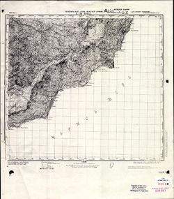
- Description:
- 1908
- Subject:
- Geographic Subject: Kislovodsk, Topical Subject: Soviet Union, and Topical Subject: Maps
- Publisher:
- НКЗ СССР Сельхозаэросъемка
- Language:
- Russian
- Date Created:
- 1941
- Identifier:
- VAC9619-000730
- Genre:
- Military Maps and Topographic Maps
- Geographic Location:
- Coordinates: 43.6667, 42.5, 44, 43
- Related URL:
- Catalog URL: https://iucat.iu.edu/catalog/5020129 and Download GeoTIFF: https://drive.google.com/open?id=1hE8Lj11I3DMGaxuNgdEk19cXKHishQi_
- Abstract:
- Modern area represented: Kislovodsk, Stavropol kray, Russia
- Call Number:
- G7000 s100 .S7 sheet K-38-2
- Caption:
- Для служебного пользования
- City:
- Кисловодск (Kislovodsk)
- Copyright Holder:
- No Copyright - United States
- Country:
- СССР (USSR)
- State/Province:
- Карачаевская автономная область (Karachay Autonomous Oblast), Орджоникидзевский край (Ordzhonikidze kray), РСФСР (RSFSR), and Кабардино-Балкарская АССР (Kaba...
- Physical Description:
- Scale: 1:100,000
- Persistent URL:
- http://purl.dlib.indiana.edu/iudl/images/VAC9619/VAC9619-000730
- Provenance:
- DMA Topographic Center, Atlasblatt, Army Map Service Library, Library of Congress Geography & Map Division, OMAHA
-
- Description:
- 1941
- Subject:
- Geographic Subject: Babayurt, Topical Subject: Maps, and Topical Subject: Soviet Union
- Publisher:
- Генеральный штаб Красной Армии
- Language:
- Russian
- Date Created:
- 1942
- Identifier:
- VAC9619-000784
- Genre:
- Topographic Maps and Military Maps
- Geographic Location:
- Coordinates: 43.3333, 46.5, 43.6667, 47
- Related URL:
- Download GeoTIFF: https://drive.google.com/open?id=1J0-KZD89YETRBJk8JXDeJgXjmkM-Bz0H and Catalog URL: https://iucat.iu.edu/catalog/5020129
- Abstract:
- Modern area represented: Babayurt, Dagestan republic, Russia
- Call Number:
- G7000 s100 .S7 sheet K-38-22
- Caption:
- Для служебного пользования
- City:
- Баба-Юрт (Baba-Yurt)
- Copyright Holder:
- No Copyright - United States
- Country:
- СССР (USSR)
- State/Province:
- Дагестанская АССР (Dagestan Autonomous Soviet Socialist Republic) and РСФСР (RSFSR)
- Physical Description:
- Scale: 1:100,000
- Persistent URL:
- http://purl.dlib.indiana.edu/iudl/images/VAC9619/VAC9619-000784
- Provenance:
- CIA Map Library, Atlasblatt
-
- Description:
- 1870
- Subject:
- Topical Subject: Soviet Union, Topical Subject: Maps, and Geographic Subject: Alagir
- Publisher:
- Генеральный штаб Красной Армии
- Language:
- Russian
- Date Created:
- 1942
- Identifier:
- VAC9619-000786
- Genre:
- Topographic Maps and Military Maps
- Geographic Location:
- Coordinates: 43, 44, 43.3333, 44.5
- Related URL:
- Download GeoTIFF: https://drive.google.com/open?id=1ipwxw4RfPnMQCVYN2bZCXjRGnhJRTiAZ and Catalog URL: https://iucat.iu.edu/catalog/5020129
- Abstract:
- Modern area represented: Alagir, North Ossetia – Alania republic, Russia
- Call Number:
- G7000 s100 .S7 sheet K-38-29
- Caption:
- Для служебного пользования
- City:
- Алагир (Alagir)
- Copyright Holder:
- No Copyright - United States
- Country:
- СССР (USSR)
- State/Province:
- Северо-Осетинская АССР (North Ossetian Autonomous Soviet Socialist Republic), Кабардино-Балкарская АССР (Kabardino-Balkar Autonomous Soviet Socialist Republi...
- Physical Description:
- Scale: 1:100,000
- Persistent URL:
- http://purl.dlib.indiana.edu/iudl/images/VAC9619/VAC9619-000786
- Provenance:
- Army Map Service Library, Geographic Names Branch, Library of Congress G & M Division
-
- Description:
- 1910
- Subject:
- Topical Subject: Soviet Union, Topical Subject: Maps, and Geographic Subject: Malka
- Publisher:
- Генеральный штаб Красной Армии
- Language:
- Russian
- Date Created:
- 1942
- Identifier:
- VAC9619-000774
- Genre:
- Topographic Maps and Military Maps
- Geographic Location:
- Coordinates: 43.6667, 43, 44, 43.5
- Related URL:
- Download GeoTIFF: https://drive.google.com/open?id=1SGbNvHRjKc5EerPHr8nhRF6X8xaL-QxT and Catalog URL: https://iucat.iu.edu/catalog/5020129
- Abstract:
- Modern area represented: Malka, Kabardino-Balkariya republic, Russia
- Call Number:
- G7000 s100 .S7 sheet K-38-3
- Caption:
- Для служебного пользования
- City:
- Малка (Malka)
- Copyright Holder:
- No Copyright - United States
- Country:
- СССР (USSR)
- State/Province:
- РСФСР (RSFSR), Кабардино-Балкарская АССР (Kabardino-Balkar Autonomous Soviet Socialist Republic), and Орджоникидзевский край (Ordzhonikidze kray)
- Physical Description:
- Scale: 1:100,000
- Persistent URL:
- http://purl.dlib.indiana.edu/iudl/images/VAC9619/VAC9619-000774
- Provenance:
- Army Map Service Library, Geographic Names Branch, Library of Congress G & M Division
-
- Description:
- 1865
- Subject:
- Geographic Subject: Vladikavkaz, Topical Subject: Soviet Union, and Topical Subject: Maps
- Publisher:
- Генеральный штаб Красной Армии
- Language:
- Russian
- Date Created:
- 1942
- Identifier:
- VAC9619-000771
- Genre:
- Military Maps and Topographic Maps
- Geographic Location:
- Coordinates: 43, 44.5, 43.3333, 45
- Related URL:
- Catalog URL: https://iucat.iu.edu/catalog/5020129 and Download GeoTIFF: https://drive.google.com/open?id=1kDKKODnPr23wD5i0h8neJQlTz_2AADEd
- Abstract:
- Modern area represented: Vladikavkaz, North Ossetia, Russia
- Call Number:
- G7000 s100 .S7 sheet K-38-30
- Caption:
- Для служебного пользования
- City:
- Орджоникидзе (Ordzhonikidze)
- Copyright Holder:
- No Copyright - United States
- Country:
- СССР (USSR)
- State/Province:
- Северо-Осетинская АССР (North Ossetian Autonomous Soviet Socialist Republic), Чечено-Ингушская АССР (Checheno-Ingush Autonomous Soviet Socialist Republic), a...
- Physical Description:
- Scale: 1:100,000
- Persistent URL:
- http://purl.dlib.indiana.edu/iudl/images/VAC9619/VAC9619-000771
- Provenance:
- DMA Topographic Center, Army Map Service Library, Library of Congress Geography & Map Division
-
- Description:
- 1941
- Subject:
- Topical Subject: Soviet Union, Geographic Subject: Sulak, and Topical Subject: Maps
- Publisher:
- Генеральный штаб Красной Армии
- Language:
- Russian
- Date Created:
- 1942
- Identifier:
- VAC9619-000823
- Genre:
- Topographic Maps and Military Maps
- Geographic Location:
- Coordinates: 43.1667, 47.5, 43.3333, 47.75
- Related URL:
- Download GeoTIFF: https://drive.google.com/open?id=1fi0Y7Zx7hJENqk7HaR288XcwIYbzqak_ and Catalog URL: https://iucat.iu.edu/catalog/5020129
- Abstract:
- Modern area represented: Sulak, Dagestan republic, Russia
- Call Number:
- G7000 s100 .S7 sheet K-38-36
- Caption:
- Для служебного пользования
- City:
- Главный Сулак (Glavniy Sulak)
- Copyright Holder:
- No Copyright - United States
- Country:
- СССР (USSR)
- State/Province:
- Дагестанская АССР (Dagestan Autonomous Soviet Socialist Republic) and РСФСР (RSFSR)
- Physical Description:
- Scale: 1:100,000
- Persistent URL:
- http://purl.dlib.indiana.edu/iudl/images/VAC9619/VAC9619-000823
- Provenance:
- DMA Topographic Center, Atlasblatt, Library of Congress Geography & Map Division, Army Map Service Library
-
- Description:
- 1926
- Subject:
- Geographic Subject: Petropavlovskiy, Topical Subject: Soviet Union, and Topical Subject: Maps
- Publisher:
- Генеральный штаб Красной Армии
- Language:
- Russian
- Date Created:
- 1942
- Identifier:
- VAC9619-000776
- Genre:
- Military Maps and Topographic Maps
- Geographic Location:
- Coordinates: 43.6667, 43.5, 44, 44
- Related URL:
- Catalog URL: https://iucat.iu.edu/catalog/5020129 and Download GeoTIFF: https://drive.google.com/open?id=1dg7f6EBuVklTPJaZtvCy_PTDJEXMZyd5
- Abstract:
- Modern area represented: Petropavlovskiy, Kabardino-Balkariya republic, Russia
- Call Number:
- G7000 s100 .S7 sheet K-38-4
- Caption:
- Для служебного пользования
- City:
- Новопавловская (Petropavlovskaya)
- Copyright Holder:
- No Copyright - United States
- Country:
- СССР (USSR)
- State/Province:
- Орджоникидзевский край (Ordzhonikidze kray), Кабардино-Балкарская АССР (Kabardino-Balkar Autonomous Soviet Socialist Republic), and РСФСР (RSFSR)
- Physical Description:
- Scale: 1:100,000
- Persistent URL:
- http://purl.dlib.indiana.edu/iudl/images/VAC9619/VAC9619-000776
- Provenance:
- DMA Topographic Center, Army Map Service Library, Library of Congress Geography & Map Division
-
- Description:
- 1925
- Subject:
- Topical Subject: Maps, Geographic Subject: Prokhladniy, and Topical Subject: Soviet Union
- Publisher:
- Генеральный штаб Красной Армии
- Language:
- Russian
- Date Created:
- 1942
- Identifier:
- VAC9619-000808
- Genre:
- Topographic Maps and Military Maps
- Geographic Location:
- Coordinates: 43.6667, 44, 44, 44.5
- Related URL:
- Download GeoTIFF: https://drive.google.com/open?id=1OjKt08J0_fPt0XbJ57tpvB64eHbCRPc1 and Catalog URL: https://iucat.iu.edu/catalog/5020129
- Abstract:
- Modern area represented: Prokhladniy, Kabardino-Balkariya republic, Russia
- Call Number:
- G7000 s100 .S7 sheet K-38-5
- Caption:
- Секретно
- City:
- Прохладный (Prokhladniy)
- Copyright Holder:
- No Copyright - United States
- Country:
- СССР (USSR)
- State/Province:
- Орджоникидзевский край (Ordzhonikidze kray), РСФСР (RSFSR), and Кабардино-Балкарская АССР (Kabardino-Balkar Autonomous Soviet Socialist Republic)
- Physical Description:
- Scale: 1:100,000
- Persistent URL:
- http://purl.dlib.indiana.edu/iudl/images/VAC9619/VAC9619-000808
- Provenance:
- DMA Topographic Center, Army Map Service Library, Library of Congress Geography & Map Division
-
- Description:
- 1927
- Subject:
- Topical Subject: Soviet Union, Geographic Subject: Mozdok, and Topical Subject: Maps
- Publisher:
- Генеральный штаб Красной Армии
- Language:
- Russian
- Date Created:
- 1942
- Identifier:
- VAC9619-000781
- Genre:
- Military Maps and Topographic Maps
- Geographic Location:
- Coordinates: 43.6667, 44.5, 44, 45
- Related URL:
- Download GeoTIFF: https://drive.google.com/open?id=1r1SWyJiKpjKXCDKEQG6P9Qc-RYOZ5cX_ and Catalog URL: https://iucat.iu.edu/catalog/5020129
- Abstract:
- Modern area represented: Mozdok, North Ossetia – Alania republic, Russia
- Call Number:
- G7000 s100 .S7 sheet K-38-6
- Caption:
- Для служебного пользования
- City:
- Моздок (Mozdok)
- Copyright Holder:
- No Copyright - United States
- Country:
- СССР (USSR)
- State/Province:
- Орджоникидзевский край (Ordzhonikidze kray), Кабардино-Балкарская АССР (Kabardino-Balkar Autonomous Soviet Socialist Republic), РСФСР (RSFSR), and Чечено-Инг...
- Physical Description:
- Scale: 1:100,000
- Persistent URL:
- http://purl.dlib.indiana.edu/iudl/images/VAC9619/VAC9619-000781
- Provenance:
- Army Map Service Library, Geographic Names Branch, Library of Congress G & M Division
-
- Description:
- 1928
- Subject:
- Geographic Subject: Ishcherskaya, Topical Subject: Maps, and Topical Subject: Soviet Union
- Publisher:
- Генеральный штаб Красной Армии
- Language:
- Russian
- Date Created:
- 1942
- Identifier:
- VAC9619-000713
- Genre:
- Military Maps and Topographic Maps
- Geographic Location:
- Coordinates: 43.6667, 45, 44, 45.5
- Related URL:
- Catalog URL: https://iucat.iu.edu/catalog/5020129 and Download GeoTIFF: https://drive.google.com/open?id=1FvJwKmJFKaVdSLxaBo8WClBaKfF26Pxc
- Abstract:
- Modern area represented: Ishcherskaya, Chechnya, Russia
- Call Number:
- G7000 s100 .S7 sheet K-38-7
- Caption:
- Для служебного пользования
- City:
- Ищерская (Ishcherskaya)
- Copyright Holder:
- No Copyright - United States
- Country:
- СССР (USSR)
- State/Province:
- Орджоникидзевский край (Ordzhonikidze kray), Чечено-Ингушская АССР (Checheno-Ingush Autonomous Soviet Socialist Republic), and РСФСР (RSFSR)
- Physical Description:
- Scale: 1:100,000
- Persistent URL:
- http://purl.dlib.indiana.edu/iudl/images/VAC9619/VAC9619-000713
- Provenance:
- Army Map Service Library, Geographic Names Branch, Library of Congress G & M Division
-
- Description:
- 1906
- Subject:
- Geographic Subject: Hunchun, Topical Subject: Soviet Union, and Topical Subject: Maps
- Publisher:
- Управление военных топографов РККА
- Language:
- Russian
- Date Created:
- 1933
- Identifier:
- VAC9619-000914
- Genre:
- Topographic Maps and Military Maps
- Geographic Location:
- Coordinates: 42.6667, 130, 43, 130.5
- Related URL:
- Download GeoTIFF: https://drive.google.com/open?id=14YXbAZgngEEXJeyyh0_6PJ45RyfdxAgg and Catalog URL: https://iucat.iu.edu/catalog/5020129
- Abstract:
- Modern area represented: Hunchun, Jilin province, China
- Call Number:
- G7000 s100 .S7 sheet K-52-45
- Caption:
- Не подлежит оглашению
- City:
- Хунчун (Hunchun)
- Copyright Holder:
- No Copyright - United States
- Country:
- СССР (USSR) and Корея (Korea)
- State/Province:
- Дальневосточный край (Far Eastern kray), Маньчжурия (Manchuria), and РСФСР (RSFSR)
- Physical Description:
- Scale: 1:100,000
- Persistent URL:
- http://purl.dlib.indiana.edu/iudl/images/VAC9619/VAC9619-000914
- Provenance:
- DMA Topographic Center, Army Map Service Library, OMAHA, Library of Congress Geography & Map Division
-
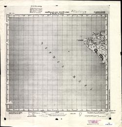
- Description:
- 1935
- Subject:
- Topical Subject: Soviet Union, Topical Subject: Maps, and Geographic Subject: Sergeyevka
- Publisher:
- Управление военных топографов РККА
- Language:
- Russian
- Identifier:
- VAC9619-000822
- Genre:
- Military Maps and Topographic Maps
- Geographic Location:
- Coordinates: 43.3333, 133, 43.6667, 133.5
- Related URL:
- Download GeoTIFF: https://drive.google.com/open?id=1CRxpKntUT0SQjGYFGsZAgqrl0lOMN9eg and Catalog URL: https://iucat.iu.edu/catalog/5020129
- Abstract:
- Modern area represented: Sergeyevka, Primorskiy (Maritime) kray, Russia
- Call Number:
- G7000 s100 .S7 sheet K-53-15
- Caption:
- Не подлежит оглашению
- City:
- Сергеевка (Sergeyevka)
- Copyright Holder:
- No Copyright - United States
- Country:
- СССР (USSR)
- State/Province:
- РСФСР (RSFSR) and Дальневосточный край (Far Eastern kray)
- Physical Description:
- Scale: 1:100,000
- Persistent URL:
- http://purl.dlib.indiana.edu/iudl/images/VAC9619/VAC9619-000822
- Provenance:
- DMA Topographic Center, Library of Congress G & M Division, Army Map Service Library, Atlasblatt
-
- Description:
- 1913
- Subject:
- Topical Subject: Maps, Topical Subject: Soviet Union, and Geographic Subject: Partizansk
- Publisher:
- Управление военных топографов РККА
- Language:
- Russian
- Date Created:
- 1934
- Identifier:
- VAC9619-000811
- Genre:
- Topographic Maps and Military Maps
- Geographic Location:
- Coordinates: 43, 133, 43.3333, 133.5
- Related URL:
- Catalog URL: https://iucat.iu.edu/catalog/5020129 and Download GeoTIFF: https://drive.google.com/open?id=1R7GQuqPSC31N6DmuMyrjjbi0qENHsXFB
- Abstract:
- Modern area represented: Partizansk, Primorskiy (Maritime) kray, Russia
- Call Number:
- G7000 s100 .S7 sheet K-53-27
- Caption:
- Не подлежит оглашению
- City:
- Сучан (Suchan)
- Copyright Holder:
- No Copyright - United States
- Country:
- СССР (USSR)
- State/Province:
- РСФСР (RSFSR) and Дальневосточный край (Far Eastern kray)
- Physical Description:
- Scale: 1:100,000
- Persistent URL:
- http://purl.dlib.indiana.edu/iudl/images/VAC9619/VAC9619-000811
- Provenance:
- DMA Topographic Center, Army Map Service Library, Library of Congress Geography & Map Division, Atlasblatt
-
- Description:
- 1895
- Subject:
- Topical Subject: Maps, Topical Subject: Soviet Union, Geographic Subject: Republic of Crimea, and Geographic Subject: Yevpatoriya
- Publisher:
- Генеральный штаб Красной Армии
- Language:
- Russian
- Date Created:
- 1941
- Identifier:
- VAC9619-001955
- Genre:
- Topographic Maps and Military Maps
- Geographic Location:
- Coordinates: 45, 33, 45.3333, 33.5
- Related URL:
- Download GeoTIFF: https://drive.google.com/open?id=1BtkwQn0L-XQPkON9n_c9ainj7EtEYvHh and Catalog URL: https://iucat.iu.edu/catalog/5020129
- Abstract:
- Modern area represented: Евпатория (Yevpatoriya), Republic of Crimea, Ukraine
- Call Number:
- G7000 s100 .S7 sheet L-36-103
- Caption:
- Для служебного пользования
- City:
- Евпатория (Yevpatoriya)
- Copyright Holder:
- No Copyright - United States
- Country:
- СССР (USSR)
- State/Province:
- РСФСР (RSFSR) and Крымская АССР (Crimean Autonomous Soviet Socialist Republic)
- Physical Description:
- Scale: 1:100,000
- Persistent URL:
- http://purl.dlib.indiana.edu/iudl/images/VAC9619/VAC9619-001955
- Provenance:
- DMA Topographic Center, OMAHA
-
- Description:
- 1895
- Subject:
- Geographic Subject: Republic of Crimea, Geographic Subject: Saki, Topical Subject: Soviet Union, and Topical Subject: Maps
- Publisher:
- Генеральный штаб Красной Армии
- Language:
- Russian
- Date Created:
- 1941
- Identifier:
- VAC9619-001956
- Genre:
- Topographic Maps and Military Maps
- Geographic Location:
- Coordinates: 45, 33.5, 45.3333, 34
- Related URL:
- Download GeoTIFF: https://drive.google.com/open?id=1KeZQMnq0svWW8sbbr2gRu_IXfdHE5Zod and Catalog URL: https://iucat.iu.edu/catalog/5020129
- Abstract:
- Modern area represented: Саки (Saki), Republic of Crimea, Ukraine
- Call Number:
- G7000 s100 .S7 sheet L-36-104
- Caption:
- Для cлужебного пользования
- City:
- Саки (Saki)
- Copyright Holder:
- No Copyright - United States
- Country:
- СССР (USSR)
- State/Province:
- РСФСР (RSFSR)
- Physical Description:
- Scale: 1:100,000
- Persistent URL:
- http://purl.dlib.indiana.edu/iudl/images/VAC9619/VAC9619-001956
- Provenance:
- CIA Map Library
-
- Description:
- 1894
- Subject:
- Topical Subject: Maps, Topical Subject: Soviet Union, Geographic Subject: Zuya, and Geographic Subject: Republic of Crimea
- Publisher:
- Генеральный штаб Красной Армии
- Language:
- Russian
- Date Created:
- 1941
- Identifier:
- VAC9619-001957
- Genre:
- Military Maps and Topographic Maps
- Geographic Location:
- Coordinates: 45, 34, 45.3333, 34.5
- Related URL:
- Catalog URL: https://iucat.iu.edu/catalog/5020129 and Download GeoTIFF: https://drive.google.com/open?id=1OnZgZa5AYScso5JZKHdHoMlUXdIKTLCN
- Abstract:
- Modern area represented: Зуя (Zuya), Republic of Crimea, Ukraine
- Call Number:
- G7000 s100 .S7 sheet L-36-105
- Caption:
- Для cлужебного пользования
- City:
- Зуя (Zuya)
- Copyright Holder:
- No Copyright - United States
- Country:
- СССР (USSR)
- State/Province:
- РСФСР (RSFSR) and Крымская АССР (Crimean Autonomous Soviet Socialist Republic)
- Physical Description:
- Scale: 1:100,000
- Persistent URL:
- http://purl.dlib.indiana.edu/iudl/images/VAC9619/VAC9619-001957
- Provenance:
- CIA Map Library
-
- Description:
- 1894
- Subject:
- Geographic Subject: Belogorsk, Geographic Subject: Republic of Crimea, Topical Subject: Soviet Union, and Topical Subject: Maps
- Publisher:
- Генеральный штаб Красной Армии
- Language:
- Russian
- Date Created:
- 1941
- Identifier:
- VAC9619-001958
- Genre:
- Topographic Maps and Military Maps
- Geographic Location:
- Coordinates: 45, 34.5, 45.3333, 35
- Related URL:
- Download GeoTIFF: https://drive.google.com/open?id=1nKMezCPbbFtDGWrByhCoLFbMRGzI6CvP and Catalog URL: https://iucat.iu.edu/catalog/5020129
- Abstract:
- Modern area represented: Карасубазар (Karasubazar), Republic of Crimea, Ukraine
- Call Number:
- G7000 s100 .S7 sheet L-36-106
- Caption:
- Для cлужебного пользования
- City:
- Карасубазар (Karasubazar)
- Copyright Holder:
- No Copyright - United States
- Country:
- СССР (USSR)
- State/Province:
- Крымская АССР (Crimean Autonomous Soviet Socialist Republic) and РСФСР (RSFSR)
- Physical Description:
- Scale: 1:100,000
- Persistent URL:
- http://purl.dlib.indiana.edu/iudl/images/VAC9619/VAC9619-001958
- Provenance:
- DMA Topographic Center
-
- Description:
- 1889
- Subject:
- Topical Subject: Maps, Geographic Subject: Republic of Crimea, Topical Subject: Soviet Union, and Geographic Subject: Feodosiya
- Publisher:
- Генеральный штаб Красной Армии
- Language:
- Russian
- Date Created:
- 1941
- Identifier:
- VAC9619-001959
- Genre:
- Military Maps and Topographic Maps
- Geographic Location:
- Coordinates: 45, 35, 45.3333, 35.5
- Related URL:
- Download GeoTIFF: https://drive.google.com/open?id=1zw4CQzIiaF0hYJlTRjCytykSghirEYb2 and Catalog URL: https://iucat.iu.edu/catalog/5020129
- Abstract:
- Modern area represented: Феодосия (Feodosiya), Republic of Crimea, Ukraine
- Call Number:
- G7000 s100 .S7 sheet L-36-107
- Caption:
- Для cлужебного пользования
- City:
- Феодосия (Feodosiya)
- Copyright Holder:
- No Copyright - United States
- Country:
- СССР (USSR)
- State/Province:
- РСФСР (RSFSR) and Крымская АССР (Crimean Autonomous Soviet Socialist Republic)
- Physical Description:
- Scale: 1:100,000
- Persistent URL:
- http://purl.dlib.indiana.edu/iudl/images/VAC9619/VAC9619-001959
- Provenance:
- DMA Topographic Center
-
- Description:
- 1889
- Subject:
- Geographic Subject: Lenino, Geographic Subject: Republic of Crimea, Topical Subject: Maps, and Topical Subject: Soviet Union
- Publisher:
- Генеральный штаб Красной Армии
- Language:
- Russian
- Date Created:
- 1941
- Identifier:
- VAC9619-001961
- Genre:
- Military Maps and Topographic Maps
- Geographic Location:
- Coordinates: 45, 35.5, 45.3333, 36
- Related URL:
- Catalog URL: https://iucat.iu.edu/catalog/5020129 and Download GeoTIFF: https://drive.google.com/file/d/1F8w9d0KgUCxo4OSUz7aU9WcBWB-3VFWe/view?usp=sharing
- Abstract:
- Modern area represented: Ленино (Lenino), Republic of Crimea, Ukraine
- Call Number:
- G7000 s100 .S7 sheet L-36-108
- Caption:
- Для cлужебного пользования
- City:
- Семь Колодезей (Semʹ Kolodezeĭ)
- Copyright Holder:
- No Copyright - United States
- Country:
- СССР (USSR)
- State/Province:
- РСФСР (RSFSR) and Крымская АССР (Crimean Autonomous Soviet Socialist Republic)
- Physical Description:
- Scale: 1:100,000
- Persistent URL:
- http://purl.dlib.indiana.edu/iudl/images/VAC9619/VAC9619-001961
- Provenance:
- CIA Map Library
-
- Description:
- 1889
- Subject:
- Topical Subject: Maps, Topical Subject: Soviet Union, Geographic Subject: Republic of Crimea, and Geographic Subject: Lenino
- Publisher:
- Генеральный штаб Красной Армии
- Language:
- Russian
- Date Created:
- 1941
- Identifier:
- VAC9619-001960
- Genre:
- Topographic Maps and Military Maps
- Geographic Location:
- Coordinates: 45, 35.5, 45.3333, 36
- Related URL:
- Catalog URL: https://iucat.iu.edu/catalog/5020129 and Download GeoTIFF: https://drive.google.com/open?id=1qSuczLfm0jn5nGPeX25LeOWVuRiIlhhe
- Abstract:
- Modern area represented: Ленино (Lenino), Republic of Crimea, Ukraine
- Call Number:
- G7000 s100 .S7 sheet L-36-108
- Caption:
- Для cлужебного пользования
- City:
- Семь Колодезей (Semʹ Kolodezeĭ)
- Copyright Holder:
- No Copyright - United States
- Country:
- СССР (USSR)
- State/Province:
- РСФСР (RSFSR) and Крымская АССР (Crimean Autonomous Soviet Socialist Republic)
- Physical Description:
- Scale: 1:100,000
- Persistent URL:
- http://purl.dlib.indiana.edu/iudl/images/VAC9619/VAC9619-001960
- Provenance:
- CIA Map Library
-
- Description:
- 1889
- Subject:
- Geographic Subject: Republic of Crimea, Geographic Subject: Bakhchisaray, Topical Subject: Maps, and Topical Subject: Soviet Union
- Publisher:
- Генеральный штаб Красной Армии
- Language:
- Russian
- Date Created:
- 1941
- Identifier:
- VAC9619-001962
- Genre:
- Topographic Maps and Military Maps
- Geographic Location:
- Coordinates: 44.6667, 33.5, 45, 34
- Related URL:
- Download GeoTIFF: https://drive.google.com/open?id=1DfDXkMyieH7JsBdvMuTRR8d3wYawQcd9 and Catalog URL: https://iucat.iu.edu/catalog/5020129
- Abstract:
- Modern area represented: Bakhchisaray (Bakhchisaray), Republic of Crimea, Ukraine
- Call Number:
- G7000 s100 .S7 sheet L-36-116
- Caption:
- Для cлужебного пользования
- City:
- Bakhchisaray (Bakhchisaray)
- Copyright Holder:
- No Copyright - United States
- Country:
- СССР (USSR)
- State/Province:
- РСФСР (RSFSR) and Крымская АССР (Crimean Autonomous Soviet Socialist Republic)
- Physical Description:
- Scale: 1:100,000
- Persistent URL:
- http://purl.dlib.indiana.edu/iudl/images/VAC9619/VAC9619-001962
- Provenance:
- CIA Map Library
-
- Description:
- 1889
- Subject:
- Topical Subject: Maps, Geographic Subject: Republic of Crimea, Topical Subject: Soviet Union, and Geographic Subject: Simferopol
- Publisher:
- Генеральный штаб Красной Армии
- Language:
- Russian
- Date Created:
- 1941
- Identifier:
- VAC9619-001963
- Genre:
- Topographic Maps and Military Maps
- Geographic Location:
- Coordinates: 44.6667, 34, 45, 34.5
- Related URL:
- Download GeoTIFF: https://drive.google.com/open?id=1TOUI0x_hdHUWzPPKcEX-0cHUegwFWhCx and Catalog URL: https://iucat.iu.edu/catalog/5020129
- Abstract:
- Modern area represented: Симферополь (Simferopol), Republic of Crimea, Ukraine
- Call Number:
- G7000 s100 .S7 sheet L-36-117
- Caption:
- Для cлужебного пользования
- City:
- Симферополь (Simferopol)
- Copyright Holder:
- No Copyright - United States
- Country:
- СССР (USSR)
- State/Province:
- Крымская АССР (Crimean Autonomous Soviet Socialist Republic) and РСФСР (RSFSR)
- Physical Description:
- Scale: 1:100,000
- Persistent URL:
- http://purl.dlib.indiana.edu/iudl/images/VAC9619/VAC9619-001963
- Provenance:
- CIA Map Library
-
- Description:
- 1889
- Subject:
- Topical Subject: Maps, Topical Subject: Soviet Union, Geographic Subject: Republic of Crimea, and Geographic Subject: Simferopol
- Publisher:
- Генеральный штаб Красной Армии
- Language:
- Russian
- Date Created:
- 1941
- Identifier:
- VAC9619-001964
- Genre:
- Military Maps and Topographic Maps
- Geographic Location:
- Coordinates: 44.6667, 34, 45, 34.5
- Related URL:
- Catalog URL: https://iucat.iu.edu/catalog/5020129 and Download GeoTIFF: https://drive.google.com/file/d/1amvhrChXpoTfj7psOh9J6iw00E8WWa7q/view?usp=sharing
- Abstract:
- Modern area represented: Simferopol, Republic of Crimea, Ukraine
- Call Number:
- G7000 s100 .S7 sheet L-36-117
- Caption:
- Для служебного пользования
- City:
- Симферополь (Simferopol)
- Copyright Holder:
- No Copyright - United States
- Country:
- СССР (USSR)
- State/Province:
- Крымская АССР (Crimean Autonomous Soviet Socialist Republic) and РСФСР (RSFSR)
- Physical Description:
- Scale: 1:100,000
- Persistent URL:
- http://purl.dlib.indiana.edu/iudl/images/VAC9619/VAC9619-001964
- Provenance:
- DMA Topographic Center, Army Map Service Library
-
- Description:
- 1893
- Subject:
- Topical Subject: Maps, Geographic Subject: Republic of Crimea, Topical Subject: Soviet Union, and Geographic Subject: Sudak
- Publisher:
- Генеральный штаб Красной Армии
- Language:
- Russian
- Date Created:
- 1941
- Identifier:
- VAC9619-001965
- Genre:
- Military Maps and Topographic Maps
- Geographic Location:
- Coordinates: 44.6667, 34.5, 45, 35
- Related URL:
- Catalog URL: https://iucat.iu.edu/catalog/5020129 and Download GeoTIFF: https://drive.google.com/open?id=1GhztGrCrZpnhgPiIlhQl9-H8NXi_gHr3
- Abstract:
- Modern area represented: Sudak, Republic of Crimea, Ukraine
- Call Number:
- G7000 s100 .S7 sheet L-36-118
- Caption:
- Для служебного пользования
- City:
- Судак (Sudak)
- Copyright Holder:
- No Copyright - United States
- Country:
- СССР (USSR)
- State/Province:
- Крымская АССР (Crimean Autonomous Soviet Socialist Republic) and РСФСР (RSFSR)
- Physical Description:
- Scale: 1:100,000
- Persistent URL:
- http://purl.dlib.indiana.edu/iudl/images/VAC9619/VAC9619-001965
- Provenance:
- CIA Map Library
-
- Description:
- 1886
- Subject:
- Topical Subject: Soviet Union, Geographic Subject: Republic of Crimea, Geographic Subject: Kozacha Bukhta, and Topical Subject: Maps
- Publisher:
- Генеральный штаб Красной Армии
- Language:
- Russian
- Date Created:
- 1941
- Identifier:
- VAC9619-001966
- Genre:
- Military Maps and Topographic Maps
- Geographic Location:
- Coordinates: 44.3333, 33, 44.6667, 33.5
- Related URL:
- Catalog URL: https://iucat.iu.edu/catalog/5020129 and Download GeoTIFF: https://drive.google.com/open?id=1rTxCetecx0VLFlLfe6F9Oq1Ke8pfHb3y
- Abstract:
- Modern area represented: Козача Бухта (Kozacha Bukhta), Republic of Crimea, Ukraine
- Call Number:
- G7000 s100 .S7 sheet L-36-127
- Caption:
- Для cлужебного пользования
- City:
- Бух. Казачья (Bukh. Kazachʹya)
- Copyright Holder:
- No Copyright - United States
- Country:
- СССР (USSR)
- State/Province:
- РСФСР (RSFSR) and Крымская АССР (Crimean Autonomous Soviet Socialist Republic)
- Physical Description:
- Scale: 1:100,000
- Persistent URL:
- http://purl.dlib.indiana.edu/iudl/images/VAC9619/VAC9619-001966
- Provenance:
- CIA Map Library
-
- Description:
- 1886
- Subject:
- Geographic Subject: Republic of Crimea, Topical Subject: Soviet Union, Topical Subject: Maps, and Geographic Subject: Sevastopolʹ
- Publisher:
- Генеральный штаб Красной Армии
- Language:
- Russian
- Date Created:
- 1941
- Identifier:
- VAC9619-001967
- Genre:
- Topographic Maps and Military Maps
- Geographic Location:
- Coordinates: 44.3333, 33.5, 44.6667, 34
- Related URL:
- Catalog URL: https://iucat.iu.edu/catalog/5020129 and Download GeoTIFF: https://drive.google.com/open?id=19Qph3otPZ3oxM7TayXAtAFPDKXxzx8mM
- Abstract:
- Modern area represented: Севастополь (Sevastopolʹ), Republic of Crimea, Ukraine
- Call Number:
- G7000 s100 .S7 sheet L-36-128
- Caption:
- Для cлужебного пользования
- City:
- Севастополь (Sevastopolʹ)
- Copyright Holder:
- No Copyright - United States
- Country:
- СССР (USSR)
- State/Province:
- Крымская АССР (Crimean Autonomous Soviet Socialist Republic) and РСФСР (RSFSR)
- Physical Description:
- Scale: 1:100,000
- Persistent URL:
- http://purl.dlib.indiana.edu/iudl/images/VAC9619/VAC9619-001967
- Provenance:
- CIA Map Library
-
- Description:
- 1889
- Subject:
- Topical Subject: Soviet Union, Geographic Subject: Yalta, Topical Subject: Maps, and Geographic Subject: Republic of Crimea
- Publisher:
- Генеральный штаб Красной Армии
- Language:
- Russian
- Date Created:
- 1941
- Identifier:
- VAC9619-001968
- Genre:
- Military Maps and Topographic Maps
- Geographic Location:
- Coordinates: 44.3333, 34, 44.6667, 34.5
- Related URL:
- Download GeoTIFF: https://drive.google.com/open?id=1bqnvue1x6vK7NQBgS7rVUAY7TfqiMxJ1 and Catalog URL: https://iucat.iu.edu/catalog/5020129
- Abstract:
- Modern area represented: Ялта (Yalta), Republic of Crimea, Ukraine
- Call Number:
- G7000 s100 .S7 sheet L-36-129
- Caption:
- Для cлужебного пользования
- City:
- Ялта (Yalta)
- Copyright Holder:
- No Copyright - United States
- Country:
- СССР (USSR)
- State/Province:
- РСФСР (RSFSR) and Крымская АССР (Crimean Autonomous Soviet Socialist Republic)
- Physical Description:
- Scale: 1:100,000
- Persistent URL:
- http://purl.dlib.indiana.edu/iudl/images/VAC9619/VAC9619-001968
- Provenance:
- CIA Map Library
-
- Description:
- 1933
- Subject:
- Geographic Subject: Hromivka, Topical Subject: Soviet Union, and Topical Subject: Maps
- Publisher:
- Генеральный штаб Красной Армии
- Language:
- Russian
- Date Created:
- 1941
- Identifier:
- VAC9619-001923
- Genre:
- Topographic Maps and Military Maps
- Geographic Location:
- Coordinates: 46, 34, 46.3333, 34.5
- Related URL:
- Download GeoTIFF: https://drive.google.com/open?id=1sOMPSRT5vHzGSJy5FqPqnkWmkwqYR5YH and Catalog URL: https://iucat.iu.edu/catalog/5020129
- Abstract:
- Modern area represented: Hromivka, Kherson oblast, Ukraine
- Call Number:
- G7000 s100 .S7 sheet L-36-69
- Caption:
- Для служебного пользования
- City:
- Громовка (Gromovka)
- Copyright Holder:
- No Copyright - United States
- Country:
- СССР (USSR)
- State/Province:
- Украинская ССР (Ukrainian Soviet Socialist Republic), Крымская АССР (Crimean Autonomous Soviet Socialist Republic), Запорожская область (Zaporizhia oblast), ...
- Physical Description:
- Scale: 1:100,000
- Persistent URL:
- http://purl.dlib.indiana.edu/iudl/images/VAC9619/VAC9619-001923
- Provenance:
- CIA Map Library
-
- Description:
- 1899
- Subject:
- Topical Subject: Soviet Union, Topical Subject: Maps, and Geographic Subject: Slavne
- Publisher:
- Генеральный штаб Красной Армии
- Language:
- Russian
- Date Created:
- 1941
- Identifier:
- VAC9619-001927
- Genre:
- Military Maps and Topographic Maps
- Geographic Location:
- Coordinates: 45.6667, 33, 46, 33.5
- Related URL:
- Catalog URL: https://iucat.iu.edu/catalog/5020129 and Download GeoTIFF: https://drive.google.com/open?id=18d2YDe94-hXEd9X6UYYnpuKQUZoK9pxF
- Abstract:
- Modern area represented: Slavne, Republic of Crimea, Ukraine
- Call Number:
- G7000 s100 .S7 sheet L-36-79
- Caption:
- Для cлужебного пользования
- City:
- Бакал (Bakal)
- Copyright Holder:
- No Copyright - United States
- Country:
- СССР (USSR)
- State/Province:
- РСФСР (RSFSR) and Крымская АССР (Crimean Autonomous Soviet Socialist Republic)
- Physical Description:
- Scale: 1:100,000
- Persistent URL:
- http://purl.dlib.indiana.edu/iudl/images/VAC9619/VAC9619-001927
- Provenance:
- CIA Map Library
-
- Description:
- 1899
- Subject:
- Geographic Subject: Slavne, Geographic Subject: Republic of Crimea, Topical Subject: Maps, and Topical Subject: Soviet Union
- Publisher:
- Генеральный штаб Красной Армии
- Language:
- Russian
- Date Created:
- 1941
- Identifier:
- VAC9619-001940
- Genre:
- Military Maps and Topographic Maps
- Geographic Location:
- Coordinates: 45.6667, 33, 46, 33.5
- Related URL:
- Catalog URL: https://iucat.iu.edu/catalog/5020129 and Download GeoTIFF: https://drive.google.com/file/d/1nGp198pPjK2vUsSj1YE61BynPsFRwexk/view?usp=sharing
- Abstract:
- Modern area represented: Славне (Slavne), Republic of Crimea, Ukraine
- Call Number:
- G7000 s100 .S7 sheet L-36-79
- Caption:
- Для cлужебного пользования
- City:
- Бакал (Bakal)
- Copyright Holder:
- No Copyright - United States
- Country:
- СССР (USSR)
- State/Province:
- Крымская АССР (Crimean Autonomous Soviet Socialist Republic) and РСФСР (RSFSR)
- Physical Description:
- Scale: 1:100,000
- Persistent URL:
- http://purl.dlib.indiana.edu/iudl/images/VAC9619/VAC9619-001940
- Provenance:
- DMA Topographic Center
-
- Description:
- 1900
- Subject:
- Geographic Subject: Krasnoperekopsk, Topical Subject: Soviet Union, Geographic Subject: Republic of Crimea, and Topical Subject: Maps
- Publisher:
- Генеральный штаб Красной Армии
- Language:
- Russian
- Date Created:
- 1941
- Identifier:
- VAC9619-001942
- Genre:
- Military Maps and Topographic Maps
- Geographic Location:
- Coordinates: 45.6667, 33.5, 46, 34
- Related URL:
- Catalog URL: https://iucat.iu.edu/catalog/5020129 and Download GeoTIFF: https://drive.google.com/open?id=19vuJKNo-7ztrGdjs5V7oHyn0x8claJ8V
- Abstract:
- Modern area represented: Красноперекопск (Krasnoperekopsk), Republic of Crimea, Ukraine
- Call Number:
- G7000 s100 .S7 sheet L-36-80
- Caption:
- Для cлужебного пользования
- City:
- Красноперекопск (Krasnoperekopsk)
- Copyright Holder:
- No Copyright - United States
- Country:
- СССР (USSR)
- State/Province:
- РСФСР (RSFSR) and Крымская АССР (Crimean Autonomous Soviet Socialist Republic)
- Physical Description:
- Scale: 1:100,000
- Persistent URL:
- http://purl.dlib.indiana.edu/iudl/images/VAC9619/VAC9619-001942
- Provenance:
- CIA Map Library
-
- Description:
- 1903
- Subject:
- Geographic Subject: Dzhankoi, Topical Subject: Soviet Union, and Topical Subject: Maps
- Publisher:
- Генеральный штаб Красной Армии
- Language:
- Russian
- Date Created:
- 1941
- Identifier:
- VAC9619-001943
- Genre:
- Topographic Maps and Military Maps
- Geographic Location:
- Coordinates: 45.6667, 34, 46, 34.5
- Related URL:
- Download GeoTIFF: https://drive.google.com/open?id=1Uezem1DTHm_K_ar57W6lultAdVkJlsj1 and Catalog URL: https://iucat.iu.edu/catalog/5020129
- Abstract:
- Modern area represented: Dzhankoi, Republic of Crimea, Ukraine
- Call Number:
- G7000 s100 .S7 sheet L-36-81
- Caption:
- Для cлужебного пользования
- City:
- Джанкой (Dzhankoi)
- Copyright Holder:
- No Copyright - United States
- Country:
- СССР (USSR)
- State/Province:
- Крымская АССР (Crimean Autonomous Soviet Socialist Republic), РСФСР (RSFSR), and Украинская ССР (Ukrainian Soviet Socialist Republic)
- Physical Description:
- Scale: 1:100,000
- Persistent URL:
- http://purl.dlib.indiana.edu/iudl/images/VAC9619/VAC9619-001943
- Provenance:
- G000-30
-

- Description:
- 1903
- Subject:
- Geographic Subject: Dzhankoi, Topical Subject: Soviet Union, Topical Subject: Maps, and Geographic Subject: Republic of Crimea
- Publisher:
- Генеральный штаб Красной Армии
- Language:
- Russian
- Date Created:
- 1941
- Identifier:
- VAC9619-001944
- Genre:
- Military Maps and Topographic Maps
- Geographic Location:
- Coordinates: 45.6667, 34, 46, 34.5
- Related URL:
- Download GeoTIFF: https://drive.google.com/file/d/1IYgb5gSCs_Mlieru0V4EbduHgPq3hkzr/view?usp=sharing and Catalog URL: https://iucat.iu.edu/catalog/5020129
- Abstract:
- Modern area represented: Джанкой (Dzhankoi), Republic of Crimea, Ukraine
- Call Number:
- G7000 s100 .S7 sheet L-36-81
- Caption:
- Для cлужебного пользования
- City:
- Джанкой (Dzhankoi)
- Copyright Holder:
- No Copyright - United States
- Country:
- СССР (USSR)
- State/Province:
- Украинская ССР (Ukrainian Soviet Socialist Republic), РСФСР (RSFSR), and Крымская АССР (Crimean Autonomous Soviet Socialist Republic)
- Physical Description:
- Scale: 1:100,000
- Persistent URL:
- http://purl.dlib.indiana.edu/iudl/images/VAC9619/VAC9619-001944
- Provenance:
- DMA Topographic Center
-
- Description:
- 1904
- Subject:
- Topical Subject: Maps, Geographic Subject: Republic of Crimea, Topical Subject: Soviet Union, and Geographic Subject: Strilkove
- Publisher:
- Генеральный штаб Красной Армии
- Language:
- Russian
- Date Created:
- 1939
- Identifier:
- VAC9619-001945
- Genre:
- Topographic Maps and Military Maps
- Geographic Location:
- Coordinates: 45.6667, 34.5, 46, 35
- Related URL:
- Download GeoTIFF: https://drive.google.com/open?id=1J3kf3_BFpbswDiTYCjqH2cU11SoWbI1E and Catalog URL: https://iucat.iu.edu/catalog/5020129
- Abstract:
- Modern area represented: Стрілкове (Strilkove), Republic of Crimea, Ukraine
- Call Number:
- G7000 s100 .S7 sheet L-36-82
- Caption:
- Для cлужебного пользования
- City:
- Чокрак (CHokrak)
- Copyright Holder:
- No Copyright - United States
- Country:
- СССР (USSR)
- State/Province:
- Крымская АССР (Crimean Autonomous Soviet Socialist Republic), Украинская ССР (Ukrainian Soviet Socialist Republic), and РСФСР (RSFSR)
- Physical Description:
- Scale: 1:100,000
- Persistent URL:
- http://purl.dlib.indiana.edu/iudl/images/VAC9619/VAC9619-001945
- Provenance:
- DMA Topographic Center
-
- Description:
- 1940
- Subject:
- Topical Subject: Maps, Topical Subject: Soviet Union, and Geographic Subject: Peredmistne
- Publisher:
- Генеральный штаб Красной Армии
- Language:
- Russian
- Date Created:
- 1942
- Identifier:
- VAC9619-000123
- Genre:
- Topographic Maps and Military Maps
- Geographic Location:
- Coordinates: 45.8333, 34.5, 46, 34.75
- Related URL:
- https://drive.google.com/open?id=10x2abEgI_sYvWJWaepRIpxG5c1jbwXZ_, Catalog URL: http://iucat.iu.edu/catalog/5020131, and Download GeoTIFF: https://drive.goo...
- Abstract:
- Modern area represented: Peredmistne, Republic of Crimea, Ukraine
- Call Number:
- G7000 s50 .S68 sheet L-36-82-A
- Caption:
- Для служебного пользования
- City:
- Тюп-Джанкой (Tyup-Dzhankoy)
- Copyright Holder:
- No Copyright - United States
- Country:
- СССР (USSR)
- State/Province:
- Запорожская область (Zaporizhia oblast), Украинская ССР (Ukrainian Soviet Socialist Republic), Крымская АССР (Crimean Autonomous Soviet Socialist Republic), ...
- Physical Description:
- Scale: 1:50,000
- Persistent URL:
- http://purl.dlib.indiana.edu/iudl/images/VAC9619/VAC9619-000123
- Provenance:
- DMA Topographic Center, Army Map Service Library, OMAHA, Library of Congress Geography & Map Division
-

- Description:
- 1898
- Subject:
- Geographic Subject: Chernomorskoye, Topical Subject: Maps, Topical Subject: Soviet Union, and Geographic Subject: Republic of Crimea
- Publisher:
- Генеральный штаб Красной Армии
- Language:
- Russian
- Date Created:
- 1941
- Identifier:
- VAC9619-001947
- Genre:
- Military Maps and Topographic Maps
- Geographic Location:
- Coordinates: 45.3333, 32.5, 45.6667, 33
- Related URL:
- Catalog URL: https://iucat.iu.edu/catalog/5020129 and Download GeoTIFF: https://drive.google.com/file/d/1rB0AANSU20H5BnrnPPEYkyBHQ4HUd6BX/view?usp=sharing
- Abstract:
- Modern area represented: Черноморское (Chernomorskoye), Republic of Crimea, Ukraine
- Call Number:
- G7000 s100 .S7 sheet L-36-90
- Caption:
- Для cлужебного пользования
- City:
- Ак-Мечеть (Ak-Mechetʹ)
- Copyright Holder:
- No Copyright - United States
- Country:
- СССР (USSR)
- State/Province:
- Крымская АССР (Crimean Autonomous Soviet Socialist Republic) and РСФСР (RSFSR)
- Physical Description:
- Scale: 1:100,000
- Persistent URL:
- http://purl.dlib.indiana.edu/iudl/images/VAC9619/VAC9619-001947
- Provenance:
- DMA Topographic Center
-
- Description:
- 1898
- Subject:
- Topical Subject: Soviet Union, Geographic Subject: Republic of Crimea, Topical Subject: Maps, and Geographic Subject: Chernomorskoye
- Publisher:
- Генеральный штаб Красной Армии
- Language:
- Russian
- Date Created:
- 1941
- Identifier:
- VAC9619-001946
- Genre:
- Military Maps and Topographic Maps
- Geographic Location:
- Coordinates: 45.3333, 32.5, 45.6667, 33
- Related URL:
- Download GeoTIFF: https://drive.google.com/open?id=1JmGMr0RrP1R4yfruPFTI7M_d-_ezIDnC and Catalog URL: https://iucat.iu.edu/catalog/5020129
- Abstract:
- Modern area represented: Черноморское (Chernomorskoye), Republic of Crimea, Ukraine
- Call Number:
- G7000 s100 .S7 sheet L-36-90
- Caption:
- Для cлужебного пользования
- City:
- Ак-Мечеть (Ak-Mechetʹ)
- Copyright Holder:
- No Copyright - United States
- Country:
- СССР (USSR)
- State/Province:
- РСФСР (RSFSR) and Крымская АССР (Crimean Autonomous Soviet Socialist Republic)
- Physical Description:
- Scale: 1:100,000
- Persistent URL:
- http://purl.dlib.indiana.edu/iudl/images/VAC9619/VAC9619-001946
- Provenance:
- CIA Map Library
-
- Description:
- 1898
- Subject:
- Geographic Subject: Republic of Crimea, Topical Subject: Maps, Topical Subject: Soviet Union, and Geographic Subject: Krasnoyars'ke
- Publisher:
- Генеральный штаб Красной Армии
- Language:
- Russian
- Date Created:
- 1941
- Identifier:
- VAC9619-001948
- Genre:
- Military Maps and Topographic Maps
- Geographic Location:
- Coordinates: 45.3333, 33, 45.6667, 33.5
- Related URL:
- Catalog URL: https://iucat.iu.edu/catalog/5020129 and Download GeoTIFF: https://drive.google.com/open?id=1_OvVcz79LJgoJVCaS7m7OxWPt6RbjXde
- Abstract:
- Modern area represented: Красноярське (Krasnoyars'ke), Republic of Crimea, Ukraine
- Call Number:
- G7000 s100 .S7 sheet L-36-91
- Caption:
- Для cлужебного пользования
- City:
- Сачал (Sachal)
- Copyright Holder:
- No Copyright - United States
- Country:
- СССР (USSR)
- State/Province:
- Крымская АССР (Crimean Autonomous Soviet Socialist Republic) and РСФСР (RSFSR)
- Physical Description:
- Scale: 1:100,000
- Persistent URL:
- http://purl.dlib.indiana.edu/iudl/images/VAC9619/VAC9619-001948
- Provenance:
- CIA Map Library
-

- Description:
- 1896
- Subject:
- Topical Subject: Maps, Topical Subject: Soviet Union, and Geographic Subject: Sary-Bash
- Publisher:
- Генеральный штаб Красной Армии
- Language:
- Russian
- Date Created:
- 1941
- Identifier:
- VAC9619-001949
- Genre:
- Topographic Maps and Military Maps
- Geographic Location:
- Coordinates: 45.3333, 33.5, 45.6667, 34
- Related URL:
- Catalog URL: https://iucat.iu.edu/catalog/5020129 and Download GeoTIFF: https://drive.google.com/open?id=198a1c5n1y2mIiNpDyuHqRfuTZjmRL7j9
- Abstract:
- Modern area represented: Сары-Баш (Sary-Bash), Republic of Crimea, Ukraine
- Call Number:
- G7000 s100 .S7 sheet L-36-92
- Caption:
- Для cлужебного пользования
- City:
- Сары-Баш (Sary-Bash)
- Copyright Holder:
- No Copyright - United States
- Country:
- СССР (USSR)
- State/Province:
- РСФСР (RSFSR) and Крымская АССР (Crimean Autonomous Soviet Socialist Republic)
- Physical Description:
- Scale: 1:100,000
- Persistent URL:
- http://purl.dlib.indiana.edu/iudl/images/VAC9619/VAC9619-001949
- Provenance:
- CIA Map Library
-
- Description:
- 1901
- Subject:
- Geographic Subject: Krasnogvardeyskoye, Geographic Subject: Republic of Crimea, Topical Subject: Maps, and Topical Subject: Soviet Union
- Publisher:
- Генеральный штаб Красной Армии
- Language:
- Russian
- Date Created:
- 1941
- Identifier:
- VAC9619-001950
- Genre:
- Military Maps and Topographic Maps
- Geographic Location:
- Coordinates: 45.3333, 34, 45.6667, 34.5
- Related URL:
- Download GeoTIFF: https://drive.google.com/open?id=1lM6d3x1RLT7060qqDCk6gvWu-BO--nG1 and Catalog URL: https://iucat.iu.edu/catalog/5020129
- Abstract:
- Modern area represented: Красногвардейское (Krasnogvardeyskoye), Republic of Crimea, Ukraine
- Call Number:
- G7000 s100 .S7 sheet L-36-93
- Caption:
- Для cлужебного пользования
- City:
- Курман-Кемельчи (Kurman-Kemelʹchi)
- Copyright Holder:
- No Copyright - United States
- Country:
- СССР (USSR)
- State/Province:
- Крымская АССР (Crimean Autonomous Soviet Socialist Republic) and РСФСР (RSFSR)
- Physical Description:
- Scale: 1:100,000
- Persistent URL:
- http://purl.dlib.indiana.edu/iudl/images/VAC9619/VAC9619-001950
- Provenance:
- CIA Map Library
-
- Description:
- 1901
- Subject:
- Geographic Subject: Krasnogvardeyskoye, Topical Subject: Maps, and Topical Subject: Soviet Union
- Publisher:
- Генеральный штаб Красной Армии
- Language:
- Russian
- Date Created:
- 1941
- Identifier:
- VAC9619-001951
- Genre:
- Military Maps and Topographic Maps
- Geographic Location:
- Coordinates: 45.3333, 34, 45.6667, 34.5
- Related URL:
- Catalog URL: https://iucat.iu.edu/catalog/5020129 and Download GeoTIFF: https://drive.google.com/file/d/1HS11LPn3b8H3-qP9zqqqpnXCjxXLXEJU/view?usp=sharing
- Abstract:
- Modern area represented: Krasnogvardeyskoye, Republic of Crimea, Ukraine
- Call Number:
- G7000 s100 .S7 sheet L-36-93
- Caption:
- Для служебного пользования
- City:
- Курман-Кемельчи (Kurman-Kemelʹchi)
- Copyright Holder:
- No Copyright - United States
- Country:
- СССР (USSR)
- State/Province:
- РСФСР (RSFSR) and Крымская АССР (Crimean Autonomous Soviet Socialist Republic)
- Physical Description:
- Scale: 1:100,000
- Persistent URL:
- http://purl.dlib.indiana.edu/iudl/images/VAC9619/VAC9619-001951
- Provenance:
- DMA Topographic Center
-
- Description:
- 1902
- Subject:
- Geographic Subject: Republic of Crimea, Topical Subject: Maps, Geographic Subject: ZHelyabovka, and Topical Subject: Soviet Union
- Publisher:
- Генеральный штаб Красной Армии
- Language:
- Russian
- Date Created:
- 1941
- Identifier:
- VAC9619-001952
- Genre:
- Military Maps and Topographic Maps
- Geographic Location:
- Coordinates: 45.3333, 34.5, 45.6667, 35
- Related URL:
- Catalog URL: https://iucat.iu.edu/catalog/5020129 and Download GeoTIFF: https://drive.google.com/open?id=1FX8o2mMWTpc66CV00BoXLyV1Yqtr7cuY
- Abstract:
- Modern area represented: Желябовка (ZHelyabovka), Republic of Crimea, Ukraine
- Call Number:
- G7000 s100 .S7 sheet L-36-94
- Caption:
- Для cлужебного пользования
- City:
- Желябовка (ZHelyabovka)
- Copyright Holder:
- No Copyright - United States
- Country:
- СССР (USSR)
- State/Province:
- РСФСР (RSFSR) and Крымская АССР (Crimean Autonomous Soviet Socialist Republic)
- Physical Description:
- Scale: 1:100,000
- Persistent URL:
- http://purl.dlib.indiana.edu/iudl/images/VAC9619/VAC9619-001952
- Provenance:
- DMA Topographic Center
-
- Description:
- 1896
- Subject:
- Topical Subject: Maps, Geographic Subject: Дмитровка (Dmytrivka), and Topical Subject: Soviet Union
- Publisher:
- Генеральный штаб Красной Армии
- Language:
- Russian
- Date Created:
- 1941
- Identifier:
- VAC9619-001953
- Genre:
- Military Maps and Topographic Maps
- Geographic Location:
- Coordinates: 45.3333, 35, 45.6667, 35.5
- Related URL:
- Download GeoTIFF: https://drive.google.com/open?id=1alsoen4zV_rDxBzBa0ouX2b3Aey42eII and Catalog URL: https://iucat.iu.edu/catalog/5020129
- Abstract:
- Modern area represented: Дмитровка (Dmytrivka), Ukraine
- Call Number:
- G7000 s100 .S7 sheet L-36-95
- Caption:
- Для cлужебного пользования
- City:
- Белый Кош (Belyĭ Kosh)
- Copyright Holder:
- No Copyright - United States
- Country:
- СССР (USSR)
- State/Province:
- Крымская АССР (Crimean Autonomous Soviet Socialist Republic) and РСФСР (RSFSR)
- Physical Description:
- Scale: 1:100,000
- Persistent URL:
- http://purl.dlib.indiana.edu/iudl/images/VAC9619/VAC9619-001953
- Provenance:
- CIA Map Library
-
- Description:
- 1934
- Subject:
- Topical Subject: Maps, Topical Subject: Soviet Union, Geographic Subject: Mysovoe, and Geographic Subject: Republic of Crimea
- Publisher:
- Генеральный штаб Красной Армии
- Language:
- Russian
- Date Created:
- 1941
- Identifier:
- VAC9619-001954
- Genre:
- Topographic Maps and Military Maps
- Geographic Location:
- Coordinates: 45.3333, 35.5, 45.6667, 36
- Related URL:
- Catalog URL: https://iucat.iu.edu/catalog/5020129 and Download GeoTIFF: https://drive.google.com/open?id=1jfXKzouzM5qYecIVbrybXX3t61115vIV
- Abstract:
- Modern area represented: Мисове (Mysovoe), Republic of Crimea, Ukraine
- Call Number:
- G7000 s100 .S7 sheet L-36-96
- Caption:
- Для cлужебного пользования
- City:
- Казантип (Kazantip)
- Copyright Holder:
- No Copyright - United States
- Country:
- СССР (USSR)
- State/Province:
- РСФСР (RSFSR) and Крымская АССР (Crimean Autonomous Soviet Socialist Republic)
- Physical Description:
- Scale: 1:100,000
- Persistent URL:
- http://purl.dlib.indiana.edu/iudl/images/VAC9619/VAC9619-001954
- Provenance:
- CIA Map Library
-
- Description:
- 1914
- Subject:
- Geographic Subject: Rostov Oblast, Topical Subject: Maps, Geographic Subject: Nizhnekundryuchenskaya, and Topical Subject: Soviet Union
- Language:
- Russian
- Date Created:
- 1941
- Identifier:
- VAC9619-001996
- Genre:
- Topographic Maps and Military Maps
- Geographic Location:
- Coordinates: 47.6667, 40.5, 48, 41
- Related URL:
- Catalog URL: https://iucat.iu.edu/catalog/5020129 and Download GeoTIFF: https://drive.google.com/open?id=1khjISyh7NIt8NJVI07yFSfnxg6paYV-Y
- Abstract:
- Modern area represented: Нижнекундрюченская (Nizhnekundryuchenskaya), Rostov Oblast, Russia
- Call Number:
- G7000 s100 .S7 sheet L-37-10
- Caption:
- Для cлужебного пользования
- City:
- Нижняя Кундрюченская (Nizhnyaya Kundryuchenskaya)
- Copyright Holder:
- No Copyright - United States
- Country:
- СССР (USSR)
- State/Province:
- Ростовская область (Rostov oblast) and РСФСР (RSFSR)
- Physical Description:
- Scale: 1:100,000
- Persistent URL:
- http://purl.dlib.indiana.edu/iudl/images/VAC9619/VAC9619-001996
- Provenance:
- DMA Topographic Center, OMAHA
-
- Description:
- 1938
- Subject:
- Topical Subject: Maps, Topical Subject: Soviet Union, and Geographic Subject: Slavyansk-na-Kubani
- Publisher:
- Главное управление геодезии и картографии при СНК СССР
- Language:
- Russian
- Date Created:
- 1941
- Identifier:
- VAC9619-002360
- Genre:
- Topographic Maps and Military Maps
- Geographic Location:
- Coordinates: 45, 38, 45.333, 38.5
- Related URL:
- Catalog URL: https://iucat.iu.edu/catalog/5020129 and Download GeoTIFF: https://drive.google.com/file/d/1dDVpO5eXZ3hvJ1_1_fgMwdPJLC9kNLZ3/view?usp=sharing
- Abstract:
- Modern area represented: Slavyansk-na-Kubani, Russia
- Call Number:
- G7000 s100 .S7 sheet L-37-101
- Caption:
- Для служебного пользования
- City:
- Славянская (Slavyanskaya)
- Copyright Holder:
- No Copyright - United States
- Country:
- СССР (USSR)
- State/Province:
- РСФСР (RSFSR) and Краснодарский край (Krasnodar kray)
- Physical Description:
- Scale: 1:100,000
- Persistent URL:
- http://purl.dlib.indiana.edu/iudl/images/VAC9619/VAC9619-002360
- Provenance:
- CIA Map Library, Library of Congress Geography & Map Division
-
- Description:
- 1931
- Subject:
- Topical Subject: Maps, Geographic Subject: Mingrelskaya, and Topical Subject: Soviet Union
- Publisher:
- Управление военных топографов РККА
- Language:
- Russian
- Date Created:
- 1935
- Identifier:
- VAC9619-000137
- Genre:
- Military Maps and Topographic Maps
- Geographic Location:
- Coordinates: 45, 38.25, 45.167, 38.5
- Related URL:
- Catalog URL: http://iucat.iu.edu/catalog/5020131 and Download GeoTIFF: https://drive.google.com/open?id=1bLzhcgUh8GhgTJT4RxBKFm6tUA0f-6nQ
- Abstract:
- Modern area represented: Mingrelskaya, Krasnodarskiy kray, Russia
- Call Number:
- G7000 s50 .S68 and zsheet L-37-101-D
- Caption:
- Не подлежит оглашению
- City:
- Мингрельская (Mingrelskaya)
- Copyright Holder:
- No Copyright - United States
- Country:
- СССР (USSR)
- State/Province:
- Азово-Черноморский край (Azov-Black Sea kray) and РСФСР (RSFSR)
- Physical Description:
- Scale: 1:50,000
- Persistent URL:
- http://purl.dlib.indiana.edu/iudl/images/VAC9619/VAC9619-000137
- Provenance:
- DMA Topographic Center, Army Map Service Library, OMAHA, Library of Congress Geography & Map Division
-
- Subject:
- Topical Subject: Maps, Topical Subject: Soviet Union, and Geographic Subject: Ivanovskaya
- Publisher:
- Генеральный штаб Красной Армии
- Language:
- Russian
- Date Created:
- 1941
- Identifier:
- VAC9619-000136
- Genre:
- Topographic Maps and Military Maps
- Geographic Location:
- Coordinates: 45.1667, 38.25, 45.3333, 38.5
- Related URL:
- Download GeoTIFF: https://drive.google.com/open?id=1PT7DJWKnoX18bFhDVpk--LmrcJbl114Z and Catalog URL: http://iucat.iu.edu/catalog/5020131
- Abstract:
- Modern area represented: Ivanovskaya, Krasnodar kray, Russia
- Call Number:
- G7000 s50 .S68 sheet L-37-101-B
- Caption:
- Для служебного пользования
- City:
- Ивановская (Ivanovskaya)
- Copyright Holder:
- No Copyright - United States
- Country:
- СССР (USSR)
- State/Province:
- РСФСР (RSFSR) and Краснодарский край (Krasnodar kray)
- Physical Description:
- Scale: 1:50,000
- Persistent URL:
- http://purl.dlib.indiana.edu/iudl/images/VAC9619/VAC9619-000136
- Provenance:
- DMA Topographic Center, Army Map Service Library, Library of Congress Geography & Map Division
-
- Description:
- 1940
- Subject:
- Topical Subject: Soviet Union, Geographic Subject: Pashkovskaya, and Topical Subject: Maps
- Publisher:
- Главное управление геодезии и картографии при СНК СССР
- Language:
- Russian
- Date Created:
- 1941
- Identifier:
- VAC9619-002361
- Genre:
- Military Maps and Topographic Maps
- Geographic Location:
- Coordinates: 45, 39, 45.333, 39.5
- Related URL:
- Download GeoTIFF: https://drive.google.com/file/d/1qj8vccZtr5i4G21hUZIBa-EU9JUlKk6w/view?usp=sharing and Catalog URL: https://iucat.iu.edu/catalog/5020129
- Abstract:
- Modern area represented: Pashkovskaya, Russia
- Call Number:
- G7000 s100 .S7 sheet L-37-103
- Caption:
- Для служебного пользования
- City:
- Пашковская (Pashkovskaya)
- Copyright Holder:
- No Copyright - United States
- Country:
- СССР (USSR)
- State/Province:
- Краснодарский край (Krasnodar kray) and РСФСР (RSFSR)
- Physical Description:
- Scale: 1:100,000
- Persistent URL:
- http://purl.dlib.indiana.edu/iudl/images/VAC9619/VAC9619-002361
- Provenance:
- DMA Topographic Center, Army Map Service Library, Heeresplankammer Gruppe Archive Auslandskartenarchiv
-
- Description:
- 1940
- Subject:
- Topical Subject: Soviet Union, Geographic Subject: Temirgoyevskaya, and Topical Subject: Maps
- Publisher:
- Генеральный штаб Красной Армии
- Language:
- Russian
- Date Created:
- 1941
- Identifier:
- VAC9619-002362
- Genre:
- Topographic Maps and Military Maps
- Geographic Location:
- Coordinates: 45, 40, 45.333, 40.5
- Related URL:
- Catalog URL: https://iucat.iu.edu/catalog/5020129 and Download GeoTIFF: https://drive.google.com/file/d/1rTvlth-3AjVUPS-mnXQNgc84lXKRMOYU/view?usp=sharing
- Abstract:
- Modern area represented: Temirgoyevskaya, Russia
- Call Number:
- G7000 s100 .S7 sheet L-37-105
- Caption:
- Для служебного пользования
- City:
- Темиргоевская (Temirgoyevskaya)
- Copyright Holder:
- No Copyright - United States
- Country:
- СССР (USSR)
- State/Province:
- Краснодарский край (Krasnodar kray) and РСФСР (RSFSR)
- Physical Description:
- Scale: 1:100,000
- Persistent URL:
- http://purl.dlib.indiana.edu/iudl/images/VAC9619/VAC9619-002362
- Provenance:
- DMA Topographic Center, Army Map Service Library, Auswärtiges Amt. Geographischer Dienst, Library of Congress Geography & Map Division
-
- Description:
- 1940
- Subject:
- Topical Subject: Maps, Geographic Subject: Otrado-Kubanskoye, and Topical Subject: Soviet Union
- Publisher:
- Генеральный штаб Красной Армии
- Language:
- Russian
- Date Created:
- 1941
- Identifier:
- VAC9619-002422
- Genre:
- Military Maps and Topographic Maps
- Geographic Location:
- Coordinates: 45, 40.5, 45.333, 41
- Related URL:
- Download GeoTIFF: https://drive.google.com/file/d/1jy_pxxCszQCT5gAQfYLDUKMS5shLAOWC/view?usp=sharing and Catalog URL: https://iucat.iu.edu/catalog/5020129
- Abstract:
- Modern area represented: Otrado-Kubanskoye, Russia
- Call Number:
- G7000 s100 .S7 sheet L-37-106
- Caption:
- Для служебного пользования
- City:
- Отрадо-Кубанское (Otrado-Kubanskoye)
- Copyright Holder:
- No Copyright - United States
- Country:
- СССР (USSR)
- State/Province:
- Краснодарский край (Krasnodar kray) and РСФСР (RSFSR)
- Physical Description:
- Scale: 1:100,000
- Persistent URL:
- http://purl.dlib.indiana.edu/iudl/images/VAC9619/VAC9619-002422
- Provenance:
- DMA Topographic Center
-
- Description:
- 1884
- Subject:
- Topical Subject: Maps, Geographic Subject: Stavropol, and Topical Subject: Soviet Union
- Publisher:
- Генеральный штаб Красной Армии
- Language:
- Russian
- Date Created:
- 1941
- Identifier:
- VAC9619-002423
- Genre:
- Military Maps and Topographic Maps
- Geographic Location:
- Coordinates: 45, 41.5, 45.333, 42
- Related URL:
- Download GeoTIFF: https://drive.google.com/file/d/1qPPQ60FZmxsTRlE3X-e3-vVKCqYKmPTh/view?usp=sharing and Catalog URL: https://iucat.iu.edu/catalog/5020129
- Abstract:
- Modern area represented: Stavropol, Stavropol kray, Russia
- Call Number:
- G7000 s100 .S7 sheet L-37-108
- Caption:
- Для служебного пользования
- City:
- Ворошиловск (Voroshilovsk)
- Copyright Holder:
- No Copyright - United States
- Country:
- СССР (USSR)
- State/Province:
- РСФСР (RSFSR) and Орджоникидзевский край (Ordzhonikidze kray)
- Physical Description:
- Scale: 1:100,000
- Persistent URL:
- http://purl.dlib.indiana.edu/iudl/images/VAC9619/VAC9619-002423
- Provenance:
- DMA Topographic Center, Army Map Service Library, Heeresplankammer Gruppe Archive Auslandskartenarchiv
-
- Description:
- 1928
- Subject:
- Topical Subject: Maps, Topical Subject: Soviet Union, and Geographic Subject: Ust-Bystryanskaya
- Publisher:
- Генеральный штаб Красной Армии
- Language:
- Russian
- Date Created:
- 1941
- Identifier:
- VAC9619-001997
- Genre:
- Military Maps and Topographic Maps
- Geographic Location:
- Coordinates: 47.6667, 41, 48, 41.5
- Related URL:
- Catalog URL: https://iucat.iu.edu/catalog/5020129 and Download GeoTIFF: https://drive.google.com/open?id=1P-609UFPRyviH1i3-1TFLUVssOyes1C4
- Abstract:
- Modern area represented: Ust-Bystryanskaya, Rostov oblast, Russia
- Call Number:
- G7000 s100 .S7 sheet L-37-11
- Caption:
- Для служебного пользования
- City:
- Усть-Быстрянская (Ust-Bystryanskaya)
- Copyright Holder:
- No Copyright - United States
- Country:
- СССР (USSR)
- State/Province:
- РСФСР (RSFSR) and Ростовская область (Rostov oblast)
- Physical Description:
- Scale: 1:100,000
- Persistent URL:
- http://purl.dlib.indiana.edu/iudl/images/VAC9619/VAC9619-001997
- Provenance:
- CIA Map Library
-
- Description:
- 1909
- Subject:
- Topical Subject: Soviet Union, Topical Subject: Maps, and Geographic Subject: Novorossiysk
- Publisher:
- Генеральный штаб Красной Армии
- Language:
- Russian
- Date Created:
- 1941
- Identifier:
- VAC9619-002426
- Genre:
- Topographic Maps and Military Maps
- Geographic Location:
- Coordinates: 44.667, 37.5, 45, 38
- Related URL:
- Catalog URL: https://iucat.iu.edu/catalog/5020129 and Download GeoTIFF: https://drive.google.com/file/d/1MPi_7DnarrTtpXXSOZrEqW6eWDWREPr9/view?usp=sharing
- Abstract:
- Modern area represented: Novorossiysk, Russia
- Call Number:
- G7000 s100 .S7 sheet L-37-112
- Caption:
- Секретно
- City:
- Новороссийск (Novorossiysk)
- Copyright Holder:
- No Copyright - United States
- Country:
- СССР (USSR)
- State/Province:
- Краснодарский край (Krasnodar kray) and РСФСР (RSFSR)
- Physical Description:
- Scale: 1:100,000
- Persistent URL:
- http://purl.dlib.indiana.edu/iudl/images/VAC9619/VAC9619-002426
- Provenance:
- Geographic Names Branch, Army Map Service Library, Library of Congress G & M Division
-

- Description:
- 1909
- Subject:
- Topical Subject: Soviet Union, Geographic Subject: Novorossiysk, and Topical Subject: Maps
- Publisher:
- Генеральный штаб Красной Армии
- Language:
- Russian
- Date Created:
- 1941
- Identifier:
- VAC9619-002425
- Genre:
- Topographic Maps and Military Maps
- Geographic Location:
- Coordinates: 44.667, 37.5, 45, 38
- Related URL:
- Download GeoTIFF: https://drive.google.com/file/d/1beWrPuK3z6GNwVSBOUMn90fK_q2ErlLv/view?usp=sharing and Catalog URL: https://iucat.iu.edu/catalog/5020129
- Abstract:
- Modern area represented: Novorossiysk, Russia
- Call Number:
- G7000 s100 .S7 sheet L-37-112
- Caption:
- Секретно
- City:
- Новороссийск (Novorossiysk)
- Copyright Holder:
- No Copyright - United States
- Country:
- СССР (USSR)
- State/Province:
- РСФСР (RSFSR) and Краснодарский край (Krasnodar kray)
- Physical Description:
- Scale: 1:100,000
- Persistent URL:
- http://purl.dlib.indiana.edu/iudl/images/VAC9619/VAC9619-002425
- Provenance:
- Geographic Names Branch, Army Map Service Library, Library of Congress G & M Division
-
- Description:
- 1908
- Subject:
- Geographic Subject: Abinsk, Topical Subject: Maps, and Topical Subject: Soviet Union
- Publisher:
- Генеральный штаб Красной Армии
- Language:
- Russian
- Date Created:
- 1941
- Identifier:
- VAC9619-002428
- Genre:
- Topographic Maps and Military Maps
- Geographic Location:
- Coordinates: 44.667, 38, 45, 38.5
- Related URL:
- Catalog URL: https://iucat.iu.edu/catalog/5020129 and Download GeoTIFF: https://drive.google.com/file/d/12DxByqjAmqhqxP7z-gK6fL_9NEOQOW21/view?usp=sharing
- Abstract:
- Modern area represented: Abinsk, Russia
- Call Number:
- G7000 s100 .S7 sheet L-37-113
- Caption:
- Для служебного пользования
- City:
- Абинская (Abinskaya)
- Copyright Holder:
- No Copyright - United States
- Country:
- СССР (USSR)
- State/Province:
- Краснодарский край (Krasnodar kray) and РСФСР (RSFSR)
- Physical Description:
- Scale: 1:100,000
- Persistent URL:
- http://purl.dlib.indiana.edu/iudl/images/VAC9619/VAC9619-002428
- Provenance:
- DMA Topographic Center, OMAHA, Library of Congress Geography & Map Division
-
- Description:
- 1908
- Subject:
- Topical Subject: Maps, Topical Subject: Soviet Union, and Geographic Subject: Abinsk
- Publisher:
- Генеральный штаб Красной Армии
- Language:
- Russian
- Date Created:
- 1941
- Identifier:
- VAC9619-002427
- Genre:
- Military Maps and Topographic Maps
- Geographic Location:
- Coordinates: 44.667, 38, 45, 38.5
- Related URL:
- Download GeoTIFF: https://drive.google.com/file/d/1p1rnbLZtWW6V5MQShhYX_uIdBeOfg0se/view?usp=sharing and Catalog URL: https://iucat.iu.edu/catalog/5020129
- Abstract:
- Modern area represented: Abinsk, Russia
- Call Number:
- G7000 s100 .S7 sheet L-37-113
- Caption:
- Для служебного пользования
- City:
- Абинская (Abinskaya)
- Copyright Holder:
- No Copyright - United States
- Country:
- СССР (USSR)
- State/Province:
- РСФСР (RSFSR) and Краснодарский край (Krasnodar kray)
- Physical Description:
- Scale: 1:100,000
- Persistent URL:
- http://purl.dlib.indiana.edu/iudl/images/VAC9619/VAC9619-002427
- Provenance:
- Army Map Service Library, Library of Congress G & M Division
-
- Description:
- 1933
- Subject:
- Geographic Subject: Giaginskaya, Topical Subject: Maps, and Topical Subject: Soviet Union
- Publisher:
- Генеральный штаб Красной Армии
- Language:
- Russian
- Date Created:
- 1941
- Identifier:
- VAC9619-002429
- Genre:
- Topographic Maps and Military Maps
- Geographic Location:
- Coordinates: 44.667, 40, 45, 40.5
- Related URL:
- Catalog URL: https://iucat.iu.edu/catalog/5020129 and Download GeoTIFF: https://drive.google.com/file/d/1ilE77CvJSYYJwuFRMaaQkf38WWzNHYxL/view?usp=sharing
- Abstract:
- Modern area represented: Giaginskaya, Adygeya Republic, Russia
- Call Number:
- G7000 s100 .S7 sheet L-37-117
- Caption:
- Для служебного пользования
- City:
- Гиагинская (Giaginskaya)
- Copyright Holder:
- No Copyright - United States
- Country:
- СССР (USSR)
- State/Province:
- Краснодарский край (Krasnodar kray), Адыгейская автономная область (Adyghe Autonomous oblast), and РСФСР (RSFSR)
- Physical Description:
- Scale: 1:100,000
- Persistent URL:
- http://purl.dlib.indiana.edu/iudl/images/VAC9619/VAC9619-002429
- Provenance:
- DMA Topographic Center, Atlasblatt, Library of Congress Geography & Map Division
-
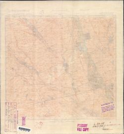
- Description:
- 1939
- Subject:
- Topical Subject: Soviet Union, Geographic Subject: Kurganinsk, and Topical Subject: Maps
- Publisher:
- Генеральный штаб Красной Армии
- Language:
- Russian
- Date Created:
- 1941
- Identifier:
- VAC9619-002430
- Genre:
- Military Maps and Topographic Maps
- Geographic Location:
- Coordinates: 44.667, 40.5, 45, 41
- Related URL:
- Catalog URL: https://iucat.iu.edu/catalog/5020129 and Download GeoTIFF: https://drive.google.com/file/d/1n2hAUvq3oxaq29_fwfN-LJ7Ne9JCyFlW/view?usp=sharing
- Abstract:
- Modern area represented: Kurganinsk, Russia
- Call Number:
- G7000 s100 .S7 sheet L-37-118
- Caption:
- Для служебного пользования
- City:
- Курганная (Kurgannaya)
- Copyright Holder:
- No Copyright - United States
- Country:
- СССР (USSR)
- State/Province:
- Адыгейская автономная область (Adyghe Autonomous oblast), Краснодарский край (Krasnodar kray), and РСФСР (RSFSR)
- Physical Description:
- Scale: 1:100,000
- Persistent URL:
- http://purl.dlib.indiana.edu/iudl/images/VAC9619/VAC9619-002430
- Provenance:
- DMA Topographic Center, OMAHA, Library of Congress Geography & Map Division
-
- Description:
- 1928
- Subject:
- Topical Subject: Maps, Topical Subject: Soviet Union, Geographic Subject: Rostov Oblast, and Geographic Subject: Chertkovskaya
- Publisher:
- Генеральный штаб Красной Армии
- Language:
- Russian
- Date Created:
- 1941
- Identifier:
- VAC9619-001998
- Genre:
- Military Maps and Topographic Maps
- Geographic Location:
- Coordinates: 47.6667, 41.5, 48, 42
- Related URL:
- Catalog URL: https://iucat.iu.edu/catalog/5020129 and Download GeoTIFF: https://drive.google.com/open?id=11t80rTxUcV87Za_wnlrRwtL99TJJVgC2
- Abstract:
- Modern area represented: Чертковская (Chertkovskaya), Rostov Oblast, Russia
- Call Number:
- G7000 s100 .S7 sheet L-37-12
- Caption:
- Для cлужебного пользования
- City:
- Чертковская (Chertkovskaya)
- Copyright Holder:
- No Copyright - United States
- Country:
- СССР (USSR)
- State/Province:
- РСФСР (RSFSR) and Ростовская область (Rostov oblast)
- Physical Description:
- Scale: 1:100,000
- Persistent URL:
- http://purl.dlib.indiana.edu/iudl/images/VAC9619/VAC9619-001998
- Provenance:
- DMA Topographic Center, Army Map Service Library, OMAHA
-
- Description:
- 1936
- Subject:
- Geographic Subject: Rozhdestvenskoye, Topical Subject: Maps, and Topical Subject: Soviet Union
- Publisher:
- Генеральный штаб Красной Армии
- Language:
- Russian
- Date Created:
- 1941
- Identifier:
- VAC9619-002432
- Genre:
- Topographic Maps and Military Maps
- Geographic Location:
- Coordinates: 44.667, 41.5, 45, 42
- Related URL:
- Download GeoTIFF: https://drive.google.com/file/d/1gay9T9TSnG0j3R8in3n6qDlLwmif_ogb/view?usp=sharing and Catalog URL: https://iucat.iu.edu/catalog/5020129
- Abstract:
- Modern area represented: Rozhdestvenskoye, Stavropol kray, Russia
- Call Number:
- G7000 s100 .S7 sheet L-37-120
- Caption:
- Для служебного пользования
- City:
- Ольгинское (Olginskoe)
- Copyright Holder:
- No Copyright - United States
- Country:
- СССР (USSR)
- State/Province:
- Краснодарский край (Krasnodar kray), РСФСР (RSFSR), and Орджоникидзевский край (Ordzhonikidze kray)
- Physical Description:
- Scale: 1:100,000
- Persistent URL:
- http://purl.dlib.indiana.edu/iudl/images/VAC9619/VAC9619-002432
- Provenance:
- DMA Topographic Center, Library of Congress G & M Division, OMAHA, Army Map Service Library
-
- Description:
- 1907
- Subject:
- Geographic Subject: Gelendzhik, Topical Subject: Soviet Union, and Topical Subject: Maps
- Publisher:
- Генеральный штаб Красной Армии
- Language:
- Russian
- Date Created:
- 1941
- Identifier:
- VAC9619-002433
- Genre:
- Topographic Maps and Military Maps
- Geographic Location:
- Coordinates: 44.333, 38, 44.667, 38.5
- Related URL:
- Catalog URL: https://iucat.iu.edu/catalog/5020129 and Download GeoTIFF: https://drive.google.com/file/d/1EEXSYKQqFySK88Xe-nbSaCzfVEmvgljz/view?usp=sharing
- Abstract:
- Modern area represented: Gelendzhik, Russia
- Call Number:
- G7000 s100 .S7 sheet L-37-125
- Caption:
- Для служебного пользования
- City:
- Геленджик (Gelendzhik)
- Copyright Holder:
- No Copyright - United States
- Country:
- СССР (USSR)
- State/Province:
- Краснодарский край (Krasnodar kray) and РСФСР (RSFSR)
- Physical Description:
- Scale: 1:100,000
- Persistent URL:
- http://purl.dlib.indiana.edu/iudl/images/VAC9619/VAC9619-002433
- Provenance:
- DMA Topographic Center, Library of Congress G & M Division, OMAHA, Army Map Service Library
-
- Description:
- 1905
- Subject:
- Geographic Subject: Goryachiy Klyuch, Topical Subject: Maps, and Topical Subject: Soviet Union
- Publisher:
- Генеральный штаб Красной Армии
- Language:
- Russian
- Date Created:
- 1941
- Identifier:
- VAC9619-002434
- Genre:
- Military Maps and Topographic Maps
- Geographic Location:
- Coordinates: 44.333, 39, 44.667, 39.5
- Related URL:
- Catalog URL: https://iucat.iu.edu/catalog/5020129 and Download GeoTIFF: https://drive.google.com/file/d/1-Ey4_jse0QsvmMlcfxbJV6ORUjUgagFu/view?usp=sharing
- Abstract:
- Modern area represented: Goryachiy Klyuch, Russia
- Call Number:
- G7000 s100 .S7 sheet L-37-127
- Caption:
- Для служебного пользования
- City:
- Горячий Ключ (Goryachiy Klyuch)
- Copyright Holder:
- No Copyright - United States
- Country:
- СССР (USSR)
- State/Province:
- Краснодарский край (Krasnodar kray) and РСФСР (RSFSR)
- Physical Description:
- Scale: 1:100,000
- Persistent URL:
- http://purl.dlib.indiana.edu/iudl/images/VAC9619/VAC9619-002434
- Provenance:
- DMA Topographic Center, Library of Congress G & M Division, OMAHA
-
- Description:
- 1905
- Subject:
- Geographic Subject: Maykop, Topical Subject: Soviet Union, and Topical Subject: Maps
- Publisher:
- Генеральный штаб Красной Армии
- Language:
- Russian
- Date Created:
- 1941
- Identifier:
- VAC9619-002436
- Genre:
- Military Maps and Topographic Maps
- Geographic Location:
- Coordinates: 44.333, 40, 44.667, 40.5
- Related URL:
- Download GeoTIFF: https://drive.google.com/file/d/1RmND2qg2kyKd_KsMXx0QKdErzc-6clez/view?usp=sharing and Catalog URL: https://iucat.iu.edu/catalog/5020129
- Abstract:
- Modern area represented: Maykop, Adygeya Republic, Russia
- Call Number:
- G7000 s100 .S7 sheet L-37-129
- Caption:
- Для служебного пользования
- City:
- Майкоп (Maykop)
- Copyright Holder:
- No Copyright - United States
- Country:
- СССР (USSR)
- State/Province:
- Краснодарский край (Krasnodar kray), Адыгейская автономная область (Adyghe Autonomous oblast), and РСФСР (RSFSR)
- Physical Description:
- Scale: 1:100,000
- Persistent URL:
- http://purl.dlib.indiana.edu/iudl/images/VAC9619/VAC9619-002436
- Provenance:
- DMA Topographic Center, Library of Congress G & M Division, OMAHA, Army Map Service Library
-
- Description:
- 1905
- Subject:
- Topical Subject: Maps, Topical Subject: Soviet Union, and Geographic Subject: Maykop
- Publisher:
- Генеральный штаб Красной Армии
- Language:
- Russian
- Date Created:
- 1941
- Identifier:
- VAC9619-002435
- Genre:
- Military Maps and Topographic Maps
- Geographic Location:
- Coordinates: 44.333, 40, 44.667, 40.5
- Related URL:
- Download GeoTIFF: https://drive.google.com/file/d/1g-16LaiQgYRAExDRCjNvhagGE8hru7Rr/view?usp=sharing and Catalog URL: https://iucat.iu.edu/catalog/5020129
- Abstract:
- Modern area represented: Maykop, Adygeya Republic, Russia
- Call Number:
- G7000 s100 .S7 sheet L-37-129
- Caption:
- Для служебного пользования
- City:
- Майкоп (Maykop)
- Copyright Holder:
- No Copyright - United States
- Country:
- СССР (USSR)
- State/Province:
- РСФСР (RSFSR) and Краснодарский край (Krasnodar kray)
- Physical Description:
- Scale: 1:100,000
- Persistent URL:
- http://purl.dlib.indiana.edu/iudl/images/VAC9619/VAC9619-002435
- Provenance:
- Army Map Service Library, Library of Congress G & M Division
-
- Description:
- 1931
- Subject:
- Topical Subject: Soviet Union, Geographic Subject: Labinsk, and Topical Subject: Maps
- Publisher:
- Генеральный штаб Красной Армии
- Language:
- Russian
- Date Created:
- 1941
- Identifier:
- VAC9619-002437
- Genre:
- Topographic Maps and Military Maps
- Geographic Location:
- Coordinates: 44.333, 40.5, 44.667, 41
- Related URL:
- Catalog URL: https://iucat.iu.edu/catalog/5020129 and Download GeoTIFF: https://drive.google.com/file/d/15ITjb5-tSTVARNE_DYffMktRmVL86iLn/view?usp=sharing
- Abstract:
- Modern area represented: Labinsk, Krasnodarsk kray, Russia
- Call Number:
- G7000 s100 .S7 sheet L-37-130
- Caption:
- Для служебного пользования
- City:
- Лабинская (Labinskaya)
- Copyright Holder:
- No Copyright - United States
- Country:
- СССР (USSR)
- State/Province:
- РСФСР (RSFSR), Адыгейская автономная область (Adyghe Autonomous oblast), and Краснодарский край (Krasnodar kray)
- Physical Description:
- Scale: 1:100,000
- Persistent URL:
- http://purl.dlib.indiana.edu/iudl/images/VAC9619/VAC9619-002437
- Provenance:
- Army Map Service Library, Library of Congress G & M Division
-
- Description:
- 1929
- Subject:
- Geographic Subject: Voznesenskaya, Topical Subject: Soviet Union, and Topical Subject: Maps
- Publisher:
- Генеральный штаб Красной Армии
- Language:
- Russian
- Date Created:
- 1941
- Identifier:
- VAC9619-002438
- Genre:
- Military Maps and Topographic Maps
- Geographic Location:
- Coordinates: 44.333, 41, 44.667, 41.5
- Related URL:
- Catalog URL: https://iucat.iu.edu/catalog/5020129 and Download GeoTIFF: https://drive.google.com/file/d/18-U76UuU0fP41OB13qku7d3huEfn8pMg/view?usp=sharing
- Abstract:
- Modern area represented: Voznesenskaya, Krasnodar kray, Russia
- Call Number:
- G7000 s100 .S7 sheet L-37-131
- Caption:
- Для служебного пользования
- City:
- Вознесенская (Voznesenskaya)
- Copyright Holder:
- No Copyright - United States
- Country:
- СССР (USSR)
- State/Province:
- Орджоникидзевский край (Ordzhonikidze kray), РСФСР (RSFSR), and Краснодарский край (Krasnodar kray)
- Physical Description:
- Scale: 1:100,000
- Persistent URL:
- http://purl.dlib.indiana.edu/iudl/images/VAC9619/VAC9619-002438
- Provenance:
- DMA Topographic Center, Library of Congress G & M Division, OMAHA, Army Map Service Library
-
- Description:
- 1928
- Subject:
- Topical Subject: Maps, Geographic Subject: Nevinnomyssk, and Topical Subject: Soviet Union
- Publisher:
- Генеральный штаб Красной Армии
- Language:
- Russian
- Date Created:
- 1941
- Identifier:
- VAC9619-002439
- Genre:
- Topographic Maps and Military Maps
- Geographic Location:
- Coordinates: 44.333, 41.5, 44.667, 42
- Related URL:
- Download GeoTIFF: https://drive.google.com/file/d/1fIJtjhFnQ3o2qiVE8VwRFXnv2XYaP3cp/view?usp=sharing and Catalog URL: https://iucat.iu.edu/catalog/5020129
- Abstract:
- Modern area represented: Nevinnomyssk, Stavropol kray, Russia
- Call Number:
- G7000 s100 .S7 sheet L-37-132
- Caption:
- Для служебного пользования
- City:
- Невинномысск (Nevinnomyssk)
- Copyright Holder:
- No Copyright - United States
- Country:
- СССР (USSR)
- State/Province:
- РСФСР (RSFSR), Краснодарский край (Krasnodar kray), and Орджоникидзевский край (Ordzhonikidze kray)
- Physical Description:
- Scale: 1:100,000
- Persistent URL:
- http://purl.dlib.indiana.edu/iudl/images/VAC9619/VAC9619-002439
- Provenance:
- DMA Topographic Center, Library of Congress G & M Division, OMAHA, Army Map Service Library
-
- Description:
- 1905
- Subject:
- Topical Subject: Soviet Union, Topical Subject: Maps, and Geographic Subject: Samurskaya
- Publisher:
- Генеральный штаб Красной Армии
- Language:
- Russian
- Date Created:
- 1942
- Identifier:
- VAC9619-002441
- Genre:
- Military Maps and Topographic Maps
- Geographic Location:
- Coordinates: 44, 39.5, 44.333, 40
- Related URL:
- Catalog URL: https://iucat.iu.edu/catalog/5020129 and Download GeoTIFF: https://drive.google.com/file/d/1b7UdBwg6eM3eqXsa4eMiC18jIGU6KjoG/view?usp=sharing
- Abstract:
- Modern area represented: Samurskaya, Russia
- Call Number:
- G7000 s100 .S7 sheet L-37-140
- Caption:
- Для служебного пользования
- City:
- Самурская (Samurskaya)
- Copyright Holder:
- No Copyright - United States
- Country:
- СССР (USSR)
- State/Province:
- Краснодарский край (Krasnodar kray) and РСФСР (RSFSR)
- Physical Description:
- Scale: 1:100,000
- Persistent URL:
- http://purl.dlib.indiana.edu/iudl/images/VAC9619/VAC9619-002441
- Provenance:
- DMA Topographic Center, Library of Congress G & M Division, OMAHA, Army Map Service Library
-
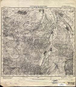
- Description:
- 1906
- Subject:
- Topical Subject: Maps, Geographic Subject: Gubskaya, and Topical Subject: Soviet Union
- Publisher:
- Генеральный штаб Красной Армии
- Language:
- Russian
- Date Created:
- 1941
- Identifier:
- VAC9619-002442
- Genre:
- Topographic Maps and Military Maps
- Geographic Location:
- Coordinates: 44, 40.5, 44.333, 41
- Related URL:
- Catalog URL: https://iucat.iu.edu/catalog/5020129 and Download GeoTIFF: https://drive.google.com/file/d/1orWbr0mjm33BPIdb-HXh7G4_m68RZfhY/view?usp=sharing
- Abstract:
- Modern area represented: Gubskaya, Krasnodar kray, Russia
- Call Number:
- G7000 s100 .S7 sheet L-37-142
- Caption:
- Для служебного пользования
- City:
- Губская (Gubskaya)
- Copyright Holder:
- No Copyright - United States
- Country:
- СССР (USSR)
- State/Province:
- Краснодарский край (Krasnodar kray), Карачаевская автономная область (Karachay Autonomous Oblast), and РСФСР (RSFSR)
- Physical Description:
- Scale: 1:100,000
- Persistent URL:
- http://purl.dlib.indiana.edu/iudl/images/VAC9619/VAC9619-002442
- Provenance:
- Library of Congress G & M Division
-
- Description:
- 1937
- Subject:
- Topical Subject: Maps, Geographic Subject: Spokoynaya, and Topical Subject: Soviet Union
- Publisher:
- Генеральный штаб Красной Армии
- Language:
- Russian
- Date Created:
- 1941
- Identifier:
- VAC9619-002443
- Genre:
- Military Maps and Topographic Maps
- Geographic Location:
- Coordinates: 44, 41, 44.333, 41.5
- Related URL:
- Catalog URL: https://iucat.iu.edu/catalog/5020129 and Download GeoTIFF: https://drive.google.com/file/d/1SgsfU20jm58R_Jh0kOy_DGAlUlJSbvAd/view?usp=sharing
- Abstract:
- Modern area represented: Spokoynaya, Krasnodar kray, Russia
- Call Number:
- G7000 s100 .S7 sheet L-37-143
- Caption:
- Для служебного пользования
- City:
- Спокойная (Spokoynaya)
- Copyright Holder:
- No Copyright - United States
- Country:
- СССР (USSR)
- State/Province:
- РСФСР (RSFSR), Черкесская автономная область (Cherkess Autonomous Oblast), and Краснодарский край (Krasnodar kray)
- Physical Description:
- Scale: 1:100,000
- Persistent URL:
- http://purl.dlib.indiana.edu/iudl/images/VAC9619/VAC9619-002443
- Provenance:
- DMA Topographic Center, Library of Congress G & M Division, OMAHA, Army Map Service Library
-
- Description:
- 1928
- Subject:
- Topical Subject: Soviet Union, Topical Subject: Maps, and Geographic Subject: Udobnaya
- Publisher:
- Генеральный штаб Красной Армии
- Language:
- Russian
- Date Created:
- 1941
- Identifier:
- VAC9619-002444
- Genre:
- Military Maps and Topographic Maps
- Geographic Location:
- Coordinates: 44, 41.5, 44.333, 42
- Related URL:
- Download GeoTIFF: https://drive.google.com/file/d/10Rvfv4VnjnKWwDmp-_bMcJE75LQHk7TY/view?usp=sharing and Catalog URL: https://iucat.iu.edu/catalog/5020129
- Abstract:
- Modern area represented: Udobnaya, Krasnodar kray, Russia
- Call Number:
- G7000 s100 .S7 sheet L-37-144
- Caption:
- Для служебного пользования
- City:
- Удобная (Udobnaya)
- Copyright Holder:
- No Copyright - United States
- Country:
- СССР (USSR)
- State/Province:
- Черкесская автономная область (Cherkess Autonomous Oblast), РСФСР (RSFSR), Карачаевская автономная область (Karachay Autonomous Oblast), and Краснодарский кр...
- Physical Description:
- Scale: 1:100,000
- Persistent URL:
- http://purl.dlib.indiana.edu/iudl/images/VAC9619/VAC9619-002444
- Provenance:
- Army Map Service Library, Library of Congress G & M Division
-
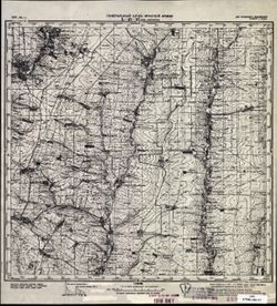
- Description:
- 1939
- Subject:
- Topical Subject: Soviet Union, Topical Subject: Maps, and Geographic Subject: Rozdolne
- Publisher:
- Генеральный штаб Красной Армии
- Language:
- Russian
- Date Created:
- 1941
- Identifier:
- VAC9619-002003
- Genre:
- Military Maps and Topographic Maps
- Geographic Location:
- Coordinates: 47.3333, 38, 47.6667, 38.5
- Related URL:
- Catalog URL: https://iucat.iu.edu/catalog/5020129 and Download GeoTIFF: https://drive.google.com/open?id=1cdFtj_43ppiv47dkF7XJ1JNspIgopc33
- Abstract:
- Modern area represented: Rozdolne, Donetsk oblast, Ukraine
- Call Number:
- G7000 s100 .S7 sheet L-37-17
- Caption:
- Для служебного пользования
- City:
- Большая Каракуба (Bolshaya Karakuba)
- Copyright Holder:
- No Copyright - United States
- Country:
- СССР (USSR)
- State/Province:
- РСФСР (RSFSR) and Украинская ССР (Ukrainian Soviet Socialist Republic)
- Physical Description:
- Scale: 1:100,000
- Persistent URL:
- http://purl.dlib.indiana.edu/iudl/images/VAC9619/VAC9619-002003
- Provenance:
- CIA Map Library
-
- Description:
- 1931
- Subject:
- Topical Subject: Maps, Geographic Subject: Donetsk, Geographic Subject: Kalmiuske, and Topical Subject: Soviet Union
- Publisher:
- Генеральный штаб Красной Армии
- Language:
- Russian
- Date Created:
- 1942
- Identifier:
- VAC9619-002004
- Genre:
- Topographic Maps and Military Maps
- Geographic Location:
- Coordinates: 47.3333, 39, 47.6667, 39.5
- Related URL:
- Download GeoTIFF: https://drive.google.com/open?id=1NZxwosLYVa9EAJO1rvzTEoZMt-K31pfv and Catalog URL: https://iucat.iu.edu/catalog/5020129
- Abstract:
- Modern area represented: Кальміуське (Kalmiuske), Donetsk, Ukraine
- Call Number:
- G7000 s100 .S7 sheet L-37-17
- Caption:
- Для cлужебного пользования
- City:
- Каракубстрой (Karakubstroy)
- Copyright Holder:
- No Copyright - United States
- Country:
- СССР (USSR)
- State/Province:
- Украинская ССР (Ukrainian Soviet Socialist Republic), Сталинская область (Stalino oblast), Ростовская область (Rostov oblast), and РСФСР (RSFSR)
- Physical Description:
- Scale: 1:100,000
- Persistent URL:
- http://purl.dlib.indiana.edu/iudl/images/VAC9619/VAC9619-002004
- Provenance:
- DMA Topographic Center, Army Map Service Library, OMAHA
-
- Description:
- 1931
- Subject:
- Topical Subject: Maps, Geographic Subject: Rostov Oblast, Geographic Subject: Bol'shekrepinskaya, and Topical Subject: Soviet Union
- Publisher:
- Генеральный штаб Красной Армии
- Language:
- Russian
- Date Created:
- 1941
- Identifier:
- VAC9619-002005
- Genre:
- Military Maps and Topographic Maps
- Geographic Location:
- Coordinates: 47.3333, 39, 47.6667, 39.5
- Related URL:
- Download GeoTIFF: https://drive.google.com/file/d/17HbaIGZOELtNFsCQB0-TRkiBY_k3iv3p/view?usp=sharing and Catalog URL: https://iucat.iu.edu/catalog/5020129
- Abstract:
- Modern area represented: Большекрепинская (Bol'shekrepinskaya), Rostov Oblast, Russia
- Call Number:
- G7000 s100 .S7 sheet L-37-19
- Caption:
- Для cлужебного пользования
- City:
- Большекрепинская (Bol'shekrepinskaya)
- Copyright Holder:
- No Copyright - United States
- Country:
- СССР (USSR)
- State/Province:
- Ростовская область (Rostov oblast) and РСФСР (RSFSR)
- Physical Description:
- Scale: 1:100,000
- Persistent URL:
- http://purl.dlib.indiana.edu/iudl/images/VAC9619/VAC9619-002005
- Provenance:
- DMA Topographic Center, Army Map Service Library, OMAHA
-
- Description:
- 1926
- Subject:
- Topical Subject: Maps, Geographic Subject: Grushevskaya, and Topical Subject: Soviet Union
- Publisher:
- Генеральный штаб Красной Армии
- Language:
- Russian
- Date Created:
- 1941
- Identifier:
- VAC9619-002006
- Genre:
- Topographic Maps and Military Maps
- Geographic Location:
- Coordinates: 47.3333, 39.5, 47.6667, 40
- Related URL:
- Catalog URL: https://iucat.iu.edu/catalog/5020129 and Download GeoTIFF: https://drive.google.com/open?id=142dOU_I0P9WXPhKJgiCrx-ldSjSb1GRW
- Abstract:
- Modern area represented: Grushevskaya, Rostov oblast, Russia
- Call Number:
- G7000 s100 .S7 sheet L-37-20
- Caption:
- Для служебного пользования
- City:
- Грушевская (Grushevskaya)
- Copyright Holder:
- No Copyright - United States
- Country:
- СССР (USSR)
- State/Province:
- Ростовская область (Rostov oblast) and РСФСР (RSFSR)
- Physical Description:
- Scale: 1:100,000
- Persistent URL:
- http://purl.dlib.indiana.edu/iudl/images/VAC9619/VAC9619-002006
- Provenance:
- DMA Topographic Center, Army Map Service Library
-
- Description:
- 1926
- Subject:
- Geographic Subject: Rostov Oblast, Geographic Subject: Novocherkassk, Topical Subject: Soviet Union, and Topical Subject: Maps
- Publisher:
- Генеральный штаб Красной Армии
- Language:
- Russian
- Date Created:
- 1941
- Identifier:
- VAC9619-002007
- Genre:
- Topographic Maps and Military Maps
- Geographic Location:
- Coordinates: 47.3333, 40, 47.6667, 40.5
- Related URL:
- Catalog URL: https://iucat.iu.edu/catalog/5020129 and Download GeoTIFF: https://drive.google.com/open?id=1GVtjPJc8oKnlyMb15hT_1UZryDtiYZXw
- Abstract:
- Modern area represented: Новочеркасск (Novocherkassk), Rostov Oblast, Russia
- Call Number:
- G7000 s100 .S7 sheet L-37-21
- Caption:
- Для cлужебного пользования
- City:
- Новочеркасск (Novocherkassk)
- Copyright Holder:
- No Copyright - United States
- Country:
- СССР (USSR)
- State/Province:
- РСФСР (RSFSR) and Ростовская область (Rostov oblast)
- Physical Description:
- Scale: 1:100,000
- Persistent URL:
- http://purl.dlib.indiana.edu/iudl/images/VAC9619/VAC9619-002007
- Provenance:
- DMA Topographic Center, Army Map Service Library, OMAHA
-
- Description:
- 1922
- Subject:
- Topical Subject: Soviet Union, Geographic Subject: Semikarakorsk, and Topical Subject: Maps
- Publisher:
- Генеральный штаб Красной Армии
- Language:
- Russian
- Date Created:
- 1941
- Identifier:
- VAC9619-002280
- Genre:
- Topographic Maps and Military Maps
- Geographic Location:
- Coordinates: 47.3333, 40.5, 47.6667, 41
- Related URL:
- Catalog URL: https://iucat.iu.edu/catalog/5020129 and Download GeoTIFF: https://drive.google.com/file/d/11yBcLo4t8uAgLkBijjPTDKC_3DMJbHBV/view?usp=sharing
- Abstract:
- Modern area represented: Semikarakorsk, Russia
- Call Number:
- G7000 s100 .S7 sheet L-37-22
- City:
- Семикаракорская (Semikarakorskaya)
- Copyright Holder:
- No Copyright - United States
- Country:
- СССР (USSR)
- State/Province:
- Ростовская область (Rostov oblast) and РСФСР (RSFSR)
- Physical Description:
- Scale: 1:100,000
- Persistent URL:
- http://purl.dlib.indiana.edu/iudl/images/VAC9619/VAC9619-002280
- Provenance:
- DMA Topographic Center, Army Map Service Library, OMAHA
-
- Description:
- 1927
- Subject:
- Topical Subject: Soviet Union, Topical Subject: Maps, and Geographic Subject: Konstantinovsk
- Publisher:
- Генеральный штаб Красной Армии
- Language:
- Russian
- Date Created:
- 1941
- Identifier:
- VAC9619-002281
- Genre:
- Military Maps and Topographic Maps
- Geographic Location:
- Coordinates: 47.3333, 41, 47.6667, 41.5
- Related URL:
- Catalog URL: https://iucat.iu.edu/catalog/5020129 and Download GeoTIFF: https://drive.google.com/file/d/1aq7wrbLoi1meDlmoYD_2ih5ENMkkVxBU/view?usp=sharing
- Abstract:
- Modern area represented: Konstantinovsk, Russia
- Call Number:
- G7000 s100 .S7 sheet L-37-23
- Caption:
- Для cлужебного пользования
- City:
- Константиновская (Konstantinovskaya)
- Copyright Holder:
- No Copyright - United States
- Country:
- СССР (USSR)
- State/Province:
- РСФСР (RSFSR) and Ростовская область (Rostov oblast)
- Physical Description:
- Scale: 1:100,000
- Persistent URL:
- http://purl.dlib.indiana.edu/iudl/images/VAC9619/VAC9619-002281
- Provenance:
- DMA Topographic Center, Army Map Service Library, OMAHA
-
- Subject:
- Topical Subject: Soviet Union, Geographic Subject: Byeglitskaya Spit, and Topical Subject: Maps
- Publisher:
- Генеральный штаб Красной Армии
- Language:
- Russian
- Identifier:
- VAC9619-000126
- Genre:
- Topographic Maps and Military Maps
- Geographic Location:
- Coordinates: 47, 38.5, 47.1667, 38.75
- Related URL:
- Catalog URL: http://iucat.iu.edu/catalog/5020131 and Download GeoTIFF: https://drive.google.com/open?id=1v122mO_SmKQSM5zBex63FJBogjJZ8VRs
- Abstract:
- Modern area represented: Byeglitskaya Spit, Rostov oblast, Russia
- Call Number:
- G7000 s50 .S68 sheet L-37-30-B
- Caption:
- Для служебного пользования
- City:
- Хутора Беглицкая Коса (Khutora Byeglitskaya Kosa)
- Copyright Holder:
- No Copyright - United States
- Country:
- СССР (USSR)
- State/Province:
- РСФСР (RSFSR) and Ростовская область (Rostov oblast)
- Physical Description:
- Scale: 1:50,000
- Persistent URL:
- http://purl.dlib.indiana.edu/iudl/images/VAC9619/VAC9619-000126
- Provenance:
- DMA Topographic Center, Army Map Service Library, Library of Congress Geography & Map Division
-
- Description:
- 1926
- Subject:
- Geographic Subject: Azov, Geographic Subject: Rostov oblast, Topical Subject: Soviet Union, and Topical Subject: Maps
- Publisher:
- Главное управление геодезии и картографии при СНК СССР
- Language:
- Russian
- Date Created:
- 1940
- Identifier:
- VAC9619-002285
- Genre:
- Topographic Maps and Military Maps
- Geographic Location:
- Coordinates: 47, 39, 47.3333, 39.5
- Related URL:
- Download GeoTIFF: https://drive.google.com/file/d/1ZVtvAnypf4ZFXI2NppFs0SerXf00lb1Z/view?usp=sharing and Catalog URL: https://iucat.iu.edu/catalog/5020129
- Abstract:
- Modern area represented: Azov, Russia
- Call Number:
- G7000 s100 .S7 sheet L-37-31
- Caption:
- Для служебного пользования
- City:
- Азов (Azov)
- Copyright Holder:
- No Copyright - United States
- Country:
- СССР (USSR)
- State/Province:
- Ростовская область (Rostov oblast) and РСФСР (RSFSR)
- Physical Description:
- Scale: 1:100,000
- Persistent URL:
- http://purl.dlib.indiana.edu/iudl/images/VAC9619/VAC9619-002285
- Provenance:
- Geographic Names Branch, Heeresplankammer 1. Abt. (Pl. A.) Auslandskartenarchiv
-
- Description:
- 1926
- Subject:
- Topical Subject: Soviet Union, Topical Subject: Maps, and Geographic Subject: Rostov
- Publisher:
- Главное управление геодезии и картографии при СНК СССР
- Language:
- Russian
- Date Created:
- 1941
- Identifier:
- VAC9619-002286
- Genre:
- Topographic Maps and Military Maps
- Geographic Location:
- Coordinates: 47, 39.5, 47.3333, 40
- Related URL:
- Catalog URL: https://iucat.iu.edu/catalog/5020129 and Download GeoTIFF: https://drive.google.com/file/d/1XcqLQR-DzZL4b2V2aY4UGhly62ywbl77/view?usp=sharing
- Abstract:
- Modern area represented: Rostov, Russia
- Call Number:
- G7000 s100 .S7 sheet L-37-32
- Caption:
- Для служебного пользования
- City:
- Ростов (Rostov)
- Copyright Holder:
- No Copyright - United States
- Country:
- СССР (USSR)
- State/Province:
- Ростовская область (Rostov oblast) and РСФСР (RSFSR)
- Physical Description:
- Scale: 1:100,000
- Persistent URL:
- http://purl.dlib.indiana.edu/iudl/images/VAC9619/VAC9619-002286
- Provenance:
- DMA Topographic Center, Army Map Service Library
-
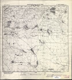
- Description:
- 1926
- Subject:
- Topical Subject: Soviet Union, Geographic Subject: Bagayevskaya, and Topical Subject: Maps
- Publisher:
- Генеральный штаб Красной Армии
- Language:
- Russian
- Date Created:
- 1941
- Identifier:
- VAC9619-002287
- Genre:
- Military Maps and Topographic Maps
- Geographic Location:
- Coordinates: 47, 40, 47.3333, 40.5
- Related URL:
- Download GeoTIFF: https://drive.google.com/file/d/1c-tw5VxGi2_8mSBvS9z5V2Q-EtcSlk6D/view?usp=sharing and Catalog URL: https://iucat.iu.edu/catalog/5020129
- Abstract:
- Modern area represented: Bagayevskaya, Russia
- Call Number:
- G7000 s100 .S7 sheet L-37-33
- Caption:
- Для служебного пользования
- City:
- Багаевская (Bagayevskaya)
- Copyright Holder:
- No Copyright - United States
- Country:
- СССР (USSR)
- State/Province:
- Ростовская область (Rostov oblast) and РСФСР (RSFSR)
- Physical Description:
- Scale: 1:100,000
- Persistent URL:
- http://purl.dlib.indiana.edu/iudl/images/VAC9619/VAC9619-002287
- Provenance:
- CIA Map Library
-
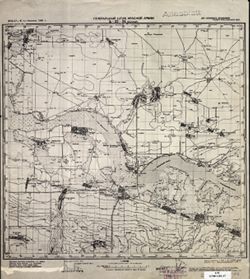
- Description:
- 1932
- Subject:
- Topical Subject: Soviet Union, Topical Subject: Maps, and Geographic Subject: Veselyy
- Publisher:
- Генеральный штаб Красной Армии
- Language:
- Russian
- Date Created:
- 1941
- Identifier:
- VAC9619-002288
- Genre:
- Topographic Maps and Military Maps
- Geographic Location:
- Coordinates: 47, 40.5, 47.3333, 41
- Related URL:
- Download GeoTIFF: https://drive.google.com/file/d/1x_6moHatJsnMhQhHzqjSPuO0h_az_FsS/view?usp=sharing and Catalog URL: https://iucat.iu.edu/catalog/5020129
- Abstract:
- Modern area represented: Veselyy, Russia
- Call Number:
- G7000 s100 .S7 sheet L-37-34
- Caption:
- Для служебного пользования
- City:
- Веселый (Veselyy)
- Copyright Holder:
- No Copyright - United States
- Country:
- СССР (USSR)
- State/Province:
- Ростовская область (Rostov oblast) and РСФСР (RSFSR)
- Physical Description:
- Scale: 1:100,000
- Persistent URL:
- http://purl.dlib.indiana.edu/iudl/images/VAC9619/VAC9619-002288
- Provenance:
- CIA Map Library
-
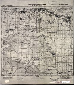
- Description:
- 1928
- Subject:
- Topical Subject: Soviet Union, Topical Subject: Maps, and Geographic Subject: Bolshaya Orlovka
- Publisher:
- Генеральный штаб Красной Армии
- Language:
- Russian
- Date Created:
- 1941
- Identifier:
- VAC9619-002289
- Genre:
- Topographic Maps and Military Maps
- Geographic Location:
- Coordinates: 47, 41, 47.3333, 41.5
- Related URL:
- Catalog URL: https://iucat.iu.edu/catalog/5020129 and Download GeoTIFF: https://drive.google.com/file/d/1lR13kKQkWmyWUUarjbFsVQ_lp0yc8aya/view?usp=sharing
- Abstract:
- Modern area represented: Bolshaya Orlovka, Russia
- Call Number:
- G7000 s100 .S7 sheet L-37-35
- Caption:
- Для служебного пользования
- City:
- Большая Орловка (Bolshaya Orlovka)
- Copyright Holder:
- No Copyright - United States
- Country:
- СССР (USSR)
- State/Province:
- Ростовская область (Rostov oblast) and РСФСР (RSFSR)
- Physical Description:
- Scale: 1:100,000
- Persistent URL:
- http://purl.dlib.indiana.edu/iudl/images/VAC9619/VAC9619-002289
- Provenance:
- CIA Map Library
-
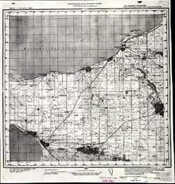
- Description:
- 1935
- Subject:
- Topical Subject: Maps, Geographic Subject: Yeyskoye Ukrepleniye, and Topical Subject: Soviet Union
- Publisher:
- Генеральный штаб Красной Армии
- Language:
- Russian
- Date Created:
- 1938
- Identifier:
- VAC9619-002293
- Genre:
- Topographic Maps and Military Maps
- Geographic Location:
- Coordinates: 46.6667, 38.5, 47, 39
- Related URL:
- Catalog URL: https://iucat.iu.edu/catalog/5020129 and Download GeoTIFF: https://drive.google.com/file/d/1l8Y0gwYEf2tBKWG4raDsZHtB57IQK3rB/view?usp=sharing
- Abstract:
- Modern area represented: Yeyskoye Ukrepleniye, Krasnodar kray, Russia
- Call Number:
- G7000 s100 .S7 sheet L-37-42
- Caption:
- Для служебного пользования
- City:
- Ейское Укрепление (Yeyskoye Ukrepleniye)
- Copyright Holder:
- No Copyright - United States
- Country:
- СССР (USSR)
- State/Province:
- Краснодарский край (Krasnodar kray), РСФСР (RSFSR), and Ростовская область (Rostov oblast)
- Physical Description:
- Scale: 1:100,000
- Persistent URL:
- http://purl.dlib.indiana.edu/iudl/images/VAC9619/VAC9619-002293
- Provenance:
- CIA Map Library
-
- Description:
- 1935
- Subject:
- Geographic Subject: Aleksandrovka, Topical Subject: Maps, and Topical Subject: Soviet Union
- Publisher:
- Главное управление геодезии и картографии при СНК СССР
- Language:
- Russian
- Date Created:
- 1940
- Identifier:
- VAC9619-002294
- Genre:
- Military Maps and Topographic Maps
- Geographic Location:
- Coordinates: 46.6667, 39, 47, 39.5
- Related URL:
- Catalog URL: https://iucat.iu.edu/catalog/5020129 and Download GeoTIFF: https://drive.google.com/file/d/12RMoPzLmycgdNa_ZeRr0BYWXrRKFao9C/view?usp=sharing
- Abstract:
- Modern area represented: Aleksandrovka, Krasnodar kray, Russia
- Call Number:
- G7000 s100 .S7 sheet L-37-43
- Caption:
- Для служебного пользования
- City:
- Александровка (Aleksandrovka)
- Copyright Holder:
- No Copyright - United States
- Country:
- СССР (USSR)
- State/Province:
- Краснодарский край (Krasnodar kray), Ростовская область (Rostov oblast), and РСФСР (RSFSR)
- Physical Description:
- Scale: 1:100,000
- Persistent URL:
- http://purl.dlib.indiana.edu/iudl/images/VAC9619/VAC9619-002294
- Provenance:
- DMA Topographic Center, Army Map Service Library, OMAHA, Library of Congress Geography & Map Division
-
- Description:
- 1927
- Subject:
- Topical Subject: Maps, Geographic Subject: Samarskoe, and Topical Subject: Soviet Union
- Publisher:
- Генеральный штаб Красной Армии
- Language:
- Russian
- Date Created:
- 1941
- Identifier:
- VAC9619-002295
- Genre:
- Topographic Maps and Military Maps
- Geographic Location:
- Coordinates: 46.6667, 39.5, 47, 40
- Related URL:
- Download GeoTIFF: https://drive.google.com/file/d/1_26etJDL3qxqsjyI95YqndQ-0poVd8mx/view?usp=sharing and Catalog URL: https://iucat.iu.edu/catalog/5020129
- Abstract:
- Modern area represented: Samarskoe, Rostov oblast, Russia
- Call Number:
- G7000 s100 .S7 sheet L-37-44
- Caption:
- Для служебного пользования
- City:
- Самарское (Samarskoe)
- Copyright Holder:
- No Copyright - United States
- Country:
- СССР (USSR)
- State/Province:
- Ростовская область (Rostov oblast), Краснодарский край (Krasnodar kray), and РСФСР (RSFSR)
- Physical Description:
- Scale: 1:100,000
- Persistent URL:
- http://purl.dlib.indiana.edu/iudl/images/VAC9619/VAC9619-002295
- Provenance:
- DMA Topographic Center, Army Map Service Library, OMAHA, Library of Congress Geography & Map Division
-
- Description:
- 1940
- Subject:
- Topical Subject: Maps, Geographic Subject: Kagalnitskaya, and Topical Subject: Soviet Union
- Publisher:
- Генеральный штаб Красной Армии
- Language:
- Russian
- Date Created:
- 1941
- Identifier:
- VAC9619-002296
- Genre:
- Topographic Maps and Military Maps
- Geographic Location:
- Coordinates: 46.6667, 40, 47, 40.5
- Related URL:
- Download GeoTIFF: https://drive.google.com/file/d/1Th9UTQoqlc3eaSAwJhh02Zn8qH9JmSCu/view?usp=sharing and Catalog URL: https://iucat.iu.edu/catalog/5020129
- Abstract:
- Modern area represented: Kagalnitskaya, Rostov oblast, Russia
- Call Number:
- G7000 s100 .S7 sheet L-37-45
- Caption:
- Для служебного пользования
- City:
- Кагальницкая (Kagalnitskaya)
- Copyright Holder:
- No Copyright - United States
- Country:
- СССР (USSR)
- State/Province:
- РСФСР (RSFSR), Краснодарский край (Krasnodar kray), and Ростовская область (Rostov oblast)
- Physical Description:
- Scale: 1:100,000
- Persistent URL:
- http://purl.dlib.indiana.edu/iudl/images/VAC9619/VAC9619-002296
- Provenance:
- DMA Topographic Center, OMAHA, Library of Congress Geography & Map Division
-
- Description:
- 1926
- Subject:
- Topical Subject: Soviet Union, Topical Subject: Maps, and Geographic Subject: Novokuznetsovka
- Publisher:
- Генеральный штаб Красной Армии
- Language:
- Russian
- Date Created:
- 1941
- Identifier:
- VAC9619-002298
- Genre:
- Military Maps and Topographic Maps
- Geographic Location:
- Coordinates: 46.6667, 40.5, 47, 41
- Related URL:
- Catalog URL: https://iucat.iu.edu/catalog/5020129 and Download GeoTIFF: https://drive.google.com/file/d/1sfqT_AJuBAAUv8hm-9cOJcZvvbSOsD7N/view?usp=sharing
- Abstract:
- Modern area represented: Novokuznetsovka, Russia
- Call Number:
- G7000 s100 .S7 sheet L-37-46
- Caption:
- Для служебного пользования
- City:
- Ново-Кузнецовка (Novo-Kuznetsovka)
- Copyright Holder:
- No Copyright - United States
- Country:
- СССР (USSR)
- State/Province:
- Ростовская область (Rostov oblast) and РСФСР (RSFSR)
- Physical Description:
- Scale: 1:100,000
- Persistent URL:
- http://purl.dlib.indiana.edu/iudl/images/VAC9619/VAC9619-002298
- Provenance:
- DMA Topographic Center, Army Map Service Library, Library of Congress Geography & Map Division
-
- Description:
- 1926
- Subject:
- Geographic Subject: Novokuznetsovka, Topical Subject: Soviet Union, and Topical Subject: Maps
- Publisher:
- Генеральный штаб Красной Армии
- Language:
- Russian
- Date Created:
- 1941
- Identifier:
- VAC9619-002297
- Genre:
- Military Maps and Topographic Maps
- Geographic Location:
- Coordinates: 46.6667, 40.5, 47, 41
- Related URL:
- Catalog URL: https://iucat.iu.edu/catalog/5020129 and Download GeoTIFF: https://drive.google.com/file/d/1oP0FVYH1z5c_1xKG5gOyc8WesSVRRnmC/view?usp=sharing
- Abstract:
- Modern area represented: Novokuznetsovka, Russia
- Call Number:
- G7000 s100 .S7 sheet L-37-46
- Caption:
- Для служебного пользования
- City:
- Ново-Кузнецовка (Novo-Kuznetsovka)
- Copyright Holder:
- No Copyright - United States
- Country:
- СССР (USSR)
- State/Province:
- Ростовская область (Rostov oblast) and РСФСР (RSFSR)
- Physical Description:
- Scale: 1:100,000
- Persistent URL:
- http://purl.dlib.indiana.edu/iudl/images/VAC9619/VAC9619-002297
- Provenance:
- Army Map Service Library, Library of Congress G & M Division
-
- Description:
- 1926
- Subject:
- Geographic Subject: Zhuravlyovka, Topical Subject: Soviet Union, and Topical Subject: Maps
- Publisher:
- Генеральный штаб Красной Армии
- Language:
- Russian
- Date Created:
- 1941
- Identifier:
- VAC9619-002299
- Genre:
- Military Maps and Topographic Maps
- Geographic Location:
- Coordinates: 46.6667, 41, 47, 41.5
- Related URL:
- Catalog URL: https://iucat.iu.edu/catalog/5020129 and Download GeoTIFF: https://drive.google.com/file/d/1RZe7TX8nGnwp5iv7M1fYWr1GLhQJkoo7/view?usp=sharing
- Abstract:
- Modern area represented: Zhuravlyovka, Russia
- Call Number:
- G7000 s100 .S7 sheet L-37-47
- Caption:
- Для служебного пользования
- City:
- Журавлевка (Zhuravlyovka)
- Copyright Holder:
- No Copyright - United States
- Country:
- СССР (USSR)
- State/Province:
- Ростовская область (Rostov oblast) and РСФСР (RSFSR)
- Physical Description:
- Scale: 1:100,000
- Persistent URL:
- http://purl.dlib.indiana.edu/iudl/images/VAC9619/VAC9619-002299
- Provenance:
- DMA Topographic Center, Army Map Service Library
-
- Description:
- 1927
- Subject:
- Topical Subject: Soviet Union, Geographic Subject: Proletarsk, and Topical Subject: Maps
- Publisher:
- Генеральный штаб Красной Армии
- Language:
- Russian
- Date Created:
- 1941
- Identifier:
- VAC9619-002318
- Genre:
- Topographic Maps and Military Maps
- Geographic Location:
- Coordinates: 46.6667, 41.5, 47, 42
- Related URL:
- Download GeoTIFF: https://drive.google.com/file/d/1EQdvTAY6UUX6IM4qqYOuPQRMapFoG7oG/view?usp=sharing and Catalog URL: https://iucat.iu.edu/catalog/5020129
- Abstract:
- Modern area represented: Proletarsk, Russia
- Call Number:
- G7000 s100 .S7 sheet L-37-48
- Caption:
- Для служебного пользования
- City:
- Пролетарская (Proletarskaya)
- Copyright Holder:
- No Copyright - United States
- Country:
- СССР (USSR)
- State/Province:
- Ростовская область (Rostov oblast) and РСФСР (RSFSR)
- Physical Description:
- Scale: 1:100,000
- Persistent URL:
- http://purl.dlib.indiana.edu/iudl/images/VAC9619/VAC9619-002318
- Provenance:
- CIA Map Library, Army Map Service Library, Library of Congress Geography & Map Division
-
- Description:
- 1935
- Subject:
- Topical Subject: Maps, Topical Subject: Soviet Union, and Geographic Subject: Kamyshevatskaya
- Publisher:
- Главное управление геодезии и картографии при СНК СССР
- Language:
- Russian
- Date Created:
- 1940
- Identifier:
- VAC9619-002469
- Genre:
- Topographic Maps and Military Maps
- Geographic Location:
- Coordinates: 46.333, 37.5, 46.667, 38
- Related URL:
- Catalog URL: https://iucat.iu.edu/catalog/5020129 and Download GeoTIFF: https://drive.google.com/file/d/1FZNP0AszmtgO2r8VCGGm5F4L25pPyivc/view?usp=sharing
- Abstract:
- Modern area represented: Kamyshevatskaya, Russia
- Call Number:
- G7000 s100 .S7 sheet L-37-52
- Caption:
- Для служебного пользования
- City:
- Станница Камышеватская (Kamyshevatskaya)
- Copyright Holder:
- No Copyright - United States
- Country:
- СССР (USSR)
- State/Province:
- Краснодарский край (Krasnodar kray) and РСФСР (RSFSR)
- Physical Description:
- Scale: 1:100,000
- Persistent URL:
- http://purl.dlib.indiana.edu/iudl/images/VAC9619/VAC9619-002469
- Provenance:
- DMA Topographic Center, Library of Congress G & M Division, OMAHA, Army Map Service Library
-
- Description:
- 1935
- Subject:
- Topical Subject: Soviet Union, Geographic Subject: Yasenskaya, and Topical Subject: Maps
- Publisher:
- Генеральный штаб Красной Армии
- Language:
- Russian
- Date Created:
- 1940
- Identifier:
- VAC9619-002320
- Genre:
- Military Maps and Topographic Maps
- Geographic Location:
- Coordinates: 46.3333, 38, 46.6667, 38.5
- Related URL:
- Catalog URL: https://iucat.iu.edu/catalog/5020129 and Download GeoTIFF: https://drive.google.com/file/d/1ANfBQuPlscLZ3TLWYKArV4_UX4oV-Ab6/view?usp=sharing
- Abstract:
- Modern area represented: Yasenskaya, Russia
- Call Number:
- G7000 s100 .S7 sheet L-37-53
- Caption:
- Для служебного пользования
- City:
- Ст-ца Ясенская (Yasenskaya)
- Copyright Holder:
- No Copyright - United States
- Country:
- СССР (USSR)
- State/Province:
- РСФСР (RSFSR) and Краснодарский край (Krasnodar kray)
- Physical Description:
- Scale: 1:100,000
- Persistent URL:
- http://purl.dlib.indiana.edu/iudl/images/VAC9619/VAC9619-002320
- Provenance:
- DMA Topographic Center, Army Map Service Library
