
Search Constraints
You searched for:
Provenance
DMA Topographic Center, Army Map Service Library
Remove constraint Provenance: DMA Topographic Center, Army Map Service Library
« Previous |
1 - 10 of 221
|
Next »
Search Results
-
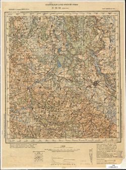
- Description:
- 1903
- Subject:
- Geographic Subject: Smarhon, Topical Subject: Maps, and Topical Subject: Soviet Union
- Publisher:
- Генеральный штаб Красной Армии
- Language:
- Russian
- Date Created:
- 1940
- Identifier:
- VAC9619-004055
- Genre:
- Topographic Maps and Military Maps
- Geographic Location:
- Coordinates: 54.333, 26, 54.667, 26.5
- Related URL:
- Download GeoTIFF: https://drive.google.com/file/d/1Hyh1FTHPh2WfcSA6rFTZ67hecvz2-9cA/view?usp=sharing and Catalog URL: https://iucat.iu.edu/catalog/5020129
- Abstract:
- Modern area represented: Smarhon, Hrodna oblast, Belarus
- Call Number:
- G7000 s100 .S7 sheet N-35-53
- City:
- Сморгонь (Smarhon)
- Copyright Holder:
- No Copyright - United States
- Country:
- СССР (USSR)
- State/Province:
- Белорусская ССР (Byelorussian Soviet Socialist Republic) and Вилейская область (Vileyka oblast)
- Physical Description:
- Scale: 1:100,000
- Persistent URL:
- http://purl.dlib.indiana.edu/iudl/images/VAC9619/VAC9619-004055
- Provenance:
- DMA Topographic Center, Army Map Service Library
-
- Description:
- 1901
- Subject:
- Topical Subject: Maps, Geographic Subject: Utena, and Topical Subject: Soviet Union
- Publisher:
- Генеральный штаб РККА
- Language:
- Russian
- Date Created:
- 1903
- Identifier:
- VAC9619-004018
- Genre:
- Topographic Maps and Military Maps
- Geographic Location:
- Coordinates: 55.333, 25.5, 55.667, 26
- Related URL:
- Download GeoTIFF: https://drive.google.com/file/d/1pEEG0_-uG8tVJDX5J7ToJBZF8UXZ4fwm/view?usp=sharing and Catalog URL: https://iucat.iu.edu/catalog/5020129
- Abstract:
- Modern area represented: Utena, Lithuania
- Call Number:
- G7000 s100 .S7 sheet N-35-16
- City:
- Утена (Utena)
- Copyright Holder:
- No Copyright - United States
- Country:
- Литва (Lithuania) and Польша (Poland)
- Physical Description:
- Scale: 1:100,000
- Persistent URL:
- http://purl.dlib.indiana.edu/iudl/images/VAC9619/VAC9619-004018
- Provenance:
- DMA Topographic Center, Army Map Service Library
-
- Description:
- 1927
- Subject:
- Topical Subject: Maps, Geographic Subject: Tyntsy, and Topical Subject: Soviet Union
- Publisher:
- Управление военных топографов РККА
- Language:
- Russian
- Identifier:
- VAC9619-002272
- Genre:
- Military Maps and Topographic Maps
- Geographic Location:
- Coordinates: 56.3333, 40.5, 56.6667, 41
- Related URL:
- Download GeoTIFF: https://drive.google.com/file/d/102D4vu1uG3HlLnspP2zmEKvXMZnMEkAk/view?usp=sharing and Catalog URL: https://iucat.iu.edu/catalog/5020129
- Abstract:
- Modern area represented: Тынцы (Tyntsy), Vladimirskaya oblast, Russia
- Call Number:
- G7000 s100 .S7 sheet O-37-130
- City:
- Тынцы (Tyntsy)
- Copyright Holder:
- No Copyright - United States
- Country:
- СССР (USSR)
- State/Province:
- РСФСР (RSFSR) and Ивановская область (Ivanovo oblast)
- Physical Description:
- Scale: 1:100,000
- Persistent URL:
- http://purl.dlib.indiana.edu/iudl/images/VAC9619/VAC9619-002272
- Provenance:
- DMA Topographic Center, Army Map Service Library
-

- Description:
- 1926
- Subject:
- Topical Subject: Soviet Union, Geographic Subject: Sirotskiy, and Topical Subject: Maps
- Publisher:
- Генеральный штаб Красной Армии
- Language:
- Russian
- Date Created:
- 1941
- Identifier:
- VAC9619-002461
- Genre:
- Military Maps and Topographic Maps
- Geographic Location:
- Coordinates: 47, 43, 47.333, 43.5
- Related URL:
- Download GeoTIFF: https://drive.google.com/file/d/1lKyxlwfueH8iSqR8tLrAkEEVeuu5mIWT/view?usp=sharing and Catalog URL: https://iucat.iu.edu/catalog/5020129
- Abstract:
- Modern area represented: Sirotskiy, Russia
- Call Number:
- G7000 s100 .S7 sheet L-38-27
- Caption:
- Для служебного пользования
- City:
- Сиротский (Sirotskiy)
- Copyright Holder:
- No Copyright - United States
- Country:
- СССР (USSR)
- State/Province:
- РСФСР (RSFSR) and Ростовская область (Rostov oblast)
- Physical Description:
- Scale: 1:100,000
- Persistent URL:
- http://purl.dlib.indiana.edu/iudl/images/VAC9619/VAC9619-002461
- Provenance:
- DMA Topographic Center, Army Map Service Library
-

- Description:
- 1935
- Subject:
- Topical Subject: Soviet Union, Geographic Subject: Dagestan, Topical Subject: Maps, and Geographic Subject: Chubutla
- Publisher:
- Генеральный штаб Красной Армии
- Language:
- Russian
- Date Created:
- 1942
- Identifier:
- VAC9619-002249
- Genre:
- Topographic Maps and Military Maps
- Geographic Location:
- Coordinates: 44, 46, 44.3333, 46.5
- Related URL:
- Catalog URL: https://iucat.iu.edu/catalog/5020129 and Download GeoTIFF: https://drive.google.com/file/d/1CtOJbTsOR2cKivui8A9rZyUndxVZuweF/view?usp=sharing
- Abstract:
- Modern area represented: Чубутла (Chubutla), Dagestan, Russia
- Call Number:
- G7000 s100 .S7 sheet L-38-141
- Caption:
- Для cлужебного пользования
- City:
- Аул-Чубутла (Aul-Chubutla)
- Copyright Holder:
- No Copyright - United States
- Country:
- СССР (USSR)
- State/Province:
- Кизлярский округ (Kizlyar district), РСФСР (RSFSR), and Орджоникидзевский край (Ordzhonikidze kray)
- Physical Description:
- Scale: 1:100,000
- Persistent URL:
- http://purl.dlib.indiana.edu/iudl/images/VAC9619/VAC9619-002249
- Provenance:
- DMA Topographic Center, Army Map Service Library
-

- Description:
- 1890
- Subject:
- Topical Subject: Maps, Geographic Subject: Merkinė, and Topical Subject: Soviet Union
- Publisher:
- Генеральный штаб Красной Армии
- Language:
- Russian
- Date Created:
- 1940
- Identifier:
- VAC9619-004062
- Genre:
- Military Maps and Topographic Maps
- Geographic Location:
- Coordinates: 54, 24, 54.333, 24.5
- Related URL:
- Download GeoTIFF: https://drive.google.com/file/d/1y93Q-evfnuFOv1Y5G5Dz9TqcZre99-Eq/view?usp=sharing and Catalog URL: https://iucat.iu.edu/catalog/5020129
- Abstract:
- Modern area represented: Merkinė, Lithuania
- Call Number:
- G7000 s100 .S7 sheet N-35-61
- Caption:
- Для служебного пользования
- City:
- Меречь (Merecz)
- Copyright Holder:
- No Copyright - United States
- Country:
- СССР (USSR)
- State/Province:
- Литовская ССР (Lithuanian Soviet Socialist Republic)
- Physical Description:
- Scale: 1:100,000
- Persistent URL:
- http://purl.dlib.indiana.edu/iudl/images/VAC9619/VAC9619-004062
- Provenance:
- DMA Topographic Center, Army Map Service Library
-
- Description:
- 1940
- Subject:
- Geographic Subject: Pavlovskaya, Topical Subject: Maps, and Topical Subject: Soviet Union
- Publisher:
- Генеральный штаб Красной Армии
- Language:
- Russian
- Date Created:
- 1941
- Identifier:
- VAC9619-002330
- Genre:
- Topographic Maps and Military Maps
- Geographic Location:
- Coordinates: 46, 39.5, 46.3333, 40
- Related URL:
- Download GeoTIFF: https://drive.google.com/file/d/1xbqEApJ5hSLMPVxfU-oodDof-dkkXh20/view?usp=sharing and Catalog URL: https://iucat.iu.edu/catalog/5020129
- Abstract:
- Modern area represented: Pavlovskaya, Russia
- Call Number:
- G7000 s100 .S7 sheet L-37-68
- Caption:
- Для служебного пользования
- City:
- Павловская (Pavlovskaya)
- Copyright Holder:
- No Copyright - United States
- Country:
- СССР (USSR)
- State/Province:
- Краснодарский край (Krasnodar kray) and РСФСР (RSFSR)
- Physical Description:
- Scale: 1:100,000
- Persistent URL:
- http://purl.dlib.indiana.edu/iudl/images/VAC9619/VAC9619-002330
- Provenance:
- DMA Topographic Center, Army Map Service Library
-
- Description:
- 1936
- Subject:
- Topical Subject: Maps, Geographic Subject: Stepnaya, and Topical Subject: Soviet Union
- Publisher:
- Главное управление геодезии и картографии при СНК СССР
- Language:
- Russian
- Date Created:
- 1941
- Identifier:
- VAC9619-002337
- Genre:
- Topographic Maps and Military Maps
- Geographic Location:
- Coordinates: 45.667, 38, 46, 38.5
- Related URL:
- Catalog URL: https://iucat.iu.edu/catalog/5020129 and Download GeoTIFF: https://drive.google.com/file/d/1JbpHtvnICqALvD_ZX180f74-4Ca2Qrxr/view?usp=sharing
- Abstract:
- Modern area represented: Stepnaya, Russia
- Call Number:
- G7000 s100 .S7 sheet L-37-77
- Caption:
- Для служебного пользования
- City:
- Степная (Stepnaya)
- Copyright Holder:
- No Copyright - United States
- Country:
- СССР (USSR)
- State/Province:
- Краснодарский край (Krasnodar kray) and РСФСР (RSFSR)
- Physical Description:
- Scale: 1:100,000
- Persistent URL:
- http://purl.dlib.indiana.edu/iudl/images/VAC9619/VAC9619-002337
- Provenance:
- DMA Topographic Center, Army Map Service Library
-
- Description:
- 1910
- Subject:
- Topical Subject: Maps, Geographic Subject: Myszyniec, and Topical Subject: Soviet Union
- Publisher:
- Генеральный штаб РККА
- Language:
- Russian
- Date Created:
- 1936
- Identifier:
- VAC9619-003958
- Genre:
- Military Maps and Topographic Maps
- Geographic Location:
- Coordinates: 53.333, 21, 53.667, 21.5
- Related URL:
- Download GeoTIFF: https://drive.google.com/file/d/1B6ZEwsNeUZ6BWE_--ZMSM0vuCXUzT4tV/view?usp=sharing and Catalog URL: https://iucat.iu.edu/catalog/5020129
- Abstract:
- Modern area represented: Myszyniec, Mazovia, Poland
- Call Number:
- G7000 s100 .S7 sheet N-34-91
- City:
- Мышинец (Myszyniec)
- Copyright Holder:
- No Copyright - United States
- Country:
- Германия (Germany)
- State/Province:
- Область государственных интересов Германии (Region of German state interests)
- Physical Description:
- Scale: 1:100,000
- Persistent URL:
- http://purl.dlib.indiana.edu/iudl/images/VAC9619/VAC9619-003958
- Provenance:
- DMA Topographic Center, Army Map Service Library
-

- Description:
- 1890
- Subject:
- Topical Subject: Soviet Union, Topical Subject: Maps, and Geographic Subject: Slonim
- Publisher:
- Генеральный штаб Красной Армии
- Language:
- Russian
- Date Created:
- 1940
- Identifier:
- VAC9619-004100
- Genre:
- Military Maps and Topographic Maps
- Geographic Location:
- Coordinates: 53, 25, 53.333, 25.5
- Related URL:
- Download GeoTIFF: https://drive.google.com/file/d/11uIlcuAi2jRjN2zbDtSfPdBrUot13QKy/view?usp=sharing and Catalog URL: https://iucat.iu.edu/catalog/5020129
- Abstract:
- Modern area represented: Slonim, Belarus
- Call Number:
- G7000 s100 .S7 sheet N-35-99
- City:
- Слоним (Slonim)
- Copyright Holder:
- No Copyright - United States
- Country:
- СССР (USSR)
- State/Province:
- Белорусская ССР (Byelorussian Soviet Socialist Republic) and Барановичская область (Baranavichy oblast)
- Physical Description:
- Scale: 1:100,000
- Persistent URL:
- http://purl.dlib.indiana.edu/iudl/images/VAC9619/VAC9619-004100
- Provenance:
- DMA Topographic Center, Army Map Service Library
