
Search Constraints
You searched for:
Date Created
1944
Remove constraint Date Created: 1944
Pages
0-99 pages
Remove constraint Pages: 0-99 pages
Publisher
Генеральный штаб Красной Армии
Remove constraint Publisher: Генеральный штаб Красной Армии
State
deposited
Remove constraint State: deposited
1 - 9 of 9
Search Results
-
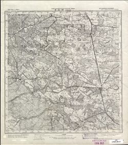
- Description:
- 1926
- Subject:
- Topical Subject: Soviet Union, Topical Subject: Maps, and Geographic Subject: Mohács
- Publisher:
- Генеральный штаб Красной Армии
- Language:
- Russian
- Date Created:
- 1944
- Identifier:
- VAC9619-001479
- Genre:
- Topographic Maps and Military Maps
- Geographic Location:
- Coordinates: 45.6667, 18.5, 46, 19
- Related URL:
- DataCORE Dataset Download: https://datacore.iu.edu/concern/data_sets/cv43nx57x
- Abstract:
- Modern area represented: Mohács, Baranya county, Hungary
- Call Number:
- G7000 s100 .S7 sheet L-34-74
- City:
- Мохач (Mohács)
- Copyright Holder:
- No Copyright - United States
- Country:
- Югославия (Yugoslavia) and Венгрия (Hungary)
- Physical Description:
- Scale: 1:100,000
- Persistent URL:
- http://purl.dlib.indiana.edu/iudl/images/VAC9619/VAC9619-001479
- Provenance:
- DMA Topographic Center, Army Map Service Library, OMAHA, Atlasblatt, Library of Congress Geography & Map Division
-
- Description:
- 1894
- Subject:
- Topical Subject: Soviet Union, Geographic Subject: Szekszárd, and Topical Subject: Maps
- Publisher:
- Генеральный штаб Красной Армии
- Language:
- Russian
- Date Created:
- 1944
- Identifier:
- VAC9619-001477
- Genre:
- Military Maps and Topographic Maps
- Geographic Location:
- Coordinates: 46.3333, 18.5, 46.6667, 19
- Related URL:
- DataCORE Dataset Download: https://datacore.iu.edu/concern/data_sets/s1784m509
- Abstract:
- Modern area represented: Szekszárd, Tolna county, Hungary
- Call Number:
- G7000 s100 .S7 sheet L-34-50
- City:
- Сексард (Szekszárd)
- Copyright Holder:
- No Copyright - United States
- Country:
- Венгрия (Hungary)
- Physical Description:
- Scale: 1:100,000
- Persistent URL:
- http://purl.dlib.indiana.edu/iudl/images/VAC9619/VAC9619-001477
- Provenance:
- DMA Topographic Center, Army Map Service Library, OMAHA, Atlasblatt, Library of Congress Geography & Map Division
-
- Description:
- 1940
- Subject:
- Geographic Subject: Berezhany, Topical Subject: Soviet Union, and Topical Subject: Maps
- Publisher:
- Генеральный штаб Красной Армии
- Language:
- Russian
- Date Created:
- 1944
- Identifier:
- VAC9619-003228
- Genre:
- Topographic Maps and Military Maps
- Geographic Location:
- Coordinates: 49.333, 24.5, 49.667, 25
- Related URL:
- DataCORE Dataset Download: https://datacore.iu.edu/concern/data_sets/rx913q600
- Abstract:
- Modern area represented: Berezhany, Ternopil oblast, Ukraine
- Call Number:
- G7000 s100 .S7 sheet M-35-86
- Caption:
- Для служебного пользования
- City:
- Бережаны (Berezhany)
- Copyright Holder:
- No Copyright - United States
- Country:
- СССР (USSR)
- State/Province:
- Тернопольская область (Ternopil oblast), Украинская ССР (Ukrainian Soviet Socialist Republic), Станиславская область (Stanislav oblast), and Львовская област...
- Physical Description:
- Scale: 1:100,000
- Persistent URL:
- http://purl.dlib.indiana.edu/iudl/images/VAC9619/VAC9619-003228
- Provenance:
- DMA Topographic Center, Army Map Service Library, OMAHA, Geographic Names Branch
-
- Description:
- 1940
- Subject:
- Geographic Subject: Khodoriv, Topical Subject: Maps, and Topical Subject: Soviet Union
- Publisher:
- Генеральный штаб Красной Армии
- Language:
- Russian
- Date Created:
- 1944
- Identifier:
- VAC9619-003227
- Genre:
- Military Maps and Topographic Maps
- Geographic Location:
- Coordinates: 49.333, 24, 49.667, 24.5
- Related URL:
- DataCORE Dataset Download: https://datacore.iu.edu/concern/data_sets/5d86p106z
- Abstract:
- Modern area represented: Khodoriv, Lviv oblast, Ukraine
- Call Number:
- G7000 s100 .S7 sheet M-35-85
- Caption:
- Для служебного пользования
- City:
- Ходоров (Khodoriv)
- Copyright Holder:
- No Copyright - United States
- Country:
- СССР (USSR)
- State/Province:
- Львовская область (Lviv oblast), Станиславская область (Stanislav oblast), Украинская ССР (Ukrainian Soviet Socialist Republic), and Дрогобычская область (Dr...
- Physical Description:
- Scale: 1:100,000
- Persistent URL:
- http://purl.dlib.indiana.edu/iudl/images/VAC9619/VAC9619-003227
- Provenance:
- DMA Topographic Center, Army Map Service Library, OMAHA, Geographic Names Branch
-
- Description:
- 1940
- Subject:
- Geographic Subject: Yavoriv, Topical Subject: Soviet Union, and Topical Subject: Maps
- Publisher:
- Генеральный штаб Красной Армии
- Language:
- Russian
- Date Created:
- 1944
- Identifier:
- VAC9619-003017
- Genre:
- Topographic Maps and Military Maps
- Geographic Location:
- Coordinates: 49.667, 23, 50, 23.5
- Related URL:
- DataCORE Dataset Download: https://datacore.iu.edu/concern/data_sets/1544bp90c
- Abstract:
- Modern area represented: Yavoriv, Lviv oblast, Ukraine
- Call Number:
- G7000 s100 .S7 sheet M-34-83
- Caption:
- Для служебного пользования
- City:
- Яворов (Yavoriv)
- Copyright Holder:
- No Copyright - United States
- Country:
- СССР (USSR)
- State/Province:
- Украинская ССР (Ukrainian Soviet Socialist Republic), Дрогобычская область (Drohobych oblast), and Львовская область (Lviv oblast)
- Physical Description:
- Scale: 1:100,000
- Persistent URL:
- http://purl.dlib.indiana.edu/iudl/images/VAC9619/VAC9619-003017
- Provenance:
- DMA Topographic Center, Army Map Service Library, OMAHA
-
- Description:
- 1874
- Subject:
- Topical Subject: Soviet Union, Topical Subject: Maps, and Geographic Subject: Horodok
- Publisher:
- Генеральный штаб Красной Армии
- Language:
- Russian
- Date Created:
- 1944
- Identifier:
- VAC9619-003019
- Genre:
- Military Maps and Topographic Maps
- Geographic Location:
- Coordinates: 49.667, 23.5, 50, 24
- Related URL:
- DataCORE Dataset Download: https://datacore.iu.edu/concern/data_sets/h702q733w
- Abstract:
- Modern area represented: Horodok, Lviv oblast, Ukraine
- Call Number:
- G7000 s100 .S7 sheet M-34-84
- Caption:
- Для служебного пользования
- City:
- Грудек Ягельоньски (Gródek Jagielloński)
- Copyright Holder:
- No Copyright - United States
- Country:
- СССР (USSR)
- State/Province:
- Львовская область (Lviv oblast) and Украинская ССР (Ukrainian Soviet Socialist Republic)
- Physical Description:
- Scale: 1:100,000
- Persistent URL:
- http://purl.dlib.indiana.edu/iudl/images/VAC9619/VAC9619-003019
- Provenance:
- DMA Topographic Center, Army Map Service Library, OMAHA
-
- Description:
- 1934
- Subject:
- Geographic Subject: Tomaszów Lubelski, Topical Subject: Soviet Union, and Topical Subject: Maps
- Publisher:
- Генеральный штаб Красной Армии
- Language:
- Russian
- Date Created:
- 1944
- Identifier:
- VAC9619-002859
- Genre:
- Military Maps and Topographic Maps
- Geographic Location:
- Coordinates: 50.333, 23, 50.667, 23.5
- Related URL:
- DataCORE Dataset Download: https://datacore.iu.edu/concern/data_sets/pr76f413w
- Abstract:
- Modern area represented: Tomaszów Lubelski, Lublin province, Poland
- Call Number:
- G7000 s100 .S7 sheet M-34-59
- City:
- Томашув (Tomaszów)
- Copyright Holder:
- No Copyright - United States
- Country:
- СССР (USSR) and Польша (Poland)
- State/Province:
- Львовская область (Lviv oblast) and Украинская ССР (Ukrainian Soviet Socialist Republic)
- Physical Description:
- Scale: 1:100,000
- Persistent URL:
- http://purl.dlib.indiana.edu/iudl/images/VAC9619/VAC9619-002859
- Provenance:
- CIA Map Library
-
- Description:
- 1929
- Subject:
- Topical Subject: Maps, Topical Subject: Soviet Union, and Geographic Subject: Sombor
- Publisher:
- Генеральный штаб Красной Армии
- Language:
- Russian
- Date Created:
- 1944
- Identifier:
- VAC9619-001000
- Genre:
- Topographic Maps and Military Maps
- Geographic Location:
- Coordinates: 45.6667, 19, 46, 19.5
- Related URL:
- DataCORE Dataset Download: https://datacore.iu.edu/concern/data_sets/4t64gn82s
- Abstract:
- Modern area represented: Sombor, Vojvodina province, Serbia
- Call Number:
- G7000 s100 .S7 sheet L-34-75
- City:
- Сомбор (Sombor)
- Copyright Holder:
- No Copyright - United States
- Country:
- Югославия (Yugoslavia) and Венгрия (Hungary)
- Physical Description:
- Scale: 1:100,000
- Persistent URL:
- http://purl.dlib.indiana.edu/iudl/images/VAC9619/VAC9619-001000
- Provenance:
- DMA Topographic Center, Army Map Service Library, Library of Congress Geography & Map Division, Atlasblatt
-
- Description:
- 1880
- Subject:
- Topical Subject: Soviet Union, Topical Subject: Maps, and Geographic Subject: Lake Balaton
- Publisher:
- Генеральный штаб Красной Армии
- Language:
- Russian
- Date Created:
- 1944
- Identifier:
- VAC9619-000792
- Genre:
- Military Maps and Topographic Maps
- Geographic Location:
- Coordinates: 46.6667, 17.5, 47, 18
- Related URL:
- DataCORE Dataset Download: https://datacore.iu.edu/concern/data_sets/9p290b049
- Abstract:
- Modern area represented: Lake Balaton, Hungary
- Call Number:
- G7000 s100 .S7 sheet L-33-48
- City:
- Оз. Балатон (Lake Balaton)
- Copyright Holder:
- No Copyright - United States
- Country:
- Венгрия (Hungary)
- Physical Description:
- Scale: 1:100,000
- Persistent URL:
- http://purl.dlib.indiana.edu/iudl/images/VAC9619/VAC9619-000792
- Provenance:
- DMA Topographic Center, Army Map Service Library, OMAHA, Library of Congress Geography & Map Division, Atlasblatt
