
Search Constraints
Search Results
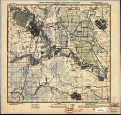
-
- Subject:
- Topical Subject: Soviet Union, Geographic Subject: Pervomayskoye, and Topical Subject: Maps
- Publisher:
- Генеральный штаб Красной Армии
- Language:
- Russian
- Date Created:
- 1941
- Identifier:
- VAC9619-002409
- Genre:
- Military Maps and Topographic Maps
- Geographic Location:
- Coordinates: 60.333, 29.5, 60.667, 30
- Related URL:
- Catalog URL: https://iucat.iu.edu/catalog/5020129 and Download GeoTIFF: https://drive.google.com/file/d/1ZxXZ0CdX_XT_sW3gIQkeCkS0LywCqWv9/view?usp=sharing
- Abstract:
- Modern area represented: Первомайское (Pervomayskoye), Leningradskaya oblast, Russia
- Call Number:
- G7000 s100 .S7 sheet P-35-132
- Caption:
- Для служебного пользования
- City:
- Кивеннапа (Kivennapa)
- Copyright Holder:
- No Copyright - United States
- Country:
- СССР (USSR)
- State/Province:
- РСФСР (RSFSR), Карело-Финская ССР (Karelo-Finnish Soviet Socialist Republic), and Ленинградская область (Leningrad oblast)
- Physical Description:
- Scale: 1:100,000
- Persistent URL:
- http://purl.dlib.indiana.edu/iudl/images/VAC9619/VAC9619-002409
- Provenance:
- DMA Topographic Center, Army Map Service Library, OMAHA
-
- Subject:
- Geographic Subject: Vyborg, Russia, Topical Subject: Maps, and Topical Subject: Soviet Union
- Publisher:
- Генеральный штаб Красной Армии
- Language:
- Russian
- Date Created:
- 1941
- Identifier:
- VAC9619-002395
- Genre:
- Military Maps and Topographic Maps
- Geographic Location:
- Coordinates: 60.667, 28.5, 61, 29
- Related URL:
- Catalog URL: https://iucat.iu.edu/catalog/5020129 and Download GeoTIFF: https://drive.google.com/file/d/1eAU06Lfudrp53eJHHltw9Uur1pzbv5OI/view?usp=sharing
- Abstract:
- Modern area represented: Выборг (Vyborg), Leningradskaya oblast, Russia
- Call Number:
- G7000 s100 .S7 sheet P-35-118
- Caption:
- Для служебного пользования
- City:
- Вийпури (Viipuri)
- Copyright Holder:
- No Copyright - United States
- Country:
- СССР (USSR) and Финляндия (Finland)
- State/Province:
- Карело-Финская ССР (Karelo-Finnish Soviet Socialist Republic)
- Physical Description:
- Scale: 1:100,000
- Persistent URL:
- http://purl.dlib.indiana.edu/iudl/images/VAC9619/VAC9619-002395
- Provenance:
- DMA Topographic Center, Army Map Service Library, OMAHA
-
- Subject:
- Geographic Subject: Simola, Topical Subject: Soviet Union, and Topical Subject: Maps
- Publisher:
- Генеральный штаб Красной Армии
- Language:
- Russian
- Date Created:
- 1941
- Identifier:
- VAC9619-002394
- Genre:
- Military Maps and Topographic Maps
- Geographic Location:
- Coordinates: 60.667, 28, 61, 28.5
- Related URL:
- Catalog URL: https://iucat.iu.edu/catalog/5020129 and Download GeoTIFF: https://drive.google.com/file/d/1x8d6AX08MPXN28yUa645-kxLyeIIBzi2/view?usp=sharing
- Abstract:
- Modern area represented: Simola, Russia
- Call Number:
- G7000 s100 .S7 sheet P-35-117
- City:
- Симола (Simola)
- Copyright Holder:
- No Copyright - United States
- Country:
- СССР (USSR) and Финляндия (Finland)
- State/Province:
- Карело-Финская ССР (Karelo-Finnish Soviet Socialist Republic)
- Physical Description:
- Scale: 1:100,000
- Persistent URL:
- http://purl.dlib.indiana.edu/iudl/images/VAC9619/VAC9619-002394
- Provenance:
- DMA Topographic Center, Army Map Service Library, OMAHA
-
- Subject:
- Topical Subject: Soviet Union, Geographic Subject: Rautjärvi, and Topical Subject: Maps
- Publisher:
- Генеральный штаб Красной Армии
- Language:
- Russian
- Date Created:
- 1941
- Identifier:
- VAC9619-002384
- Genre:
- Military Maps and Topographic Maps
- Geographic Location:
- Coordinates: 61, 29, 61.333, 29.5
- Related URL:
- Catalog URL: https://iucat.iu.edu/catalog/5020129 and Download GeoTIFF: https://drive.google.com/file/d/1Tv4oKVqMLzdmO-ayAuPAJjqvW7QuUIvs/view?usp=sharing
- Abstract:
- Modern area represented: Rautjärvi, Finland
- Call Number:
- G7000 s100 .S7 sheet P-35-107
- Caption:
- Для служебного пользования
- City:
- Раутярви (Rautjärvi)
- Copyright Holder:
- No Copyright - United States
- Country:
- Финляндия (Finland) and СССР (USSR)
- State/Province:
- Карело-Финская ССР (Karelo-Finnish Soviet Socialist Republic)
- Physical Description:
- Scale: 1:100,000
- Persistent URL:
- http://purl.dlib.indiana.edu/iudl/images/VAC9619/VAC9619-002384
- Provenance:
- DMA Topographic Center, Army Map Service Library, University of Kansas Map Library
-
- Description:
- 1940
- Subject:
- Topical Subject: Soviet Union, Geographic Subject: Temirgoyevskaya, and Topical Subject: Maps
- Publisher:
- Генеральный штаб Красной Армии
- Language:
- Russian
- Date Created:
- 1941
- Identifier:
- VAC9619-002362
- Genre:
- Topographic Maps and Military Maps
- Geographic Location:
- Coordinates: 45, 40, 45.333, 40.5
- Related URL:
- Catalog URL: https://iucat.iu.edu/catalog/5020129 and Download GeoTIFF: https://drive.google.com/file/d/1rTvlth-3AjVUPS-mnXQNgc84lXKRMOYU/view?usp=sharing
- Abstract:
- Modern area represented: Temirgoyevskaya, Russia
- Call Number:
- G7000 s100 .S7 sheet L-37-105
- Caption:
- Для служебного пользования
- City:
- Темиргоевская (Temirgoyevskaya)
- Copyright Holder:
- No Copyright - United States
- Country:
- СССР (USSR)
- State/Province:
- Краснодарский край (Krasnodar kray) and РСФСР (RSFSR)
- Physical Description:
- Scale: 1:100,000
- Persistent URL:
- http://purl.dlib.indiana.edu/iudl/images/VAC9619/VAC9619-002362
- Provenance:
- DMA Topographic Center, Army Map Service Library, Auswärtiges Amt. Geographischer Dienst, Library of Congress Geography & Map Division
-
- Description:
- 1940
- Subject:
- Topical Subject: Soviet Union, Geographic Subject: Pashkovskaya, and Topical Subject: Maps
- Publisher:
- Главное управление геодезии и картографии при СНК СССР
- Language:
- Russian
- Date Created:
- 1941
- Identifier:
- VAC9619-002361
- Genre:
- Military Maps and Topographic Maps
- Geographic Location:
- Coordinates: 45, 39, 45.333, 39.5
- Related URL:
- Download GeoTIFF: https://drive.google.com/file/d/1qj8vccZtr5i4G21hUZIBa-EU9JUlKk6w/view?usp=sharing and Catalog URL: https://iucat.iu.edu/catalog/5020129
- Abstract:
- Modern area represented: Pashkovskaya, Russia
- Call Number:
- G7000 s100 .S7 sheet L-37-103
- Caption:
- Для служебного пользования
- City:
- Пашковская (Pashkovskaya)
- Copyright Holder:
- No Copyright - United States
- Country:
- СССР (USSR)
- State/Province:
- Краснодарский край (Krasnodar kray) and РСФСР (RSFSR)
- Physical Description:
- Scale: 1:100,000
- Persistent URL:
- http://purl.dlib.indiana.edu/iudl/images/VAC9619/VAC9619-002361
- Provenance:
- DMA Topographic Center, Army Map Service Library, Heeresplankammer Gruppe Archive Auslandskartenarchiv
-

- Description:
- 1933
- Subject:
- Topical Subject: Soviet Union, Geographic Subject: Taman, and Topical Subject: Maps
- Publisher:
- Генеральный штаб Красной Армии
- Language:
- Russian
- Date Created:
- 1941
- Identifier:
- VAC9619-002358
- Genre:
- Topographic Maps and Military Maps
- Geographic Location:
- Coordinates: 45, 36.5, 45.333, 37
- Related URL:
- Download GeoTIFF: https://drive.google.com/file/d/1X763anMOD-wQf-npLvv0Rk-_nGzkuqHb/view?usp=sharing and Catalog URL: https://iucat.iu.edu/catalog/5020129
- Abstract:
- Modern area represented: Taman, Russia
- Call Number:
- G7000 s100 .S7 sheet L-37-98
- Caption:
- Для служебного пользования
- City:
- Тамань (Taman)
- Copyright Holder:
- No Copyright - United States
- Country:
- СССР (USSR)
- State/Province:
- РСФСР (RSFSR) and Краснодарский край (Krasnodar kray)
- Physical Description:
- Scale: 1:100,000
- Persistent URL:
- http://purl.dlib.indiana.edu/iudl/images/VAC9619/VAC9619-002358
- Provenance:
- DMA Topographic Center, Army Map Service Library, Library of Congress Geography & Map Division
-
- Description:
- 1938
- Subject:
- Topical Subject: Maps, Topical Subject: Soviet Union, and Geographic Subject: Slavyansk-na-Kubani
- Publisher:
- Главное управление геодезии и картографии при СНК СССР
- Language:
- Russian
- Date Created:
- 1941
- Identifier:
- VAC9619-002360
- Genre:
- Topographic Maps and Military Maps
- Geographic Location:
- Coordinates: 45, 38, 45.333, 38.5
- Related URL:
- Catalog URL: https://iucat.iu.edu/catalog/5020129 and Download GeoTIFF: https://drive.google.com/file/d/1dDVpO5eXZ3hvJ1_1_fgMwdPJLC9kNLZ3/view?usp=sharing
- Abstract:
- Modern area represented: Slavyansk-na-Kubani, Russia
- Call Number:
- G7000 s100 .S7 sheet L-37-101
- Caption:
- Для служебного пользования
- City:
- Славянская (Slavyanskaya)
- Copyright Holder:
- No Copyright - United States
- Country:
- СССР (USSR)
- State/Province:
- РСФСР (RSFSR) and Краснодарский край (Krasnodar kray)
- Physical Description:
- Scale: 1:100,000
- Persistent URL:
- http://purl.dlib.indiana.edu/iudl/images/VAC9619/VAC9619-002360
- Provenance:
- CIA Map Library, Library of Congress Geography & Map Division
-
- Description:
- 1933
- Subject:
- Geographic Subject: Marfovka, Topical Subject: Maps, and Topical Subject: Soviet Union
- Publisher:
- Генеральный штаб Красной Армии
- Language:
- Russian
- Date Created:
- 1941
- Identifier:
- VAC9619-002357
- Genre:
- Topographic Maps and Military Maps
- Geographic Location:
- Coordinates: 45, 36, 45.333, 36.5
- Related URL:
- Download GeoTIFF: https://drive.google.com/file/d/1hKpSFk-K4fu5BS1aNKraUirebYIlnwMd/view?usp=sharing and Catalog URL: https://iucat.iu.edu/catalog/5020129
- Abstract:
- Modern area represented: Marfovka, Autonomous Republic of Crimea, Ukraine
- Call Number:
- G7000 s100 .S7 sheet L-37-97
- Caption:
- Для служебного пользования
- City:
- Марфовка (Marfovka)
- Copyright Holder:
- No Copyright - United States
- Country:
- СССР (USSR)
- State/Province:
- РСФСР (RSFSR) and Крымская АССР (Crimean Autonomous Soviet Socialist Republic)
- Physical Description:
- Scale: 1:100,000
- Persistent URL:
- http://purl.dlib.indiana.edu/iudl/images/VAC9619/VAC9619-002357
- Provenance:
- DMA Topographic Center, Army Map Service Library, OMAHA, Library of Congress Geography & Map Division
-
- Description:
- 1938
- Subject:
- Geographic Subject: Novoaleksandrovsk, Topical Subject: Soviet Union, and Topical Subject: Maps
- Publisher:
- Главное управление геодезии и картографии при СНК СССР
- Language:
- Russian
- Date Created:
- 1941
- Identifier:
- VAC9619-002355
- Genre:
- Military Maps and Topographic Maps
- Geographic Location:
- Coordinates: 45.333, 41, 45.667, 41.5
- Related URL:
- Download GeoTIFF: https://drive.google.com/file/d/1pHbZkYK-CXplWOsf-Aed6999hiTFM3zQ/view?usp=sharing and Catalog URL: https://iucat.iu.edu/catalog/5020129
- Abstract:
- Modern area represented: Novoaleksandrovsk, Stavropol kray, Russia
- Call Number:
- G7000 s100 .S7 sheet L-37-95
- Caption:
- Для служебного пользования
- City:
- Новоалександровская (Novoaleksandrovskaya)
- Copyright Holder:
- No Copyright - United States
- Country:
- СССР (USSR)
- State/Province:
- РСФСР (RSFSR) and Орджоникидзевский край (Ordzhonikidze kray)
- Physical Description:
- Scale: 1:100,000
- Persistent URL:
- http://purl.dlib.indiana.edu/iudl/images/VAC9619/VAC9619-002355
- Provenance:
- DMA Topographic Center, Army Map Service Library, Heeresplankammer Gruppe Archive Auslandskartenarchiv, Library of Congress Geography & Map Division, Atl...
