
Search Constraints
You searched for:
Type
Image
Remove constraint Type: Image
State/Province
Украинская ССР (Ukrainian Soviet Socialist Republic)
Remove constraint State/Province: Украинская ССР (Ukrainian Soviet Socialist Republic)
« Previous |
1 - 10 of 566
|
Next »
Search Results
-
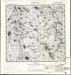
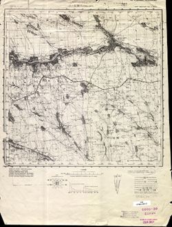
- Description:
- 1873
- Subject:
- Topical Subject: Maps, Topical Subject: Soviet Union, and Geographic Subject: Slobidka
- Publisher:
- Генеральный штаб РККА
- Language:
- Russian
- Date Created:
- 1933
- Identifier:
- VAC9619-001502
- Genre:
- Military Maps and Topographic Maps
- Geographic Location:
- Coordinates: 47.6667, 29, 48, 29.5
- Related URL:
- Download GeoTIFF: https://drive.google.com/open?id=12hPOl2XNIpsYO7n4_yTuCA5VYkAUpSEV and Catalog URL: https://iucat.iu.edu/catalog/5020129
- Abstract:
- Modern area represented: Slobidka, Odessa oblast, Ukraine
- Call Number:
- G7000 s100 .S7 sheet L-35-11
- Caption:
- Не подлежит оглашению
- City:
- Пос. Слободка (Slobodka village)
- Copyright Holder:
- No Copyright - United States
- State/Province:
- Украинская ССР (Ukrainian Soviet Socialist Republic), Бессарабия (Bessarabia), and Молдавская АССР (Moldavian Autonomous Soviet Socialist Republic)
- Physical Description:
- Scale: 1:100,000
- Persistent URL:
- http://purl.dlib.indiana.edu/iudl/images/VAC9619/VAC9619-001502
- Provenance:
- CIA Map Library
-
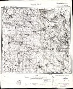
- Description:
- 1914
- Subject:
- Topical Subject: Maps, Topical Subject: Soviet Union, and Geographic Subject: Podilsk
- Publisher:
- Управление военных топографов РККА
- Language:
- Russian
- Date Created:
- 1932
- Identifier:
- VAC9619-001503
- Genre:
- Topographic Maps and Military Maps
- Geographic Location:
- Coordinates: 47.6667, 29.5, 48, 30
- Related URL:
- Catalog URL: https://iucat.iu.edu/catalog/5020129 and Download GeoTIFF: https://drive.google.com/open?id=1GY1T_2cRAKuBJomRz9ZEfhqJTuF0vfG8
- Abstract:
- Modern area represented: Podilsk, Odessa oblast, Ukraine
- Call Number:
- G7000 s100 .S7 sheet L-35-12
- Caption:
- Не подлежит оглашению
- City:
- Котовск (Kotovsk)
- Copyright Holder:
- No Copyright - United States
- Country:
- СССР (USSR)
- State/Province:
- Одесская область (Odessa oblast), Украинская ССР (Ukrainian Soviet Socialist Republic), and Молдавская АССР (Moldavian Autonomous Soviet Socialist Republic)
- Physical Description:
- Scale: 1:100,000
- Persistent URL:
- http://purl.dlib.indiana.edu/iudl/images/VAC9619/VAC9619-001503
- Provenance:
- CIA Map Library, Auswärtiges Amt. Geographischer Dienst
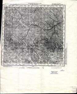
-
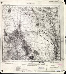
- Description:
- 1914
- Subject:
- Geographic Subject: Podilsk, Topical Subject: Maps, and Topical Subject: Soviet Union
- Publisher:
- Управление военных топографов РККА
- Language:
- Russian
- Date Created:
- 1932
- Identifier:
- VAC9619-001507
- Genre:
- Topographic Maps and Military Maps
- Geographic Location:
- Coordinates: 47.6667, 29.5, 48, 30
- Related URL:
- Download GeoTIFF: https://drive.google.com/file/d/1yoB4gIhyBxqMxVG2YSUt4dy0IT4GLUCb/view?usp=sharing and Catalog URL: https://iucat.iu.edu/catalog/5020129
- Abstract:
- Modern area represented: Podilsk, Odessa oblast, Ukraine
- Call Number:
- G7000 s100 .S7 sheet L-35-12
- Caption:
- Не подлежит оглашению
- City:
- Котовск (Kotovsk)
- Copyright Holder:
- No Copyright - United States
- Country:
- СССР (USSR)
- State/Province:
- Украинская ССР (Ukrainian Soviet Socialist Republic), Одесская область (Odessa oblast), and Молдавская АССР (Moldavian Autonomous Soviet Socialist Republic)
- Physical Description:
- Scale: 1:100,000
- Persistent URL:
- http://purl.dlib.indiana.edu/iudl/images/VAC9619/VAC9619-001507
- Provenance:
- DMA Topographic Center, Army Map Service Library, OMAHA, Library of Congress Geography & Map Division, Auswärtiges Amt. Geographischer Dienst
-
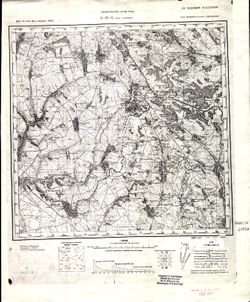
- Description:
- 1873
- Subject:
- Geographic Subject: Selyatyn, Topical Subject: Maps, and Topical Subject: Soviet Union
- Publisher:
- Генеральный штаб Красной Армии
- Language:
- Russian
- Date Created:
- 1939
- Identifier:
- VAC9619-001472
- Genre:
- Military Maps and Topographic Maps
- Geographic Location:
- Coordinates: 47.6667, 25, 48, 25.5
- Related URL:
- Download GeoTIFF: https://drive.google.com/open?id=1v6zIUxpzw2mb5AD7jE4-hVpFfWBpe8B8 and Catalog URL: https://iucat.iu.edu/catalog/5020129
- Abstract:
- Modern area represented: Selyatyn, Chernivtsi oblast, Ukraine
- Call Number:
- G7000 s100 .S7 sheet L-35-3
- Caption:
- Для служебного пользования
- City:
- Селетин (Selyatyn)
- Copyright Holder:
- No Copyright - United States
- Country:
- Румыния (Romania)
- State/Province:
- Украинская ССР (Ukrainian Soviet Socialist Republic) and Черновицкая область (Chernivtsi oblast)
- Physical Description:
- Scale: 1:100,000
- Persistent URL:
- http://purl.dlib.indiana.edu/iudl/images/VAC9619/VAC9619-001472
- Provenance:
- CIA Map Library
-
- Description:
- 1874
- Subject:
- Topical Subject: Soviet Union, Geographic Subject: Hryhoriopol, and Topical Subject: Maps
- Publisher:
- Генеральный штаб РККА
- Language:
- Russian
- Date Created:
- 1916
- Identifier:
- VAC9619-001531
- Genre:
- Military Maps and Topographic Maps
- Geographic Location:
- Coordinates: 47, 29, 47.3333, 29.5
- Related URL:
- Download GeoTIFF: https://drive.google.com/open?id=19E1iGxfkWQpzLaVEysUOs-ieDNfm5LYO and Catalog URL: https://iucat.iu.edu/catalog/5020129
- Abstract:
- Modern area represented: Hryhoriopol, Stînga Nistrului, Moldova
- Call Number:
- G7000 s100 .S7 sheet L-35-35
- Caption:
- Не подлежит оглашению
- City:
- Григориополь (Hryhoriopol)
- Copyright Holder:
- No Copyright - United States
- State/Province:
- Бессарабия (Bessarabia), Молдавская АССР (Moldavian Autonomous Soviet Socialist Republic), and Украинская ССР (Ukrainian Soviet Socialist Republic)
- Physical Description:
- Scale: 1:100,000
- Persistent URL:
- http://purl.dlib.indiana.edu/iudl/images/VAC9619/VAC9619-001531
- Provenance:
- DMA Topographic Center, Army Map Service Library, Library of Congress Geography & Map Division
-
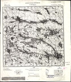
- Description:
- 1914
- Subject:
- Topical Subject: Maps, Topical Subject: Soviet Union, and Geographic Subject: Grosulovo
- Publisher:
- Генеральный штаб РККА
- Language:
- Russian
- Date Created:
- 1933
- Identifier:
- VAC9619-001532
- Genre:
- Military Maps and Topographic Maps
- Geographic Location:
- Coordinates: 47, 29.5, 47.3333, 30
- Related URL:
- Download GeoTIFF: https://drive.google.com/open?id=1kyU5R5m-tJespCHRUtLSwhXDplcG5011 and Catalog URL: https://iucat.iu.edu/catalog/5020129
- Abstract:
- Modern area represented: Grosulovo, Odessa oblast, Ukraine
- Call Number:
- G7000 s100 .S7 sheet L-35-36
- Caption:
- Не подлежит оглашению
- City:
- Гросулово (Grosulovo)
- Copyright Holder:
- No Copyright - United States
- State/Province:
- Молдавская АССР (Moldavian Autonomous Soviet Socialist Republic), Украинская ССР (Ukrainian Soviet Socialist Republic), and Одесская область (Odessa oblast)
- Physical Description:
- Scale: 1:100,000
- Persistent URL:
- http://purl.dlib.indiana.edu/iudl/images/VAC9619/VAC9619-001532
- Provenance:
- CIA Map Library, Atlasblatt
-
- Description:
- 1875
- Subject:
- Topical Subject: Maps, Topical Subject: Soviet Union, and Geographic Subject: Tighina
- Publisher:
- Генеральный штаб РККА
- Language:
- Russian
- Date Created:
- 1940
- Identifier:
- VAC9619-001549
- Genre:
- Military Maps and Topographic Maps
- Geographic Location:
- Coordinates: 46.6667, 29, 47, 29.5
- Related URL:
- Catalog URL: https://iucat.iu.edu/catalog/5020129 and Download GeoTIFF: https://drive.google.com/open?id=1MZ4PrCBw5im-5F634wMbg7bDcKcTTsDN
- Abstract:
- Modern area represented: Tighina, Bender municipality, Moldova
- Call Number:
- G7000 s100 .S7 sheet L-35-47
- Caption:
- Не подлежит оглашению
- City:
- Бендеры (Bendery)
- Copyright Holder:
- No Copyright - United States
- State/Province:
- Бессарабия (Bessarabia), Украинская ССР (Ukrainian Soviet Socialist Republic), and Молдавская АССР (Moldavian Autonomous Soviet Socialist Republic)
- Physical Description:
- Scale: 1:100,000
- Persistent URL:
- http://purl.dlib.indiana.edu/iudl/images/VAC9619/VAC9619-001549
- Provenance:
- CIA Map Library, Geographisches Institut der Universität Berlin
-
- Description:
- 1875
- Subject:
- Topical Subject: Soviet Union, Geographic Subject: Tiraspol, and Topical Subject: Maps
- Publisher:
- Генеральный штаб РККА
- Language:
- Russian
- Date Created:
- 1929
- Identifier:
- VAC9619-001718
- Genre:
- Military Maps and Topographic Maps
- Geographic Location:
- Coordinates: 46.6667, 29.5, 47, 30
- Related URL:
- Catalog URL: https://iucat.iu.edu/catalog/5020129 and Download GeoTIFF: https://drive.google.com/open?id=1-hf6LeF3eCsdwqOwg-k3BLxRce9hfH9t
- Abstract:
- Modern area represented: Tiraspol, Stînga Nistrului, Moldova
- Call Number:
- G7000 s100 .S7 sheet L-35-48
- Caption:
- Не подлежит оглашению
- City:
- Тирасполь (Tiraspol)
- Copyright Holder:
- No Copyright - United States
- State/Province:
- Украинская ССР (Ukrainian Soviet Socialist Republic), Молдавская АССР (Moldavian Autonomous Soviet Socialist Republic), Бессарабия (Bessarabia), and Одесская...
- Physical Description:
- Scale: 1:100,000
- Persistent URL:
- http://purl.dlib.indiana.edu/iudl/images/VAC9619/VAC9619-001718
- Provenance:
- CIA Map Library
-
- Description:
- 1875
- Subject:
- Geographic Subject: Volintiri, Topical Subject: Soviet Union, and Topical Subject: Maps
- Publisher:
- Генеральный штаб РККА
- Language:
- Russian
- Date Created:
- 1940
- Identifier:
- VAC9619-001581
- Genre:
- Topographic Maps and Military Maps
- Geographic Location:
- Coordinates: 46.3333, 29.5, 46.6667, 30
- Related URL:
- Download GeoTIFF: https://drive.google.com/open?id=1yjBpyWEhLGUL0b_IOaIHHjcBR0P7r7Hi and Catalog URL: https://iucat.iu.edu/catalog/5020129
- Abstract:
- Modern area represented: Volintiri, Ștefan Vodă district, Moldova
- Call Number:
- G7000 s100 .S7 sheet L-35-60
- Caption:
- Не подлежит оглашению
- City:
- Волинтирь (Volintiri)
- Copyright Holder:
- No Copyright - United States
- Country:
- СССР (USSR)
- State/Province:
- Украинская ССР (Ukrainian Soviet Socialist Republic), Одесская область (Odessa oblast), Молдавская АССР (Moldavian Autonomous Soviet Socialist Republic), and...
- Physical Description:
- Scale: 1:100,000
- Persistent URL:
- http://purl.dlib.indiana.edu/iudl/images/VAC9619/VAC9619-001581
- Provenance:
- Library of Congress Geography & Map Division, Atlasblatt, DMA Topographic Center, Army Map Service Library, OMAHA
-
- Description:
- 1927
- Subject:
- Topical Subject: Soviet Union, Topical Subject: Maps, and Geographic Subject: Kryve Ozero
- Publisher:
- Генеральный штаб РККА
- Language:
- Russian
- Date Created:
- 1933
- Identifier:
- VAC9619-001860
- Genre:
- Topographic Maps and Military Maps
- Geographic Location:
- Coordinates: 47.6667, 30, 48, 30.5
- Related URL:
- Catalog URL: https://iucat.iu.edu/catalog/5020129 and Download GeoTIFF: https://drive.google.com/open?id=1hbij6lPaIDBZ6sv_u07NP2w2I0N9ow8M
- Abstract:
- Modern area represented: Kryve Ozero, Mykolaiv oblast, Ukraine
- Call Number:
- G7000 s100 .S7 sheet L-36-1
- Caption:
- Не подлежит оглашению
- City:
- Кривое Озеро (Kryve Ozero)
- Copyright Holder:
- No Copyright - United States
- Country:
- СССР (USSR)
- State/Province:
- Украинская ССР (Ukrainian Soviet Socialist Republic), Одесская область (Odessa oblast), and Молдавская АССР (Moldavian Autonomous Soviet Socialist Republic)
- Physical Description:
- Scale: 1:100,000
- Persistent URL:
- http://purl.dlib.indiana.edu/iudl/images/VAC9619/VAC9619-001860
- Provenance:
- CIA Map Library, Atlasblatt
