
Search Constraints
You searched for:
Date Created
1932
Remove constraint Date Created: 1932
State/Province
Украинская ССР (Ukrainian Soviet Socialist Republic)
Remove constraint State/Province: Украинская ССР (Ukrainian Soviet Socialist Republic)
« Previous |
1 - 10 of 31
|
Next »
Search Results
-
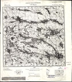
- Description:
- 1914
- Subject:
- Topical Subject: Maps, Topical Subject: Soviet Union, and Geographic Subject: Podilsk
- Publisher:
- Управление военных топографов РККА
- Language:
- Russian
- Date Created:
- 1932
- Identifier:
- VAC9619-001503
- Genre:
- Topographic Maps and Military Maps
- Geographic Location:
- Coordinates: 47.6667, 29.5, 48, 30
- Related URL:
- Catalog URL: https://iucat.iu.edu/catalog/5020129 and Download GeoTIFF: https://drive.google.com/open?id=1GY1T_2cRAKuBJomRz9ZEfhqJTuF0vfG8
- Abstract:
- Modern area represented: Podilsk, Odessa oblast, Ukraine
- Call Number:
- G7000 s100 .S7 sheet L-35-12
- Caption:
- Не подлежит оглашению
- City:
- Котовск (Kotovsk)
- Copyright Holder:
- No Copyright - United States
- Country:
- СССР (USSR)
- State/Province:
- Одесская область (Odessa oblast), Украинская ССР (Ukrainian Soviet Socialist Republic), and Молдавская АССР (Moldavian Autonomous Soviet Socialist Republic)
- Physical Description:
- Scale: 1:100,000
- Persistent URL:
- http://purl.dlib.indiana.edu/iudl/images/VAC9619/VAC9619-001503
- Provenance:
- CIA Map Library, Auswärtiges Amt. Geographischer Dienst
-
- Description:
- 1914
- Subject:
- Geographic Subject: Podilsk, Topical Subject: Maps, and Topical Subject: Soviet Union
- Publisher:
- Управление военных топографов РККА
- Language:
- Russian
- Date Created:
- 1932
- Identifier:
- VAC9619-001507
- Genre:
- Topographic Maps and Military Maps
- Geographic Location:
- Coordinates: 47.6667, 29.5, 48, 30
- Related URL:
- Download GeoTIFF: https://drive.google.com/file/d/1yoB4gIhyBxqMxVG2YSUt4dy0IT4GLUCb/view?usp=sharing and Catalog URL: https://iucat.iu.edu/catalog/5020129
- Abstract:
- Modern area represented: Podilsk, Odessa oblast, Ukraine
- Call Number:
- G7000 s100 .S7 sheet L-35-12
- Caption:
- Не подлежит оглашению
- City:
- Котовск (Kotovsk)
- Copyright Holder:
- No Copyright - United States
- Country:
- СССР (USSR)
- State/Province:
- Украинская ССР (Ukrainian Soviet Socialist Republic), Одесская область (Odessa oblast), and Молдавская АССР (Moldavian Autonomous Soviet Socialist Republic)
- Physical Description:
- Scale: 1:100,000
- Persistent URL:
- http://purl.dlib.indiana.edu/iudl/images/VAC9619/VAC9619-001507
- Provenance:
- DMA Topographic Center, Army Map Service Library, OMAHA, Library of Congress Geography & Map Division, Auswärtiges Amt. Geographischer Dienst
-
- Description:
- 1927
- Subject:
- Topical Subject: Soviet Union, Geographic Subject: Vradiyivka, and Topical Subject: Maps
- Publisher:
- Генеральный штаб РККА
- Language:
- Russian
- Date Created:
- 1932
- Identifier:
- VAC9619-001861
- Genre:
- Topographic Maps and Military Maps
- Geographic Location:
- Coordinates: 47.6667, 30.5, 48, 31
- Related URL:
- Catalog URL: https://iucat.iu.edu/catalog/5020129 and Download GeoTIFF: https://drive.google.com/open?id=1qq27-b3PwdUCvrlOONE9iPfRjsP8GlqJ
- Abstract:
- Modern area represented: Vradiyivka, Mykolaiv oblast, Ukraine
- Call Number:
- G7000 s100 .S7 sheet L-36-2
- Caption:
- Не подлежит оглашению
- City:
- М.Врадиевка (M.Vradiyivka)
- Copyright Holder:
- No Copyright - United States
- Country:
- СССР (USSR)
- State/Province:
- Украинская ССР (Ukrainian Soviet Socialist Republic) and Одесская область (Odessa oblast)
- Physical Description:
- Scale: 1:100,000
- Persistent URL:
- http://purl.dlib.indiana.edu/iudl/images/VAC9619/VAC9619-001861
- Provenance:
- CIA Map Library, Atlasblatt, Library of Congress Geography & Map Division
-
- Description:
- 1923
- Subject:
- Topical Subject: Soviet Union, Topical Subject: Maps, and Geographic Subject: Muzykivka
- Publisher:
- Управление военных топографов
- Language:
- Russian
- Date Created:
- 1932
- Identifier:
- VAC9619-000112
- Genre:
- Topographic Maps and Military Maps
- Geographic Location:
- Coordinates: 46.6667, 32.5, 46.8333, 32.75
- Related URL:
- Download GeoTIFF: https://drive.google.com/open?id=1A5o-Kqp26rf9TRg8ozzR-mwjPqVtK8iH and Catalog URL: http://iucat.iu.edu/catalog/5020131
- Abstract:
- Modern area represented: Muzykivka, Kherson oblast, Ukraine
- Call Number:
- G7000 s50 .S68 sheet L-36-42-C
- Caption:
- Не подлежит оглашению,Секретно
- City:
- Музыковка (Muzykovka)
- Copyright Holder:
- No Copyright - United States
- Country:
- СССР (USSR)
- State/Province:
- Украинская ССР (Ukrainian Soviet Socialist Republic)
- Physical Description:
- Scale: 1:50,000
- Persistent URL:
- http://purl.dlib.indiana.edu/iudl/images/VAC9619/VAC9619-000112
- Provenance:
- DMA Topographic Center, Army Map Service Library, OMAHA, Library of Congress Geography & Map Division
-
- Description:
- 1910
- Subject:
- Topical Subject: Maps, Geographic Subject: Khrystynivka, and Topical Subject: Soviet Union
- Publisher:
- Управление военных топографов РККА
- Language:
- Russian
- Date Created:
- 1932
- Identifier:
- VAC9619-003244
- Genre:
- Topographic Maps and Military Maps
- Geographic Location:
- Coordinates: 48.667, 29.5, 49, 30
- Related URL:
- Catalog URL: https://iucat.iu.edu/catalog/5020129 and Download GeoTIFF: https://drive.google.com/file/d/18XiPWIGh6qpclep03S-jZjfpBuTFbG9-/view?usp=sharing
- Abstract:
- Modern area represented: Khrystynivka, Cherkasy oblast, Ukraine
- Call Number:
- G7000 s100 .S7 sheet M-35-120
- Caption:
- Не подлежит оглашению
- City:
- Христинивка (Khrystynivka)
- Copyright Holder:
- No Copyright - United States
- Country:
- СССР (USSR)
- State/Province:
- Украинская ССР (Ukrainian Soviet Socialist Republic), Винницкая область (Vinnytsia oblast), and Киевская область (Kyiv oblast)
- Physical Description:
- Scale: 1:100,000
- Persistent URL:
- http://purl.dlib.indiana.edu/iudl/images/VAC9619/VAC9619-003244
- Provenance:
- DMA Topographic Center, Army Map Service Library, Library of Congress Geography & Map Division, Atlasblatt
-
- Subject:
- Geographic Subject: Kylykyiv, Topical Subject: Soviet Union, and Topical Subject: Maps
- Publisher:
- Управление военных топографов РККА
- Language:
- Russian
- Date Created:
- 1932
- Identifier:
- VAC9619-000222
- Genre:
- Topographic Maps and Military Maps
- Geographic Location:
- Coordinates: 50.5, 27, 50.667, 27.25
- Related URL:
- Download GeoTIFF: https://drive.google.com/open?id=1Y9wUaxz3y48-qxkJlwKX7xLRzY0AHUBF and Catalog URL: http://iucat.iu.edu/catalog/5020131
- Abstract:
- Modern area represented: Kylykyiv, Khmelnytskyi oblast, Ukraine
- Call Number:
- G7000 s50 .S68 sheet M-35-55-A
- Caption:
- Не подлежит оглашению
- City:
- Киликиев (Kilikiyev)
- Copyright Holder:
- No Copyright - United States
- Country:
- СССР (USSR) and Польша (Poland)
- State/Province:
- Киевская область (Kyiv oblast) and Украинская ССР (Ukrainian Soviet Socialist Republic)
- Physical Description:
- Scale: 1:50,000
- Persistent URL:
- http://purl.dlib.indiana.edu/iudl/images/VAC9619/VAC9619-000222
- Provenance:
- DMA Topographic Center, Army Map Service Library, OMAHA, Library of Congress Geography & Map Division
-
- Description:
- 1907
- Subject:
- Geographic Subject: Dovbysh, Topical Subject: Maps, and Topical Subject: Soviet Union
- Publisher:
- Управление военных топографов РККА
- Language:
- Russian
- Date Created:
- 1932
- Identifier:
- VAC9619-000226
- Genre:
- Military Maps and Topographic Maps
- Geographic Location:
- Coordinates: 50.333, 27.75, 50.5, 28
- Related URL:
- Download GeoTIFF: https://drive.google.com/open?id=1ljvwmMWe-E8NE0bQ7bmBUNbEqBi75_sS and Catalog URL: http://iucat.iu.edu/catalog/5020131
- Abstract:
- Modern area represented: Dovbysh, Zhytomyr oblast, Ukraine
- Call Number:
- G7000 s50 .S68 sheet M-34-56-D
- Caption:
- Не подлежит оглашению,Captured map
- City:
- Мархлевск (Markhlevsk)
- Copyright Holder:
- No Copyright - United States
- Country:
- СССР (USSR)
- State/Province:
- Киевская область (Kyiv oblast) and Украинская ССР (Ukrainian Soviet Socialist Republic)
- Physical Description:
- Scale: 1:50,000
- Persistent URL:
- http://purl.dlib.indiana.edu/iudl/images/VAC9619/VAC9619-000226
- Provenance:
- DMA Topographic Center, Army Map Service Library, Library of Congress Geography & Map Division
-
- Description:
- 1908
- Subject:
- Topical Subject: Soviet Union, Topical Subject: Maps, and Geographic Subject: Chudniv
- Publisher:
- Управление военных топографов РККА
- Language:
- Russian
- Date Created:
- 1932
- Identifier:
- VAC9619-003223
- Genre:
- Topographic Maps and Military Maps
- Geographic Location:
- Coordinates: 50, 28, 50.333, 28.5
- Related URL:
- Catalog URL: https://iucat.iu.edu/catalog/5020129 and Download GeoTIFF: https://drive.google.com/file/d/1SkZk5hQRmHL7hW9Yn3FqmEo2eW42Cg9c/view?usp=sharing
- Abstract:
- Modern area represented: Chudniv, Zhytomyr oblast, Ukraine
- Call Number:
- G7000 s100 .S7 sheet M-35-69
- Caption:
- Не подлежит оглашению
- City:
- Чуднов (Chudniv)
- Copyright Holder:
- No Copyright - United States
- Country:
- СССР (USSR)
- State/Province:
- Винницкая область (Vinnytsia oblast), Украинская ССР (Ukrainian Soviet Socialist Republic), and Киевская область (Kyiv oblast)
- Physical Description:
- Scale: 1:100,000
- Persistent URL:
- http://purl.dlib.indiana.edu/iudl/images/VAC9619/VAC9619-003223
- Provenance:
- DMA Topographic Center, Army Map Service Library, OMAHA, Library of Congress Geography & Map Division
-
- Description:
- 1903
- Subject:
- Topical Subject: Soviet Union, Geographic Subject: Starokostiantyniv, and Topical Subject: Maps
- Publisher:
- Генеральный штаб РККА
- Language:
- Russian
- Date Created:
- 1932
- Identifier:
- VAC9619-003224
- Genre:
- Military Maps and Topographic Maps
- Geographic Location:
- Coordinates: 49.667, 27, 50, 27.5
- Related URL:
- Download GeoTIFF: https://drive.google.com/file/d/1WZ-h8zC8CR1miztk7aJtZNqur3A6_XAm/view?usp=sharing and Catalog URL: https://iucat.iu.edu/catalog/5020129
- Abstract:
- Modern area represented: Starokostiantyniv, Khmelnytskyi oblast, Ukraine
- Call Number:
- G7000 s100 .S7 sheet M-35-79
- Caption:
- Не подлежит оглашению
- City:
- Старо-Константинов (Staro-Kostiantyniv)
- Copyright Holder:
- No Copyright - United States
- Country:
- СССР (USSR)
- State/Province:
- Каменец-Подольская область (Kamianets-Podilskyi oblast) and Украинская ССР (Ukrainian Soviet Socialist Republic)
- Physical Description:
- Scale: 1:100,000
- Persistent URL:
- http://purl.dlib.indiana.edu/iudl/images/VAC9619/VAC9619-003224
- Provenance:
- DMA Topographic Center, Army Map Service Library, OMAHA, Library of Congress Geography & Map Division
-
- Description:
- 1908
- Subject:
- Geographic Subject: Ivanopil, Topical Subject: Maps, and Topical Subject: Soviet Union
- Publisher:
- Генеральный штаб РККА
- Language:
- Russian
- Date Created:
- 1932
- Identifier:
- VAC9619-003225
- Genre:
- Topographic Maps and Military Maps
- Geographic Location:
- Coordinates: 49.667, 28, 50, 28.5
- Related URL:
- Download GeoTIFF: https://drive.google.com/file/d/13cB2CWX34igKnSOA3rnHUd15TRlKohbf/view?usp=sharing and Catalog URL: https://iucat.iu.edu/catalog/5020129
- Abstract:
- Modern area represented: Ivanopil, Zhytomyr oblast, Ukraine
- Call Number:
- G7000 s100 .S7 sheet M-35-81
- Caption:
- Не подлежит оглашению
- City:
- Янушпиль (Janushpil)
- Copyright Holder:
- No Copyright - United States
- Country:
- СССР (USSR)
- State/Province:
- Украинская ССР (Ukrainian Soviet Socialist Republic), Житомирская область (Zhytomyr oblast), and Винницкая область (Vinnytsia oblast)
- Physical Description:
- Scale: 1:100,000
- Persistent URL:
- http://purl.dlib.indiana.edu/iudl/images/VAC9619/VAC9619-003225
- Provenance:
- DMA Topographic Center, Army Map Service Library, OMAHA

- « Previous
- Next »
- 1
- 2
- 3
- 4