
Search Constraints
You searched for:
State/Province
Украинская ССР (Ukrainian Soviet Socialist Republic)
Remove constraint State/Province: Украинская ССР (Ukrainian Soviet Socialist Republic)
State/Province
Винницкая область (Vinnytsia oblast)
Remove constraint State/Province: Винницкая область (Vinnytsia oblast)
1 - 38 of 38
Search Results
-
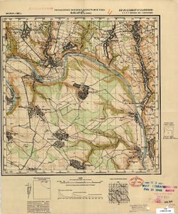
- Description:
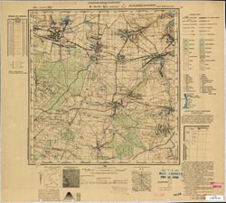
- 1910
- Subject:
- Topical Subject: Maps, Geographic Subject: Khrystynivka, and Topical Subject: Soviet Union
- Publisher:
- Управление военных топографов РККА
- Language:
- Russian
- Date Created:
- 1932
- Identifier:
- VAC9619-003244
- Genre:
- Topographic Maps and Military Maps
- Geographic Location:
- Coordinates: 48.667, 29.5, 49, 30
- Related URL:
- Catalog URL: https://iucat.iu.edu/catalog/5020129 and Download GeoTIFF: https://drive.google.com/file/d/18XiPWIGh6qpclep03S-jZjfpBuTFbG9-/view?usp=sharing
- Abstract:
- Modern area represented: Khrystynivka, Cherkasy oblast, Ukraine
- Call Number:
- G7000 s100 .S7 sheet M-35-120
- Caption:
- Не подлежит оглашению
- City:
- Христинивка (Khrystynivka)
- Copyright Holder:
- No Copyright - United States
- Country:
- СССР (USSR)
- State/Province:
- Украинская ССР (Ukrainian Soviet Socialist Republic), Винницкая область (Vinnytsia oblast), and Киевская область (Kyiv oblast)
- Physical Description:
- Scale: 1:100,000
- Persistent URL:
- http://purl.dlib.indiana.edu/iudl/images/VAC9619/VAC9619-003244
- Provenance:
- DMA Topographic Center, Army Map Service Library, Library of Congress Geography & Map Division, Atlasblatt
-
- Description:
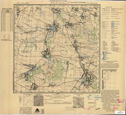
- 1910
- Subject:
- Geographic Subject: Sharhorod, Topical Subject: Soviet Union, and Topical Subject: Maps
- Publisher:
- Генеральный штаб Красной Армии
- Language:
- Russian
- Date Created:
- 1933
- Identifier:
- VAC9619-003243
- Genre:
- Topographic Maps and Military Maps
- Geographic Location:
- Coordinates: 48.667, 28, 49, 28.5
- Related URL:
- Catalog URL: https://iucat.iu.edu/catalog/5020129 and Download GeoTIFF: https://drive.google.com/file/d/1eXbG8jlG1VAmkShBED_fiZOoPN31kXP8/view?usp=sharing
- Abstract:
- Modern area represented: Sharhorod, Vinnytsia oblast, Ukraine
- Call Number:
- G7000 s100 .S7 sheet M-35-117
- Caption:
- Для служебного пользования
- City:
- Шаргород (Sharhorod)
- Copyright Holder:
- No Copyright - United States
- Country:
- СССР (USSR)
- State/Province:
- Украинская ССР (Ukrainian Soviet Socialist Republic) and Винницкая область (Vinnytsia oblast)
- Physical Description:
- Scale: 1:100,000
- Persistent URL:
- http://purl.dlib.indiana.edu/iudl/images/VAC9619/VAC9619-003243
- Provenance:
- DMA Topographic Center, Army Map Service Library, OMAHA, Library of Congress Geography & Map Division
-
- Description:
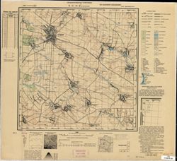
- 1932
- Subject:
- Topical Subject: Maps, Topical Subject: Soviet Union, and Geographic Subject: Bar
- Publisher:
- Генеральный штаб РККА
- Language:
- Russian
- Identifier:
- VAC9619-003242
- Genre:
- Military Maps and Topographic Maps
- Geographic Location:
- Coordinates: 49, 27.5, 49.333, 28
- Related URL:
- Catalog URL: https://iucat.iu.edu/catalog/5020129 and Download GeoTIFF: https://drive.google.com/file/d/1QAVtpd65oKd7xpwcP2dJpqTvJr9uLdnV/view?usp=sharing
- Abstract:
- Modern area represented: Bar, Vinnytsia oblast, Ukraine
- Call Number:
- G7000 s100 .S7 sheet M-35-104
- Caption:
- Не подлежит оглашению
- City:
- Бар (Bar)
- Copyright Holder:
- No Copyright - United States
- Country:
- СССР (USSR)
- State/Province:
- Украинская ССР (Ukrainian Soviet Socialist Republic), Винницкая область (Vinnytsia oblast), and Каменец-Подольская область (Kamianets-Podilskyi oblast)
- Physical Description:
- Scale: 1:100,000
- Persistent URL:
- http://purl.dlib.indiana.edu/iudl/images/VAC9619/VAC9619-003242
- Provenance:
- DMA Topographic Center, Army Map Service Library, Library of Congress G & M Division
-
- Description:
- 1908
- Subject:
- Topical Subject: Soviet Union, Topical Subject: Maps, and Geographic Subject: Pohrebyshche
- Publisher:
- Управление военных топографов РККА
- Language:
- Russian
- Date Created:
- 1932
- Identifier:
- VAC9619-003238
- Genre:
- Topographic Maps and Military Maps
- Geographic Location:
- Coordinates: 49.333, 29, 49.667, 29.5
- Related URL:
- Download GeoTIFF: https://drive.google.com/file/d/1GHx_mmI5hvqTaOEWVpNlw-qSYlmo67I7/view?usp=sharing and Catalog URL: https://iucat.iu.edu/catalog/5020129
- Abstract:
- Modern area represented: Pohrebyshche, Vinnytsia oblast, Ukraine
- Call Number:
- G7000 s100 .S7 sheet M-35-95
- Caption:
- Не подлежит оглашению
- City:
- Погребище (Pohrebyshche)
- Copyright Holder:
- No Copyright - United States
- Country:
- СССР (USSR)
- State/Province:
- Житомирская область (Zhytomyr oblast), Украинская ССР (Ukrainian Soviet Socialist Republic), and Винницкая область (Vinnytsia oblast)
- Physical Description:
- Scale: 1:100,000
- Persistent URL:
- http://purl.dlib.indiana.edu/iudl/images/VAC9619/VAC9619-003238
- Provenance:
- DMA Topographic Center, Army Map Service Library, OMAHA, Atlasblatt
-
- Description:
- 1908
- Subject:
- Topical Subject: Soviet Union, Geographic Subject: Kalynivka, and Topical Subject: Maps
- Publisher:
- Генеральный штаб РККА
- Language:
- Russian
- Date Created:
- 1932
- Identifier:
- VAC9619-003237
- Genre:
- Military Maps and Topographic Maps
- Geographic Location:
- Coordinates: 49.333, 28.5, 49.667, 29
- Related URL:
- Download GeoTIFF: https://drive.google.com/file/d/1j3UnUyiaiCu4BgQkbhybRi_iOBtMMKd2/view?usp=sharing and Catalog URL: https://iucat.iu.edu/catalog/5020129
- Abstract:
- Modern area represented: Kalynivka, Vinnytsia oblast, Ukraine
- Call Number:
- G7000 s100 .S7 sheet M-35-94
- Caption:
- Не подлежит оглашению
- City:
- Калиновка (Kalynivka)
- Copyright Holder:
- No Copyright - United States
- Country:
- СССР (USSR)
- State/Province:
- Украинская ССР (Ukrainian Soviet Socialist Republic) and Винницкая область (Vinnytsia oblast)
- Physical Description:
- Scale: 1:100,000
- Persistent URL:
- http://purl.dlib.indiana.edu/iudl/images/VAC9619/VAC9619-003237
- Provenance:
- DMA Topographic Center, Army Map Service Library, OMAHA, Atlasblatt
-
- Description:
- 1932
- Subject:
- Topical Subject: Soviet Union, Topical Subject: Maps, and Geographic Subject: Ivaniv
- Publisher:
- Управление военных топографов РККА
- Language:
- Russian
- Identifier:
- VAC9619-003236
- Genre:
- Topographic Maps and Military Maps
- Geographic Location:
- Coordinates: 49.333, 28, 49.667, 28.5
- Related URL:
- Catalog URL: https://iucat.iu.edu/catalog/5020129 and Download GeoTIFF: https://drive.google.com/file/d/1kiS3y9qU5c_JTKLVp46XkZyAypuXGudc/view?usp=sharing
- Abstract:
- Modern area represented: Ivaniv, Vinnytsia oblast, Ukraine
- Call Number:
- G7000 s100 .S7 sheet M-35-93
- Caption:
- Не подлежит оглашению
- City:
- Янов (Janov)
- Copyright Holder:
- No Copyright - United States
- Country:
- СССР (USSR)
- State/Province:
- Винницкая область (Vinnytsia oblast) and Украинская ССР (Ukrainian Soviet Socialist Republic)
- Physical Description:
- Scale: 1:100,000
- Persistent URL:
- http://purl.dlib.indiana.edu/iudl/images/VAC9619/VAC9619-003236
- Provenance:
- DMA Topographic Center, Army Map Service Library, Geographic Names Branch
-
- Description:
- 1932
- Subject:
- Topical Subject: Soviet Union, Geographic Subject: Khmilnyk, and Topical Subject: Maps
- Publisher:
- Генеральный штаб РККА
- Language:
- Russian
- Identifier:
- VAC9619-003235
- Genre:
- Topographic Maps and Military Maps
- Geographic Location:
- Coordinates: 49.333, 27.5, 49.667, 28
- Related URL:
- Download GeoTIFF: https://drive.google.com/file/d/1mNVl6Ojx060MIY4b9Cvrs94IGNixvicx/view?usp=sharing and Catalog URL: https://iucat.iu.edu/catalog/5020129
- Abstract:
- Modern area represented: Khmilnyk, Vinnytsia oblast, Ukraine
- Call Number:
- G7000 s100 .S7 sheet M-35-92
- Caption:
- Не подлежит оглашению
- City:
- Хмельник (Khmilnyk)
- Copyright Holder:
- No Copyright - United States
- Country:
- СССР (USSR)
- State/Province:
- Каменец-Подольская область (Kamianets-Podilskyi oblast), Винницкая область (Vinnytsia oblast), and Украинская ССР (Ukrainian Soviet Socialist Republic)
- Physical Description:
- Scale: 1:100,000
- Persistent URL:
- http://purl.dlib.indiana.edu/iudl/images/VAC9619/VAC9619-003235
- Provenance:
- DMA Topographic Center, Army Map Service Library, OMAHA
-
- Description:
- 1908
- Subject:
- Geographic Subject: Ivanopil, Topical Subject: Maps, and Topical Subject: Soviet Union
- Publisher:
- Генеральный штаб РККА
- Language:
- Russian
- Date Created:
- 1932
- Identifier:
- VAC9619-003225
- Genre:
- Topographic Maps and Military Maps
- Geographic Location:
- Coordinates: 49.667, 28, 50, 28.5
- Related URL:
- Download GeoTIFF: https://drive.google.com/file/d/13cB2CWX34igKnSOA3rnHUd15TRlKohbf/view?usp=sharing and Catalog URL: https://iucat.iu.edu/catalog/5020129
- Abstract:
- Modern area represented: Ivanopil, Zhytomyr oblast, Ukraine
- Call Number:
- G7000 s100 .S7 sheet M-35-81
- Caption:
- Не подлежит оглашению
- City:
- Янушпиль (Janushpil)
- Copyright Holder:
- No Copyright - United States
- Country:
- СССР (USSR)
- State/Province:
- Украинская ССР (Ukrainian Soviet Socialist Republic), Житомирская область (Zhytomyr oblast), and Винницкая область (Vinnytsia oblast)
- Physical Description:
- Scale: 1:100,000
- Persistent URL:
- http://purl.dlib.indiana.edu/iudl/images/VAC9619/VAC9619-003225
- Provenance:
- DMA Topographic Center, Army Map Service Library, OMAHA
-
- Description:
- 1908
- Subject:
- Topical Subject: Soviet Union, Topical Subject: Maps, and Geographic Subject: Chudniv
- Publisher:
- Управление военных топографов РККА
- Language:
- Russian
- Date Created:
- 1932
- Identifier:
- VAC9619-003223
- Genre:
- Topographic Maps and Military Maps
- Geographic Location:
- Coordinates: 50, 28, 50.333, 28.5
- Related URL:
- Catalog URL: https://iucat.iu.edu/catalog/5020129 and Download GeoTIFF: https://drive.google.com/file/d/1SkZk5hQRmHL7hW9Yn3FqmEo2eW42Cg9c/view?usp=sharing
- Abstract:
- Modern area represented: Chudniv, Zhytomyr oblast, Ukraine
- Call Number:
- G7000 s100 .S7 sheet M-35-69
- Caption:
- Не подлежит оглашению
- City:
- Чуднов (Chudniv)
- Copyright Holder:
- No Copyright - United States
- Country:
- СССР (USSR)
- State/Province:
- Винницкая область (Vinnytsia oblast), Украинская ССР (Ukrainian Soviet Socialist Republic), and Киевская область (Kyiv oblast)
- Physical Description:
- Scale: 1:100,000
- Persistent URL:
- http://purl.dlib.indiana.edu/iudl/images/VAC9619/VAC9619-003223
- Provenance:
- DMA Topographic Center, Army Map Service Library, OMAHA, Library of Congress Geography & Map Division
-
- Description:
- 1939
- Subject:
- Geographic Subject: Бугове (Buhove), Topical Subject: Soviet Union, and Topical Subject: Maps
- Publisher:
- Геологическое управление УССР
- Language:
- Russian
- Identifier:
- VAC9619-000893
- Genre:
- Topographic Maps and Military Maps
- Geographic Location:
- Coordinates: 48.1667, 29.75, 48.3333, 30
- Related URL:
- Download GeoTIFF: https://drive.google.com/open?id=1QFgfODqrkNeA2pXdlkziZ6Cfew_LYlfj and Catalog URL: http://iucat.iu.edu/catalog/5020131
- Abstract:
- Modern area represented: Бугове (Buhove), former Юзефполь (Yuzefpol'), Kirovohrad Oblast, Ukraine
- Call Number:
- G7000 s50 .S68 sheet M-35-144-B
- Caption:
- Для служебного пользования
- Copyright Holder:
- No Copyright - United States
- Country:
- СССР (USSR)
- State/Province:
- Винницкая область (Vinnytsia oblast), Песчанский район (Peschansky district), Одесская область (Odessa oblast), Бершадский район (Bershadsky district), Молда...
- Physical Description:
- Scale: 1:50,000
- Persistent URL:
- http://purl.dlib.indiana.edu/iudl/images/VAC9619/VAC9619-000893
- Provenance:
- CIA Map Library
-
- Subject:
- Topical Subject: Soviet Union, Topical Subject: Maps, and Geographic Subject: Дзигiвка (Dzyhivka)
- Publisher:
- Управление военных топографов
- Language:
- Russian
- Identifier:
- VAC9619-000891
- Genre:
- Military Maps and Topographic Maps
- Geographic Location:
- Coordinates: 48.3333, 28.25, 48.5, 28.5
- Related URL:
- Download GeoTIFF: https://drive.google.com/open?id=1l9Rq1c7m_eH-x4VBxESq9u6TIbsY-KFm and Catalog URL: http://iucat.iu.edu/catalog/5020131
- Abstract:
- Modern area represented: Дзигiвка (Dzyhivka), Vinnytsia Oblast, Ukraine
- Call Number:
- G7000 s50 .S68 sheet M-35-129-D
- Caption:
- Не подлежит оглашению and Captured map
- City:
- Дзыгивка (Dzygivka)
- Copyright Holder:
- No Copyright - United States
- Country:
- СССР (USSR)
- State/Province:
- Винницкая область (Vinnytsia oblast) and Украинская ССР (Ukrainian Soviet Socialist Republic)
- Physical Description:
- Scale: 1:50,000
- Persistent URL:
- http://purl.dlib.indiana.edu/iudl/images/VAC9619/VAC9619-000891
- Provenance:
- DMA Topographic Center, Army Map Service Library, OMAHA, Library of Congress Geography & Map Division
-
- Description:
- 1911
- Subject:
- Topical Subject: Maps, Topical Subject: Soviet Union, and Geographic Subject: Бабчинці (Babchyntsi)
- Publisher:
- Управление военных топографов
- Language:
- Russian
- Identifier:
- VAC9619-000890
- Genre:
- Military Maps and Topographic Maps
- Geographic Location:
- Coordinates: 48.3333, 28, 48.5, 28.25
- Related URL:
- Download GeoTIFF: https://drive.google.com/open?id=19RSOubtjQ7S45xpYEkG8stHLKAO50TEe and Catalog URL: http://iucat.iu.edu/catalog/5020131
- Abstract:
- Modern area represented: Бабчинці (Babchyntsi), Vinnytsia Oblast, Ukraine
- Call Number:
- G7000 s50 .S68 sheet M-35-129-C
- Caption:
- Не подлежит оглашению
- City:
- Бабчинцы (Babchintsy)
- Copyright Holder:
- No Copyright - United States
- Country:
- СССР (USSR)
- State/Province:
- Винницкая область (Vinnytsia oblast) and Украинская ССР (Ukrainian Soviet Socialist Republic)
- Physical Description:
- Scale: 1:50,000
- Persistent URL:
- http://purl.dlib.indiana.edu/iudl/images/VAC9619/VAC9619-000890
- Provenance:
- M. I. Map Library, Library of Congress Geography & Map Division
-
- Subject:
- Topical Subject: Maps, Geographic Subject: Антонівка (Antonivka), and Topical Subject: Soviet Union
- Publisher:
- Управление военных топографов
- Language:
- Russian
- Identifier:
- VAC9619-000889
- Genre:
- Topographic Maps and Military Maps
- Geographic Location:
- Coordinates: 48.5, 28.25, 48.6667, 28.5
- Related URL:
- Download GeoTIFF: https://drive.google.com/open?id=1QAgesxxiAb5qDbuc1CrSuXMKruiH2z0t and Catalog URL: http://iucat.iu.edu/catalog/5020131
- Abstract:
- Modern area represented: Антонівка (Antonivka), Vinnytsia Oblast, Ukraine
- Call Number:
- G7000 s50 .S68 sheet M-35-129-B
- Caption:
- Не подлежит оглашению and Captured map
- City:
- Антонивка (Antonivka)
- Copyright Holder:
- No Copyright - United States
- Country:
- СССР (USSR)
- State/Province:
- Украинская ССР (Ukrainian Soviet Socialist Republic) and Винницкая область (Vinnytsia oblast)
- Physical Description:
- Scale: 1:50,000
- Persistent URL:
- http://purl.dlib.indiana.edu/iudl/images/VAC9619/VAC9619-000889
- Provenance:
- DMA Topographic Center, Army Map Service Library, OMAHA, Library of Congress Geography & Map Division
-
- Description:
- 1911
- Subject:
- Topical Subject: Soviet Union, Geographic Subject: Чернівці (Chernivtsi), and Topical Subject: Maps
- Publisher:
- Управление военных топографов
- Language:
- Russian
- Identifier:
- VAC9619-000888
- Genre:
- Military Maps and Topographic Maps
- Geographic Location:
- Coordinates: 48.5, 28, 48.6667, 28.25
- Related URL:
- Catalog URL: http://iucat.iu.edu/catalog/5020131 and Download GeoTIFF: https://drive.google.com/open?id=1piLpOaQPkIKx8BrhgN2REZ8XSmZbK6Qn
- Abstract:
- Modern area represented: Чернівці (Chernivtsi), Vinnytsia Oblast, Ukraine
- Call Number:
- G7000 s50 .S68 sheet M-35-129-A
- Caption:
- Captured map and Не подлежит оглашению
- City:
- Черневцы (Chernevtsy)
- Copyright Holder:
- No Copyright - United States
- Country:
- СССР (USSR)
- State/Province:
- Винницкая область (Vinnytsia oblast) and Украинская ССР (Ukrainian Soviet Socialist Republic)
- Physical Description:
- Scale: 1:50,000
- Persistent URL:
- http://purl.dlib.indiana.edu/iudl/images/VAC9619/VAC9619-000888
- Provenance:
- DMA Topographic Center, Army Map Service Library, OMAHA, Library of Congress Geography & Map Division
-
- Subject:
- Topical Subject: Soviet Union, Topical Subject: Maps, and Geographic Subject: Серебрія (Serebriya)
- Publisher:
- Управление военных топографов
- Language:
- Russian
- Identifier:
- VAC9619-000886
- Genre:
- Topographic Maps and Military Maps
- Geographic Location:
- Coordinates: 48.3333, 27.5, 48.5, 27.75
- Related URL:
- Download GeoTIFF: https://drive.google.com/open?id=17yCxGZndA6KsXql7aQSzVhiqjz2e4TkR and Catalog URL: http://iucat.iu.edu/catalog/5020131
- Abstract:
- Modern area represented: Серебрія (Serebriya), Vinnytsia Oblast, Ukraine
- Call Number:
- G7000 s50 .S68 sheet M-35-128-C
- Caption:
- Captured map and Не подлежит оглашению
- City:
- Серебрия (Serebriya)
- Copyright Holder:
- No Copyright - United States
- Country:
- СССР (USSR)
- State/Province:
- Бессарабия (Bessarabia), Украинская ССР (Ukrainian Soviet Socialist Republic), and Винницкая область (Vinnytsia oblast)
- Physical Description:
- Scale: 1:50,000
- Persistent URL:
- http://purl.dlib.indiana.edu/iudl/images/VAC9619/VAC9619-000886
- Provenance:
- DMA Topographic Center, Army Map Service Library, OMAHA, Library of Congress Geography & Map Division
-
- Description:
- 1932
- Subject:
- Topical Subject: Maps, Geographic Subject: Озаринці (Ozaryntsi), and Topical Subject: Soviet Union
- Publisher:
- Управление военных топографов
- Language:
- Russian
- Identifier:
- VAC9619-000885
- Genre:
- Topographic Maps and Military Maps
- Geographic Location:
- Coordinates: 48.5, 27.75, 48.6667, 28
- Related URL:
- Download GeoTIFF: https://drive.google.com/open?id=1clJyxxJUBFb2ek9BOTxSGPGM9AB6GFfx and Catalog URL: http://iucat.iu.edu/catalog/5020131
- Abstract:
- Modern area represented: Озаринці (Ozaryntsi), Vinnytsia Oblast, Ukraine
- Call Number:
- G7000 s50 .S68 sheet M-35-128-B
- Caption:
- Captured map and Не подлежит оглашению
- City:
- Озаринцы (Ozarintsy)
- Copyright Holder:
- No Copyright - United States
- Country:
- СССР (USSR)
- State/Province:
- Украинская ССР (Ukrainian Soviet Socialist Republic) and Винницкая область (Vinnytsia oblast)
- Physical Description:
- Scale: 1:50,000
- Persistent URL:
- http://purl.dlib.indiana.edu/iudl/images/VAC9619/VAC9619-000885
- Provenance:
- DMA Topographic Center, Army Map Service Library, OMAHA, Library of Congress Geography & Map Division
-
- Subject:
- Geographic Subject: Рудківці (Rudkivtsi), Topical Subject: Soviet Union, and Topical Subject: Maps
- Publisher:
- Управление военных топографов РККА
- Language:
- Russian
- Identifier:
- VAC9619-000884
- Genre:
- Topographic Maps and Military Maps
- Geographic Location:
- Coordinates: 48.5, 27.25, 48.6667, 27.5
- Related URL:
- Download GeoTIFF: https://drive.google.com/open?id=1WiFQHZLNIdmuyAdOYqXPFxWqaP2WSMB9 and Catalog URL: http://iucat.iu.edu/catalog/5020131
- Abstract:
- Modern area represented: the place was flooded by the Dniester Reservoir due to the construction of the Dniester Hydroelectric Power Plant. The nearest popul...
- Call Number:
- G7000 s50 .S68 sheet M-35-127-B
- Caption:
- Не подлежит оглашению
- City:
- Калюс (Kalyus)
- Copyright Holder:
- No Copyright - United States
- Country:
- СССР (USSR)
- State/Province:
- Украинская ССР (Ukrainian Soviet Socialist Republic), Бессарабия (Bessarabia), and Винницкая область (Vinnytsia oblast)
- Physical Description:
- Scale: 1:50,000
- Persistent URL:
- http://purl.dlib.indiana.edu/iudl/images/VAC9619/VAC9619-000884
- Provenance:
- M. I. Map Library, CIA Map Library, Library of Congress Geography & Map Division
-
- Subject:
- Topical Subject: Soviet Union, Topical Subject: Maps, and Geographic Subject: Шпиків (Shpykiv)
- Publisher:
- Управление военных топографов
- Language:
- Russian
- Identifier:
- VAC9619-000883
- Genre:
- Military Maps and Topographic Maps
- Geographic Location:
- Coordinates: 48.6667, 28.5, 48.8333, 28.75
- Related URL:
- Download GeoTIFF: https://drive.google.com/open?id=1e9d4l6HndtNXqPJAVy8se6L0EtRjhtDu and Catalog URL: http://iucat.iu.edu/catalog/5020131
- Abstract:
- Modern area represented: Шпиків (Shpykiv), Vinnytsia Oblast, Ukraine
- Call Number:
- G7000 s50 .S68 sheet M-35-118-C
- Caption:
- Не подлежит оглашению
- City:
- Шпиков (Shpikov)
- Copyright Holder:
- No Copyright - United States
- Country:
- СССР (USSR)
- State/Province:
- Украинская ССР (Ukrainian Soviet Socialist Republic) and Винницкая область (Vinnytsia oblast)
- Physical Description:
- Scale: 1:50,000
- Persistent URL:
- http://purl.dlib.indiana.edu/iudl/images/VAC9619/VAC9619-000883
- Provenance:
- DMA Topographic Center, Army Map Service Library, OMAHA, Library of Congress Geography & Map Division
-
- Subject:
- Topical Subject: Maps, Geographic Subject: Джурин (Dzhuryn), and Topical Subject: Soviet Union
- Publisher:
- Управление военных топографов
- Language:
- Russian
- Identifier:
- VAC9619-000882
- Genre:
- Topographic Maps and Military Maps
- Geographic Location:
- Coordinates: 48.6667, 28.25, 48.8333, 28.5
- Related URL:
- Download GeoTIFF: https://drive.google.com/open?id=13yPyN2esBfwsg-I9xVUP_ry01VHpDYhv and Catalog URL: http://iucat.iu.edu/catalog/5020131
- Abstract:
- Modern area represented: Джурин (Dzhuryn), Vinnytsia Oblast, Ukraine
- Call Number:
- G7000 s50 .S68 sheet M-35-117-D
- Caption:
- Captured map and Не подлежит оглашению
- City:
- Джурин (Dzhurin)
- Copyright Holder:
- No Copyright - United States
- Country:
- СССР (USSR)
- State/Province:
- Винницкая область (Vinnytsia oblast) and Украинская ССР (Ukrainian Soviet Socialist Republic)
- Physical Description:
- Scale: 1:50,000
- Persistent URL:
- http://purl.dlib.indiana.edu/iudl/images/VAC9619/VAC9619-000882
- Provenance:
- DMA Topographic Center, Army Map Service Library, OMAHA, Library of Congress Geography & Map Division
-
- Description:
- 1932
- Subject:
- Topical Subject: Soviet Union, Topical Subject: Maps, and Geographic Subject: Шаргород (Sharhorod)
- Publisher:
- Управление военных топографов
- Language:
- Russian
- Identifier:
- VAC9619-000881
- Genre:
- Topographic Maps and Military Maps
- Geographic Location:
- Coordinates: 48.6667, 28, 48.8333, 28.25
- Related URL:
- Catalog URL: http://iucat.iu.edu/catalog/5020131 and Download GeoTIFF: https://drive.google.com/open?id=1ygm0JEUYpVVJQessRLJVJKRdG5pstVeX
- Abstract:
- Modern area represented: Шаргород (Sharhorod), Vinnytsia Oblast, Ukraine
- Call Number:
- G7000 s50 .S68 sheet M-35-117-C
- Caption:
- Не подлежит оглашению
- City:
- Шаргород (Shargorod)
- Copyright Holder:
- No Copyright - United States
- Country:
- СССР (USSR)
- State/Province:
- Украинская ССР (Ukrainian Soviet Socialist Republic) and Винницкая область (Vinnytsia oblast)
- Physical Description:
- Scale: 1:50,000
- Persistent URL:
- http://purl.dlib.indiana.edu/iudl/images/VAC9619/VAC9619-000881
- Provenance:
- DMA Topographic Center, Army Map Service Library, OMAHA, Library of Congress Geography & Map Division
-
- Subject:
- Topical Subject: Maps, Topical Subject: Soviet Union, and Geographic Subject: Красне (Krasne)
- Publisher:
- Управление военных топографов
- Language:
- Russian
- Identifier:
- VAC9619-000880
- Genre:
- Topographic Maps and Military Maps
- Geographic Location:
- Coordinates: 48.8333, 28.25, 49, 28.5
- Related URL:
- Download GeoTIFF: https://drive.google.com/open?id=1eyH0gmhifCmXV2r0JiRqVeqPZUjzRDh0 and Catalog URL: http://iucat.iu.edu/catalog/5020131
- Abstract:
- Modern area represented: Красне (Krasne), Vinnytsia Oblast, Ukraine
- Call Number:
- G7000 s50 .S68 sheet M-35-117-B
- Caption:
- Не подлежит оглашению
- City:
- Красное (Krasnoe)
- Copyright Holder:
- No Copyright - United States
- Country:
- СССР (USSR)
- State/Province:
- Украинская ССР (Ukrainian Soviet Socialist Republic) and Винницкая область (Vinnytsia oblast)
- Physical Description:
- Scale: 1:50,000
- Persistent URL:
- http://purl.dlib.indiana.edu/iudl/images/VAC9619/VAC9619-000880
- Provenance:
- DMA Topographic Center, Army Map Service Library, OMAHA, Library of Congress Geography & Map Division
-
- Description:
- 1932
- Subject:
- Geographic Subject: Станіславчик (Stanislavchyk), Topical Subject: Soviet Union, and Topical Subject: Maps
- Publisher:
- Управление военных топографов
- Language:
- Russian
- Identifier:
- VAC9619-000879
- Genre:
- Topographic Maps and Military Maps
- Geographic Location:
- Coordinates: 48.8333, 28, 49, 28.25
- Related URL:
- Catalog URL: http://iucat.iu.edu/catalog/5020131 and Download GeoTIFF: https://drive.google.com/open?id=1_FsgCoswKLRsnCYCN99BsMlfBDVMTWq2
- Abstract:
- Modern area represented: Станіславчик (Stanislavchyk), Vinnytsia Oblast, Ukraine
- Call Number:
- G7000 s50 .S68 sheet M-35-117-A
- Caption:
- Не подлежит оглашению
- City:
- Станиславчик (Stanislavchik)
- Copyright Holder:
- No Copyright - United States
- Country:
- СССР (USSR)
- State/Province:
- Винницкая область (Vinnytsia oblast) and Украинская ССР (Ukrainian Soviet Socialist Republic)
- Physical Description:
- Scale: 1:50,000
- Persistent URL:
- http://purl.dlib.indiana.edu/iudl/images/VAC9619/VAC9619-000879
- Provenance:
- DMA Topographic Center, Army Map Service Library, Library of Congress Geography & Map Division
-
- Subject:
- Topical Subject: Maps, Geographic Subject: Камянець-Подільський (Kamianets-Podilskyi), and Topical Subject: Soviet Union
- Publisher:
- Управление военных топографов
- Language:
- Russian
- Identifier:
- VAC9619-000878
- Genre:
- Military Maps and Topographic Maps
- Geographic Location:
- Coordinates: 48.6667, 26.5, 48.8333, 26.75
- Related URL:
- Download GeoTIFF: https://drive.google.com/open?id=1d9zmDF1aOMAqfbDt_Z1j4-1yPA9Wetkx and Catalog URL: http://iucat.iu.edu/catalog/5020131
- Abstract:
- Modern area represented: Камянець-Подільський (Kamianets-Podilskyi), Khmelnytskyi Oblast, Ukraine
- Call Number:
- G7000 s50 .S68 sheet M-35-114-C
- Caption:
- Не подлежит оглашению
- City:
- Каменец-Подольск (Kamenets-Podol’sk)
- Copyright Holder:
- No Copyright - United States
- Country:
- СССР (USSR)
- State/Province:
- Украинская ССР (Ukrainian Soviet Socialist Republic) and Винницкая область (Vinnytsia oblast)
- Physical Description:
- Scale: 1:50,000
- Persistent URL:
- http://purl.dlib.indiana.edu/iudl/images/VAC9619/VAC9619-000878
- Provenance:
- CIA Map Branch -- Received
-
- Subject:
- Geographic Subject: Зарічанка (Zarichanka), Topical Subject: Maps, and Topical Subject: Soviet Union
- Publisher:
- Управление военных топографов
- Language:
- Russian
- Identifier:
- VAC9619-000877
- Genre:
- Military Maps and Topographic Maps
- Geographic Location:
- Coordinates: 48.8333, 26.25, 49, 26.5
- Related URL:
- Catalog URL: http://iucat.iu.edu/catalog/5020131 and Download GeoTIFF: https://drive.google.com/open?id=1q7f4o0zCOzXih9xf9t39PFr-bHTtRI6n
- Abstract:
- Modern area represented: Зарічанка (Zarichanka), Khmelnytskyi Oblast, Ukraine
- Call Number:
- G7000 s50 .S68 sheet M-35-113-B
- Caption:
- Не подлежит оглашению
- City:
- Лянцкорунь (Lanckoruń)
- Copyright Holder:
- No Copyright - United States
- Country:
- СССР (USSR)
- State/Province:
- Винницкая область (Vinnytsia oblast) and Украинская ССР (Ukrainian Soviet Socialist Republic)
- Physical Description:
- Scale: 1:50,000
- Persistent URL:
- http://purl.dlib.indiana.edu/iudl/images/VAC9619/VAC9619-000877
- Provenance:
- M. I. Map Library
-
- Description:
- 1932
- Subject:
- Topical Subject: Soviet Union, Geographic Subject: Івча (Ivcha), and Topical Subject: Maps
- Publisher:
- Управление военных топографов
- Language:
- Russian
- Identifier:
- VAC9619-000874
- Genre:
- Topographic Maps and Military Maps
- Geographic Location:
- Coordinates: 49.3333, 28, 49.5, 28.25
- Related URL:
- Catalog URL: http://iucat.iu.edu/catalog/5020131 and Download GeoTIFF: https://drive.google.com/open?id=1YF-mtb4lGMe_qsgVpnb8P3STt24vWNxJ
- Abstract:
- Modern area represented: Івча (Ivcha), Vinnytsia Oblast, Ukraine
- Call Number:
- G7000 s50 .S68 sheet M-35-93-C
- Caption:
- Не подлежит оглашению
- City:
- Ивча (Ivcha)
- Copyright Holder:
- No Copyright - United States
- Country:
- СССР (USSR)
- State/Province:
- Украинская ССР (Ukrainian Soviet Socialist Republic) and Винницкая область (Vinnytsia oblast)
- Physical Description:
- Scale: 1:50,000
- Persistent URL:
- http://purl.dlib.indiana.edu/iudl/images/VAC9619/VAC9619-000874
- Provenance:
- DMA Topographic Center, Army Map Service Library, OMAHA, Library of Congress Geography & Map Division
-
- Description:
- 1932
- Subject:
- Topical Subject: Maps, Topical Subject: Soviet Union, and Geographic Subject: Кривошиї (Kryvoshyi)
- Publisher:
- Управление военных топографов
- Language:
- Russian
- Identifier:
- VAC9619-000873
- Genre:
- Military Maps and Topographic Maps
- Geographic Location:
- Coordinates: 49.5, 28, 49.6667, 28.25
- Related URL:
- Download GeoTIFF: https://drive.google.com/open?id=1iXd2e7CJC-StqVAALuCUAVTEqjBY81zp and Catalog URL: http://iucat.iu.edu/catalog/5020131
- Abstract:
- Modern area represented: Кривошиї (Kryvoshyi), Vinnytsia Oblast, Ukraine
- Call Number:
- G7000 s50 .S68 sheet M-35-93-A
- Caption:
- Не подлежит оглашению
- City:
- Кривошеинцы (Krivosheintsy)
- Copyright Holder:
- No Copyright - United States
- Country:
- СССР (USSR)
- State/Province:
- Украинская ССР (Ukrainian Soviet Socialist Republic) and Винницкая область (Vinnytsia oblast)
- Physical Description:
- Scale: 1:50,000
- Persistent URL:
- http://purl.dlib.indiana.edu/iudl/images/VAC9619/VAC9619-000873
- Provenance:
- M. I. Map Library, CIA Map Library, Library of Congress Geography & Map Division
-
- Subject:
- Topical Subject: Soviet Union, Topical Subject: Maps, and Geographic Subject: Гвардійське (Hvardiiske)
- Publisher:
- Управление военных топографов РККА
- Language:
- Russian
- Identifier:
- VAC9619-000872
- Genre:
- Topographic Maps and Military Maps
- Geographic Location:
- Coordinates: 49.3333, 26.5, 49.5, 26.75
- Related URL:
- Download GeoTIFF: https://drive.google.com/open?id=1MAV-pwkZCapPgYas7RrLonkPCN9fcN_n and Catalog URL: http://iucat.iu.edu/catalog/5020131
- Abstract:
- Modern area represented: Гвардійське (Hvardiiske), Khmelnytskyi Oblast, Ukraine
- Call Number:
- G7000 s50 .S68 sheet M-35-90-C
- Caption:
- Не подлежит оглашению
- City:
- Фельштин (Felsztyn)
- Copyright Holder:
- No Copyright - United States
- Country:
- СССР (USSR)
- State/Province:
- Украинская ССР (Ukrainian Soviet Socialist Republic) and Винницкая область (Vinnytsia oblast)
- Physical Description:
- Scale: 1:50,000
- Persistent URL:
- http://purl.dlib.indiana.edu/iudl/images/VAC9619/VAC9619-000872
- Provenance:
- DMA Topographic Center, Army Map Service Library, OMAHA, Library of Congress Geography & Map Division
-
- Subject:
- Topical Subject: Soviet Union, Geographic Subject: Яхнівці (Yakhnivtsi), and Topical Subject: Maps
- Publisher:
- Управление военных топографов РККА
- Language:
- Russian
- Identifier:
- VAC9619-000870
- Genre:
- Military Maps and Topographic Maps
- Geographic Location:
- Coordinates: 49.5, 26.25, 49.667, 26.5
- Related URL:
- Catalog URL: http://iucat.iu.edu/catalog/5020131 and Download GeoTIFF: https://drive.google.com/open?id=1jw593PwKjC5-vnxBzee8Dtre-QLKItd0
- Abstract:
- Modern area represented: Яхнівці (Yakhnivtsi), Khmelnytskyi Oblast, Ukraine
- Call Number:
- G7000 s50 .S68 sheet M-35-89-B
- Caption:
- Не подлежит оглашению
- City:
- Яхновцы (Yakhnovtsy)
- Copyright Holder:
- No Copyright - United States
- Country:
- СССР (USSR) and Польша (Poland)
- State/Province:
- Винницкая область (Vinnytsia oblast) and Украинская ССР (Ukrainian Soviet Socialist Republic)
- Physical Description:
- Scale: 1:50,000
- Persistent URL:
- http://purl.dlib.indiana.edu/iudl/images/VAC9619/VAC9619-000870
- Provenance:
- Library of Congress Geography & Map Division
-
- Subject:
- Topical Subject: Maps, Geographic Subject: Kozyatyn, and Topical Subject: Soviet Union
- Publisher:
- Управление военных топографов
- Language:
- Russian
- Identifier:
- VAC9619-000846
- Genre:
- Topographic Maps and Military Maps
- Geographic Location:
- Coordinates: 49.667, 28.75, 49.833, 29
- Related URL:
- Catalog URL: http://iucat.iu.edu/catalog/5020131 and Download GeoTIFF: https://drive.google.com/open?id=19ZlZ9z0x8P1X_v4ENEztjxEt-scOFP3W
- Abstract:
- Modern area represented: Kozyatyn, Vinnytsia oblast, Ukraine
- Call Number:
- G7000 s50 .S68 sheet M-35-82-D
- Caption:
- Не подлежит оглашению
- City:
- Казатин (Kazatin)
- Copyright Holder:
- No Copyright - United States
- Country:
- СССР (USSR)
- State/Province:
- Винницкая область (Vinnytsia oblast), Украинская ССР (Ukrainian Soviet Socialist Republic), and Киевская область (Kyiv oblast)
- Physical Description:
- Scale: 1:50,000
- Persistent URL:
- http://purl.dlib.indiana.edu/iudl/images/VAC9619/VAC9619-000846
- Provenance:
- CIA Map Branch -- Received
-
- Subject:
- Topical Subject: Soviet Union, Geographic Subject: Makhnivka, and Topical Subject: Maps
- Publisher:
- Управление военных топографов
- Language:
- Russian
- Identifier:
- VAC9619-000845
- Genre:
- Military Maps and Topographic Maps
- Geographic Location:
- Coordinates: 49.667, 28.5, 49.833, 28.75
- Related URL:
- Catalog URL: http://iucat.iu.edu/catalog/5020131 and Download GeoTIFF: https://drive.google.com/open?id=1LtKwitovX_hqhBFQP5WVeTqumHv92gre
- Abstract:
- Modern area represented: Makhnivka, Vinnytsia oblast, Ukraine
- Call Number:
- G7000 s50 .S68 sheet M-35-82-C
- Caption:
- Не подлежит оглашению
- City:
- Махновка (Mahnovka)
- Copyright Holder:
- No Copyright - United States
- Country:
- СССР (USSR)
- State/Province:
- Украинская ССР (Ukrainian Soviet Socialist Republic) and Винницкая область (Vinnytsia oblast)
- Physical Description:
- Scale: 1:50,000
- Persistent URL:
- http://purl.dlib.indiana.edu/iudl/images/VAC9619/VAC9619-000845
- Provenance:
- M. I. Map Library, G000-30, GS, RA
-
- Subject:
- Topical Subject: Soviet Union, Geographic Subject: Rayhorodok, and Topical Subject: Maps
- Publisher:
- Управление военных топографов
- Language:
- Russian
- Identifier:
- VAC9619-000842
- Genre:
- Topographic Maps and Military Maps
- Geographic Location:
- Coordinates: 49.667, 28.25, 49.833, 28.5
- Related URL:
- Download GeoTIFF: https://drive.google.com/open?id=1Dsi0rsRl7vB4bWeuY5BVr5MX3aKLR53v and Catalog URL: http://iucat.iu.edu/catalog/5020131
- Abstract:
- Modern area represented: Rayhorodok, Zhytomyr oblast, Ukraine
- Call Number:
- G7000 s50 .S68 sheet M-35-81-D
- Caption:
- Не подлежит оглашению
- City:
- Райгородок (Raygorodok)
- Copyright Holder:
- No Copyright - United States
- Country:
- СССР (USSR)
- State/Province:
- Украинская ССР (Ukrainian Soviet Socialist Republic) and Винницкая область (Vinnytsia oblast)
- Physical Description:
- Scale: 1:50,000
- Persistent URL:
- http://purl.dlib.indiana.edu/iudl/images/VAC9619/VAC9619-000842
- Provenance:
- M. I. Map Library, G000-30, GS, RA
-
- Description:
- 1908
- Subject:
- Topical Subject: Maps, Topical Subject: Soviet Union, and Geographic Subject: Ulaniv
- Publisher:
- Управление военных топографов
- Language:
- Russian
- Date Created:
- 1932
- Identifier:
- VAC9619-000841
- Genre:
- Topographic Maps and Military Maps
- Geographic Location:
- Coordinates: 49.667, 28, 49.833, 28.25
- Related URL:
- Catalog URL: http://iucat.iu.edu/catalog/5020131 and Download GeoTIFF: https://drive.google.com/open?id=15FLKW1QTqYOGScP21xQURzauigFeLyZz
- Abstract:
- Modern area represented: Ulaniv, Vinnytsia oblast, Ukraine
- Call Number:
- G7000 s50 .S68 sheet M-35-81-С
- Caption:
- Не подлежит оглашению
- City:
- Уланов (Ulanov)
- Copyright Holder:
- No Copyright - United States
- Country:
- СССР (USSR)
- State/Province:
- Украинская ССР (Ukrainian Soviet Socialist Republic) and Винницкая область (Vinnytsia oblast)
- Physical Description:
- Scale: 1:50,000
- Persistent URL:
- http://purl.dlib.indiana.edu/iudl/images/VAC9619/VAC9619-000841
- Provenance:
- CIA Map Branch -- Received
-
- Subject:
- Topical Subject: Maps, Geographic Subject: Velyki Korovyntsi, and Topical Subject: Soviet Union
- Publisher:
- Управление военных топографов
- Language:
- Russian
- Identifier:
- VAC9619-000840
- Genre:
- Topographic Maps and Military Maps
- Geographic Location:
- Coordinates: 49.833, 28.25, 50, 28.5
- Related URL:
- Download GeoTIFF: https://drive.google.com/open?id=19Uq6V87MH4xgFkHSogVc-XzLP5crtJrE and Catalog URL: http://iucat.iu.edu/catalog/5020131
- Abstract:
- Modern area represented: Velyki Korovyntsi, Zhytomyr oblast, Ukraine
- Call Number:
- G7000 s50 .S68 sheet M-35-81-B
- Caption:
- Не подлежит оглашению
- City:
- Большие Коровинцы (Bol’shiye Korovintsy)
- Copyright Holder:
- No Copyright - United States
- Country:
- СССР (USSR)
- State/Province:
- Украинская ССР (Ukrainian Soviet Socialist Republic) and Винницкая область (Vinnytsia oblast)
- Physical Description:
- Scale: 1:50,000
- Persistent URL:
- http://purl.dlib.indiana.edu/iudl/images/VAC9619/VAC9619-000840
- Provenance:
- M. I. Map Library, G000-30, GS, RA
-
- Subject:
- Geographic Subject: Ivanopil, Topical Subject: Soviet Union, and Topical Subject: Maps
- Publisher:
- Управление военных топографов
- Language:
- Russian
- Identifier:
- VAC9619-000839
- Genre:
- Military Maps and Topographic Maps
- Geographic Location:
- Coordinates: 49.833, 28, 50, 28.25
- Related URL:
- Download GeoTIFF: https://drive.google.com/open?id=1CiMk3HAazIA-AFJoqSslEVrKJky-eByi and Catalog URL: http://iucat.iu.edu/catalog/5020131
- Abstract:
- Modern area represented: Ivanopil, Zhytomyr oblast, Ukraine
- Call Number:
- G7000 s50 .S68 sheet M-35-81-A
- Caption:
- Не подлежит оглашению
- City:
- Янушпиль (Yanushpil)
- Copyright Holder:
- No Copyright - United States
- Country:
- СССР (USSR)
- State/Province:
- Украинская ССР (Ukrainian Soviet Socialist Republic) and Винницкая область (Vinnytsia oblast)
- Physical Description:
- Scale: 1:50,000
- Persistent URL:
- http://purl.dlib.indiana.edu/iudl/images/VAC9619/VAC9619-000839
- Provenance:
- M. I. Map Library, G000-30, GS, RA
-
- Subject:
- Geographic Subject: Старий Остропіль (Staryy Ostropil’), Topical Subject: Maps, and Topical Subject: Soviet Union
- Publisher:
- Управление военных топографов
- Language:
- Russian
- Identifier:
- VAC9619-000837
- Genre:
- Military Maps and Topographic Maps
- Geographic Location:
- Coordinates: 49.667, 27.5, 49.833, 27.75
- Related URL:
- Download GeoTIFF: https://drive.google.com/open?id=14wAwOlKqK1HWUQmWU-hz_ig-RQCU4h4r and Catalog URL: http://iucat.iu.edu/catalog/5020131
- Abstract:
- Modern area represented: Старий Остропіль (Staryy Ostropil’), Khmelnytskyi Oblast, Ukraine
- Call Number:
- G7000 s50 .S68 sheet M-35-80-C
- Caption:
- Не подлежит оглашению
- City:
- Остропиль (Ostropil')
- Copyright Holder:
- No Copyright - United States
- Country:
- СССР (USSR)
- State/Province:
- Украинская ССР (Ukrainian Soviet Socialist Republic) and Винницкая область (Vinnytsia oblast)
- Physical Description:
- Scale: 1:50,000
- Persistent URL:
- http://purl.dlib.indiana.edu/iudl/images/VAC9619/VAC9619-000837
- Provenance:
- CIA Map Branch -- Received
-
- Subject:
- Geographic Subject: Любар (Lyubar), Topical Subject: Soviet Union, and Topical Subject: Maps
- Publisher:
- Управление военных топографов РККА
- Language:
- Russian
- Identifier:
- VAC9619-000835
- Genre:
- Topographic Maps and Military Maps
- Geographic Location:
- Coordinates: 49.833, 27.5, 50, 27.75
- Related URL:
- Catalog URL: http://iucat.iu.edu/catalog/5020131 and Download GeoTIFF: https://drive.google.com/open?id=1NU6AVjvJNi_9972wbv5bisDz3bXkQBNM
- Abstract:
- Modern area represented: Любар (Lyubar), Zhytomyr Oblast, Ukraine
- Call Number:
- G7000 s50 .S68 sheet M-35-80-A
- Caption:
- Не подлежит оглашению
- City:
- Любар (Lyubar)
- Copyright Holder:
- No Copyright - United States
- Country:
- СССР (USSR)
- State/Province:
- Винницкая область (Vinnytsia oblast) and Украинская ССР (Ukrainian Soviet Socialist Republic)
- Physical Description:
- Scale: 1:50,000
- Persistent URL:
- http://purl.dlib.indiana.edu/iudl/images/VAC9619/VAC9619-000835
- Provenance:
- M. I. Map Library, CIA Map Library
-
- Subject:
- Geographic Subject: Стетківці (Stetkivtsi), Topical Subject: Maps, and Topical Subject: Soviet Union
- Publisher:
- Управление военных топографов
- Language:
- Russian
- Identifier:
- VAC9619-000836
- Genre:
- Topographic Maps and Military Maps
- Geographic Location:
- Coordinates: 49.833, 27.75, 50, 28
- Related URL:
- Catalog URL: http://iucat.iu.edu/catalog/5020131 and Download GeoTIFF: https://drive.google.com/open?id=176msx9hwt0u6bQw03aG2EilSZ1PkiZI3
- Abstract:
- Modern area represented: Стетківці (Stetkivtsi), Zhytomyr Oblast, Ukraine
- Call Number:
- G7000 s50 .S68 sheet M-35-80-B
- Caption:
- Не подлежит оглашению
- City:
- Стетковцы (Stetkovtsy)
- Copyright Holder:
- No Copyright - United States
- Country:
- СССР (USSR)
- State/Province:
- Украинская ССР (Ukrainian Soviet Socialist Republic) and Винницкая область (Vinnytsia oblast)
- Physical Description:
- Scale: 1:50,000
- Persistent URL:
- http://purl.dlib.indiana.edu/iudl/images/VAC9619/VAC9619-000836
- Provenance:
- CIA Map Library
-
- Subject:
- Topical Subject: Maps, Topical Subject: Soviet Union, and Geographic Subject: Staryi Kryvyn
- Publisher:
- Управление военных топографов РККА
- Language:
- Russian
- Identifier:
- VAC9619-000221
- Genre:
- Military Maps and Topographic Maps
- Geographic Location:
- Coordinates: 50.333, 26.5, 50.5, 26.75
- Related URL:
- Download GeoTIFF: https://drive.google.com/open?id=1NeVgdKaOZrGWcahMxFINq_u0xqb86lzF and Catalog URL: http://iucat.iu.edu/catalog/5020131
- Abstract:
- Modern area represented: Staryi Kryvyn, Khmelnytskyi oblast, Ukraine
- Call Number:
- G7000 s50 .S68 sheet M-35-54-C
- Caption:
- Не подлежит оглашению
- City:
- Кривин (Krivin)
- Copyright Holder:
- No Copyright - United States
- Country:
- Польша (Poland) and СССР (USSR)
- State/Province:
- Украинская ССР (Ukrainian Soviet Socialist Republic) and Винницкая область (Vinnytsia oblast)
- Physical Description:
- Scale: 1:50,000
- Persistent URL:
- http://purl.dlib.indiana.edu/iudl/images/VAC9619/VAC9619-000221
- Provenance:
- DMA Topographic Center, Army Map Service Library, OMAHA, Library of Congress Geography & Map Division
