
Search Constraints
« Previous |
1 - 10 of 35
|
Next »
Search Results
-
- Description:
- 1901
- Subject:
- Geographic Subject: Švenčionėliai, Topical Subject: Soviet Union, and Topical Subject: Maps
- Publisher:
- Генеральный штаб РККА
- Language:
- Russian
- Date Created:
- 1903
- Identifier:
- VAC9619-004031
- Genre:
- Military Maps and Topographic Maps
- Geographic Location:
- Coordinates: 55, 25.5, 55.333, 26
- Related URL:
- Catalog URL: https://iucat.iu.edu/catalog/5020129 and Download GeoTIFF: https://drive.google.com/file/d/1UrTYrMqbhggkXfQdaeZcnuyRI7AVwa4r/view?usp=sharing
- Abstract:
- Modern area represented: Švenčionėliai, Lithuania
- Call Number:
- G7000 s100 .S7 sheet N-35-28
- City:
- Новы Свенцяны (Novy Svenchany)
- Copyright Holder:
- No Copyright - United States
- Country:
- Литва (Lithuania) and Польша (Poland)
- Physical Description:
- Scale: 1:100,000
- Persistent URL:
- http://purl.dlib.indiana.edu/iudl/images/VAC9619/VAC9619-004031
- Provenance:
- DMA Topographic Center, Army Map Service Library, OMAHA, Library of Congress Geography & Map Division
-

- Description:
- 1899
- Subject:
- Topical Subject: Soviet Union, Topical Subject: Maps, and Geographic Subject: Molėtai
- Publisher:
- Генеральный штаб РККА
- Language:
- Russian
- Date Created:
- 1903
- Identifier:
- VAC9619-004030
- Genre:
- Military Maps and Topographic Maps
- Geographic Location:
- Coordinates: 55, 25, 55.333, 25.5
- Related URL:
- Catalog URL: https://iucat.iu.edu/catalog/5020129 and Download GeoTIFF: https://drive.google.com/file/d/1oxeh339Iy7zEPzREGRZAdX_apeV8XROt/view?usp=sharing
- Abstract:
- Modern area represented: Molėtai, Utena, Lithuania
- Call Number:
- G7000 s100 .S7 sheet N-35-27
- City:
- Маляты (Molėtai)
- Copyright Holder:
- No Copyright - United States
- Country:
- Польша (Poland) and Литва (Lithuania)
- Physical Description:
- Scale: 1:100,000
- Persistent URL:
- http://purl.dlib.indiana.edu/iudl/images/VAC9619/VAC9619-004030
- Provenance:
- DMA Topographic Center, Army Map Service Library, OMAHA, Library of Congress Geography & Map Division
-
- Description:
- 1901
- Subject:
- Topical Subject: Maps, Geographic Subject: Utena, and Topical Subject: Soviet Union
- Publisher:
- Генеральный штаб РККА
- Language:
- Russian
- Date Created:
- 1903
- Identifier:
- VAC9619-004018
- Genre:
- Topographic Maps and Military Maps
- Geographic Location:
- Coordinates: 55.333, 25.5, 55.667, 26
- Related URL:
- Download GeoTIFF: https://drive.google.com/file/d/1pEEG0_-uG8tVJDX5J7ToJBZF8UXZ4fwm/view?usp=sharing and Catalog URL: https://iucat.iu.edu/catalog/5020129
- Abstract:
- Modern area represented: Utena, Lithuania
- Call Number:
- G7000 s100 .S7 sheet N-35-16
- City:
- Утена (Utena)
- Copyright Holder:
- No Copyright - United States
- Country:
- Литва (Lithuania) and Польша (Poland)
- Physical Description:
- Scale: 1:100,000
- Persistent URL:
- http://purl.dlib.indiana.edu/iudl/images/VAC9619/VAC9619-004018
- Provenance:
- DMA Topographic Center, Army Map Service Library
-
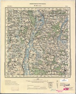
- Description:
- 1901
- Subject:
- Geographic Subject: Rokiškis, Topical Subject: Maps, and Topical Subject: Soviet Union
- Publisher:
- Генеральный штаб РККА
- Language:
- Russian
- Date Created:
- 1903
- Identifier:
- VAC9619-004007
- Genre:
- Topographic Maps and Military Maps
- Geographic Location:
- Coordinates: 55.667, 25.5, 56, 26
- Related URL:
- Catalog URL: https://iucat.iu.edu/catalog/5020129 and Download GeoTIFF: https://drive.google.com/file/d/1GKm3noUEDJyPwxN7ZxjiQnpDImQKGVui/view?usp=sharing
- Abstract:
- Modern area represented: Rokiškis, Panevėžys, Lithuania
- Call Number:
- G7000 s100 .S7 sheet N-35-4
- City:
- Рокишкис (Rokiškis)
- Copyright Holder:
- No Copyright - United States
- Country:
- Литва (Lithuania) and Латвия (Latvia)
- Physical Description:
- Scale: 1:100,000
- Persistent URL:
- http://purl.dlib.indiana.edu/iudl/images/VAC9619/VAC9619-004007
- Provenance:
- Army Map Service Library, Library of Congress G & M Division
-
- Description:
- 1901
- Subject:
- Geographic Subject: Uniejów, Topical Subject: Maps, and Topical Subject: Soviet Union
- Publisher:
- Управление военных топографов РККА
- Language:
- Russian
- Date Created:
- 1903
- Identifier:
- VAC9619-002721
- Genre:
- Military Maps and Topographic Maps
- Geographic Location:
- Coordinates: 51.667, 18.5, 52, 19
- Related URL:
- Catalog URL: https://iucat.iu.edu/catalog/5020129 and Download GeoTIFF: https://drive.google.com/file/d/1Z2XASPxOuBLm2jcy8DqA1qtSk23vmVjw/view?usp=sharing
- Abstract:
- Modern area represented: Uniejów, Łódź province, Poland
- Call Number:
- G7000 s100 .S7 sheet M-34-2
- City:
- Унейув (Uniejów)
- Copyright Holder:
- No Copyright - United States
- Country:
- Польша (Poland)
- Physical Description:
- Scale: 1:100,000
- Persistent URL:
- http://purl.dlib.indiana.edu/iudl/images/VAC9619/VAC9619-002721
- Provenance:
- CIA Map Library
-
- Description:
- 1900
- Subject:
- Topical Subject: Soviet Union, Topical Subject: Maps, and Geographic Subject: Martna
- Publisher:
- Генеральный штаб РККА
- Language:
- Russian
- Date Created:
- 1903
- Identifier:
- VAC9619-001689
- Genre:
- Military Maps and Topographic Maps
- Geographic Location:
- Coordinates: 58.83333, 23.75, 59.0, 24.0
- Related URL:
- Download GeoTIFF: https://drive.google.com/open?id=1gltLX5vdbfNTojOK5iomGmL9Oaks74N0 and Catalog URL: http://iucat.iu.edu/catalog/5020131
- Abstract:
- Modern area represented: Martna, Lääne county, Estonia
- Call Number:
- G7000 s50 .S68 sheet O-34-48-Б
- City:
- Мартна (Martna)
- Copyright Holder:
- No Copyright - United States
- Country:
- Эстония (Estonia)
- Physical Description:
- Scale: 1:50,000
- Persistent URL:
- http://purl.dlib.indiana.edu/iudl/images/VAC9619/VAC9619-001689
- Provenance:
- DMA Topographic Center, Army Map Service Library, OMAHA, Library of Congress Geography & Map Division
-
- Description:
- 1900
- Subject:
- Geographic Subject: Haapsalu, Topical Subject: Soviet Union, and Topical Subject: Maps
- Publisher:
- Генеральный штаб РККА
- Language:
- Russian
- Date Created:
- 1903
- Identifier:
- VAC9619-001687
- Genre:
- Military Maps and Topographic Maps
- Geographic Location:
- Coordinates: 58.833, 23.5, 59, 23.75
- Related URL:
- Catalog URL: http://iucat.iu.edu/catalog/5020131 and Download GeoTIFF: https://drive.google.com/open?id=1wwUJr80MJOSKOJQj4IGMLriXxfgJN9qn
- Abstract:
- Modern area represented: Haapsalu, Lääne county, Estonia
- Call Number:
- G7000 s50 .S68 sheet O-34-48-A
- City:
- Хапсалу (Haapsalu)
- Copyright Holder:
- No Copyright - United States
- Country:
- Эстония (Estonia)
- Physical Description:
- Scale: 1:50,000
- Persistent URL:
- http://purl.dlib.indiana.edu/iudl/images/VAC9619/VAC9619-001687
- Provenance:
- DMA Topographic Center, Army Map Service Library, OMAHA, Library of Congress Geography & Map Division
-
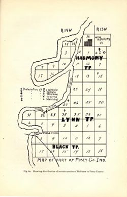
- Subject:
- Topical Subject: IGS Annual Reports, Geographic Subject: New Harmony (Ind.), and Geographic Subject: Posey County (Ind.)
- Publisher:
- Indiana. Department of Geology and Natural Resources
- Date Created:
- 1903
- Identifier:
- VAC3073-M-01576
- Genre:
- Thematic maps
- Related URL:
- Catalog URL: new.iucat.iu.edu/catalog/4022271
- Call Number:
- QE109 .A2 1902
- Caption:
- Imprint: Indianapolis : 1903.
- Physical Description:
- Scale: Scale not given.
- Persistent URL:
- https://purl.dlib.indiana.edu/iudl/images/VAC3073/VAC3073-M-01576
-
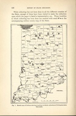
- Subject:
- Geographic Subject: Indiana, Topical Subject: IGS Annual Reports, and Topical Subject: Orthoptera--Collection and preservation
- Creator:
- Blatchley, W. S. (Willis Stanley), 1859-1940
- Publisher:
- Indiana. Department of Geology and Natural Resources
- Date Created:
- 1903
- Identifier:
- VAC3073-M-01574
- Genre:
- Thematic maps
- Geographic Location:
- Coordinates: W0880500 W0844700 N0414500 N0374600
- Related URL:
- Catalog URL: https://iucat.iu.edu/catalog/18418335
- Abstract:
- At head of title: "Fig. 1." Detached from: The Orthoptera of Indiana / by W. S. Blatchley. In Indiana Department of Geology and Natural Resource...
- Call Number:
- G4091.D4 1902 .B5
- Caption:
- Imprint: Indianapolis : Wm. B. Burford, [1903] and Imprint: [Indianapolis] : [Indiana Department of Geology and Natural Resouces], [1903]
- Physical Description:
- Scale: Approximately 1:2,850,000
- Alternate Identifier:
- Title Control Number: a18418335
- Persistent URL:
- https://purl.dlib.indiana.edu/iudl/images/VAC3073/VAC3073-M-01574
- Provenance:
- 27th Annual Report (1902) / Indiana. Department of Geology and Natural Resources.
-
![Indiana Haubstadt quadrangle [1935 reprint]](https://iiif.uits.iu.edu/iiif/2/1544cr71r%2Ffiles%2F5aabf650-fa83-48d4-bdcd-7579f3c6501a/full/250,/0/default.jpg)
- Subject:
- Geographic Subject: Posey County (Ind.), Geographic Subject: Gibson County (Ind.), and Geographic Subject: Vanderburgh County (Ind.)
- Creator:
- Geological Survey (U.S.)
- Publisher:
- Geological Survey (U.S.)
- Date Created:
- 1903
- Identifier:
- VAC3073-M-01505
- Genre:
- 15 minute topographic maps, Topographic maps, and Quadrangle maps
- Geographic Location:
- Coordinates: W0874500 W0873000 N0381500 N0380000
- Related URL:
- Catalog URL: https://iucat.iu.edu/catalog/18408287
- Abstract:
- Engraved Mar. 1903 by U.S.G.S. , Jno. H. Renshawe, geographer in charge , control by Geo. T. Hawkins , topography by Chas. W. Goodlove. Relief shown by conto...
- Call Number:
- G4090 s62 .G4 Haubstadt 1903 R1935
- Caption:
- Imprint: [Washington, D.C.] : U.S. Geological Survey, 1935
- Physical Description:
- Dimensions: 45 x 42 cm or smaller and Scale: 1:62,500
- Alternate Identifier:
- Title Control Number: a18408287
- Persistent URL:
- https://purl.dlib.indiana.edu/iudl/images/VAC3073/VAC3073-M-01505
- Provenance:
- Part of Geological Survey (U.S.). Indiana 1:62,500.

- « Previous
- Next »
- 1
- 2
- 3
- 4