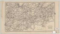
Topical Subject: Administrative and political divisions and Geographic Subject: Indiana
Creator:
Spears, Ed and Cram, George Franklin, 1841-1928
Publisher:
Western Map Depot
Date Created:
1875
Identifier:
VAC3073-M-01279
Genre:
Maps
Geographic Location:
Coordinates: W0880700 W0844500 N0414500 N0375200
Related URL:
Catalog URL: https://iucat.iu.edu/catalog/2801811
Abstract:
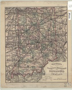
Variant title: New sectional map of Indiana Shows counties, townships, sections, cities and towns, and railroads. Includes text and census by counties. ...
Call Number:
G4090 1875 .C73
Caption:
Imprint: Chicago : Western Map Depot, 1875.
Physical Description:
Scale: Approximately 1:462,000 and Dimensions: 96 x 71 cm, on sheet 107 x 87 cm
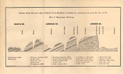
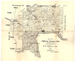
Prepared for the sixth annual report of E[.]T. Cox, State Geologist, 1874. Relief shown by hachures. Shows cities and towns, railroads, geology of the region...
Call Number:
G4093.J2C5 1874 .C6
Caption:
Imprint: [Indianapolis] : [Geological Survey of Indiana], [1875] and Imprint: [Indianapolis] : [Sentinel Co., printers], [1875]
Physical Description:
Scale: Approximately 1:130,000 and Dimensions: on sheet 40 x 47 cm
Alternate Identifier:
Title Control Number: a18318685 and Alternate ID: 390723IP
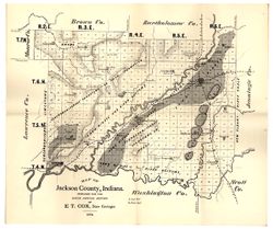
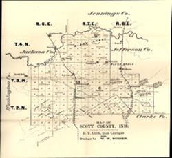
Prepared for the sixth annual report of E.T. Cox, State Geologist, geology by W.W. Borden. Relief shown by hachures. Shows cities and towns, railroads, and l...
Call Number:
G4093.J5C5 1874 .B6
Caption:
Imprint: [Indianapolis, Indiana] : [Sentinel Co., printers], [1875] and Imprint: [Indianapolis] : [Geological Survey of Indiana], [1875]
Physical Description:
Dimensions: 40 x 35 cm, on sheet 39 x 47 cm and Scale: Approximately 1:130,000
Alternate Identifier:
Alternate ID: 390723IP and Title Control Number: a18318691
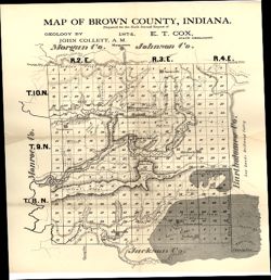
Topical Subject: IGS Annual Reports, Geographic Subject: Brown County (Ind.), Topical Subject: Geology, and Topical Subject: Mines and mineral resources
Prepared for the sixth annual report of E.T. Cox, State Geologist , geology by John Collett, 1874. Relief shown by hachures. Shows cities and towns, railroad...
Call Number:
G4093.B7C5 1874 .C6
Caption:
Imprint: [Indianapolis] : [Sentinel Company, printers], [1875] and Imprint: [Indianapolis] : [Geological Survey of Indiana], [1875]
Physical Description:
Scale: Approximately 1:120,000 and Dimensions: on sheet 39 x 35 cm
Alternate Identifier:
Alternate ID: 390723IP and Title Control Number: a18318678
Prepared for the sixth annual report of E.T. Cox, State Geologist / geology by W.W. Borden, 1874. Relief shown by hachures. Shows cities and towns, railroads...
Call Number:
G4093.S3G46 1874 .B6
Caption:
Imprint: [Indianapolis] : [Geological Survey of Indiana], [1875] and Imprint: [Indianapolis, Indiana] : [Sentinel Co., printers], [1875]
Physical Description:
Scale: Approximately 1:130,000 and Dimensions: 31 x 30 cm, on sheet 38 x 35 cm
Alternate Identifier:
Alternate ID: 390723IP and Title Control Number: a18318693
Topical Subject: Real property, Topical Subject: Landowners, and Geographic Subject: Clark County (Ind.)
Creator:
Davis, George W. (Civil Engineer)
Publisher:
Chas. A. McCann & David S. Koons
Date Created:
1875
Identifier:
VAC3073-M-00695
Genre:
Cadastral maps
Geographic Location:
Coordinates: W0860000 W0852500 N0383600 N0381600
Related URL:
Catalog URL: https://iucat.iu.edu/catalog/4685772
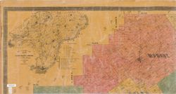
Abstract:
Cadastral map showing landowners. Originally printed in 3 sheets. Insets: Geological map of Clark County, Indiana -- Map of Indiana. Includes statistical tab...
Call Number:
G4093 .C4G46 1875 .D38
Caption:
Imprint: [Indianapolis] : Chas. A. McCann & David S. Koons, 1875
Physical Description:
Dimensions: 133 x 170 cm, pieces 48 x 89 cm and Scale: 1:31,680
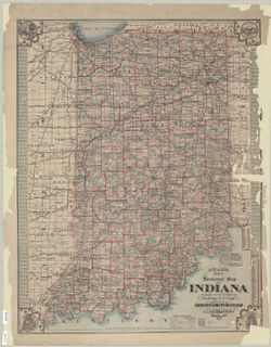
Prime meridians: Greenwich, Washington."Entered according to Act of Congress in the year 1875 by G. W. and C. B. Colton & Co in the Office of the Li...
Call Number:
G4901.P3 1875 .G8
Caption:
Imprint: [New York] : G. W. and C. B. Colton and Co., 1875.


![Cram's new sectional map of Indiana [map] / complied and published by George F. Cram , drawn & engraved in the offices of Geo. F. Cram by Ed Spears.](https://iiif.uits.iu.edu/iiif/2/9306v2729%2Ffiles%2Ff383089b-1489-467d-80c2-3f33e7384298/full/250,/0/default.jpg)