"This index is designed to inform map users of the various map series, special maps, and map byproducts produced and distributed by the U.S. Geological ...
Call Number:
G4091.A2 1992 .G4
Caption:
Imprint: Reston, Va. : The Survey and Imprint: Denver, Colo. : Map Distribution, [1992]
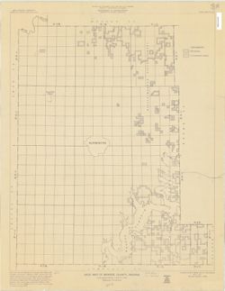
Blue line map. "May 1, 1951, revised January 1, 1968." Shows township and range numbers, section boundaries without numbers, State and National Fo...
Topical Subject: Aeronautical charts and Geographic Subject: Stout Field (Indianapolis, Ind.)
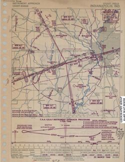
Creator:
U.S. Coast and Geodetic Survey
Publisher:
The Survey
Date Created:
1949
Identifier:
VAC3073-M-00040
Genre:
Aeronautical charts and Thematic maps
Geographic Location:
Coordinates: W0861458 W0861329 N0394433 N0394311 and W0861336 W0861326 N0394429 N0394419
Related URL:
Catalog URL: https://iucat.iu.edu/catalog/5325259
Abstract:
"Prepared under the direction of the Chief of Staff, U.S. Air Force for the Aeronautical Chart Service." "Base no. 1, March 1949." "...
Call Number:
G4094 .I4:2S8 1949 .U5
Caption:
Imprint: [Washington, D.C.] : The Survey, [1949]
Physical Description:
Scale: Approximately 1:226,000 and 1:31,680 and Dimensions: 18 x 18 cm, on sheet 27 x 21 cm