
Search Constraints
You searched for:
Publisher
Генеральный штаб Красной Армии
Remove constraint Publisher: Генеральный штаб Красной Армии
Search Results
-
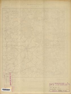
- Description:
- 1930
- Subject:
- Topical Subject: Maps, Geographic Subject: Zábřeh, and Topical Subject: Soviet Union
- Publisher:
- Генеральный штаб Красной Армии
- Language:
- Russian
- Date Created:
- 1940
- Identifier:
- VAC9619-002709
- Genre:
- Military Maps and Topographic Maps
- Geographic Location:
- Coordinates: 49.667, 16.5, 50, 17
- Related URL:
- Download GeoTIFF: https://drive.google.com/file/d/1CjzX8Dyvms5C72UF_C4UuUXEF5fI8WuI/view?usp=sharing and Catalog URL: https://iucat.iu.edu/catalog/5020129
- Abstract:
- Modern area represented: Zábřeh, Olomouc region, Czech Republic
- Call Number:
- G7000 s100 .S7 sheet M-33-82
- City:
- Хоенштадт (Hohenstadt)
- Copyright Holder:
- No Copyright - United States
- Country:
- Германия (Germany)
- State/Province:
- Протекторат Богемии и Моравии (Protectorate of Bohemia and Moravia)
- Physical Description:
- Scale: 1:100,000
- Persistent URL:
- http://purl.dlib.indiana.edu/iudl/images/VAC9619/VAC9619-002709
- Provenance:
- DMA Topographic Center, Library of Congress Geography & Map Division, Army Map Service Library, OMAHA
-
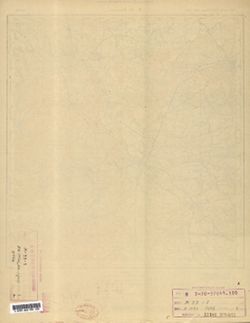
- Description:
- 1941
- Subject:
- Topical Subject: Soviet Union, Topical Subject: Maps, and Geographic Subject: Chrudim
- Publisher:
- Генеральный штаб Красной Армии
- Language:
- Russian
- Identifier:
- VAC9619-002707
- Genre:
- Military Maps and Topographic Maps
- Geographic Location:
- Coordinates: 49.667, 15.5, 50, 16
- Related URL:
- Catalog URL: https://iucat.iu.edu/catalog/5020129 and Download GeoTIFF: https://drive.google.com/file/d/1O0DJjm6JDfvtT2QlNV1ejYlQqOy4W6ga/view?usp=sharing
- Abstract:
- Modern area represented: Chrudim, Pardubice region, Czech Republic
- Call Number:
- G7000 s100 .S7 sheet M-33-80
- City:
- Хрудим (Chrudim)
- Copyright Holder:
- No Copyright - United States
- State/Province:
- Протекторат Богемии и Моравии (Protectorate of Bohemia and Moravia)
- Physical Description:
- Scale: 1:100,000
- Persistent URL:
- http://purl.dlib.indiana.edu/iudl/images/VAC9619/VAC9619-002707
- Provenance:
- DMA Topographic Center, Library of Congress Geography & Map Division, Army Map Service Library, OMAHA
-
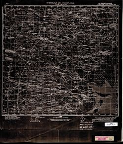
- Description:
- 1869
- Subject:
- Topical Subject: Soviet Union, Topical Subject: Maps, and Geographic Subject: Vysoké Mýto
- Publisher:
- Генеральный штаб Красной Армии
- Language:
- Russian
- Date Created:
- 1941
- Identifier:
- VAC9619-002708
- Genre:
- Military Maps and Topographic Maps
- Geographic Location:
- Coordinates: 49.667, 16, 50, 16.5
- Related URL:
- Download GeoTIFF: https://drive.google.com/file/d/1bxbg0QA-Bm4ku60mqvTMMgwr5Qr1bXw2/view?usp=sharing and Catalog URL: https://iucat.iu.edu/catalog/5020129
- Abstract:
- Modern area represented: Vysoké Mýto, Pardubice region, Czech Republic
- Call Number:
- G7000 s100 .S7 sheet M-33-81
- City:
- Високе Мито (Vysoké Mýto)
- Copyright Holder:
- No Copyright - United States
- Country:
- Германия (Germany)
- State/Province:
- Протекторат Богемии и Моравии (Protectorate of Bohemia and Moravia)
- Physical Description:
- Scale: 1:100,000
- Persistent URL:
- http://purl.dlib.indiana.edu/iudl/images/VAC9619/VAC9619-002708
- Provenance:
- DMA Topographic Center, Army Map Service Library, Library of Congress Geography & Map Division, Auswärtiges Amt. Geographischer Dienst, OMAHA
-
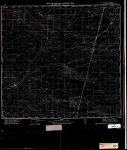
- Description:
- 1889
- Subject:
- Topical Subject: Maps, Topical Subject: Soviet Union, and Geographic Subject: Leszno
- Publisher:
- Генеральный штаб Красной Армии
- Language:
- Russian
- Date Created:
- 1940
- Identifier:
- VAC9619-002600
- Genre:
- Topographic Maps and Military Maps
- Geographic Location:
- Coordinates: 51.667, 16.5, 52, 17
- Related URL:
- Download GeoTIFF: https://drive.google.com/file/d/1qcz3KhHAqPFsX6CtdfiqqCVVuuFvfkOb/view?usp=sharing and Catalog URL: https://iucat.iu.edu/catalog/5020129
- Abstract:
- Modern area represented: Leszno, Greater Poland province, Poland
- Call Number:
- G7000 s100 .S7 sheet M-33-10
- City:
- Лисса (Lissa)
- Copyright Holder:
- No Copyright - United States
- Country:
- Германия (Germany)
- Physical Description:
- Scale: 1:100,000
- Persistent URL:
- http://purl.dlib.indiana.edu/iudl/images/VAC9619/VAC9619-002600
- Provenance:
- DMA Topographic Center, Library of Congress G & M Division, Army Map Service Library, OMAHA
-
- Description:
- 1890
- Subject:
- Topical Subject: Soviet Union, Topical Subject: Maps, and Geographic Subject: Wschowa
- Publisher:
- Генеральный штаб Красной Армии
- Language:
- Russian
- Date Created:
- 1940
- Identifier:
- VAC9619-002599
- Genre:
- Military Maps and Topographic Maps
- Geographic Location:
- Coordinates: 51.667, 16, 52, 16.5
- Related URL:
- Download GeoTIFF: https://drive.google.com/file/d/1qZMUTk_vq5rRTBPQ7ZCbxqo5jpUQ8Mxq/view?usp=sharing and Catalog URL: https://iucat.iu.edu/catalog/5020129
- Abstract:
- Modern area represented: Wschowa, Lubusz province, Poland
- Call Number:
- G7000 s100 .S7 sheet M-33-9
- City:
- Фрауштадт (Fraustadt)
- Copyright Holder:
- No Copyright - United States
- Country:
- Германия (Germany)
- Physical Description:
- Scale: 1:100,000
- Persistent URL:
- http://purl.dlib.indiana.edu/iudl/images/VAC9619/VAC9619-002599
- Provenance:
- DMA Topographic Center, Library of Congress G & M Division, Army Map Service Library, OMAHA
-
- Description:
- 1892
- Subject:
- Geographic Subject: Zielona Góra, Topical Subject: Maps, and Topical Subject: Soviet Union
- Publisher:
- Генеральный штаб Красной Армии
- Language:
- Russian
- Date Created:
- 1940
- Identifier:
- VAC9619-002598
- Genre:
- Topographic Maps and Military Maps
- Geographic Location:
- Coordinates: 51.667, 15.5, 52, 16
- Related URL:
- Catalog URL: https://iucat.iu.edu/catalog/5020129 and Download GeoTIFF: https://drive.google.com/file/d/1YDXCIuxj72uPvn2owXZ5x27Al5Zrrwzp/view?usp=sharing
- Abstract:
- Modern area represented: Zielona Góra, Lubusz province, Poland
- Call Number:
- G7000 s100 .S7 sheet M-33-8
- City:
- Грюнберг (Grünberg)
- Copyright Holder:
- No Copyright - United States
- Country:
- Германия (Germany)
- Physical Description:
- Scale: 1:100,000
- Persistent URL:
- http://purl.dlib.indiana.edu/iudl/images/VAC9619/VAC9619-002598
- Provenance:
- DMA Topographic Center, Library of Congress G & M Division, Army Map Service Library, OMAHA
-
- Description:
- 1940
- Subject:
- Topical Subject: Soviet Union, Topical Subject: Maps, and Geographic Subject: Lagan
- Publisher:
- Генеральный штаб Красной Армии
- Language:
- Russian
- Date Created:
- 1942
- Identifier:
- VAC9619-002597
- Genre:
- Military Maps and Topographic Maps
- Geographic Location:
- Coordinates: 45.333, 47, 45.667, 47.5
- Related URL:
- Catalog URL: https://iucat.iu.edu/catalog/5020129 and Download GeoTIFF: https://drive.google.com/file/d/118xqIxVJbCLMYzPknJMFF-ICTqV1twyN/view?usp=sharing
- Abstract:
- Modern area represented: Lagan, Kalmykiya Republic, Russia
- Call Number:
- G7000 s100 .S7 sheet L-38-95
- Caption:
- Для служебного пользования
- City:
- Лагань (Lagan)
- Copyright Holder:
- No Copyright - United States
- Country:
- СССР (USSR)
- State/Province:
- РСФСР (RSFSR), Сталинградская область (Stalingrad oblast), and Калмыцкая АССР (Kalmyk Autonomous Soviet Socialist Republic)
- Physical Description:
- Scale: 1:100,000
- Persistent URL:
- http://purl.dlib.indiana.edu/iudl/images/VAC9619/VAC9619-002597
- Provenance:
- CIA Map Library
-
- Description:
- 1941
- Subject:
- Topical Subject: Soviet Union, Geographic Subject: Naryn Khuduk, and Topical Subject: Maps
- Publisher:
- Генеральный штаб Красной Армии
- Language:
- Russian
- Date Created:
- 1942
- Identifier:
- VAC9619-002596
- Genre:
- Topographic Maps and Military Maps
- Geographic Location:
- Coordinates: 45.333, 46.5, 45.667, 47
- Related URL:
- Catalog URL: https://iucat.iu.edu/catalog/5020129 and Download GeoTIFF: https://drive.google.com/file/d/1V21zweeUxfPtxEE1eyaHMGOZBg7JZ5Ds/view?usp=sharing
- Abstract:
- Modern area represented: Naryn Khuduk, Kalmykiya Republic, Russia
- Call Number:
- G7000 s100 .S7 sheet L-38-94
- Caption:
- Для служебного пользования
- City:
- Нарын-Худук (Naryn-Khuduk)
- Copyright Holder:
- No Copyright - United States
- Country:
- СССР (USSR)
- State/Province:
- РСФСР (RSFSR) and Калмыцкая АССР (Kalmyk Autonomous Soviet Socialist Republic)
- Physical Description:
- Scale: 1:100,000
- Persistent URL:
- http://purl.dlib.indiana.edu/iudl/images/VAC9619/VAC9619-002596
- Provenance:
- CIA Map Library
-
- Description:
- 1939
- Subject:
- Topical Subject: Maps, Topical Subject: Soviet Union, and Geographic Subject: Vaganovo
- Publisher:
- Генеральный штаб Красной Армии
- Language:
- Russian
- Date Created:
- 1941
- Identifier:
- VAC9619-002562
- Genre:
- Military Maps and Topographic Maps
- Geographic Location:
- Coordinates: 60, 31, 60.333, 31.5
- Related URL:
- Download GeoTIFF: https://drive.google.com/file/d/1tHbGVqZHZdEJCGXk-kDTi5cgXC54uDTo/view?usp=sharing and Catalog URL: https://iucat.iu.edu/catalog/5020129
- Abstract:
- Modern area represented: Vaganovo, Leningrad oblast, Russia
- Call Number:
- G7000 s100 .S7 sheet P-36-135
- Caption:
- Для служебного пользования
- City:
- Ваганово (Vaganovo)
- Copyright Holder:
- No Copyright - United States
- Country:
- СССР (USSR)
- State/Province:
- Ленинградская область (Leningrad oblast) and РСФСР (RSFSR)
- Physical Description:
- Scale: 1:100,000
- Persistent URL:
- http://purl.dlib.indiana.edu/iudl/images/VAC9619/VAC9619-002562
- Provenance:
- DMA Topographic Center, Army Map Service Library, OMAHA
-
- Subject:
- Geographic Subject: Shuvalovo, Topical Subject: Soviet Union, and Topical Subject: Maps
- Publisher:
- Генеральный штаб Красной Армии
- Language:
- Russian
- Date Created:
- 1940
- Identifier:
- VAC9619-002561
- Genre:
- Military Maps and Topographic Maps
- Geographic Location:
- Coordinates: 60, 30, 60.333, 30.5
- Related URL:
- Download GeoTIFF: https://drive.google.com/file/d/1HSE6GiUOtSkJ7_BzusJuDugqPn8Ac_Xu/view?usp=sharing and Catalog URL: https://iucat.iu.edu/catalog/5020129
- Abstract:
- Currently a part of Saint Petersburg, Russia.
- Call Number:
- G7000 s100 .S7 sheet P-36-133
- Caption:
- Для служебного пользования
- City:
- Шувалово-Озерки (Shuvalovo-Ozerki)
- Copyright Holder:
- No Copyright - United States
- Country:
- СССР (USSR)
- State/Province:
- РСФСР (RSFSR) and Ленинградская область (Leningrad oblast)
- Physical Description:
- Scale: 1:100,000
- Persistent URL:
- http://purl.dlib.indiana.edu/iudl/images/VAC9619/VAC9619-002561
- Provenance:
- DMA Topographic Center, Army Map Service Library, OMAHA
