
Search Constraints
You searched for:
Country
СССР (USSR)
Remove constraint Country: СССР (USSR)
Date Created
1941
Remove constraint Date Created: 1941
« Previous |
1 - 10 of 792
|
Next »
Search Results
-
- Description:
- 1912
- Subject:
- Topical Subject: Maps, Topical Subject: Soviet Union, and Geographic Subject: Īvowghlī
- Publisher:
- Генеральный штаб Красной Армии
- Language:
- Russian
- Date Created:
- 1941
- Identifier:
- VAC9619-001041
- Genre:
- Military Maps and Topographic Maps
- Geographic Location:
- Coordinates: 38.6667, 45, 39, 45.5
- Related URL:
- Catalog URL: https://iucat.iu.edu/catalog/5020129 and Download GeoTIFF: https://drive.google.com/open?id=1qpvW4RsmwJh6m1WiJtJXW567d8q67ACe
- Abstract:
- Modern area represented: Īvowghlī, West Azerbaijan province, Iran
- Call Number:
- G7000 s100 .S7 sheet J-38-43
- Caption:
- Для служебного пользования
- City:
- Евоглю (Evoghlu)
- Copyright Holder:
- No Copyright - United States
- Country:
- СССР (USSR) and Иран (Iran)
- State/Province:
- Нахичеванская АССР (Nakhichevan Autonomous Soviet Socialist Republic)
- Physical Description:
- Scale: 1:100,000
- Persistent URL:
- http://purl.dlib.indiana.edu/iudl/images/VAC9619/VAC9619-001041
- Provenance:
- DMA Topographic Center, Army Map Service Library, Library of Congress Geography & Map Division, OMAHA
-
- Description:
- 1908
- Subject:
- Topical Subject: Soviet Union, Geographic Subject: Dzheguta, and Topical Subject: Maps
- Publisher:
- НКЗ СССР Сельхозаэросъемка
- Language:
- Russian
- Date Created:
- 1941
- Identifier:
- VAC9619-000718
- Genre:
- Topographic Maps and Military Maps
- Geographic Location:
- Coordinates: 43.6667, 42, 44, 42.5
- Related URL:
- Catalog URL: https://iucat.iu.edu/catalog/5020129 and Download GeoTIFF: https://drive.google.com/open?id=1kp0kGErywYJdw2pwrWDo3C-X9cu0C8Xk
- Abstract:
- Modern area represented: Dzheguta, Karachayevo-Cherkesiya Republic, Russia
- Call Number:
- G7000 s100 .S7 sheet K-38-1
- Caption:
- Временное издание,Для служебного пользования
- City:
- Джегутинский (Dzhegutinskiy)
- Copyright Holder:
- No Copyright - United States
- Country:
- СССР (USSR)
- State/Province:
- Орджоникидзевский край (Ordzhonikidze kray) and РСФСР (RSFSR)
- Physical Description:
- Scale: 1:100,000
- Persistent URL:
- http://purl.dlib.indiana.edu/iudl/images/VAC9619/VAC9619-000718
- Provenance:
- DMA Topographic Center, Army Map Service Library, OMAHA, Library of Congress Geography & Map Division
-
- Description:
- 1908
- Subject:
- Geographic Subject: Kislovodsk, Topical Subject: Soviet Union, and Topical Subject: Maps
- Publisher:
- НКЗ СССР Сельхозаэросъемка
- Language:
- Russian
- Date Created:
- 1941
- Identifier:
- VAC9619-000730
- Genre:
- Military Maps and Topographic Maps
- Geographic Location:
- Coordinates: 43.6667, 42.5, 44, 43
- Related URL:
- Catalog URL: https://iucat.iu.edu/catalog/5020129 and Download GeoTIFF: https://drive.google.com/open?id=1hE8Lj11I3DMGaxuNgdEk19cXKHishQi_
- Abstract:
- Modern area represented: Kislovodsk, Stavropol kray, Russia
- Call Number:
- G7000 s100 .S7 sheet K-38-2
- Caption:
- Для служебного пользования
- City:
- Кисловодск (Kislovodsk)
- Copyright Holder:
- No Copyright - United States
- Country:
- СССР (USSR)
- State/Province:
- Карачаевская автономная область (Karachay Autonomous Oblast), Орджоникидзевский край (Ordzhonikidze kray), РСФСР (RSFSR), and Кабардино-Балкарская АССР (Kaba...
- Physical Description:
- Scale: 1:100,000
- Persistent URL:
- http://purl.dlib.indiana.edu/iudl/images/VAC9619/VAC9619-000730
- Provenance:
- DMA Topographic Center, Atlasblatt, Army Map Service Library, Library of Congress Geography & Map Division, OMAHA
-
- Description:
- 1907
- Subject:
- Topical Subject: Soviet Union, Geographic Subject: Perekischkjul, and Topical Subject: Maps
- Publisher:
- Генеральный штаб Красной Армии
- Language:
- Russian
- Date Created:
- 1941
- Identifier:
- VAC9619-000892
- Genre:
- Military Maps and Topographic Maps
- Geographic Location:
- Coordinates: 40.3333, 49, 40.6667, 49.5
- Related URL:
- Download GeoTIFF: https://drive.google.com/open?id=1YAs8jfBXsWsytsvHAupvINf6BPXNHt5c and Catalog URL: https://iucat.iu.edu/catalog/5020129
- Abstract:
- Modern area represented: Perekischkjul, Abşeron district, Azerbaijan
- Call Number:
- G7000 s100 .S7 sheet K-39-123
- Caption:
- Для служебного пользования
- City:
- Перекишкюль (Perekischkjul)
- Copyright Holder:
- No Copyright - United States
- Country:
- СССР (USSR)
- State/Province:
- Азербайджанская ССР (Azerbaijan Soviet Socialist Republic)
- Physical Description:
- Scale: 1:100,000
- Persistent URL:
- http://purl.dlib.indiana.edu/iudl/images/VAC9619/VAC9619-000892
- Provenance:
- CIA Map Library, Library of Congress Geography & Map Division, Heeresplankammer Gruppe Archive Auslandskartenarchiv, Atlasblatt
-
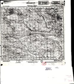
- Description:
- 1926
- Subject:
- Topical Subject: Maps, Geographic Subject: Tomakivka, and Topical Subject: Soviet Union
- Publisher:
- Генеральный штаб Красной Армии
- Language:
- Russian
- Date Created:
- 1941
- Identifier:
- VAC9619-001823
- Genre:
- Topographic Maps and Military Maps
- Geographic Location:
- Coordinates: 47.6667, 34.5, 48, 35
- Related URL:
- Download GeoTIFF: https://drive.google.com/file/d/14Nyu2PujbMSA_GYJjeQF3P2MPNH2zV-g/view?usp=sharing and Catalog URL: https://iucat.iu.edu/catalog/5020129
- Abstract:
- Modern area represented: Tomakivka, Dnipropetrovsk oblast, Ukraine
- Call Number:
- G7000 s100 .S7 sheet L-36-10
- Caption:
- Для служебного пользования
- City:
- Томаковка (Tomakivka)
- Copyright Holder:
- No Copyright - United States
- Country:
- СССР (USSR)
- State/Province:
- Запорожская область (Zaporizhia oblast) and Украинская ССР (Ukrainian Soviet Socialist Republic)
- Physical Description:
- Scale: 1:100,000
- Persistent URL:
- http://purl.dlib.indiana.edu/iudl/images/VAC9619/VAC9619-001823
- Provenance:
- CIA Map Library
-
- Description:
- 1895
- Subject:
- Topical Subject: Maps, Topical Subject: Soviet Union, Geographic Subject: Republic of Crimea, and Geographic Subject: Yevpatoriya
- Publisher:
- Генеральный штаб Красной Армии
- Language:
- Russian
- Date Created:
- 1941
- Identifier:
- VAC9619-001955
- Genre:
- Topographic Maps and Military Maps
- Geographic Location:
- Coordinates: 45, 33, 45.3333, 33.5
- Related URL:
- Download GeoTIFF: https://drive.google.com/open?id=1BtkwQn0L-XQPkON9n_c9ainj7EtEYvHh and Catalog URL: https://iucat.iu.edu/catalog/5020129
- Abstract:
- Modern area represented: Евпатория (Yevpatoriya), Republic of Crimea, Ukraine
- Call Number:
- G7000 s100 .S7 sheet L-36-103
- Caption:
- Для служебного пользования
- City:
- Евпатория (Yevpatoriya)
- Copyright Holder:
- No Copyright - United States
- Country:
- СССР (USSR)
- State/Province:
- РСФСР (RSFSR) and Крымская АССР (Crimean Autonomous Soviet Socialist Republic)
- Physical Description:
- Scale: 1:100,000
- Persistent URL:
- http://purl.dlib.indiana.edu/iudl/images/VAC9619/VAC9619-001955
- Provenance:
- DMA Topographic Center, OMAHA
-
- Description:
- 1895
- Subject:
- Geographic Subject: Republic of Crimea, Geographic Subject: Saki, Topical Subject: Soviet Union, and Topical Subject: Maps
- Publisher:
- Генеральный штаб Красной Армии
- Language:
- Russian
- Date Created:
- 1941
- Identifier:
- VAC9619-001956
- Genre:
- Topographic Maps and Military Maps
- Geographic Location:
- Coordinates: 45, 33.5, 45.3333, 34
- Related URL:
- Download GeoTIFF: https://drive.google.com/open?id=1KeZQMnq0svWW8sbbr2gRu_IXfdHE5Zod and Catalog URL: https://iucat.iu.edu/catalog/5020129
- Abstract:
- Modern area represented: Саки (Saki), Republic of Crimea, Ukraine
- Call Number:
- G7000 s100 .S7 sheet L-36-104
- Caption:
- Для cлужебного пользования
- City:
- Саки (Saki)
- Copyright Holder:
- No Copyright - United States
- Country:
- СССР (USSR)
- State/Province:
- РСФСР (RSFSR)
- Physical Description:
- Scale: 1:100,000
- Persistent URL:
- http://purl.dlib.indiana.edu/iudl/images/VAC9619/VAC9619-001956
- Provenance:
- CIA Map Library
-
- Description:
- 1894
- Subject:
- Topical Subject: Maps, Topical Subject: Soviet Union, Geographic Subject: Zuya, and Geographic Subject: Republic of Crimea
- Publisher:
- Генеральный штаб Красной Армии
- Language:
- Russian
- Date Created:
- 1941
- Identifier:
- VAC9619-001957
- Genre:
- Military Maps and Topographic Maps
- Geographic Location:
- Coordinates: 45, 34, 45.3333, 34.5
- Related URL:
- Catalog URL: https://iucat.iu.edu/catalog/5020129 and Download GeoTIFF: https://drive.google.com/open?id=1OnZgZa5AYScso5JZKHdHoMlUXdIKTLCN
- Abstract:
- Modern area represented: Зуя (Zuya), Republic of Crimea, Ukraine
- Call Number:
- G7000 s100 .S7 sheet L-36-105
- Caption:
- Для cлужебного пользования
- City:
- Зуя (Zuya)
- Copyright Holder:
- No Copyright - United States
- Country:
- СССР (USSR)
- State/Province:
- РСФСР (RSFSR) and Крымская АССР (Crimean Autonomous Soviet Socialist Republic)
- Physical Description:
- Scale: 1:100,000
- Persistent URL:
- http://purl.dlib.indiana.edu/iudl/images/VAC9619/VAC9619-001957
- Provenance:
- CIA Map Library
-
- Description:
- 1894
- Subject:
- Geographic Subject: Belogorsk, Geographic Subject: Republic of Crimea, Topical Subject: Soviet Union, and Topical Subject: Maps
- Publisher:
- Генеральный штаб Красной Армии
- Language:
- Russian
- Date Created:
- 1941
- Identifier:
- VAC9619-001958
- Genre:
- Topographic Maps and Military Maps
- Geographic Location:
- Coordinates: 45, 34.5, 45.3333, 35
- Related URL:
- Download GeoTIFF: https://drive.google.com/open?id=1nKMezCPbbFtDGWrByhCoLFbMRGzI6CvP and Catalog URL: https://iucat.iu.edu/catalog/5020129
- Abstract:
- Modern area represented: Карасубазар (Karasubazar), Republic of Crimea, Ukraine
- Call Number:
- G7000 s100 .S7 sheet L-36-106
- Caption:
- Для cлужебного пользования
- City:
- Карасубазар (Karasubazar)
- Copyright Holder:
- No Copyright - United States
- Country:
- СССР (USSR)
- State/Province:
- Крымская АССР (Crimean Autonomous Soviet Socialist Republic) and РСФСР (RSFSR)
- Physical Description:
- Scale: 1:100,000
- Persistent URL:
- http://purl.dlib.indiana.edu/iudl/images/VAC9619/VAC9619-001958
- Provenance:
- DMA Topographic Center
-
- Description:
- 1889
- Subject:
- Topical Subject: Maps, Geographic Subject: Republic of Crimea, Topical Subject: Soviet Union, and Geographic Subject: Feodosiya
- Publisher:
- Генеральный штаб Красной Армии
- Language:
- Russian
- Date Created:
- 1941
- Identifier:
- VAC9619-001959
- Genre:
- Military Maps and Topographic Maps
- Geographic Location:
- Coordinates: 45, 35, 45.3333, 35.5
- Related URL:
- Download GeoTIFF: https://drive.google.com/open?id=1zw4CQzIiaF0hYJlTRjCytykSghirEYb2 and Catalog URL: https://iucat.iu.edu/catalog/5020129
- Abstract:
- Modern area represented: Феодосия (Feodosiya), Republic of Crimea, Ukraine
- Call Number:
- G7000 s100 .S7 sheet L-36-107
- Caption:
- Для cлужебного пользования
- City:
- Феодосия (Feodosiya)
- Copyright Holder:
- No Copyright - United States
- Country:
- СССР (USSR)
- State/Province:
- РСФСР (RSFSR) and Крымская АССР (Crimean Autonomous Soviet Socialist Republic)
- Physical Description:
- Scale: 1:100,000
- Persistent URL:
- http://purl.dlib.indiana.edu/iudl/images/VAC9619/VAC9619-001959
- Provenance:
- DMA Topographic Center
