Jno. H. Renshawe, geographer in charge , control by Geo. T. Hawkins , topography by Chas. W. Goodlove. Filing title: Princeton, Ind.-Ill. Edition of 1903. Re...
Call Number:
G4090 s62 .G4 Princeton 1903 rep1918
Caption:
Imprint: Washington, D.C. : U.S. Geological Survey, 1918.
Physical Description:
Dimensions: 45 x 42 cm or smaller and Scale: 1:62,500
Geographic Subject: Darke County (Ohio), Geographic Subject: Randolph County (Ind.), and Geographic Subject: Wayne County (Ind.)
Creator:
Smith, Glenn S. (Glenn Shepard), Herron, W. H. (William Harrison), 1865-, Geological Survey (U.S.), Ohio. Division of Geological Survey, Harrison, R. L. (Top...
Publisher:
Geological Survey (U.S.)
Date Created:
1918
Identifier:
VAC3073-M-01310
Genre:
15 minute topographic maps, Quadrangle maps, and Topographic maps
W.H. Herron, acting chief geogrpher , Glenn S. Smith, topographic engineer in charge , topography by R.L. Harrison and W.L. Miller , control by J.R. Ellis, J...
Call Number:
G4090 s62 .G4 Winchester 1918
Caption:
Imprint: [Washington, D.C.] : U.S. Geological Survey, [1918]
Physical Description:
Scale: 1:62,500 and Dimensions: 45 x 42 cm or smaller
Jno. H. Renshawe, geographer in charge , control by Geo. T. Hawkins , topography by Chas. W. Goodlove. Filing title: Princeton, Ind.-Ill. Edition of 1903. Re...
Call Number:
G4090 s62 .G4 Princeton 1903 R1918
Caption:
Imprint: Washington, D.C. : U.S. Geological Survey, 1918
Physical Description:
Dimensions: 45 x 42 cm or smaller and Scale: 1:62,500
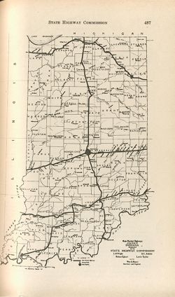
Appears in Report of State Highway Commission. In Year book of the state of Indiana for the year 1917. Indianapolis : Wm. B. Burford, contractor for state pr...
Call Number:
JK5631 .I6 1917
Caption:
Imprint: [Indianapolis] : [Wm. B. Burford, contractor for state printing and binding], [1918]
Physical Description:
Scale: Approximately 1:2,600,000 and Dimensions: on sheet 15 x 25 cm
Alternate Identifier:
Alternate ID: 397754IP and Title Control Number: a18422936

![Indiana-Illinois Princeton quadrangle [1918 reprint without vegetation]](https://iiif.uits.iu.edu/iiif/2/k356b654d%2Ffiles%2Fb7ecfd4f-f49f-4665-bea2-c519898beb43/full/250,/0/default.jpg)
![Indiana-Ohio, Winchester quadrangle [1918 printing]](https://iiif.uits.iu.edu/iiif/2/xw42pc314%2Ffiles%2F87f0e842-bedb-4ab3-a0e6-270a4e9f7c9a/full/250,/0/default.jpg)
![Indiana-Illinois Princeton quadrangle [1918 reprint without vegetation]](https://iiif.uits.iu.edu/iiif/2/4j03f204d%2Ffiles%2Ff6858e73-7524-45b9-95f0-84b35f918de9/full/250,/0/default.jpg)