
Search Constraints
You searched for:
Date Created
1937
Remove constraint Date Created: 1937
State/Province
РСФСР (RSFSR)
Remove constraint State/Province: РСФСР (RSFSR)
1 - 7 of 7
Search Results
-
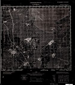
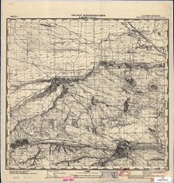
- Description:
- 1936
- Subject:
- Topical Subject: Soviet Union, Topical Subject: Maps, and Geographic Subject: Krasnapollye
- Publisher:
- Генеральный штаб РККА
- Language:
- Russian
- Date Created:
- 1937
- Identifier:
- VAC9619-004013
- Genre:
- Topographic Maps and Military Maps
- Geographic Location:
- Coordinates: 55.667, 29, 56, 29.5
- Related URL:
- DataCORE Dataset Download: https://datacore.iu.edu/concern/data_sets/zs25x938w
- Abstract:
- Modern area represented: Krasnapollye, Vitebsk oblast, Belarus
- Call Number:
- G7000 s100 .S7 sheet N-35-11
- Caption:
- Не подлежит оглашению
- City:
- Краснополье (Krasnapollye)
- Copyright Holder:
- No Copyright - United States
- Country:
- СССР (USSR)
- State/Province:
- Калининская область (Kalinin oblast), Витебская область (Vitebsk oblast), Белорусская ССР (Byelorussian Soviet Socialist Republic), and РСФСР (RSFSR)
- Physical Description:
- Scale: 1:100,000
- Persistent URL:
- http://purl.dlib.indiana.edu/iudl/images/VAC9619/VAC9619-004013
- Provenance:
- DMA Topographic Center, Army Map Service Library, OMAHA, Library of Congress Geography & Map Division
-
- Description:
- 1932
- Subject:
- Topical Subject: Maps, Geographic Subject: Voznesenka, and Topical Subject: Soviet Union
- Publisher:
- Генеральный штаб РККА
- Language:
- Russian
- Date Created:
- 1937
- Identifier:
- VAC9619-002583
- Genre:
- Topographic Maps and Military Maps
- Geographic Location:
- Coordinates: 44, 132, 44.333, 132.5
- Related URL:
- DataCORE Dataset Download: https://datacore.iu.edu/concern/data_sets/m900nv13r
- Abstract:
- Modern area represented: Voznesenka, Primorskiy kray, Russia
- Call Number:
- G7000 s100 .S7 sheet L-53-133
- Caption:
- Не подлежит оглашению
- City:
- Вознесенское (Voznesenskoye)
- Copyright Holder:
- No Copyright - United States
- Country:
- СССР (USSR)
- State/Province:
- РСФСР (RSFSR), Дальневосточный край (Far Eastern kray), and Уссурийская область (Ussuriysk oblast)
- Physical Description:
- Scale: 1:100,000
- Persistent URL:
- http://purl.dlib.indiana.edu/iudl/images/VAC9619/VAC9619-002583
- Provenance:
- Army Map Service Library
-
- Description:
- 1932
- Subject:
- Geographic Subject: Khorol, Topical Subject: Maps, and Topical Subject: Soviet Union
- Publisher:
- Генеральный штаб РККА
- Language:
- Russian
- Date Created:
- 1937
- Identifier:
- VAC9619-002580
- Genre:
- Military Maps and Topographic Maps
- Geographic Location:
- Coordinates: 44.333, 132, 44.667, 132.5
- Related URL:
- DataCORE Dataset Download: https://datacore.iu.edu/concern/data_sets/wm117p74h
- Abstract:
- Modern area represented: Khorol, Primorskiy kray, Russia
- Call Number:
- G7000 s100 .S7 sheet L-53-121
- Caption:
- Не подлежит оглашению
- City:
- Хороль (Khorol)
- Copyright Holder:
- No Copyright - United States
- Country:
- СССР (USSR)
- State/Province:
- Дальневосточный край (Far Eastern kray), РСФСР (RSFSR), and Уссурийская область (Ussuriysk oblast)
- Physical Description:
- Scale: 1:100,000
- Persistent URL:
- http://purl.dlib.indiana.edu/iudl/images/VAC9619/VAC9619-002580
- Provenance:
- Army Map Service Library
-
- Description:
- 1932
- Subject:
- Topical Subject: Soviet Union, Topical Subject: Maps, and Geographic Subject: Galenki
- Publisher:
- Генеральный штаб РККА
- Language:
- Russian
- Date Created:
- 1937
- Identifier:
- VAC9619-002544
- Genre:
- Topographic Maps and Military Maps
- Geographic Location:
- Coordinates: 44, 131.5, 44.333, 132
- Related URL:
- DataCORE Dataset Download: https://datacore.iu.edu/concern/data_sets/f4752h54w
- Abstract:
- Modern area represented: Galenki, Primorskiy kray, Russia
- Call Number:
- G7000 s100 .S7 sheet L-52-144
- Caption:
- Не подлежит оглашению
- City:
- Галенки (Galenki)
- Copyright Holder:
- No Copyright - United States
- Country:
- СССР (USSR)
- State/Province:
- РСФСР (RSFSR) and Уссурийская область (Ussuriysk oblast)
- Physical Description:
- Scale: 1:100,000
- Persistent URL:
- http://purl.dlib.indiana.edu/iudl/images/VAC9619/VAC9619-002544
- Provenance:
- DMA Topographic Center, Army Map Service Library
-
- Description:
- 1932
- Subject:
- Geographic Subject: Zharikovo, Topical Subject: Maps, and Topical Subject: Soviet Union
- Publisher:
- Генеральный штаб РККА
- Language:
- Russian
- Date Created:
- 1937
- Identifier:
- VAC9619-002543
- Genre:
- Topographic Maps and Military Maps
- Geographic Location:
- Coordinates: 44.333, 131.5, 44.667, 132
- Related URL:
- DataCORE Dataset Download: https://datacore.iu.edu/concern/data_sets/k643b1895
- Abstract:
- Modern area represented: Zharikovo, Primorsky kray, Russia
- Call Number:
- G7000 s100 .S7 sheet L-52-132
- Caption:
- Не подлежит оглашению
- City:
- Жариково (Zharikovo)
- Copyright Holder:
- No Copyright - United States
- Country:
- СССР (USSR)
- State/Province:
- Уссурийская область (Ussuriysk oblast), Приморский край (Primorsky kray), and РСФСР (RSFSR)
- Physical Description:
- Scale: 1:100,000
- Persistent URL:
- http://purl.dlib.indiana.edu/iudl/images/VAC9619/VAC9619-002543
- Provenance:
- DMA Topographic Center, Army Map Service Library
-
- Description:
- 1928
- Subject:
- Topical Subject: Maps, Topical Subject: Soviet Union, and Geographic Subject: Yessentuki
- Publisher:
- НКЗ СССР Сельхозаэросъемка
- Language:
- Russian
- Date Created:
- 1937
- Identifier:
- VAC9619-002219
- Genre:
- Topographic Maps and Military Maps
- Geographic Location:
- Coordinates: 44, 42.5, 44.3333, 43
- Related URL:
- DataCORE Dataset Download: https://datacore.iu.edu/concern/data_sets/kh04dq555
- Abstract:
- Modern area represented: Yessentuki, Stavropol kray, Russia
- Call Number:
- G7000 s100 .S7 sheet L-38-134
- Caption:
- Для служебного пользования
- City:
- Ессентуки (Yessentuki)
- Copyright Holder:
- No Copyright - United States
- Country:
- СССР (USSR)
- State/Province:
- РСФСР (RSFSR), Карачаевская автономная область (Karachay Autonomous Oblast), Орджоникидзевский край (Ordzhonikidze kray), and Черкесская автономная область (...
- Physical Description:
- Scale: 1:100,000
- Persistent URL:
- http://purl.dlib.indiana.edu/iudl/images/VAC9619/VAC9619-002219
- Provenance:
- CIA Map Library, Library of Congress Geography & Map Division
-
- Description:
- 1936
- Subject:
- Geographic Subject: Voloshovo, Topical Subject: Maps, and Topical Subject: Soviet Union
- Publisher:
- Генеральный штаб РККА
- Language:
- Russian
- Date Created:
- 1937
- Identifier:
- VAC9619-001852
- Genre:
- Topographic Maps and Military Maps
- Geographic Location:
- Coordinates: 58.667, 29.25, 58.833, 29.5
- Related URL:
- DataCORE Dataset Download: https://datacore.iu.edu/concern/data_sets/mp48sd58c
- Abstract:
- Modern area represented: Voloshovo, Russia
- Call Number:
- G7000 s50 .S68 sheet O-35-47-D
- Caption:
- Не подлежит оглашению
- City:
- Волошово (Voloshovo)
- Copyright Holder:
- No Copyright - United States
- Country:
- СССР (USSR)
- State/Province:
- РСФСР (RSFSR) and Ленинградская область (Leningrad oblast)
- Physical Description:
- Scale: 1:50,000
- Persistent URL:
- http://purl.dlib.indiana.edu/iudl/images/VAC9619/VAC9619-001852
- Provenance:
- Army Map Service Library, OMAHA, Library of Congress Geography & Map Division
