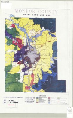
Topical Subject: Classification, Geographic Subject: Monroe County (Ind.), and Topical Subject: Soils
Creator:
United States. Bureau of Soils
Publisher:
United States. Bureau of Soils
Date Created:
1922
Identifier:
VAC3073-M-00651
Genre:
Thematic maps
Geographic Location:
Coordinates: W0880500 W0844700 N0414500 N0374600
Related URL:
Catalog URL: https://iucat.iu.edu/catalog/2872869
Abstract:
Coordinates: W 86°41ʹ--W 86°19ʹ / N 39°21ʹ--N 38°59ʹ. Relief shown by contours. Shows distribution of soil types by colors and sy...
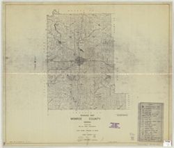
Geographic Subject: Salt Creek (Monroe County, Ind. : Township), Topical Subject: Soils, Geographic Subject: Monroe County (Ind.), and Topical Subject: Class...
Publisher:
[Indiana University, Dept. of Geography?]
Date Created:
1954
Identifier:
VAC3073-M-00647
Genre:
Thematic maps
Geographic Location:
Coordinates: W0862740 W0862203 N0390956 N0390442
Related URL:
Catalog URL: https://iucat.iu.edu/catalog/2872882
Abstract:
Title in manuscript on upper edge of map. Glossy photograph on photographic paper. Appears to be photographic enlargement made by James Edward Wrathall for h...
Call Number:
G4094 .S219J3 1954 .S65
Caption:
Imprint: [Bloomington, Ind.?] : [Indiana University, Dept. of Geography?], [1954?]
Physical Description:
Dimensions: 38 x 34 cm, on sheet 50 x 36 cm and Scale: 1:25,000
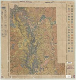
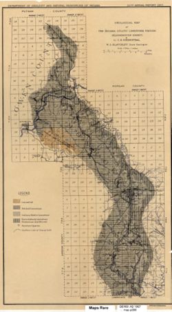
Topical Subject: Limestone, Geographic Subject: Owen County (Ind.), Geographic Subject: Bloomington Region (Ind.), Geographic Subject: Greene County (Ind.), ...
Creator:
Indiana. Department of Geology and Natural Resources
Publisher:
Indiana. Department of Geology and Natural Resources
Date Created:
1914
Identifier:
VAC3073-M-00351
Genre:
Topographic maps, Quadrangle maps, and Geological maps
Geographic Location:
Coordinates: W0864500 W0863000 N0391500 N0390000
Related URL:
Catalog URL: https://iucat.iu.edu/catalog/4896690
Abstract:
Relief shown by contours and spot heights. Contour interval 20 feet. Shows limestone locations in a portion of Monroe County and small portions of Owen and G...
Call Number:
G4093 .M7C5 1914 .I6
Caption:
Imprint: [Indianapolis] : Indiana Dept. of Geology [and Natural Resources], [1915] and Imprint: [Indianapolis] : [Wm. B. Burford], [1915]
Physical Description:
Dimensions: 45 x 35 cm and Scale: 1:62,500
Alternate Identifier:
Title Control Number: a4896690 and Alternate ID: 390726IP
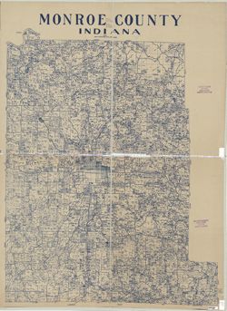
Geographic Subject: Monroe County (Ind.) and Topical Subject: Election districts
Publisher:
Herald-Telephone
Date Created:
1972
Identifier:
VAC3073-M-00291
Genre:
Thematic maps
Geographic Location:
Coordinates: W0864108 W0861902 N0392120 N0385926
Related URL:
Catalog URL: https://iucat.iu.edu/catalog/5300887
Abstract:
Shows election precincts for Monroe County, Ind., outside the City of Bloomington. Title supplied by cataloger. From Daily herald-telephone, Bloomingto...
Topical Subject: Limestone, Topical Subject: Geology, Geographic Subject: Owen County (Ind.), Geographic Subject: Monroe County (Ind.), and Topical Subject: ...
Creator:
Siebenthal, C. E. (Claude Ellsworth), 1869-1930
Publisher:
Indiana. Department of Geology and Natural Resources
Also shows location of lacustral, Mitchell limestone, and Harrodsburg limestone as well as those of abandoned quarries and the southern limit of glacial drif...
Call Number:
G4093.M7H5 1907 .S5
Caption:
Imprint: [Indianapolis] : [Indiana Dept. of Geology and Natural Resources], [1908]
Physical Description:
Scale: Approximately 1:126,720. 2 miles = 1 inches and Dimensions: 44 x 25 cm
Alternate Identifier:
Alternate ID: 390726IP and Title Control Number: a18307460
Geographic Subject: Monroe County (Ind.) and Topical Subject: Census districts
Creator:
United States. Bureau of the Census. Geography Division
Publisher:
United States. Bureau of the Census. Geography Division
Date Created:
1975
Identifier:
VAC3073-M-00254
Genre:
Census data and Thematic maps
Geographic Location:
Coordinates: W0864100 W0861900 N0392100 N0390000
Related URL:
Catalog URL: https://iucat.iu.edu/catalog/5304807
Abstract:
Title supplied by cataloger. Blue line print. Base map: General Highway and transportation map, Monroe County, Indiana / prepared by the Indiana State ...
Call Number:
G4093.M7 E25 1970 .U5
Caption:
Imprint: [Jeffersonville, Ind.] : [United States Bureau of the Census, Geography Division], [1970?]

![[Soil map, Salt Creek Township]](https://iiif.uits.iu.edu/iiif/2/df65w9840%2Ffiles%2Ffe188f45-0f9c-449f-a0a3-75953097395a/full/250,/0/default.jpg)
![Geology [Monroe County, Ind.]](https://iiif.uits.iu.edu/iiif/2/qv33t0191%2Ffiles%2F7a237c59-b869-4ad6-928c-c058aa8367af/full/250,/0/default.jpg)

![[Monroe County precinct map]](https://iiif.uits.iu.edu/iiif/2/2v23wx48n%2Ffiles%2F580e8721-dfe0-4842-9c08-d0ff81a6fc94/full/250,/0/default.jpg)
![[1970 census enumeration district and census tract map of Monroe County, Indiana]](https://iiif.uits.iu.edu/iiif/2/2f75sc93m%2Ffiles%2Fedd32def-9421-4508-92fa-fdb0f59fbb03/full/250,/0/default.jpg)