
Search Constraints
You searched for:
Date Created
1941
Remove constraint Date Created: 1941
Publisher
Генеральный штаб Красной Армии
Remove constraint Publisher: Генеральный штаб Красной Армии
« Previous |
1 - 10 of 782
|
Next »
Search Results
-
- Description:
- 1939
- Subject:
- Topical Subject: Soviet Union, Geographic Subject: Otradnoye, and Topical Subject: Maps
- Publisher:
- Генеральный штаб Красной Армии
- Language:
- Russian
- Date Created:
- 1941
- Identifier:
- VAC9619-000006
- Genre:
- Military Maps and Topographic Maps
- Geographic Location:
- Coordinates: 59.6667, 30.75, 59.8333, 31
- Related URL:
- Catalog URL: http://iucat.iu.edu/catalog/5020131 and Download GeoTIFF: https://drive.google.com/open?id=13COc5AgGZxXZZGDEvwCTHdGopCfnaIpJ
- Abstract:
- Modern area represented: Otradnoye, Russia
- Call Number:
- G7000 s50 .S68 sheet O-36-2-D
- Caption:
- Секретно
- City:
- Отрадное (Otradnoye)
- Copyright Holder:
- No Copyright - United States
- Country:
- СССР (USSR)
- State/Province:
- Ленинградская область (Leningrad oblast) and РСФСР (RSFSR)
- Physical Description:
- Scale: 1:50,000
- Persistent URL:
- http://purl.dlib.indiana.edu/iudl/images/VAC9619/VAC9619-000006
- Provenance:
- DMA Topographic Center, Army Map Service Library, OMAHA, Library of Congress Geography & Map Division
-
- Description:
- 1939
- Subject:
- Topical Subject: Maps, Geographic Subject: Kolpino, and Topical Subject: Soviet Union
- Publisher:
- Генеральный штаб Красной Армии
- Language:
- Russian
- Date Created:
- 1941
- Identifier:
- VAC9619-000005
- Genre:
- Topographic Maps and Military Maps
- Geographic Location:
- Coordinates: 59.6667, 30.5, 59.8333, 30.75
- Related URL:
- Download GeoTIFF: https://drive.google.com/open?id=1kGu3hZQppIl96eGP8w6F_llnnTJlbJhM and Catalog URL: http://iucat.iu.edu/catalog/5020131
- Abstract:
- Modern area represented: Kolpino, Russia
- Call Number:
- G7000 s50 .S68 sheet O-36-2-C
- Caption:
- Секретно,Captured map
- City:
- Колпино (Kolpino)
- Copyright Holder:
- No Copyright - United States
- Country:
- СССР (USSR)
- State/Province:
- РСФСР (RSFSR) and Ленинградская область (Leningrad oblast)
- Physical Description:
- Scale: 1:50,000
- Persistent URL:
- http://purl.dlib.indiana.edu/iudl/images/VAC9619/VAC9619-000005
- Provenance:
- Army Map Service Library, OMAHA, Library of Congress Geography & Map Division
-
- Description:
- 1939
- Subject:
- Topical Subject: Soviet Union, Topical Subject: Maps, and Geographic Subject: Pushkin
- Publisher:
- Генеральный штаб Красной Армии
- Language:
- Russian
- Date Created:
- 1941
- Identifier:
- VAC9619-000004
- Genre:
- Military Maps and Topographic Maps
- Geographic Location:
- Coordinates: 59.6667, 30.25, 59.8333, 30.5
- Related URL:
- Catalog URL: http://iucat.iu.edu/catalog/5020131 and Download GeoTIFF: https://drive.google.com/open?id=1xwf8d0kvCigjOtqFgrlqyY6TvkRzyFLT
- Abstract:
- Modern area represented: Pushkin, Russia
- Call Number:
- G7000 s50 .S68 sheet O-36-1-D
- Caption:
- Секретно
- City:
- Пушкин (Pushkin)
- Copyright Holder:
- No Copyright - United States
- Country:
- СССР (USSR)
- State/Province:
- РСФСР (RSFSR) and Ленинградская область (Leningrad oblast)
- Physical Description:
- Scale: 1:50,000
- Persistent URL:
- http://purl.dlib.indiana.edu/iudl/images/VAC9619/VAC9619-000004
- Provenance:
- Army Map Service Library, OMAHA, Library of Congress Geography & Map Division
-
- Description:
- 1939
- Subject:
- Topical Subject: Soviet Union, Geographic Subject: Krasnoye Selo, and Topical Subject: Maps
- Publisher:
- Генеральный штаб Красной Армии
- Language:
- Russian
- Date Created:
- 1941
- Identifier:
- VAC9619-000003
- Genre:
- Military Maps and Topographic Maps
- Geographic Location:
- Coordinates: 59.6667, 30, 59.8333, 30.25
- Related URL:
- Download GeoTIFF: https://drive.google.com/open?id=1GxWxJcbV7f4_Ezt52rTMQv35FunPPL9f and Catalog URL: http://iucat.iu.edu/catalog/5020131
- Abstract:
- Modern area represented: Krasnoye Selo, Russia
- Call Number:
- G7000 s50 .S68 sheet O-36-1-С
- Caption:
- Секретно
- City:
- Красное Село (Krasnoye Selo)
- Copyright Holder:
- No Copyright - United States
- Country:
- СССР (USSR)
- State/Province:
- Ленинградская область (Leningrad oblast) and РСФСР (RSFSR)
- Physical Description:
- Scale: 1:50,000
- Persistent URL:
- http://purl.dlib.indiana.edu/iudl/images/VAC9619/VAC9619-000003
- Provenance:
- DMA Topographic Center, Army Map Service Library, OMAHA, Library of Congress Geography & Map Division
-

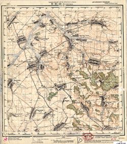
- Subject:
- Geographic Subject: Trostyanets, Topical Subject: Maps, and Topical Subject: Soviet Union
- Publisher:
- Генеральный штаб Красной Армии
- Language:
- Russian
- Date Created:
- 1941
- Identifier:
- VAC9619-000970
- Genre:
- Topographic Maps and Military Maps
- Geographic Location:
- Coordinates: 50.333333, 34.75, 50.5, 35.0
- Related URL:
- Catalog URL: http://iucat.iu.edu/catalog/5020131 and Download GeoTIFF: https://drive.google.com/open?id=1gc3NDRG7ImgHIVSQULYVrcANQDfApPkL
- Abstract:
- Modern area represented: Trostyanets, Sumy oblast, Ukraine
- Call Number:
- G7000 s50 .S68 sheet M-36-58-D
- Caption:
- Для служебного пользования
- City:
- Тростянец (Trostyanets)
- Copyright Holder:
- No Copyright - United States
- Country:
- СССР (USSR)
- State/Province:
- Украинская ССР (Ukrainian Soviet Socialist Republic) and Сумская область (Sumy oblast)
- Physical Description:
- Scale: 1:50,000
- Persistent URL:
- http://purl.dlib.indiana.edu/iudl/images/VAC9619/VAC9619-000970
- Provenance:
- DMA Topographic Center, Army Map Service Library, OMAHA, Library of Congress Geography & Map Division
-

- Description:
- 1938
- Subject:
- Topical Subject: Maps, Geographic Subject: Tovste, and Topical Subject: Soviet Union
- Publisher:
- Генеральный штаб Красной Армии
- Language:
- Russian
- Date Created:
- 1941
- Identifier:
- VAC9619-000956
- Genre:
- Topographic Maps and Military Maps
- Geographic Location:
- Coordinates: 50.83333, 34.0, 51.0, 34.25
- Related URL:
- Download GeoTIFF: https://drive.google.com/open?id=18NrtybSlEFYo6Cbg2zvy_2BEv4G6o9PT and Catalog URL: http://iucat.iu.edu/catalog/5020131
- Abstract:
- Modern area represented: Tovste, Sumy oblast, Ukraine
- Call Number:
- G7000 s50 .S68 sheet M-36-45-A
- Caption:
- Для служебного пользования
- City:
- Толстое (Tolstoe)
- Copyright Holder:
- No Copyright - United States
- Country:
- СССР (USSR)
- State/Province:
- Украинская ССР (Ukrainian Soviet Socialist Republic) and Сумская область (Sumy oblast)
- Physical Description:
- Scale: 1:50,000
- Persistent URL:
- http://purl.dlib.indiana.edu/iudl/images/VAC9619/VAC9619-000956
- Provenance:
- DMA Topographic Center, Army Map Service Library, OMAHA, Library of Congress Geography & Map Division
-
- Description:
- 1939
- Subject:
- Topical Subject: Soviet Union, Topical Subject: Maps, and Geographic Subject: Шерекино (Sherekino)
- Publisher:
- Генеральный штаб Красной Армии
- Language:
- Russian
- Date Created:
- 1941
- Identifier:
- VAC9619-000928
- Genre:
- Military Maps and Topographic Maps
- Geographic Location:
- Coordinates: 51.5, 35, 51.6667, 35.25
- Related URL:
- Download GeoTIFF: https://drive.google.com/open?id=1XH0YQW-4oSKl33cfPH4ETGiTYGet-1Pw and Catalog URL: http://iucat.iu.edu/catalog/5020131
- Abstract:
- Modern area represented: Шерекино (Sherekino), Kursk oblast, Russia
- Call Number:
- G7000 s50 .S68 sheet M-36-23-A
- Caption:
- Для служебного пользования
- City:
- Шерекино (Sherekino)
- Copyright Holder:
- No Copyright - United States
- Country:
- СССР (USSR)
- State/Province:
- РСФСР (RSFSR) and Курская область (Kursk oblast)
- Physical Description:
- Scale: 1:50,000
- Persistent URL:
- http://purl.dlib.indiana.edu/iudl/images/VAC9619/VAC9619-000928
- Provenance:
- DMA Topographic Center, Army Map Service Library, OMAHA, Library of Congress Geography & Map Division
-
- Description:
- 1939
- Subject:
- Topical Subject: Soviet Union, Topical Subject: Maps, and Geographic Subject: Зазірки (Zazirky)
- Publisher:
- Генеральный штаб Красной Армии
- Language:
- Russian
- Date Created:
- 1941
- Identifier:
- VAC9619-000924
- Genre:
- Military Maps and Topographic Maps
- Geographic Location:
- Coordinates: 51.3333, 33.5, 51.5, 33.75
- Related URL:
- Download GeoTIFF: https://drive.google.com/open?id=1VLeUNunQjzxHKvV63WpBJpDtbTIuUJ85 and Catalog URL: http://iucat.iu.edu/catalog/5020131
- Abstract:
- Modern area represented: Зазірки (Zazirky), Sumy Oblast, Ukraine
- Call Number:
- G7000 s50 .S68 sheet M-36-20-C
- Caption:
- Для служебного пользования
- City:
- Зазирки (Zazirki)
- Copyright Holder:
- No Copyright - United States
- Country:
- СССР (USSR)
- State/Province:
- Украинская ССР (Ukrainian Soviet Socialist Republic) and Сумская область (Sumy oblast)
- Physical Description:
- Scale: 1:50,000
- Persistent URL:
- http://purl.dlib.indiana.edu/iudl/images/VAC9619/VAC9619-000924
- Provenance:
- DMA Topographic Center, Army Map Service Library, Library of Congress Geography & Map Division
-
- Description:
- 1939
- Subject:
- Geographic Subject: Капыстичи (Kapystichi), Topical Subject: Soviet Union, and Topical Subject: Maps
- Publisher:
- Генеральный штаб Красной Армии
- Language:
- Russian
- Date Created:
- 1941
- Identifier:
- VAC9619-000908
- Genre:
- Topographic Maps and Military Maps
- Geographic Location:
- Coordinates: 51.6667, 34.75, 51.8333, 35
- Related URL:
- Download GeoTIFF: https://drive.google.com/open?id=1z7DDXNNUDp0rN1_wVnl0iVUfvnukBl4B and Catalog URL: http://iucat.iu.edu/catalog/5020131
- Abstract:
- Modern area represented: Капыстичи (Kapystichi), Kurskaya oblast, Russia
- Call Number:
- G7000 s50 .S68 sheet M-36-10-D
- Caption:
- Для служебного пользования
- City:
- Капустичи (Kapustichi)
- Copyright Holder:
- No Copyright - United States
- Country:
- СССР (USSR)
- State/Province:
- Курская область (Kursk oblast) and РСФСР (RSFSR)
- Physical Description:
- Scale: 1:50,000
- Persistent URL:
- http://purl.dlib.indiana.edu/iudl/images/VAC9619/VAC9619-000908
- Provenance:
- DMA Topographic Center, Army Map Service Library, OMAHA, Library of Congress Geography & Map Division
-
- Description:
- 1939
- Subject:
- Topical Subject: Soviet Union, Topical Subject: Maps, and Geographic Subject: Хомутовка (Khomutovka)
- Publisher:
- Генеральный штаб Красной Армии
- Language:
- Russian
- Date Created:
- 1941
- Identifier:
- VAC9619-000906
- Genre:
- Military Maps and Topographic Maps
- Geographic Location:
- Coordinates: 51.8333, 34.5, 52, 34.75
- Related URL:
- Catalog URL: http://iucat.iu.edu/catalog/5020131 and Download GeoTIFF: https://drive.google.com/open?id=1zRz69blepfjelo1KuRfCkbhDcWhmlfs-
- Abstract:
- Modern area represented: Хомутовка (Khomutovka), Kurskaya oblast, Russia
- Call Number:
- G7000 s50 .S68 sheet M-36-10-А
- Caption:
- Для служебного пользования
- City:
- Хомутовка (Khomutovka)
- Copyright Holder:
- No Copyright - United States
- Country:
- СССР (USSR)
- State/Province:
- РСФСР (RSFSR) and Курская область (Kursk oblast)
- Physical Description:
- Scale: 1:50,000
- Persistent URL:
- http://purl.dlib.indiana.edu/iudl/images/VAC9619/VAC9619-000906
- Provenance:
- Library of Congress Geography & Map Division
