
Search Constraints
You searched for:
Country
Литва (Lithuania)
Remove constraint Country: Литва (Lithuania)
Publisher
Управление военных топографов РККА
Remove constraint Publisher: Управление военных топографов РККА
« Previous |
1 - 10 of 13
|
Next »
Search Results
-
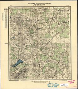
- Description:
- 1892
- Subject:
- Topical Subject: Maps, Topical Subject: Soviet Union, and Geographic Subject: Krakės
- Publisher:
- Управление военных топографов РККА
- Language:
- Russian
- Date Created:
- 1898
- Identifier:
- VAC9619-003904
- Genre:
- Topographic Maps and Military Maps
- Geographic Location:
- Coordinates: 55.333, 23.5, 55.667, 24
- Related URL:
- Catalog URL: https://iucat.iu.edu/catalog/5020129 and Download GeoTIFF: https://drive.google.com/file/d/1eP8FUfuMjxQiuhhZ5NVjCmhrcArwapQv/view?usp=sharing
- Abstract:
- Modern area represented: Krakės, Lithuania
- Call Number:
- G7000 s100 .S7 sheet N-34-24
- City:
- Кроки (Kroki)
- Copyright Holder:
- No Copyright - United States
- Country:
- Литва (Lithuania)
- Physical Description:
- Scale: 1:100,000
- Persistent URL:
- http://purl.dlib.indiana.edu/iudl/images/VAC9619/VAC9619-003904
- Provenance:
- DMA Topographic Center, Army Map Service Library, Auswärtiges Amt. Geographischer Dienst
-
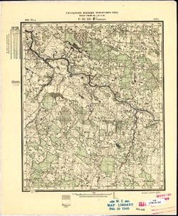
- Description:
- 1892
- Subject:
- Geographic Subject: Raseiniai, Topical Subject: Soviet Union, and Topical Subject: Maps
- Publisher:
- Управление военных топографов РККА
- Language:
- Russian
- Date Created:
- 1894
- Identifier:
- VAC9619-003903
- Genre:
- Topographic Maps and Military Maps
- Geographic Location:
- Coordinates: 55.333, 23, 55.667, 23.5
- Related URL:
- Catalog URL: https://iucat.iu.edu/catalog/5020129 and Download GeoTIFF: https://drive.google.com/file/d/1tmXQFHBkCfSkDM6lzkHUehMJPLaPBPTe/view?usp=sharing
- Abstract:
- Modern area represented: Raseiniai, Kaunas, Lithuania
- Call Number:
- G7000 s100 .S7 sheet N-34-23
- City:
- Россиены (Raseiniai)
- Copyright Holder:
- No Copyright - United States
- Country:
- Литва (Lithuania)
- Physical Description:
- Scale: 1:100,000
- Persistent URL:
- http://purl.dlib.indiana.edu/iudl/images/VAC9619/VAC9619-003903
- Provenance:
- DMA Topographic Center, Army Map Service Library
-
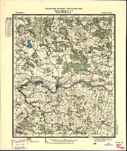
- Description:
- 1894
- Subject:
- Topical Subject: Maps, Topical Subject: Soviet Union, and Geographic Subject: Šilutė
- Publisher:
- Управление военных топографов РККА
- Language:
- Russian
- Date Created:
- 1912
- Identifier:
- VAC9619-003899
- Genre:
- Military Maps and Topographic Maps
- Geographic Location:
- Coordinates: 55.333, 21, 55.667, 21.5
- Related URL:
- Download GeoTIFF: https://drive.google.com/file/d/1IHHnxhC0ySuJTtWCJ48iYBtPYIwl60II/view?usp=sharing and Catalog URL: https://iucat.iu.edu/catalog/5020129
- Abstract:
- Modern area represented: Šilutė, Klaipėda County, Lithuania
- Call Number:
- G7000 s100 .S7 sheet N-34-19
- City:
- Шилутэ (Šilutė)
- Copyright Holder:
- No Copyright - United States
- Country:
- Литва (Lithuania)
- Physical Description:
- Scale: 1:100,000
- Persistent URL:
- http://purl.dlib.indiana.edu/iudl/images/VAC9619/VAC9619-003899
- Provenance:
- Army Map Service Library, Library of Congress G & M Division, Geographic Names Branch
-
- Description:
- 1894
- Subject:
- Topical Subject: Maps, Geographic Subject: Klaipėda, and Topical Subject: Soviet Union
- Publisher:
- Управление военных топографов РККА
- Language:
- Russian
- Date Created:
- 1910
- Identifier:
- VAC9619-003895
- Genre:
- Military Maps and Topographic Maps
- Geographic Location:
- Coordinates: 55.667, 21, 56, 21.5
- Related URL:
- Download GeoTIFF: https://drive.google.com/file/d/1Ww8-LLBsEzHcY-lFDTijchVNj8HHcVlj/view?usp=sharing and Catalog URL: https://iucat.iu.edu/catalog/5020129
- Abstract:
- Modern area represented: Klaipėda, Klaipėda county, Lithuania
- Call Number:
- G7000 s100 .S7 sheet N-34-7
- City:
- Клайпеда (Klaipėda)
- Copyright Holder:
- No Copyright - United States
- Country:
- Литва (Lithuania)
- Physical Description:
- Scale: 1:100,000
- Persistent URL:
- http://purl.dlib.indiana.edu/iudl/images/VAC9619/VAC9619-003895
- Provenance:
- DMA Topographic Center, Army Map Service Library
-
- Description:
- 1896
- Subject:
- Geographic Subject: Nevarėnai, Topical Subject: Soviet Union, and Topical Subject: Maps
- Publisher:
- Управление военных топографов РККА
- Language:
- Russian
- Identifier:
- VAC9619-001759
- Genre:
- Military Maps and Topographic Maps
- Geographic Location:
- Coordinates: 56, 22.25, 56.167, 22.5
- Related URL:
- Download GeoTIFF: https://drive.google.com/open?id=1HlaCUweDzvl7LcNiVqcDD5h3MEe86qsY and Catalog URL: http://iucat.iu.edu/catalog/5020131
- Abstract:
- Modern area represented: Nevarėnai, Telšiai district, Lithuania
- Call Number:
- G7000 s50 .S68 sheet O-34-141-D
- City:
- Невораны (Nevarėnai)
- Copyright Holder:
- No Copyright - United States
- Country:
- Литва (Lithuania)
- Physical Description:
- Scale: 1:50,000
- Persistent URL:
- http://purl.dlib.indiana.edu/iudl/images/VAC9619/VAC9619-001759
- Provenance:
- M. I. Map Library
-
- Description:
- 1896
- Subject:
- Topical Subject: Maps, Topical Subject: Soviet Union, and Geographic Subject: Lithuania
- Publisher:
- Управление военных топографов РККА
- Language:
- Russian
- Date Created:
- 1897
- Identifier:
- VAC9619-001757
- Genre:
- Military Maps and Topographic Maps
- Geographic Location:
- Coordinates: 56.167, 22.25, 56.333, 22.5
- Related URL:
- Catalog URL: http://iucat.iu.edu/catalog/5020131 and Download GeoTIFF: https://drive.google.com/open?id=1y0VI1KA5VHDdq8l92FpQsHS5r_DMT6sV
- Abstract:
- Modern area represented: Lithuania
- Call Number:
- G7000 s50 .S68 sheet O-34-141-Б
- City:
- Тыркшлэ (Tyrkshle)
- Copyright Holder:
- No Copyright - United States
- Country:
- Литва (Lithuania)
- Physical Description:
- Scale: 1:50,000
- Persistent URL:
- http://purl.dlib.indiana.edu/iudl/images/VAC9619/VAC9619-001757
- Provenance:
- M. I. Map Library, GS, RA
-
- Description:
- 1875
- Subject:
- Geographic Subject: Ezere, Topical Subject: Maps, and Topical Subject: Soviet Union
- Publisher:
- Управление военных топографов РККА
- Language:
- Russian
- Date Created:
- 1897
- Identifier:
- VAC9619-001739
- Genre:
- Topographic Maps and Military Maps
- Geographic Location:
- Coordinates: 56.333, 22.25, 56.5, 22.5
- Related URL:
- Download GeoTIFF: https://drive.google.com/open?id=1AO8npJGWadw_B5dNv1KXCXPz7ERhNbt6 and Catalog URL: http://iucat.iu.edu/catalog/5020131
- Abstract:
- Modern area represented: Ezere, Latvia
- Call Number:
- G7000 s50 .S68 sheet O-34-129-D
- City:
- Эзерэ (Ezere)
- Copyright Holder:
- No Copyright - United States
- Country:
- Литва (Lithuania) and Латвия (Latvia)
- Physical Description:
- Scale: 1:50,000
- Persistent URL:
- http://purl.dlib.indiana.edu/iudl/images/VAC9619/VAC9619-001739
- Provenance:
- CIA Map Branch -- Received
-

- Subject:
- Geographic Subject: Dūkštas, Topical Subject: Soviet Union, and Topical Subject: Maps
- Publisher:
- Управление военных топографов РККА
- Language:
- Russian
- Identifier:
- VAC9619-000449
- Genre:
- Military Maps and Topographic Maps
- Geographic Location:
- Coordinates: 55.5, 26.25, 55.6667, 26.5
- Related URL:
- Catalog URL: http://iucat.iu.edu/catalog/5020131 and Download GeoTIFF: https://drive.google.com/open?id=1yO04o0Z7DU5-WfSIYgjYTdjfPW8VRFce
- Abstract:
- Modern area represented: Dūkštas, Lithuania
- Call Number:
- G7000 s50 .S68 sheet N-35-17-B
- City:
- Дукшты (Dukshty)
- Copyright Holder:
- No Copyright - United States
- Country:
- Литва (Lithuania) and Польша (Poland)
- Physical Description:
- Scale: 1:50,000
- Persistent URL:
- http://purl.dlib.indiana.edu/iudl/images/VAC9619/VAC9619-000449
- Provenance:
- Army Map Service Library, OMAHA, Library of Congress Geography & Map Division
-

- Description:
- 1899
- Subject:
- Geographic Subject: Lėnas, Topical Subject: Maps, and Topical Subject: Soviet Union
- Publisher:
- Управление военных топографов РККА
- Language:
- Russian
- Date Created:
- 1931
- Identifier:
- VAC9619-000438
- Genre:
- Military Maps and Topographic Maps
- Geographic Location:
- Coordinates: 55.3333, 24.5, 55.5, 24.75
- Related URL:
- Catalog URL: http://iucat.iu.edu/catalog/5020131 and Download GeoTIFF: https://drive.google.com/open?id=11BV0OHjrniSQcx8fwYAJo-MUKrQZYsm2
- Abstract:
- Modern area represented: Lėnas, Lithuania
- Call Number:
- G7000 s50 .S68 sheet N-35-14-C
- City:
- Ланы (Lany)
- Copyright Holder:
- No Copyright - United States
- Country:
- Литва (Lithuania)
- Physical Description:
- Scale: 1:50,000
- Persistent URL:
- http://purl.dlib.indiana.edu/iudl/images/VAC9619/VAC9619-000438
- Provenance:
- Army Map Service Library, OMAHA, Library of Congress Geography & Map Division
-
- Description:
- 1900
- Subject:
- Topical Subject: Maps, Topical Subject: Soviet Union, and Geographic Subject: Anykščiai
- Publisher:
- Управление военных топографов РККА
- Language:
- Russian
- Identifier:
- VAC9619-000440
- Genre:
- Topographic Maps and Military Maps
- Geographic Location:
- Coordinates: 55.5, 25, 55.6667, 25.25
- Related URL:
- Catalog URL: http://iucat.iu.edu/catalog/5020131 and Download GeoTIFF: https://drive.google.com/open?id=1jX9R6R-SwuQB4FMpTEjfHdE-0G0CNs2m
- Abstract:
- Modern area represented: Anykščiai, Lithuania
- Call Number:
- G7000 s50 .S68 sheet N-35-15-A
- Caption:
- Captured map
- City:
- Оникшты (Onikshty)
- Copyright Holder:
- No Copyright - United States
- Country:
- Литва (Lithuania)
- Physical Description:
- Scale: 1:50,000
- Persistent URL:
- http://purl.dlib.indiana.edu/iudl/images/VAC9619/VAC9619-000440
- Provenance:
- DMA Topographic Center, Army Map Service Library, OMAHA, Library of Congress Geography & Map Division
