
Search Constraints
You searched for:
Publisher
Главное управление геодезии и картографии при СНК СССР
Remove constraint Publisher: Главное управление геодезии и картографии при СНК СССР
Search Results
-
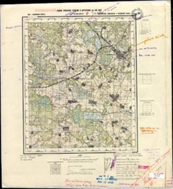
- Description:
- 1939
- Subject:
- Topical Subject: Soviet Union, Topical Subject: Maps, and Geographic Subject: Shuvayevo
- Publisher:
- Главное управление геодезии и картографии при СНК СССР
- Language:
- Russian
- Date Created:
- 1941
- Identifier:
- VAC9619-002891
- Genre:
- Topographic Maps and Military Maps
- Geographic Location:
- Coordinates: 56.833, 33, 57, 33.25
- Related URL:
- Download GeoTIFF: https://drive.google.com/file/d/13FWxkADRE7fKlwOO1oh0LeFe8xTQPSzX/view?usp=sharing and Catalog URL: http://iucat.iu.edu/catalog/5020131
- Abstract:
- Modern area represented: Шуваево (Shuvayevo), Tverskaya oblast, Russia
- Call Number:
- GM G7000 s50 .S68 sheet O-36-115-A
- Caption:
- Для служебного пользования
- City:
- Шуваево (Shuvayevo)
- Copyright Holder:
- No Copyright - United States
- Country:
- СССР (USSR)
- State/Province:
- Калининская область (Kalinin oblast) and РСФСР (RSFSR)
- Physical Description:
- Scale: 1:50,000
- Persistent URL:
- http://purl.dlib.indiana.edu/iudl/images/VAC9619/VAC9619-002891
- Provenance:
- DMA Topographic Center, Army Map Service Library, OMAHA, Library of Congress Geography & Map Division
-
- Description:
- 1939
- Subject:
- Topical Subject: Soviet Union, Topical Subject: Maps, and Geographic Subject: Okhvat
- Publisher:
- Главное управление геодезии и картографии при СНК СССР
- Language:
- Russian
- Identifier:
- VAC9619-002890
- Genre:
- Military Maps and Topographic Maps
- Geographic Location:
- Coordinates: 56.667, 32.25, 56.833, 32.5
- Related URL:
- Catalog URL: http://iucat.iu.edu/catalog/5020131 and Download GeoTIFF: https://drive.google.com/file/d/12gpJLt5cYQ-4EyKfpoFZBoYFcmuVjtDC/view?usp=sharing
- Abstract:
- Modern area represented: Охват (Okhvat), Tverskaya oblast, Russia
- Call Number:
- GM G7000 s50 .S68 sheet O-36-113-D
- Caption:
- Для служебного пользования and Captured map
- City:
- Охват (Okhvat)
- Copyright Holder:
- No Copyright - United States
- Country:
- СССР (USSR)
- State/Province:
- Пеновский район (Penovsky district), Калининская область (Kalinin oblast), and Ленинский район (Leninsky district)
- Physical Description:
- Scale: 1:50,000
- Persistent URL:
- http://purl.dlib.indiana.edu/iudl/images/VAC9619/VAC9619-002890
- Provenance:
- Army Map Service Library, OMAHA, Library of Congress Geography & Map Division
-
- Description:
- 1939
- Subject:
- Geographic Subject: Dudino, Topical Subject: Maps, and Topical Subject: Soviet Union
- Publisher:
- Главное управление геодезии и картографии при СНК СССР
- Language:
- Russian
- Identifier:
- VAC9619-002889
- Genre:
- Military Maps and Topographic Maps
- Geographic Location:
- Coordinates: 56.667, 32, 56.833, 32.25
- Related URL:
- Download GeoTIFF: https://drive.google.com/file/d/1Py3jDGm2QyjkNIWE8MgDv-5TtIaWklTa/view?usp=sharing and Catalog URL: http://iucat.iu.edu/catalog/5020131
- Abstract:
- Modern area represented: Дудино (Dudino), Tverskaya oblast, Russia
- Call Number:
- GM G7000 s50 .S68 sheet O-36-113-C
- Caption:
- Captured map and Для служебного пользования
- City:
- Дудино (Dudino)
- Copyright Holder:
- No Copyright - United States
- Country:
- СССР (USSR)
- State/Province:
- Калининская область (Kalinin oblast), Ленинский район (Leninsky district), and Пеновский район (Penovsky district)
- Physical Description:
- Scale: 1:50,000
- Persistent URL:
- http://purl.dlib.indiana.edu/iudl/images/VAC9619/VAC9619-002889
- Provenance:
- Army Map Service Library, OMAHA, Library of Congress Geography & Map Division
-
- Description:
- 1939
- Subject:
- Topical Subject: Maps, Topical Subject: Soviet Union, and Geographic Subject: Zabor’ye
- Publisher:
- Главное управление геодезии и картографии при СНК СССР
- Language:
- Russian
- Date Created:
- 1941
- Identifier:
- VAC9619-002888
- Genre:
- Topographic Maps and Military Maps
- Geographic Location:
- Coordinates: 56.833, 32.25, 57, 32.5
- Related URL:
- Catalog URL: http://iucat.iu.edu/catalog/5020131 and Download GeoTIFF: https://drive.google.com/file/d/1Bb2CzrK0F9Jaw1SPk85X2tY3L5pI2C0f/view?usp=sharing
- Abstract:
- Modern area represented: Заборье (Zabor’ye), Tverskaya oblast, Russia
- Call Number:
- GM G7000 s50 .S68 sheet O-36-113-B
- Caption:
- Captured map and Для служебного польлзования
- City:
- Заборье (Zabor’ye)
- Copyright Holder:
- No Copyright - United States
- Country:
- СССР (USSR)
- State/Province:
- Калининская область (Kalinin oblast), Пеновский район (Penovsky district), and Ленинский район (Leninsky district)
- Physical Description:
- Scale: 1:50,000
- Persistent URL:
- http://purl.dlib.indiana.edu/iudl/images/VAC9619/VAC9619-002888
- Provenance:
- Army Map Service Library, OMAHA, Library of Congress Geography & Map Division
-
- Description:
- 1939
- Subject:
- Topical Subject: Maps, Geographic Subject: Moskva, and Topical Subject: Soviet Union
- Publisher:
- Главное управление геодезии и картографии при СНК СССР
- Language:
- Russian
- Date Created:
- 1941
- Identifier:
- VAC9619-002887
- Genre:
- Military Maps and Topographic Maps
- Geographic Location:
- Coordinates: 56.833, 32, 57, 32.25
- Related URL:
- Download GeoTIFF: https://drive.google.com/file/d/1HXLiYhmYiLMFmGgV_fpSiNKzREzlQm5_/view?usp=sharing and Catalog URL: http://iucat.iu.edu/catalog/5020131
- Abstract:
- Modern area represented: Москва (Moskva), Tverskaya oblast, Russia
- Call Number:
- GM G7000 s50 .S68 sheet O-36-113-A
- Caption:
- Для служебного польлзования and Captured map
- City:
- Москва (Moskva)
- Copyright Holder:
- No Copyright - United States
- Country:
- СССР (USSR)
- State/Province:
- Сережинский район (Serezhinsky district), Калининская область (Kalinin oblast), Ленинский район (Leninsky district), and Пеновский район (Penovsky district)
- Physical Description:
- Scale: 1:50,000
- Persistent URL:
- http://purl.dlib.indiana.edu/iudl/images/VAC9619/VAC9619-002887
- Provenance:
- Army Map Service Library, OMAHA, Library of Congress Geography & Map Division
-
- Subject:
- Topical Subject: Soviet Union, Geographic Subject: Toropatsa, and Topical Subject: Maps
- Publisher:
- Главное управление геодезии и картографии при СНК СССР
- Language:
- Russian
- Date Created:
- 1941
- Identifier:
- VAC9619-002886
- Genre:
- Military Maps and Topographic Maps
- Geographic Location:
- Coordinates: 56.667, 31.75, 56.833, 32
- Related URL:
- Catalog URL: http://iucat.iu.edu/catalog/5020131 and Download GeoTIFF: https://drive.google.com/file/d/1TPtVfnB1w6YOtCGuXEgijtCftREUdIsl/view?usp=sharing
- Abstract:
- Modern area represented: Торопаца (Toropatsa), Tverskaya oblast, Russia
- Call Number:
- GM G7000 s50 .S68 sheet O-36-112-D
- City:
- Торопацы (Toropatsy)
- Copyright Holder:
- No Copyright - United States
- Country:
- СССР (USSR)
- State/Province:
- Сережинский район (Serezhinsky district), Ленинский район (Leninsky district), Калининская область (Kalinin oblast), and Торопецкий район (Toropetsky district)
- Physical Description:
- Scale: 1:50,000
- Persistent URL:
- http://purl.dlib.indiana.edu/iudl/images/VAC9619/VAC9619-002886
- Provenance:
- DMA Topographic Center, Army Map Service Library, OMAHA, Library of Congress Geography & Map Division
-
- Subject:
- Topical Subject: Soviet Union, Geographic Subject: Bologovo, and Topical Subject: Maps
- Publisher:
- Главное управление геодезии и картографии при СНК СССР
- Language:
- Russian
- Date Created:
- 1941
- Identifier:
- VAC9619-002885
- Genre:
- Topographic Maps and Military Maps
- Geographic Location:
- Coordinates: 56.833, 31.5, 57, 31.75
- Related URL:
- Catalog URL: http://iucat.iu.edu/catalog/5020131 and Download GeoTIFF: https://drive.google.com/file/d/1juqVJbGoU8Zx3SQ43V0pO0g0oCsviapa/view?usp=sharing
- Abstract:
- Modern area represented: Бологово (Bologovo), Tverskaya oblast, Russia
- Call Number:
- GM G7000 s50 .S68 sheet O-36-112-A
- Caption:
- Для служебного пользования
- City:
- Сережино (Serezhino)
- Copyright Holder:
- No Copyright - United States
- Country:
- СССР (USSR)
- State/Province:
- Сережинский район (Serezhinsky district) and Калининская область (Kalinin oblast)
- Physical Description:
- Scale: 1:50,000
- Persistent URL:
- http://purl.dlib.indiana.edu/iudl/images/VAC9619/VAC9619-002885
- Provenance:
- DMA Topographic Center, Army Map Service Library, OMAHA, Library of Congress Geography & Map Division
-
- Description:
- 1938
- Subject:
- Geographic Subject: Likhoslavl', Topical Subject: Soviet Union, and Topical Subject: Maps
- Publisher:
- Главное управление геодезии и картографии при СНК СССР
- Language:
- Russian
- Date Created:
- 1941
- Identifier:
- VAC9619-002852
- Genre:
- Military Maps and Topographic Maps
- Geographic Location:
- Coordinates: 57, 35.25, 57.167, 35.5
- Related URL:
- Download GeoTIFF: https://drive.google.com/file/d/1_1d7nZrOWqXaKo7w86AM92cd9KGEpK5Y/view?usp=sharing and Catalog URL: http://iucat.iu.edu/catalog/5020131
- Abstract:
- Modern area represented: Лихославль (Likhoslavl'), Тверская область (Tverskaya oblast), Russia
- Call Number:
- GM G7000 s50 .S68 sheet O-36-107-D
- City:
- Лихославль (Likhoslavl')
- Copyright Holder:
- No Copyright - United States
- Country:
- СССР (USSR)
- State/Province:
- Новоторжский район (Novotorzhsky district), Лихославльский район (Likhoslavlsky district), Калининская область (Kalinin oblast), and Медновский район (Mednov...
- Physical Description:
- Scale: 1:50,000
- Persistent URL:
- http://purl.dlib.indiana.edu/iudl/images/VAC9619/VAC9619-002852
- Provenance:
- M. I. Map Library
-
- Description:
- 1938
- Subject:
- Topical Subject: Soviet Union, Geographic Subject: Tereshkino, and Topical Subject: Maps
- Publisher:
- Главное управление геодезии и картографии при СНК СССР
- Language:
- Russian
- Date Created:
- 1941
- Identifier:
- VAC9619-002851
- Genre:
- Topographic Maps and Military Maps
- Geographic Location:
- Coordinates: 57, 35, 57.167, 35.25
- Related URL:
- Download GeoTIFF: https://drive.google.com/file/d/1ZxCCx26V9irbFiMxspZfiE2B2D0mKpmo/view?usp=sharing and Catalog URL: http://iucat.iu.edu/catalog/5020131
- Abstract:
- Modern area represented: Терешкино (Tereshkino), Тверская область (Tverskaya oblast), Russia
- Call Number:
- GM G7000 s50 .S68 sheet O-36-107-C
- Caption:
- Captured map
- City:
- Терешкино (Tereshkino)
- Copyright Holder:
- No Copyright - United States
- Country:
- СССР (USSR)
- State/Province:
- Калининская область (Kalinin oblast), Медновский район (Mednovsky district), Лихославльский район (Likhoslavlsky district), and Новоторжский район (Novotorzh...
- Physical Description:
- Scale: 1:50,000
- Persistent URL:
- http://purl.dlib.indiana.edu/iudl/images/VAC9619/VAC9619-002851
- Provenance:
- Army Map Service Library, OMAHA, Library of Congress Geography & Map Division
-
- Description:
- 1938
- Subject:
- Topical Subject: Soviet Union, Topical Subject: Maps, and Geographic Subject: Bol’shoye Ploskoye
- Publisher:
- Главное управление геодезии и картографии при СНК СССР
- Language:
- Russian
- Date Created:
- 1941
- Identifier:
- VAC9619-002850
- Genre:
- Topographic Maps and Military Maps
- Geographic Location:
- Coordinates: 57.167, 35.25, 57.333, 35.5
- Related URL:
- Catalog URL: http://iucat.iu.edu/catalog/5020131 and Download GeoTIFF: https://drive.google.com/file/d/1QbTVGhpTcwzq68sfhurfKNa6ZaCBc5b9/view?usp=sharing
- Abstract:
- Modern area represented: Большое Плоское (Bol’shoye Ploskoye), Тверская область (Tverskaya oblast), Russia
- Call Number:
- GM G7000 s50 .S68 sheet O-36-107-B
- Caption:
- Captured map
- City:
- Большое Плоское (Bol’shoye Ploskoye)
- Copyright Holder:
- No Copyright - United States
- Country:
- СССР (USSR)
- State/Province:
- Новоторжский район (Novotorzhsky district), Лихославльский район (Likhoslavlsky district), and Калининская область (Kalinin oblast)
- Physical Description:
- Scale: 1:50,000
- Persistent URL:
- http://purl.dlib.indiana.edu/iudl/images/VAC9619/VAC9619-002850
- Provenance:
- DMA Topographic Center, Army Map Service Library, OMAHA, Library of Congress Geography & Map Division
