
Search Constraints
Search Results
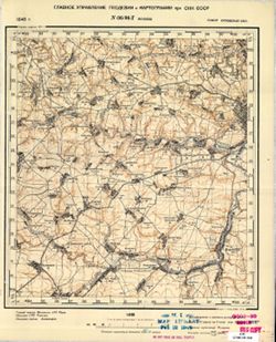
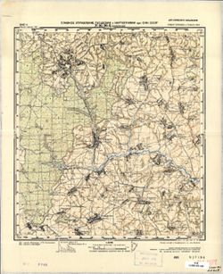
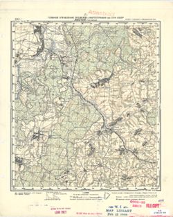
-

- Description:
- 1936
- Subject:
- Topical Subject: Maps, Topical Subject: Soviet Union, and Geographic Subject: Toshchitsa
- Publisher:
- Управление военных топографов РККА
- Language:
- Russian
- Identifier:
- VAC9619-001483
- Genre:
- Topographic Maps and Military Maps
- Geographic Location:
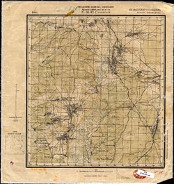
- Coordinates: 53.1667, 30, 53.3333, 30.25
- Related URL:
- Download GeoTIFF: https://drive.google.com/open?id=1_FYtD0RS3xN9iUCIS0n9c-h7tZVOzuti and Catalog URL: http://iucat.iu.edu/catalog/5020131
- Abstract:
- Modern area represented: Toshchitsa, Mogilev, Belarus
- Call Number:
- G7000 s50 .S68 sheet N-36-97-A
- Caption:
- Не подлежит оглашению
- City:
- Тощица (Toshchitsa)
- Copyright Holder:
- No Copyright - United States
- Country:
- СССР (USSR)
- State/Province:
- Белорусская ССР (Byelorussian Soviet Socialist Republic)
- Physical Description:
- Scale: 1:50,000
- Persistent URL:
- http://purl.dlib.indiana.edu/iudl/images/VAC9619/VAC9619-001483
- Provenance:
- Army Map Service Library, Library of Congress Geography & Map Division, OMAHA
-
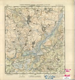
- Description:
- 1936
- Subject:
- Topical Subject: Soviet Union, Geographic Subject: Zvonets, and Topical Subject: Maps
- Publisher:
- Управление военных топографов РККА
- Language:
- Russian
- Identifier:
- VAC9619-001482
- Genre:
- Military Maps and Topographic Maps
- Geographic Location:
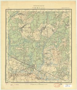
- Coordinates: 53.1667, 30.25, 53.3333, 30.5
- Related URL:
- Download GeoTIFF: https://drive.google.com/open?id=1r2DMZh2mjVq3AyPIe8qc-uOASC2UD_rt and Catalog URL: http://iucat.iu.edu/catalog/5020131
- Abstract:
- Modern area represented: Zvonets, Homyel oblast, Belarus
- Call Number:
- G7000 s50 .S68 sheet N-36-97-B
- Caption:
- Не подлежит оглашению
- City:
- Звонец (Zvonets)
- Copyright Holder:
- No Copyright - United States
- Country:
- СССР (USSR)
- State/Province:
- Белорусская ССР (Byelorussian Soviet Socialist Republic)
- Physical Description:
- Scale: 1:50,000
- Persistent URL:
- http://purl.dlib.indiana.edu/iudl/images/VAC9619/VAC9619-001482
- Provenance:
- DMA Topographic Center, Army Map Service Library, OMAHA, Library of Congress Geography & Map Division
-
- Description:
- 1938
- Subject:
- Topical Subject: Soviet Union, Geographic Subject: Rahachow, and Topical Subject: Maps
- Publisher:
- Управление военных топографов РККА
- Language:
- Russian
- Identifier:
- VAC9619-001480
- Genre:
- Military Maps and Topographic Maps
- Geographic Location:
- Coordinates: 53, 30, 53.1667, 30.25
- Related URL:
- Catalog URL: http://iucat.iu.edu/catalog/5020131 and Download GeoTIFF: https://drive.google.com/open?id=1MFbzEarSW1uw7S4tQoMKJtGj4hkW7fHv
- Abstract:
- Modern area represented: Rahachow, Homyel oblast, Belarus
- Call Number:
- G7000 s50 .S68 sheet N-36-97-C
- Caption:
- Не подлежит оглашению
- City:
- Рогачев (Rahachow)
- Copyright Holder:
- No Copyright - United States
- Country:
- СССР (USSR)
- State/Province:
- Белорусская ССР (Byelorussian Soviet Socialist Republic)
- Physical Description:
- Scale: 1:50,000
- Persistent URL:
- http://purl.dlib.indiana.edu/iudl/images/VAC9619/VAC9619-001480
- Provenance:
- Army Map Service Library, Library of Congress Geography & Map Division, OMAHA
-
- Description:
- 1940
- Subject:
- Topical Subject: Soviet Union, Geographic Subject: Bolkhov, and Topical Subject: Maps
- Publisher:
- Главное Управление Геодезии и Картографии при СНК СССР
- Language:
- Russian
- Date Created:
- 1941
- Identifier:
- VAC9619-001478
- Genre:
- Military Maps and Topographic Maps
- Geographic Location:
- Coordinates: 53.3333, 35.75, 53.5, 36
- Related URL:
- Catalog URL: http://iucat.iu.edu/catalog/5020131 and Download GeoTIFF: https://drive.google.com/open?id=14GGU-2tZQhcnZj2XMD6SOTLnhCnhaWpk
- Abstract:
- Modern area represented: Bolkhov, Oryol oblast, Russia
- Call Number:
- G7000 s50 .S68 sheet N-36-96-D
- City:
- Болхов (Bolkhov)
- Copyright Holder:
- No Copyright - United States
- Country:
- СССР (USSR)
- State/Province:
- РСФСР (RSFSR) and Орловская область (Oryol oblast)
- Physical Description:
- Scale: 1:50,000
- Persistent URL:
- http://purl.dlib.indiana.edu/iudl/images/VAC9619/VAC9619-001478
- Provenance:
- M. I. Map Library
-
- Description:
- 1940
- Subject:
- Topical Subject: Maps, Geographic Subject: Krasnikovo, and Topical Subject: Soviet Union
- Publisher:
- Главное Управление Геодезии и Картографии при СНК СССР
- Language:
- Russian
- Date Created:
- 1941
- Identifier:
- VAC9619-001475
- Genre:
- Topographic Maps and Military Maps
- Geographic Location:
- Coordinates: 53.3333, 35.5, 53.5, 35.75
- Related URL:
- Catalog URL: http://iucat.iu.edu/catalog/5020131 and Download GeoTIFF: https://drive.google.com/open?id=1DyEPReQM9x36qSIvp7gUcgZ7MeYkoKYY
- Abstract:
- Modern area represented: Krasnikovo, Oryol oblast, Russia
- Call Number:
- G7000 s50 .S68 sheet N-36-96-C
- City:
- Красниково (Krasnikovo)
- Copyright Holder:
- No Copyright - United States
- Country:
- СССР (USSR)
- State/Province:
- Орловская область (Oryol oblast) and РСФСР (RSFSR)
- Physical Description:
- Scale: 1:50,000
- Persistent URL:
- http://purl.dlib.indiana.edu/iudl/images/VAC9619/VAC9619-001475
- Provenance:
- Army Map Service Library, Library of Congress Geography & Map Division, OMAHA
-
- Description:
- 1940
- Subject:
- Topical Subject: Maps, Topical Subject: Soviet Union, and Geographic Subject: Kireykovo
- Publisher:
- Главное Управление Геодезии и Картографии при СНК СССР
- Language:
- Russian
- Date Created:
- 1941
- Identifier:
- VAC9619-001474
- Genre:
- Military Maps and Topographic Maps
- Geographic Location:
- Coordinates: 53.5, 35.75, 53.6667, 36
- Related URL:
- Download GeoTIFF: https://drive.google.com/open?id=1R9kpsNoGm2X6GcH_F6iUnZS863OTyOEz and Catalog URL: http://iucat.iu.edu/catalog/5020131
- Abstract:
- Modern area represented: Kireykovo, Kaluga, Russia
- Call Number:
- G7000 s50 .S68 sheet N-36-96-Б
- Caption:
- Для служебного пользования
- City:
- Кирейково (Kireykovo)
- Copyright Holder:
- No Copyright - United States
- Country:
- СССР (USSR)
- State/Province:
- Орловская область (Oryol oblast), РСФСР (RSFSR), and Тульская область (Tula oblast)
- Physical Description:
- Scale: 1:50,000
- Persistent URL:
- http://purl.dlib.indiana.edu/iudl/images/VAC9619/VAC9619-001474
- Provenance:
- CIA Map Branch -- Received
-
- Description:
- 1940
- Subject:
- Topical Subject: Soviet Union, Topical Subject: Maps, and Geographic Subject: Yelenskiy
- Publisher:
- Главное Управление Геодезии и Картографии при СНК СССР
- Language:
- Russian
- Date Created:
- 1941
- Identifier:
- VAC9619-001473
- Genre:
- Military Maps and Topographic Maps
- Geographic Location:
- Coordinates: 53.3333, 35.25, 53.5, 35.5
- Related URL:
- Download GeoTIFF: https://drive.google.com/open?id=1neOWFmBl0a_nccFqq5CAmb38-wHlEIlW and Catalog URL: http://iucat.iu.edu/catalog/5020131
- Abstract:
- Modern area represented: Yelenskiy, Kaluga, Russia
- Call Number:
- G7000 s50 .S68 sheet N-36-95-D
- City:
- Еленск (Yelensk)
- Copyright Holder:
- No Copyright - United States
- Country:
- СССР (USSR)
- State/Province:
- РСФСР (RSFSR) and Орловская область (Oryol oblast)
- Physical Description:
- Scale: 1:50,000
- Persistent URL:
- http://purl.dlib.indiana.edu/iudl/images/VAC9619/VAC9619-001473
- Provenance:
- Army Map Service Library, Library of Congress Geography & Map Division, OMAHA
-
- Description:
- 1939
- Subject:
- Topical Subject: Soviet Union, Topical Subject: Maps, and Geographic Subject: Khvastovichi
- Publisher:
- Главное Управление Геодезии и Картографии при СНК СССР
- Language:
- Russian
- Date Created:
- 1941
- Identifier:
- VAC9619-001471
- Genre:
- Topographic Maps and Military Maps
- Geographic Location:
- Coordinates: 53.3333, 35, 53.5, 35.25
- Related URL:
- Catalog URL: http://iucat.iu.edu/catalog/5020131 and Download GeoTIFF: https://drive.google.com/open?id=17H03IohW7ZiEY901MozN1DRbNUl-n2L5
- Abstract:
- Modern area represented: Khvastovichi, Kaluga, Russia
- Call Number:
- G7000 s50 .S68 sheet N-36-95-C
- City:
- Хвастовичи (Khvastovichi)
- Copyright Holder:
- No Copyright - United States
- Country:
- СССР (USSR)
- State/Province:
- РСФСР (RSFSR) and Орловская область (Oryol oblast)
- Physical Description:
- Scale: 1:50,000
- Persistent URL:
- http://purl.dlib.indiana.edu/iudl/images/VAC9619/VAC9619-001471
- Provenance:
- M. I. Map Library, Atlasblatt
-
- Description:
- 1940
- Subject:
- Geographic Subject: Vesniny, Topical Subject: Maps, and Topical Subject: Soviet Union
- Publisher:
- Главное Управление Геодезии и Картографии при СНК СССР
- Language:
- Russian
- Date Created:
- 1941
- Identifier:
- VAC9619-001470
- Genre:
- Military Maps and Topographic Maps
- Geographic Location:
- Coordinates: 53.5, 35.25, 53.6667, 35.5
- Related URL:
- Catalog URL: http://iucat.iu.edu/catalog/5020131 and Download GeoTIFF: https://drive.google.com/open?id=1h4jB7_zufkpu5_-Zl-G434kI4Z-2knW_
- Abstract:
- Modern area represented: Vesniny, Kaluga, Russia
- Call Number:
- G7000 s50 .S68 sheet N-36-95-B
- City:
- Веснины (Vesniny)
- Copyright Holder:
- No Copyright - United States
- Country:
- СССР (USSR)
- State/Province:
- Орловская область (Oryol oblast) and РСФСР (RSFSR)
- Physical Description:
- Scale: 1:50,000
- Persistent URL:
- http://purl.dlib.indiana.edu/iudl/images/VAC9619/VAC9619-001470
- Provenance:
- CIA Map Branch -- Received
-
- Description:
- 1940
- Subject:
- Topical Subject: Maps, Geographic Subject: Lovat, and Topical Subject: Soviet Union
- Publisher:
- Главное Управление Геодезии и Картографии при СНК СССР
- Language:
- Russian
- Date Created:
- 1941
- Identifier:
- VAC9619-001469
- Genre:
- Topographic Maps and Military Maps
- Geographic Location:
- Coordinates: 53.5, 35, 53.6667, 35.25
- Related URL:
- Catalog URL: http://iucat.iu.edu/catalog/5020131 and Download GeoTIFF: https://drive.google.com/open?id=1CW7q_WmzCjxXip6vtnCVNXn4ufl3e4Yl
- Abstract:
- Modern area represented: Lovat, Kaluga, Russia
- Call Number:
- G7000 s50 .S68 sheet N-36-95-A
- Caption:
- Для служебного пользования
- City:
- Ловать (Lovat)
- Copyright Holder:
- No Copyright - United States
- Country:
- СССР (USSR)
- State/Province:
- Орловская область (Oryol oblast), РСФСР (RSFSR), and Смоленская область (Smolensk oblast)
- Physical Description:
- Scale: 1:50,000
- Persistent URL:
- http://purl.dlib.indiana.edu/iudl/images/VAC9619/VAC9619-001469
- Provenance:
- DMA Topographic Center, Army Map Service Library, OMAHA, Library of Congress Geography & Map Division
-
- Description:
- 1930
- Subject:
- Geographic Subject: Boyanovichi, Topical Subject: Maps, and Topical Subject: Soviet Union
- Publisher:
- Генеральный штаб РККА
- Language:
- Russian
- Identifier:
- VAC9619-001468
- Genre:
- Military Maps and Topographic Maps
- Geographic Location:
- Coordinates: 53.3333, 34.75, 53.5, 35
- Related URL:
- Catalog URL: http://iucat.iu.edu/catalog/5020131 and Download GeoTIFF: https://drive.google.com/open?id=1DREx2N3APY6G30YlAAt889SzguoUBH-8
- Abstract:
- Modern area represented: Boyanovichi, Kaluga, Russia
- Call Number:
- G7000 s50 .S68 sheet N-36-94-D
- City:
- Буяновичи (Boyanovichi)
- Copyright Holder:
- No Copyright - United States
- Country:
- СССР (USSR)
- State/Province:
- РСФСР (RSFSR) and Западная область (Western oblast)
- Physical Description:
- Scale: 1:50,000
- Persistent URL:
- http://purl.dlib.indiana.edu/iudl/images/VAC9619/VAC9619-001468
- Provenance:
- DMA Topographic Center, Army Map Service Library, OMAHA, Library of Congress Geography & Map Division
-
- Description:
- 1930
- Subject:
- Geographic Subject: Ogor, Topical Subject: Soviet Union, and Topical Subject: Maps
- Publisher:
- Генеральный штаб РККА
- Language:
- Russian
- Identifier:
- VAC9619-001467
- Genre:
- Military Maps and Topographic Maps
- Geographic Location:
- Coordinates: 53.3333, 34.5, 53.5, 34.75
- Related URL:
- Download GeoTIFF: https://drive.google.com/open?id=1z8Szky-2BN4VYpKe91aBjVJdTlFW2w8J and Catalog URL: http://iucat.iu.edu/catalog/5020131
- Abstract:
- Modern area represented: Ogor, Kaluga, Russia
- Call Number:
- G7000 s50 .S68 sheet N-36-94-C
- City:
- Огорь (Ogor)
- Copyright Holder:
- No Copyright - United States
- Country:
- СССР (USSR)
- State/Province:
- РСФСР (RSFSR) and Западная область (Western oblast)
- Physical Description:
- Scale: 1:50,000
- Persistent URL:
- http://purl.dlib.indiana.edu/iudl/images/VAC9619/VAC9619-001467
- Provenance:
- DMA Topographic Center, Army Map Service Library, OMAHA, Library of Congress Geography & Map Division
-
- Description:
- 1930
- Subject:
- Geographic Subject: Podbuzhye, Topical Subject: Soviet Union, and Topical Subject: Maps
- Publisher:
- Управление военных топографов
- Language:
- Russian
- Identifier:
- VAC9619-001466
- Genre:
- Topographic Maps and Military Maps
- Geographic Location:
- Coordinates: 53.5, 34.75, 53.6667, 35
- Related URL:
- Catalog URL: http://iucat.iu.edu/catalog/5020131 and Download GeoTIFF: https://drive.google.com/open?id=1Eww5StjrX-Dqvf6ITLq-G9SIVbI7CZbV
- Abstract:
- Modern area represented: Podbuzhye, Kaluga, Russia
- Call Number:
- G7000 s50 .S68 sheet N-36-94-B
- Caption:
- Не подлежит оглашению
- City:
- Подбужье (Podbuzhye)
- Copyright Holder:
- No Copyright - United States
- Country:
- СССР (USSR)
- State/Province:
- РСФСР (RSFSR) and Западная область (Western oblast)
- Physical Description:
- Scale: 1:50,000
- Persistent URL:
- http://purl.dlib.indiana.edu/iudl/images/VAC9619/VAC9619-001466
- Provenance:
- Army Map Service Library, Library of Congress Geography & Map Division, OMAHA
-

- Description:
- 1930
- Subject:
- Geographic Subject: Uleml, Topical Subject: Maps, and Topical Subject: Soviet Union
- Publisher:
- Генеральный штаб Красной Армии
- Language:
- Russian
- Identifier:
- VAC9619-001465
- Genre:
- Topographic Maps and Military Maps
- Geographic Location:
- Coordinates: 53.5, 34.5, 53.6667, 34.75
- Related URL:
- Catalog URL: http://iucat.iu.edu/catalog/5020131 and Download GeoTIFF: https://drive.google.com/open?id=1U2PXzsrgKahBGHM3IuYx6EP5TM3z_EsH
- Abstract:
- Modern area represented: Uleml, Kaluga, Russia
- Call Number:
- G7000 s50 .S68 sheet N-36-94-A
- City:
- Улемль (Uleml)
- Copyright Holder:
- No Copyright - United States
- Country:
- СССР (USSR)
- State/Province:
- Западная область (Western oblast) and РСФСР (RSFSR)
- Physical Description:
- Scale: 1:50,000
- Persistent URL:
- http://purl.dlib.indiana.edu/iudl/images/VAC9619/VAC9619-001465
- Provenance:
- Army Map Service Library, Library of Congress Geography & Map Division, OMAHA
-
- Description:
- 1930
- Subject:
- Topical Subject: Maps, Topical Subject: Soviet Union, and Geographic Subject: Tsementniy
- Publisher:
- Управление военных топографов
- Language:
- Russian
- Identifier:
- VAC9619-001464
- Genre:
- Topographic Maps and Military Maps
- Geographic Location:
- Coordinates: 53.333333, 34.25, 53.5, 34.5
- Related URL:
- Catalog URL: http://iucat.iu.edu/catalog/5020131 and Download GeoTIFF: https://drive.google.com/open?id=1_hLet8LTbNamOAFJkTRu0yxEhS2JXJ71
- Abstract:
- Modern area represented: Tsementniy, Russia
- Call Number:
- G7000 s50 .S68 sheet N-36-93-D
- Caption:
- Не подлежит оглашению
- City:
- Цементный (Tsementniy)
- Copyright Holder:
- No Copyright - United States
- Country:
- СССР (USSR)
- State/Province:
- РСФСР (RSFSR) and Западная область (Western oblast)
- Physical Description:
- Scale: 1:50,000
- Persistent URL:
- http://purl.dlib.indiana.edu/iudl/images/VAC9619/VAC9619-001464
- Provenance:
- Library of Congress Geography & Map Division
-
- Description:
- 1930
- Subject:
- Geographic Subject: Dorozhovo, Topical Subject: Soviet Union, and Topical Subject: Maps
- Publisher:
- Генеральный штаб РККА
- Language:
- Russian
- Identifier:
- VAC9619-001462
- Genre:
- Topographic Maps and Military Maps
- Geographic Location:
- Coordinates: 53.333, 34, 53.5, 34.25
- Related URL:
- Catalog URL: http://iucat.iu.edu/catalog/5020131 and Download GeoTIFF: https://drive.google.com/file/d/1IoKkocKFWbu6Qc0u_yyNg9Xyt_t7bcRx/view?usp=sharing
- Abstract:
- Modern area represented: Dorozhovo, Bryansk oblast, Russia
- Call Number:
- G7000 s50 .S68 sheet N-36-93-В
- City:
- Дорожова (Dorozhova)
- Copyright Holder:
- No Copyright - United States
- Country:
- СССР (USSR)
- State/Province:
- РСФСР (RSFSR) and Западная область (Western oblast)
- Physical Description:
- Scale: 1:50,000
- Persistent URL:
- http://purl.dlib.indiana.edu/iudl/images/VAC9619/VAC9619-001462
- Provenance:
- Library of Congress Geography & Map Division
-
- Description:
- 1930
- Subject:
- Topical Subject: Soviet Union, Geographic Subject: Dyatkovo, and Topical Subject: Maps
- Publisher:
- Генеральный штаб Красной Армии
- Language:
- Russian
- Date Created:
- 1934
- Identifier:
- VAC9619-001459
- Genre:
- Military Maps and Topographic Maps
- Geographic Location:
- Coordinates: 53.5, 34.25, 53.6667, 34.5
- Related URL:
- Catalog URL: http://iucat.iu.edu/catalog/5020131 and Download GeoTIFF: https://drive.google.com/open?id=1wkEkkdNcz7GldyTFuISJ1O-cn2bTNxDO
- Abstract:
- Modern area represented: Dyatkovo, Bryansk oblast, Russia
- Call Number:
- G7000 s50 .S68 sheet N-36-93-B
- City:
- Дятьково (Dyatkovo)
- Copyright Holder:
- No Copyright - United States
- Country:
- СССР (USSR)
- State/Province:
- Орловская область (Oryol oblast) and РСФСР (RSFSR)
- Physical Description:
- Scale: 1:50,000
- Persistent URL:
- http://purl.dlib.indiana.edu/iudl/images/VAC9619/VAC9619-001459
- Provenance:
- Army Map Service Library, Library of Congress Geography & Map Division, OMAHA
-
- Description:
- 1930
- Subject:
- Geographic Subject: Dorozhovo, Topical Subject: Soviet Union, and Topical Subject: Maps
- Publisher:
- Генеральный штаб РККА
- Language:
- Russian
- Identifier:
- VAC9619-001458
- Genre:
- Topographic Maps and Military Maps
- Geographic Location:
- Coordinates: 53.3333, 34, 53.5, 34.25
- Related URL:
- Catalog URL: http://iucat.iu.edu/catalog/5020131 and Download GeoTIFF: https://drive.google.com/open?id=1BYCAZEWtRh1BqxrBTrB9jFx29DVLXjx5
- Abstract:
- Modern area represented: Dorozhovo, Bryansk oblast, Russia
- Call Number:
- G7000 s50 .S68 sheet N-36-93-C
- City:
- Дорожова (Dorozhovo)
- Copyright Holder:
- No Copyright - United States
- Country:
- СССР (USSR)
- State/Province:
- Западная область (Western oblast) and РСФСР (RSFSR)
- Physical Description:
- Scale: 1:50,000
- Persistent URL:
- http://purl.dlib.indiana.edu/iudl/images/VAC9619/VAC9619-001458
- Provenance:
- DMA Topographic Center, Army Map Service Library, OMAHA, Library of Congress Geography & Map Division
-
- Description:
- 1930
- Subject:
- Topical Subject: Maps, Topical Subject: Soviet Union, and Geographic Subject: Star
- Publisher:
- Генеральный штаб Красной Армии
- Language:
- Russian
- Identifier:
- VAC9619-001457
- Genre:
- Topographic Maps and Military Maps
- Geographic Location:
- Coordinates: 53.5, 34, 53.6667, 34.25
- Related URL:
- Catalog URL: http://iucat.iu.edu/catalog/5020131 and Download GeoTIFF: https://drive.google.com/open?id=1cwSkU0O5TqIj_1CEnBGyBnuygl-HrYzx
- Abstract:
- Modern area represented: Star, Russia
- Call Number:
- GM G7000 S50 .S68 N-36-93-A
- City:
- Старь (Star)
- Copyright Holder:
- No Copyright - United States
- Country:
- СССР (USSR)
- State/Province:
- РСФСР (RSFSR) and Западная область (Western oblast)
- Physical Description:
- Scale: 1:50,000
- Persistent URL:
- http://purl.dlib.indiana.edu/iudl/images/VAC9619/VAC9619-001457
- Provenance:
- Army Map Service Library, Library of Congress Geography & Map Division, OMAHA
-
- Description:
- 1930
- Subject:
- Topical Subject: Soviet Union, Geographic Subject: Ovstug, and Topical Subject: Maps
- Publisher:
- Генеральный штаб Красной Армии
- Language:
- Russian
- Date Created:
- 1934
- Identifier:
- VAC9619-001456
- Genre:
- Topographic Maps and Military Maps
- Geographic Location:
- Coordinates: 53.3333, 33.75, 53.5, 34
- Related URL:
- Download GeoTIFF: https://drive.google.com/open?id=1I6sKteDOcP8aB-wrlDx0H91c_nVlfZhD and Catalog URL: http://iucat.iu.edu/catalog/5020131
- Abstract:
- Modern area represented: Ovstug, Bryansk oblast, Russia
- Call Number:
- GM G7000 S50 .S68 N-36-92-Г
- City:
- Овстуг (Ovstug)
- Copyright Holder:
- No Copyright - United States
- Country:
- СССР (USSR)
- State/Province:
- РСФСР (RSFSR) and Орловская область (Oryol oblast)
- Physical Description:
- Scale: 1:50,000
- Persistent URL:
- http://purl.dlib.indiana.edu/iudl/images/VAC9619/VAC9619-001456
- Provenance:
- DMA Topographic Center, Army Map Service Library, Library of Congress Geography & Map Division
-
- Description:
- 1930
- Subject:
- Topical Subject: Soviet Union, Geographic Subject: Zhukovka, and Topical Subject: Maps
- Publisher:
- Генеральный штаб Красной Армии
- Language:
- Russian
- Date Created:
- 1934
- Identifier:
- VAC9619-001455
- Genre:
- Military Maps and Topographic Maps
- Geographic Location:
- Coordinates: 53.5, 33.5, 53.6667, 33.75
- Related URL:
- Download GeoTIFF: https://drive.google.com/open?id=1weURfFxzgvSsS3ue5gXFoe6joJn-NS4S and Catalog URL: http://iucat.iu.edu/catalog/5020131
- Abstract:
- Modern area represented: Zhukovka, Bryansk oblast, Russia
- Call Number:
- GM G7000 S50 .S68 N-36-92-A
- City:
- Жуковка (Zhukovka)
- Copyright Holder:
- No Copyright - United States
- Country:
- СССР (USSR)
- State/Province:
- Орловская область (Oryol oblast) and РСФСР (RSFSR)
- Physical Description:
- Scale: 1:50,000
- Persistent URL:
- http://purl.dlib.indiana.edu/iudl/images/VAC9619/VAC9619-001455
- Provenance:
- DMA Topographic Center, Army Map Service Library, OMAHA, Library of Congress Geography & Map Division
-
- Description:
- 1930
- Subject:
- Topical Subject: Soviet Union, Geographic Subject: Akulichi, and Topical Subject: Maps
- Publisher:
- Генеральный штаб Красной Армии
- Language:
- Russian
- Identifier:
- VAC9619-001454
- Genre:
- Military Maps and Topographic Maps
- Geographic Location:
- Coordinates: 53.3333, 33.25, 53.5, 33.5
- Related URL:
- Download GeoTIFF: https://drive.google.com/open?id=11jjoV3_-NKSU16yI4PsUEHocu5YYRnWC and Catalog URL: http://iucat.iu.edu/catalog/5020131
- Abstract:
- Modern area represented: Akulichi, Bryansk oblast, Russia
- Call Number:
- GM G7000 S50 .S68 N-36-91-Г
- City:
- Акуличи (Akulichi)
- Copyright Holder:
- No Copyright - United States
- Country:
- СССР (USSR)
- State/Province:
- Орловская область (Oryol oblast) and РСФСР (RSFSR)
- Physical Description:
- Scale: 1:50,000
- Persistent URL:
- http://purl.dlib.indiana.edu/iudl/images/VAC9619/VAC9619-001454
- Provenance:
- Army Map Service Library, Library of Congress Geography & Map Division, OMAHA
-
- Description:
- 1930
- Subject:
- Geographic Subject: Kletnya, Topical Subject: Soviet Union, and Topical Subject: Maps
- Publisher:
- Генеральный штаб Красной Армии
- Language:
- Russian
- Date Created:
- 1934
- Identifier:
- VAC9619-001453
- Genre:
- Topographic Maps and Military Maps
- Geographic Location:
- Coordinates: 53.3333, 33, 53.5, 33.25
- Related URL:
- Catalog URL: http://iucat.iu.edu/catalog/5020131 and Download GeoTIFF: https://drive.google.com/open?id=1oFXwGvIb9ojTDiTojklq9euajSXb2KgV
- Abstract:
- Modern area represented: Kletnya, Bryansk oblast, Russia
- Call Number:
- GM G7000 S50 .S68 N-36-91-В
- City:
- Клетня (Kletnya)
- Copyright Holder:
- No Copyright - United States
- Country:
- СССР (USSR)
- State/Province:
- Орловская область (Oryol oblast), РСФСР (RSFSR), and Смоленская область (Smolensk oblast)
- Physical Description:
- Scale: 1:50,000
- Persistent URL:
- http://purl.dlib.indiana.edu/iudl/images/VAC9619/VAC9619-001453
- Provenance:
- DMA Topographic Center, Army Map Service Library, Library of Congress Geography & Map Division
-
- Description:
- 1930
- Subject:
- Geographic Subject: Serpeyevka, Topical Subject: Soviet Union, and Topical Subject: Maps
- Publisher:
- Генеральный штаб РККА
- Language:
- Russian
- Identifier:
- VAC9619-001452
- Genre:
- Military Maps and Topographic Maps
- Geographic Location:
- Coordinates: 53.5, 33.25, 53.6667, 33.5
- Related URL:
- Download GeoTIFF: https://drive.google.com/open?id=1ejEYV2Cow1OTFQg5CTLMZeEAvh5FlLew and Catalog URL: http://iucat.iu.edu/catalog/5020131
- Abstract:
- Modern area represented: Serpeyevka, Bryansk oblast, Russia
- Call Number:
- GM G7000 S50 .S68 N-36-91-Б
- Caption:
- Не подлежит оглашению
- City:
- Серпеевка (Serpeyevka)
- Copyright Holder:
- No Copyright - United States
- Country:
- СССР (USSR)
- State/Province:
- РСФСР (RSFSR) and Орловская область (Oryol oblast)
- Physical Description:
- Scale: 1:50,000
- Persistent URL:
- http://purl.dlib.indiana.edu/iudl/images/VAC9619/VAC9619-001452
- Provenance:
- DMA Topographic Center, Army Map Service Library, OMAHA, Library of Congress Geography & Map Division
-
- Description:
- 1930
- Subject:
- Geographic Subject: Dengubovka, Topical Subject: Soviet Union, and Topical Subject: Maps
- Publisher:
- Генеральный штаб РККА
- Language:
- Russian
- Identifier:
- VAC9619-001451
- Genre:
- Topographic Maps and Military Maps
- Geographic Location:
- Coordinates: 53.5, 33, 53.6667, 33.25
- Related URL:
- Download GeoTIFF: https://drive.google.com/open?id=1KATAyPHstxiTa8so6QD3XBg2HvD6rN1U and Catalog URL: http://iucat.iu.edu/catalog/5020131
- Abstract:
- Modern area represented: Dengubovka, Bryansk oblast, Russia
- Call Number:
- GM G7000 S50 .S68 N-36-91-A
- City:
- Деньгубовка (Dengubovka)
- Copyright Holder:
- No Copyright - United States
- Country:
- СССР (USSR)
- State/Province:
- Орловская область (Oryol oblast), РСФСР (RSFSR), and Смоленская область (Smolensk oblast)
- Physical Description:
- Scale: 1:50,000
- Persistent URL:
- http://purl.dlib.indiana.edu/iudl/images/VAC9619/VAC9619-001451
- Provenance:
- DMA Topographic Center, Army Map Service Library, OMAHA, Library of Congress Geography & Map Division
-
- Description:
- 1931
- Subject:
- Geographic Subject: Razrytoye, Topical Subject: Maps, and Topical Subject: Soviet Union
- Publisher:
- Управление военных топографов
- Language:
- Russian
- Identifier:
- VAC9619-001450
- Genre:
- Topographic Maps and Military Maps
- Geographic Location:
- Coordinates: 53.3333, 32.75, 53.5, 33
- Related URL:
- Download GeoTIFF: https://drive.google.com/open?id=1Ks2FByvEOj90pyqtFjIQtDkk--6HbR4S and Catalog URL: http://iucat.iu.edu/catalog/5020131
- Abstract:
- Modern area represented: Razrytoye, Bryansk oblast, Russia
- Call Number:
- GM G7000 S50 .S68 N-36-90-Г
- Caption:
- Не подлежит оглашению
- City:
- Разрытое (Razrytoye)
- Copyright Holder:
- No Copyright - United States
- Country:
- СССР (USSR)
- State/Province:
- Западная область (Western oblast), Белорусская ССР (Byelorussian Soviet Socialist Republic), and РСФСР (RSFSR)
- Physical Description:
- Scale: 1:50,000
- Persistent URL:
- http://purl.dlib.indiana.edu/iudl/images/VAC9619/VAC9619-001450
- Provenance:
- DMA Topographic Center, Army Map Service Library, OMAHA, Library of Congress Geography & Map Division
-
- Description:
- 1931
- Subject:
- Topical Subject: Maps, Geographic Subject: Khotsimsk, and Topical Subject: Soviet Union
- Publisher:
- Управление военных топографов
- Language:
- Russian
- Identifier:
- VAC9619-001449
- Genre:
- Topographic Maps and Military Maps
- Geographic Location:
- Coordinates: 53.3333, 32.5, 53.5, 32.75
- Related URL:
- Catalog URL: http://iucat.iu.edu/catalog/5020131 and Download GeoTIFF: https://drive.google.com/open?id=1ZmiZjUqsnNBRU3BSCba3527a5Zbrphdb
- Abstract:
- Modern area represented: Khotsimsk, Mogilev oblast, Belarus
- Call Number:
- GM G7000 S50 .S68 N-36-90-В
- Caption:
- Не подлежит оглашению
- City:
- Хотимск (Khotsimsk)
- Copyright Holder:
- No Copyright - United States
- Country:
- СССР (USSR)
- State/Province:
- РСФСР (RSFSR), Западная область (Western oblast), and Белорусская ССР (Byelorussian Soviet Socialist Republic)
- Physical Description:
- Scale: 1:50,000
- Persistent URL:
- http://purl.dlib.indiana.edu/iudl/images/VAC9619/VAC9619-001449
- Provenance:
- Army Map Service Library, Library of Congress Geography & Map Division, OMAHA
-
- Description:
- 1931
- Subject:
- Topical Subject: Maps, Topical Subject: Soviet Union, and Geographic Subject: Yershichi
- Publisher:
- Генеральный штаб Красной Армии
- Language:
- Russian
- Identifier:
- VAC9619-001448
- Genre:
- Military Maps and Topographic Maps
- Geographic Location:
- Coordinates: 53.5, 32.75, 53.6667, 33
- Related URL:
- Download GeoTIFF: https://drive.google.com/open?id=1Bl-SNPTfZQkf98UUKHhVOsJI1_LOzEdh and Catalog URL: http://iucat.iu.edu/catalog/5020131
- Abstract:
- Modern area represented: Yershichi, Smolensk oblast, Russia
- Call Number:
- GM G7000 S50 .S68 N-36-90-Б
- Caption:
- Для служебного пользования
- City:
- Ершичи (Yershichi)
- Copyright Holder:
- No Copyright - United States
- Country:
- СССР (USSR)
- State/Province:
- Западная область (Western oblast) and РСФСР (RSFSR)
- Physical Description:
- Scale: 1:50,000
- Persistent URL:
- http://purl.dlib.indiana.edu/iudl/images/VAC9619/VAC9619-001448
- Provenance:
- DMA Topographic Center, Army Map Service Library, OMAHA, Library of Congress Geography & Map Division
-
- Description:
- 1931
- Subject:
- Topical Subject: Soviet Union, Topical Subject: Maps, and Geographic Subject: Kuzmichi
- Publisher:
- Управление военных топографов
- Language:
- Russian
- Identifier:
- VAC9619-001447
- Genre:
- Military Maps and Topographic Maps
- Geographic Location:
- Coordinates: 53.5, 32.5, 53.6667, 32.75
- Related URL:
- Catalog URL: http://iucat.iu.edu/catalog/5020131 and Download GeoTIFF: https://drive.google.com/open?id=1-XmXUvz-NWzYLI5vcfNZ0lrJwju8ZcyP
- Abstract:
- Modern area represented: Kuzmichi, Smolensk oblast, Russia
- Call Number:
- GM G7000 S50 .S68 N-36-90-A
- City:
- Кузьмичи (Kuzmichi)
- Copyright Holder:
- No Copyright - United States
- Country:
- СССР (USSR)
- State/Province:
- РСФСР (RSFSR), Белорусская ССР (Byelorussian Soviet Socialist Republic), and Западная область (Western oblast)
- Physical Description:
- Scale: 1:50,000
- Persistent URL:
- http://purl.dlib.indiana.edu/iudl/images/VAC9619/VAC9619-001447
- Provenance:
- Army Map Service Library, Library of Congress Geography & Map Division, OMAHA
-
- Description:
- 1928
- Subject:
- Topical Subject: Maps, Topical Subject: Soviet Union, and Geographic Subject: Kastsyukovichy
- Publisher:
- Военно-топографическое управление
- Language:
- Russian
- Identifier:
- VAC9619-001446
- Genre:
- Military Maps and Topographic Maps
- Geographic Location:
- Coordinates: 53.3333, 32, 53.5, 32.25
- Related URL:
- Download GeoTIFF: https://drive.google.com/open?id=1y8M7TZKXw9-_Pt3C7uf1Khy5hyq_A2T7 and Catalog URL: http://iucat.iu.edu/catalog/5020131
- Abstract:
- Modern area represented: Kastsyukovichy, Mogilev oblast, Belarus
- Call Number:
- GM G7000 S50 .S68 N-36-89-В
- Caption:
- Не подлежит оглашению
- City:
- Костюковичи (Kastsyukovichy)
- Copyright Holder:
- No Copyright - United States
- Country:
- СССР (USSR)
- State/Province:
- Белорусская ССР (Byelorussian Soviet Socialist Republic)
- Physical Description:
- Scale: 1:50,000
- Persistent URL:
- http://purl.dlib.indiana.edu/iudl/images/VAC9619/VAC9619-001446
- Provenance:
- DMA Topographic Center, Army Map Service Library, OMAHA, Library of Congress Geography & Map Division
-
- Description:
- 1931
- Subject:
- Topical Subject: Maps, Topical Subject: Soviet Union, and Geographic Subject: Galichi
- Publisher:
- Управление военных топографов
- Language:
- Russian
- Identifier:
- VAC9619-001445
- Genre:
- Topographic Maps and Military Maps
- Geographic Location:
- Coordinates: 53.5, 32.25, 53.6667, 32.5
- Related URL:
- Download GeoTIFF: https://drive.google.com/open?id=1qTzU_Ok50JYyqehnESugCq4d044yE3ww and Catalog URL: http://iucat.iu.edu/catalog/5020131
- Abstract:
- Modern area represented: Galichi, Mogilev oblast, Belarus
- Call Number:
- GM G7000 S50 .S68 N-36-89-Б
- City:
- Галичи (Galichi)
- Copyright Holder:
- No Copyright - United States
- Country:
- СССР (USSR)
- State/Province:
- Белорусская ССР (Byelorussian Soviet Socialist Republic), РСФСР (RSFSR), and Западная область (Western oblast)
- Physical Description:
- Scale: 1:50,000
- Persistent URL:
- http://purl.dlib.indiana.edu/iudl/images/VAC9619/VAC9619-001445
- Provenance:
- DMA Topographic Center, Army Map Service Library, OMAHA, Library of Congress Geography & Map Division
-
- Description:
- 1928
- Subject:
- Geographic Subject: Krasovichi, Topical Subject: Maps, and Topical Subject: Soviet Union
- Publisher:
- Военно-топографическое управление
- Language:
- Russian
- Identifier:
- VAC9619-001444
- Genre:
- Topographic Maps and Military Maps
- Geographic Location:
- Coordinates: 53.3333, 31.75, 53.5, 32
- Related URL:
- Download GeoTIFF: https://drive.google.com/open?id=16wdhCLySlq6O-b-i46SaCD64-PG9_iC5 and Catalog URL: http://iucat.iu.edu/catalog/5020131
- Abstract:
- Modern area represented: Krasovichi, Mogilev oblast, Belarus
- Call Number:
- GM G7000 S50 .S68 N-36-88-Г
- Caption:
- Секретно
- City:
- Красовичи (Krasovichi)
- Copyright Holder:
- No Copyright - United States
- Country:
- СССР (USSR)
- State/Province:
- Белорусская ССР (Byelorussian Soviet Socialist Republic)
- Physical Description:
- Scale: 1:50,000
- Persistent URL:
- http://purl.dlib.indiana.edu/iudl/images/VAC9619/VAC9619-001444
- Provenance:
- DMA Topographic Center, Army Map Service Library, OMAHA, Library of Congress Geography & Map Division
-
- Description:
- 1928
- Subject:
- Geographic Subject: Chudyany, Topical Subject: Maps, and Topical Subject: Soviet Union
- Publisher:
- Военно-топографическое управление
- Language:
- Russian
- Identifier:
- VAC9619-001443
- Genre:
- Topographic Maps and Military Maps
- Geographic Location:
- Coordinates: 53.5, 31.5, 53.6667, 31.75
- Related URL:
- Download GeoTIFF: https://drive.google.com/open?id=1BDh37MbfN6oLQIbcvhF8LKn_lsq3vV26 and Catalog URL: http://iucat.iu.edu/catalog/5020131
- Abstract:
- Modern area represented: Chudyany, Mogilev oblast, Belarus
- Call Number:
- GM G7000 S50 .S68 N-36-88-A
- Caption:
- Секретно
- City:
- Чудяны (Chudyany)
- Copyright Holder:
- No Copyright - United States
- Country:
- СССР (USSR)
- State/Province:
- Могилевский округ (Mogilev district) and Белорусская ССР (Byelorussian Soviet Socialist Republic)
- Physical Description:
- Scale: 1:50,000
- Persistent URL:
- http://purl.dlib.indiana.edu/iudl/images/VAC9619/VAC9619-001443
- Provenance:
- DMA Topographic Center, Army Map Service Library, OMAHA, Library of Congress Geography & Map Division
-
- Description:
- 1928
- Subject:
- Topical Subject: Soviet Union, Topical Subject: Maps, and Geographic Subject: Pilnya
- Publisher:
- Военно-топографическое управление
- Language:
- Russian
- Identifier:
- VAC9619-001442
- Genre:
- Topographic Maps and Military Maps
- Geographic Location:
- Coordinates: 53.3333, 31.25, 53.5, 31.5
- Related URL:
- Catalog URL: http://iucat.iu.edu/catalog/5020131 and Download GeoTIFF: https://drive.google.com/open?id=1ApZZ9jn58zQO73qNJqeP4EKMwTAgZrn_
- Abstract:
- Modern area represented: Pilnya, Mogilev oblast, Belarus
- Call Number:
- GM G7000 S50 .S68 N-36-87-Г
- Caption:
- Секретно
- City:
- Пильня (Pilnya)
- Copyright Holder:
- No Copyright - United States
- Country:
- СССР (USSR)
- State/Province:
- Белорусская ССР (Byelorussian Soviet Socialist Republic)
- Physical Description:
- Scale: 1:50,000
- Persistent URL:
- http://purl.dlib.indiana.edu/iudl/images/VAC9619/VAC9619-001442
- Provenance:
- DMA Topographic Center, Army Map Service Library, OMAHA, Library of Congress Geography & Map Division
-
- Description:
- 1928
- Subject:
- Topical Subject: Soviet Union, Topical Subject: Maps, and Geographic Subject: Slawharad
- Publisher:
- Военно-топографическое управление
- Language:
- Russian
- Identifier:
- VAC9619-001441
- Genre:
- Military Maps and Topographic Maps
- Geographic Location:
- Coordinates: 53.3333, 31, 53.5, 31.25
- Related URL:
- Download GeoTIFF: https://drive.google.com/open?id=1ndt0LASo5N36hmJAucDXaOtRm8L9pVni and Catalog URL: http://iucat.iu.edu/catalog/5020131
- Abstract:
- Modern area represented: Slawharad, Mogilev oblast, Belarus
- Call Number:
- GM G7000 S50 .S68 N-36-87-В
- Caption:
- Секретно
- City:
- Пропойск (Propoysk)
- Copyright Holder:
- No Copyright - United States
- Country:
- СССР (USSR)
- State/Province:
- Белорусская ССР (Byelorussian Soviet Socialist Republic) and Могилевский округ (Mogilev district)
- Physical Description:
- Scale: 1:50,000
- Persistent URL:
- http://purl.dlib.indiana.edu/iudl/images/VAC9619/VAC9619-001441
- Provenance:
- Army Map Service Library, Library of Congress Geography & Map Division, OMAHA
-
- Description:
- 1928
- Subject:
- Topical Subject: Soviet Union, Topical Subject: Maps, and Geographic Subject: Rahalina
- Publisher:
- Управление военных топографов
- Language:
- Russian
- Identifier:
- VAC9619-001440
- Genre:
- Topographic Maps and Military Maps
- Geographic Location:
- Coordinates: 53.5, 31, 53.6667, 31.25
- Related URL:
- Download GeoTIFF: https://drive.google.com/open?id=1X2ptppUfVbEjrZyZHhDN7LtsmRaYuxpW and Catalog URL: http://iucat.iu.edu/catalog/5020131
- Abstract:
- Modern area represented: Rahalina, Mogilev oblast, Belarus
- Call Number:
- GM G7000 S50 .S68 N-36-87-A
- Caption:
- Не подлежит оглашению
- City:
- Рогальня (Rogalnya)
- Copyright Holder:
- No Copyright - United States
- Country:
- СССР (USSR)
- State/Province:
- Белорусская ССР (Byelorussian Soviet Socialist Republic)
- Physical Description:
- Scale: 1:50,000
- Persistent URL:
- http://purl.dlib.indiana.edu/iudl/images/VAC9619/VAC9619-001440
- Provenance:
- DMA Topographic Center, Army Map Service Library, OMAHA, Library of Congress Geography & Map Division
-
- Description:
- 1928
- Subject:
- Topical Subject: Soviet Union, Geographic Subject: Rzhavka, and Topical Subject: Maps
- Publisher:
- Управление военных топографов РККА
- Language:
- Russian
- Identifier:
- VAC9619-001439
- Genre:
- Topographic Maps and Military Maps
- Geographic Location:
- Coordinates: 53.3333, 30.75, 53.5, 31
- Related URL:
- Catalog URL: http://iucat.iu.edu/catalog/5020131 and Download GeoTIFF: https://drive.google.com/open?id=1DuHwcD1ih1-jlT7sJcCQxgPSmL1eQ0r0
- Abstract:
- Modern area represented: Rzhavka, Belarus
- Call Number:
- GM G7000 S50 .S68 N-36-86-Г
- Caption:
- Не подлежит оглашению
- City:
- Ржавка (Rzhavka)
- Copyright Holder:
- No Copyright - United States
- Country:
- СССР (USSR)
- State/Province:
- Белорусская ССР (Byelorussian Soviet Socialist Republic)
- Physical Description:
- Scale: 1:50,000
- Persistent URL:
- http://purl.dlib.indiana.edu/iudl/images/VAC9619/VAC9619-001439
- Provenance:
- DMA Topographic Center, Army Map Service Library, OMAHA, Library of Congress Geography & Map Division
-
- Description:
- 1926
- Subject:
- Geographic Subject: Bakhan, Topical Subject: Soviet Union, and Topical Subject: Maps
- Publisher:
- Военно-топографическое управление
- Language:
- Russian
- Identifier:
- VAC9619-001438
- Genre:
- Topographic Maps and Military Maps
- Geographic Location:
- Coordinates: 53.3333, 30.5, 53.5, 30.75
- Related URL:
- Download GeoTIFF: https://drive.google.com/open?id=12wYSrLFhfEXqUJD_ceNytiAZIQcp2p1B and Catalog URL: http://iucat.iu.edu/catalog/5020131
- Abstract:
- Modern area represented: Bakhan, Mogilev oblast, Belarus
- Call Number:
- GM G7000 S50 .S68 N-36-86-В
- Caption:
- Секретно
- City:
- Бахань (Bakhan)
- Copyright Holder:
- No Copyright - United States
- Country:
- СССР (USSR)
- State/Province:
- Белорусская ССР (Byelorussian Soviet Socialist Republic) and Могилевский округ (Mogilev district)
- Physical Description:
- Scale: 1:50,000
- Persistent URL:
- http://purl.dlib.indiana.edu/iudl/images/VAC9619/VAC9619-001438
- Provenance:
- Army Map Service Library, Library of Congress Geography & Map Division
-
- Description:
- 1928
- Subject:
- Geographic Subject: Rabovichi, Topical Subject: Soviet Union, and Topical Subject: Maps
- Publisher:
- Управление военных топографов РККА
- Language:
- Russian
- Identifier:
- VAC9619-001437
- Genre:
- Military Maps and Topographic Maps
- Geographic Location:
- Coordinates: 53.5, 30.75, 53.6667, 31
- Related URL:
- Download GeoTIFF: https://drive.google.com/open?id=1kevSVzLgjqK9itw71fxkheyN5ntxB-L6 and Catalog URL: http://iucat.iu.edu/catalog/5020131
- Abstract:
- Modern area represented: Rabovichi, Mogilev oblast, Belarus
- Call Number:
- GM G7000 S50 .S68 N-36-86-Б
- Caption:
- Не подлежит оглашению
- City:
- Рабовичи (Rabovichi)
- Copyright Holder:
- No Copyright - United States
- Country:
- СССР (USSR)
- State/Province:
- Белорусская ССР (Byelorussian Soviet Socialist Republic)
- Physical Description:
- Scale: 1:50,000
- Persistent URL:
- http://purl.dlib.indiana.edu/iudl/images/VAC9619/VAC9619-001437
- Provenance:
- DMA Topographic Center, Army Map Service Library, OMAHA, Library of Congress Geography & Map Division
-
- Description:
- 1926
- Subject:
- Geographic Subject: Trilesino, Topical Subject: Soviet Union, and Topical Subject: Maps
- Publisher:
- Военно-топографическое управление
- Language:
- Russian
- Identifier:
- VAC9619-001436
- Genre:
- Military Maps and Topographic Maps
- Geographic Location:
- Coordinates: 53.5, 30.5, 53.6667, 30.75
- Related URL:
- Catalog URL: http://iucat.iu.edu/catalog/5020131 and Download GeoTIFF: https://drive.google.com/open?id=1ne5Gs3F9a7FqWUSyUZqclQ2QfQxic9Rc
- Abstract:
- Modern area represented: Trilesino, Mogilev oblast, Belarus
- Call Number:
- GM G7000 S50 .S68 N-36-86-A
- Caption:
- Секретно
- City:
- Трилесино (Trilesino)
- Copyright Holder:
- No Copyright - United States
- Country:
- СССР (USSR)
- State/Province:
- Белорусская ССР (Byelorussian Soviet Socialist Republic) and Могилевский округ (Mogilev district)
- Physical Description:
- Scale: 1:50,000
- Persistent URL:
- http://purl.dlib.indiana.edu/iudl/images/VAC9619/VAC9619-001436
- Provenance:
- DMA Topographic Center, Army Map Service Library, OMAHA, Library of Congress Geography & Map Division
-

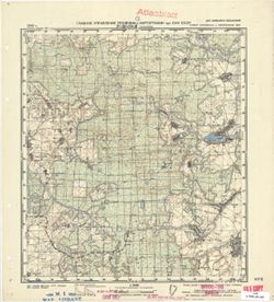
- Description:
- 1936
- Subject:
- Topical Subject: Soviet Union, Geographic Subject: Noviy Bykhov, and Topical Subject: Maps
- Publisher:
- Управление военных топографов РККА
- Language:
- Russian
- Identifier:
- VAC9619-001435
- Genre:
- Military Maps and Topographic Maps
- Geographic Location:
- Coordinates: 53.3333, 30.25, 53.5, 30.5
- Related URL:
- Download GeoTIFF: https://drive.google.com/open?id=1YpmLZJo4Y9OsYLwcwKsyHhgGnXMUDjYr and Catalog URL: http://iucat.iu.edu/catalog/5020131
- Abstract:
- Modern area represented: Noviy Bykhov, Mogilev oblasst, Belarus
- Call Number:
- GM G7000 S50 .S68 N-36-85-Г
- Caption:
- Не подлежит оглашению
- City:
- Нов.Быхов (Noviy Bykhov)
- Copyright Holder:
- No Copyright - United States
- Country:
- СССР (USSR)
- State/Province:
- Белорусская ССР (Byelorussian Soviet Socialist Republic)
- Physical Description:
- Scale: 1:50,000
- Persistent URL:
- http://purl.dlib.indiana.edu/iudl/images/VAC9619/VAC9619-001435
- Provenance:
- DMA Topographic Center, Army Map Service Library, OMAHA, Library of Congress Geography & Map Division
-

- Description:
- 1936
- Subject:
- Geographic Subject: Ludchytsy, Topical Subject: Maps, and Topical Subject: Soviet Union
- Publisher:
- Управление военных топографов РККА
- Language:
- Russian
- Identifier:
- VAC9619-001434
- Genre:
- Military Maps and Topographic Maps
- Geographic Location:
- Coordinates: 53.3333, 30, 53.5, 30.25
- Related URL:
- Catalog URL: http://iucat.iu.edu/catalog/5020131 and Download GeoTIFF: https://drive.google.com/open?id=1bj1iFsVPR0DCUs139aNWM1VgtHomgrCh
- Abstract:
- Modern area represented: Ludchytsy, Mogilev oblast, Belarus
- Call Number:
- GM G7000 S50 .S68 N-36-85-C
- Caption:
- Не подлежит оглашению
- City:
- Лудчица (Ludchytsy)
- Copyright Holder:
- No Copyright - United States
- Country:
- СССР (USSR)
- State/Province:
- Белорусская ССР (Byelorussian Soviet Socialist Republic)
- Physical Description:
- Scale: 1:50,000
- Persistent URL:
- http://purl.dlib.indiana.edu/iudl/images/VAC9619/VAC9619-001434
- Provenance:
- DMA Topographic Center, Army Map Service Library, OMAHA, Library of Congress Geography & Map Division
-

- Description:
- 1936
- Subject:
- Topical Subject: Soviet Union, Topical Subject: Maps, and Geographic Subject: Bykhaw
- Publisher:
- Управление военных топографов
- Language:
- Russian
- Identifier:
- VAC9619-001433
- Genre:
- Military Maps and Topographic Maps
- Geographic Location:
- Coordinates: 53.5, 30.25, 53.6667, 30.5
- Related URL:
- Download GeoTIFF: https://drive.google.com/open?id=1hj66QADhILcwfpUEOSsjQLpFMou58WAj and Catalog URL: http://iucat.iu.edu/catalog/5020131
- Abstract:
- Modern area represented: Bykhaw, Mogilev oblast, Belarus
- Call Number:
- GM G7000 S50 .S68 N-36-85-Б
- Caption:
- Не подлежит оглашению
- City:
- Быхов (Bykhaw)
- Copyright Holder:
- No Copyright - United States
- Country:
- СССР (USSR)
- State/Province:
- Белорусская ССР (Byelorussian Soviet Socialist Republic)
- Physical Description:
- Scale: 1:50,000
- Persistent URL:
- http://purl.dlib.indiana.edu/iudl/images/VAC9619/VAC9619-001433
- Provenance:
- DMA Topographic Center, Army Map Service Library, OMAHA, Library of Congress Geography & Map Division
-
- Description:
- 1936
- Subject:
- Topical Subject: Soviet Union, Topical Subject: Maps, and Geographic Subject: Mokroye
- Publisher:
- Управление военных топографов РККА
- Language:
- Russian
- Identifier:
- VAC9619-001432
- Genre:
- Topographic Maps and Military Maps
- Geographic Location:
- Coordinates: 53.5, 30, 53.6667, 30.25
- Related URL:
- Download GeoTIFF: https://drive.google.com/open?id=1zKP_AP6w61BUYEJWfVOfsyeYbLW1ZAZ- and Catalog URL: http://iucat.iu.edu/catalog/5020131
- Abstract:
- Modern area represented: Mokroye, Mogilev oblast, Belarus
- Call Number:
- GM G7000 S50 .S68 N-36-85-A
- Caption:
- Не подлежит оглашению
- City:
- Мокрое (Mokroye)
- Copyright Holder:
- No Copyright - United States
- Country:
- СССР (USSR)
- State/Province:
- Белорусская ССР (Byelorussian Soviet Socialist Republic)
- Physical Description:
- Scale: 1:50,000
- Persistent URL:
- http://purl.dlib.indiana.edu/iudl/images/VAC9619/VAC9619-001432
- Provenance:
- DMA Topographic Center, Army Map Service Library, OMAHA, Library of Congress Geography & Map Division
-
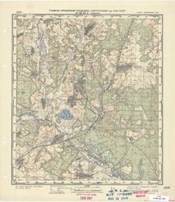
- Description:
- 1940
- Subject:
- Geographic Subject: Veyno, Topical Subject: Maps, and Topical Subject: Soviet Union
- Publisher:
- Главное Управление Геодезии и Картографии при СНК СССР
- Language:
- Russian
- Date Created:
- 1941
- Identifier:
- VAC9619-001431
- Genre:
- Military Maps and Topographic Maps
- Geographic Location:
- Coordinates: 53.6667, 35.75, 53.8667, 36
- Related URL:
- Catalog URL: http://iucat.iu.edu/catalog/5020131 and Download GeoTIFF: https://drive.google.com/open?id=1grHJ7pHQUKP1whRZxmXF7b1IKLZRXyb_
- Abstract:
- Modern area represented: Veyno, Kaluga oblast, Russia
- Call Number:
- GM G7000 S50 .S68 N-36-84-Г
- City:
- Вейно (Veyno)
- Copyright Holder:
- No Copyright - United States
- Country:
- СССР (USSR)
- State/Province:
- Орловская область (Oryol oblast), Тульская область (Tula oblast), РСФСР (RSFSR), and Смоленская область (Smolensk oblast)
- Physical Description:
- Scale: 1:50,000
- Persistent URL:
- http://purl.dlib.indiana.edu/iudl/images/VAC9619/VAC9619-001431
- Provenance:
- Library of Congress Geography & Map Division, Army Map Service Library, OMAHA
-
- Description:
- 1940
- Subject:
- Topical Subject: Soviet Union, Geographic Subject: Slagovishchi, and Topical Subject: Maps
- Publisher:
- Главное Управление Геодезии и Картографии при СНК СССР
- Language:
- Russian
- Date Created:
- 1941
- Identifier:
- VAC9619-001429
- Genre:
- Topographic Maps and Military Maps
- Geographic Location:
- Coordinates: 53.833, 35.75, 54, 36
- Related URL:
- Catalog URL: http://iucat.iu.edu/catalog/5020131 and Download GeoTIFF: https://drive.google.com/open?id=1oqQ_Jwap6JQmn5gSc_0feHfoVhOgIhSE
- Abstract:
- Modern area represented: Slagovishchi, Kaluga oblast, Russia
- Call Number:
- GM G7000 S50 .S68 N-36-84-B
- City:
- Слаговищи (Slagovishchi)
- Copyright Holder:
- No Copyright - United States
- Country:
- СССР (USSR)
- State/Province:
- РСФСР (RSFSR), Тульская область (Tula oblast), and Смоленская область (Smolensk oblast)
- Physical Description:
- Scale: 1:50,000
- Persistent URL:
- http://purl.dlib.indiana.edu/iudl/images/VAC9619/VAC9619-001429
- Provenance:
- G000-30, Atlasblatt, CIA Map Library, M. I. Map Library
-
- Description:
- 1940
- Subject:
- Topical Subject: Soviet Union, Topical Subject: Maps, and Geographic Subject: Ulyanovo Pervoye
- Publisher:
- Главное Управление Геодезии и Картографии при СНК СССР
- Language:
- Russian
- Date Created:
- 1941
- Identifier:
- VAC9619-001430
- Genre:
- Military Maps and Topographic Maps
- Geographic Location:
- Coordinates: 53.6667, 35.5, 53.8667, 35.75
- Related URL:
- Download GeoTIFF: https://drive.google.com/open?id=1HStfzuna63UxK3qn1yGJwA7tEgvWsEXB and Catalog URL: http://iucat.iu.edu/catalog/5020131
- Abstract:
- Modern area represented: Ulyanovo Pervoye, Kaluga oblast, Russia
- Call Number:
- GM G7000 S50 .S68 N-36-84-В
- City:
- Ульяново 1-ое (Ulyanovo Pervoye)
- Copyright Holder:
- No Copyright - United States
- Country:
- СССР (USSR)
- State/Province:
- Смоленская область (Smolensk oblast), Орловская область (Oryol oblast), and РСФСР (RSFSR)
- Physical Description:
- Scale: 1:50,000
- Persistent URL:
- http://purl.dlib.indiana.edu/iudl/images/VAC9619/VAC9619-001430
- Provenance:
- DMA Topographic Center, Army Map Service Library, OMAHA, Library of Congress Geography & Map Division
-
- Description:
- 1940
- Subject:
- Topical Subject: Soviet Union, Geographic Subject: Alëshnya, and Topical Subject: Maps
- Publisher:
- Главное Управление Геодезии и Картографии при СНК СССР
- Language:
- Russian
- Date Created:
- 1941
- Identifier:
- VAC9619-001428
- Genre:
- Topographic Maps and Military Maps
- Geographic Location:
- Coordinates: 53.8667, 35.5, 54, 35.6667
- Related URL:
- Catalog URL: http://iucat.iu.edu/catalog/5020131 and Download GeoTIFF: https://drive.google.com/open?id=1SywiDUNZ4IoJjpuIh7z5o4QfIFvFuzG0
- Abstract:
- Modern area represented: Alëshnya, Kaluga oblast, Russia
- Call Number:
- GM G7000 S50 .S68 N-36-84-A
- City:
- Алешня (Alëshnya)
- Copyright Holder:
- No Copyright - United States
- Country:
- СССР (USSR)
- State/Province:
- Смоленская область (Smolensk oblast), РСФСР (RSFSR), and Орловская область (Oryol oblast)
- Physical Description:
- Scale: 1:50,000
- Persistent URL:
- http://purl.dlib.indiana.edu/iudl/images/VAC9619/VAC9619-001428
- Provenance:
- Library of Congress Geography & Map Division, Army Map Service Library, OMAHA
-
- Description:
- 1940
- Subject:
- Geographic Subject: Chernysheno, Topical Subject: Maps, and Topical Subject: Soviet Union
- Publisher:
- Главное Управление Геодезии и Картографии при СНК СССР
- Language:
- Russian
- Date Created:
- 1941
- Identifier:
- VAC9619-001426
- Genre:
- Topographic Maps and Military Maps
- Geographic Location:
- Coordinates: 53.833, 35.25, 54, 35.5
- Related URL:
- Catalog URL: http://iucat.iu.edu/catalog/5020131 and Download GeoTIFF: https://drive.google.com/open?id=1gi0CWp89K3DqiQbjOF08akJ2ZCWIVRCp
- Abstract:
- Modern area represented: Chernysheno, Kaluga oblast, Russia
- Call Number:
- GM G7000 S50 .S68 N-36-83-B
- Caption:
- Для служебного пользования
- City:
- Чернышино (Chernysheno)
- Copyright Holder:
- No Copyright - United States
- Country:
- СССР (USSR)
- State/Province:
- Смоленская область (Smolensk oblast), Орловская область (Oryol oblast), and РСФСР (RSFSR)
- Physical Description:
- Scale: 1:50,000
- Persistent URL:
- http://purl.dlib.indiana.edu/iudl/images/VAC9619/VAC9619-001426
- Provenance:
- DMA Topographic Center, Army Map Service Library, Library of Congress Geography & Map Division
-
- Description:
- 1940
- Subject:
- Topical Subject: Soviet Union, Geographic Subject: Khotkovo, and Topical Subject: Maps
- Publisher:
- Главное Управление Геодезии и Картографии при СНК СССР
- Language:
- Russian
- Date Created:
- 1941
- Identifier:
- VAC9619-001427
- Genre:
- Military Maps and Topographic Maps
- Geographic Location:
- Coordinates: 53.667, 35, 53.833, 35.25
- Related URL:
- Catalog URL: http://iucat.iu.edu/catalog/5020131 and Download GeoTIFF: https://drive.google.com/open?id=18QTLCAcYe0vn4KzBJYmJBTAc_oV42cOi
- Abstract:
- Modern area represented: Khotkovo, Kaluga oblast, Russia
- Call Number:
- GM G7000 S50 .S68 N-36-83-C
- Caption:
- Для служебного пользования
- City:
- Хатьково (Khotkovo)
- Copyright Holder:
- No Copyright - United States
- Country:
- СССР (USSR)
- State/Province:
- Смоленская область (Smolensk oblast), Орловская область (Oryol oblast), and РСФСР (RSFSR)
- Physical Description:
- Scale: 1:50,000
- Persistent URL:
- http://purl.dlib.indiana.edu/iudl/images/VAC9619/VAC9619-001427
- Provenance:
- G000-30, Atlasblatt, CIA Map Library, M. I. Map Library
-
- Description:
- 1940
- Subject:
- Geographic Subject: Duminichi, Topical Subject: Maps, and Topical Subject: Soviet Union
- Publisher:
- Главное Управление Геодезии и Картографии при СНК СССР
- Language:
- Russian
- Date Created:
- 1941
- Identifier:
- VAC9619-001425
- Genre:
- Topographic Maps and Military Maps
- Geographic Location:
- Coordinates: 53.833, 35, 54, 35.25
- Related URL:
- Download GeoTIFF: https://drive.google.com/open?id=1-OUGxb5wYSJg2BnxEKvEbl5c4H9EJWzr and Catalog URL: http://iucat.iu.edu/catalog/5020131
- Abstract:
- Modern area represented: Duminichi, Kaluga oblast, Russia
- Call Number:
- GM G7000 S50 .S68 N-36-83-A
- City:
- Думиничи (Duminichi)
- Copyright Holder:
- No Copyright - United States
- Country:
- СССР (USSR)
- State/Province:
- Смоленская область (Smolensk oblast) and РСФСР (RSFSR)
- Physical Description:
- Scale: 1:50,000
- Persistent URL:
- http://purl.dlib.indiana.edu/iudl/images/VAC9619/VAC9619-001425
- Provenance:
- G000-30, CIA Map Library, M. I. Map Library
-
- Description:
- 1930
- Subject:
- Topical Subject: Soviet Union, Geographic Subject: Zikeyevo, and Topical Subject: Maps
- Publisher:
- Генеральный штаб РККА
- Language:
- Russian
- Identifier:
- VAC9619-001424
- Genre:
- Topographic Maps and Military Maps
- Geographic Location:
- Coordinates: 53.667, 34.75, 53.833, 35
- Related URL:
- Download GeoTIFF: https://drive.google.com/open?id=1tcWq56iEaisLX1KfeVmHYnM6TAa3jEJQ and Catalog URL: http://iucat.iu.edu/catalog/5020131
- Abstract:
- Modern area represented: Zikeyevo, Kaluga oblast, Russia
- Call Number:
- GM G7000 S50 .S68 N-36-82-D
- City:
- Зикеево (Zikeyevo)
- Copyright Holder:
- No Copyright - United States
- Country:
- СССР (USSR)
- State/Province:
- РСФСР (RSFSR) and Западная область (Western oblast)
- Physical Description:
- Scale: 1:50,000
- Persistent URL:
- http://purl.dlib.indiana.edu/iudl/images/VAC9619/VAC9619-001424
- Provenance:
- Library of Congress Geography & Map Division, Army Map Service Library, OMAHA
-
- Description:
- 1930
- Subject:
- Geographic Subject: Zhizdra, Topical Subject: Maps, and Topical Subject: Soviet Union
- Publisher:
- Генеральный штаб РККА
- Language:
- Russian
- Identifier:
- VAC9619-001423
- Genre:
- Topographic Maps and Military Maps
- Geographic Location:
- Coordinates: 53.667, 34.5, 53.833, 34.75
- Related URL:
- Download GeoTIFF: https://drive.google.com/open?id=1zQ2v9nobsiEBm_JpoLUcbh4HvCFbjj3r and Catalog URL: http://iucat.iu.edu/catalog/5020131
- Abstract:
- Modern area represented: Zhizdra, Kaluga oblast, Russia
- Call Number:
- GM G7000 S50 .S68 N-36-82-B
- City:
- Жиздра (Zhizdra)
- Copyright Holder:
- No Copyright - United States
- Country:
- СССР (USSR)
- State/Province:
- Орловская область (Oryol oblast) and РСФСР (RSFSR)
- Physical Description:
- Scale: 1:50,000
- Persistent URL:
- http://purl.dlib.indiana.edu/iudl/images/VAC9619/VAC9619-001423
- Provenance:
- Library of Congress Geography & Map Division, Army Map Service Library, OMAHA
-
- Description:
- 1930
- Subject:
- Topical Subject: Maps, Geographic Subject: Slobodka, and Topical Subject: Soviet Union
- Publisher:
- Генеральный штаб Красной Армии
- Language:
- Russian
- Identifier:
- VAC9619-001422
- Genre:
- Military Maps and Topographic Maps
- Geographic Location:
- Coordinates: 53.833, 34.75, 54, 35
- Related URL:
- Download GeoTIFF: https://drive.google.com/open?id=1ibplItmCSV4IKnWbdaTGlQcY36HhnhPY and Catalog URL: http://iucat.iu.edu/catalog/5020131
- Abstract:
- Modern area represented: Slobodka, Kaluga oblast, Russia
- Call Number:
- GM G7000 S50 .S68 N-36-82-Б
- City:
- Слободка (Slobodka)
- Copyright Holder:
- No Copyright - United States
- Country:
- СССР (USSR)
- State/Province:
- РСФСР (RSFSR) and Западная область (Western oblast)
- Physical Description:
- Scale: 1:50,000
- Persistent URL:
- http://purl.dlib.indiana.edu/iudl/images/VAC9619/VAC9619-001422
- Provenance:
- DMA Topographic Center, Army Map Service Library, OMAHA, Library of Congress Geography & Map Division
-
- Description:
- 1930
- Subject:
- Topical Subject: Maps, Topical Subject: Soviet Union, and Geographic Subject: Ignatovka
- Publisher:
- Управление военных топографов
- Language:
- Russian
- Identifier:
- VAC9619-001421
- Genre:
- Military Maps and Topographic Maps
- Geographic Location:
- Coordinates: 53.833, 34.5, 54, 34.75
- Related URL:
- Catalog URL: http://iucat.iu.edu/catalog/5020131 and Download GeoTIFF: https://drive.google.com/open?id=1kehJGoSb46U_GsxDGDK6yDdgYo86sJiq
- Abstract:
- Modern area represented: Ignatovka, Kaluga oblast, Russia
- Call Number:
- GM G7000 S50 .S68 N-36-82-A
- City:
- Игнатовка (Ignatovka)
- Copyright Holder:
- No Copyright - United States
- Country:
- СССР (USSR)
- State/Province:
- РСФСР (RSFSR) and Западная область (Western oblast)
- Physical Description:
- Scale: 1:50,000
- Persistent URL:
- http://purl.dlib.indiana.edu/iudl/images/VAC9619/VAC9619-001421
- Provenance:
- DMA Topographic Center, Army Map Service Library, OMAHA, Library of Congress Geography & Map Division
-

- Description:
- 1930
- Subject:
- Topical Subject: Maps, Topical Subject: Soviet Union, and Geographic Subject: Sukreml
- Publisher:
- Генеральный штаб Красной Армии
- Language:
- Russian
- Identifier:
- VAC9619-001420
- Genre:
- Topographic Maps and Military Maps
- Geographic Location:
- Coordinates: 53.667, 34.25, 53.833, 34.5
- Related URL:
- Catalog URL: http://iucat.iu.edu/catalog/5020131 and Download GeoTIFF: https://drive.google.com/open?id=1gsbyY25Dl8kUgEhpHYFe8phG0chVou_F
- Abstract:
- Modern area represented: Sukreml, Kaluga oblast, Russia
- Call Number:
- GM G7000 S50 .S68 N-36-81-Г
- City:
- Сукремль (Sukreml)
- Copyright Holder:
- No Copyright - United States
- Country:
- СССР (USSR)
- State/Province:
- Орловская область (Oryol oblast) and РСФСР (RSFSR)
- Physical Description:
- Scale: 1:50,000
- Persistent URL:
- http://purl.dlib.indiana.edu/iudl/images/VAC9619/VAC9619-001420
- Provenance:
- DMA Topographic Center, Army Map Service Library, OMAHA, Library of Congress Geography & Map Division
-
- Description:
- 1930
- Subject:
- Topical Subject: Maps, Geographic Subject: Batskino, and Topical Subject: Soviet Union
- Publisher:
- Управление военных топографов
- Language:
- Russian
- Identifier:
- VAC9619-001419
- Genre:
- Military Maps and Topographic Maps
- Geographic Location:
- Coordinates: 53.667, 33.75, 53.833, 34
- Related URL:
- Catalog URL: http://iucat.iu.edu/catalog/5020131 and Download GeoTIFF: https://drive.google.com/open?id=15JkxnF7kms4LJrkYAfDeCHq7HHikebGs
- Abstract:
- Modern area represented: Batskino, Bryansk oblast, Russia
- Call Number:
- GM G7000 S50 .S68 N-36-80-Г
- Caption:
- Не подлежит оглашению
- City:
- Бацкино (Batskino)
- Copyright Holder:
- No Copyright - United States
- Country:
- СССР (USSR)
- State/Province:
- РСФСР (RSFSR) and Западная область (Western oblast)
- Physical Description:
- Scale: 1:50,000
- Persistent URL:
- http://purl.dlib.indiana.edu/iudl/images/VAC9619/VAC9619-001419
- Provenance:
- Library of Congress Geography & Map Division, Army Map Service Library, OMAHA
-
- Description:
- 1930
- Subject:
- Topical Subject: Maps, Topical Subject: Soviet Union, and Geographic Subject: Dubrovka
- Publisher:
- Управление военных топографов
- Language:
- Russian
- Identifier:
- VAC9619-001418
- Genre:
- Topographic Maps and Military Maps
- Geographic Location:
- Coordinates: 53.667, 33.5, 53.833, 33.75
- Related URL:
- Download GeoTIFF: https://drive.google.com/open?id=10gvnO5Wh21UDgirMlJ4n326xRE_ULXz5 and Catalog URL: http://iucat.iu.edu/catalog/5020131
- Abstract:
- Modern area represented: Dubrovka, Bryansk oblast, Russia
- Call Number:
- GM G7000 S50 .S68 N-36-80-B
- Caption:
- Не подлежит оглашению
- City:
- Дубровка (Dubrovka)
- Copyright Holder:
- No Copyright - United States
- Country:
- СССР (USSR)
- State/Province:
- Западная область (Western oblast) and РСФСР (RSFSR)
- Physical Description:
- Scale: 1:50,000
- Persistent URL:
- http://purl.dlib.indiana.edu/iudl/images/VAC9619/VAC9619-001418
- Provenance:
- DMA Topographic Center, Army Map Service Library, Library of Congress Geography & Map Division
-
- Description:
- 1930
- Subject:
- Topical Subject: Soviet Union, Geographic Subject: Vetmitsa, and Topical Subject: Maps
- Publisher:
- Управление военных топографов
- Language:
- Russian
- Identifier:
- VAC9619-001417
- Genre:
- Topographic Maps and Military Maps
- Geographic Location:
- Coordinates: 53.833, 33.75, 54, 34
- Related URL:
- Catalog URL: http://iucat.iu.edu/catalog/5020131 and Download GeoTIFF: https://drive.google.com/open?id=1HAhHSNA0lRxPg7TbBBtSLmlHRCxLnLLJ
- Abstract:
- Modern area represented: Vetmitsa, Kaluga oblast, Russia
- Call Number:
- GM G7000 S50 .S68 N-36-80-Б
- Caption:
- Не подлежит оглашению
- City:
- Ветмица (Vetmitsa)
- Copyright Holder:
- No Copyright - United States
- Country:
- СССР (USSR)
- State/Province:
- РСФСР (RSFSR) and Западная область (Western oblast)
- Physical Description:
- Scale: 1:50,000
- Persistent URL:
- http://purl.dlib.indiana.edu/iudl/images/VAC9619/VAC9619-001417
- Provenance:
- DMA Topographic Center, Army Map Service Library
-
- Description:
- 1930
- Subject:
- Geographic Subject: Tyunino, Topical Subject: Soviet Union, and Topical Subject: Maps
- Publisher:
- Управление военных топографов
- Language:
- Russian
- Identifier:
- VAC9619-001416
- Genre:
- Military Maps and Topographic Maps
- Geographic Location:
- Coordinates: 53.833, 33.25, 54, 33.5
- Related URL:
- Catalog URL: http://iucat.iu.edu/catalog/5020131 and Download GeoTIFF: https://drive.google.com/open?id=1EX0m-7VDu0sIE44S6PK9wA8wbVwlEIYX
- Abstract:
- Modern area represented: Tyunino, Bryansk oblast, Russia
- Call Number:
- GM G7000 S50 .S68 N-36-79-Б
- Caption:
- Не подлежит оглашению
- City:
- Тюнино (Tyunino)
- Copyright Holder:
- No Copyright - United States
- Country:
- СССР (USSR)
- State/Province:
- РСФСР (RSFSR) and Западная область (Western oblast)
- Physical Description:
- Scale: 1:50,000
- Persistent URL:
- http://purl.dlib.indiana.edu/iudl/images/VAC9619/VAC9619-001416
- Provenance:
- Library of Congress Geography & Map Division, Army Map Service Library
-
- Description:
- 1930
- Subject:
- Geographic Subject: Aselye, Topical Subject: Maps, and Topical Subject: Soviet Union
- Publisher:
- Управление военных топографов
- Language:
- Russian
- Identifier:
- VAC9619-001415
- Genre:
- Military Maps and Topographic Maps
- Geographic Location:
- Coordinates: 53.8333, 33, 54, 33.25
- Related URL:
- Catalog URL: http://iucat.iu.edu/catalog/5020131 and Download GeoTIFF: https://drive.google.com/open?id=1f_8m2cV9LTbDdJS7VAAz_x-1hFxeHBU8
- Abstract:
- Modern area represented: Aselye, Smolensk oblast, Russia
- Call Number:
- GM G7000 S50 .S68 N-36-79-A
- Caption:
- Не подлежит оглашению
- City:
- Аселье (Aselye)
- Copyright Holder:
- No Copyright - United States
- Country:
- СССР (USSR)
- State/Province:
- РСФСР (RSFSR) and Западная область (Western oblast)
- Physical Description:
- Scale: 1:50,000
- Persistent URL:
- http://purl.dlib.indiana.edu/iudl/images/VAC9619/VAC9619-001415
- Provenance:
- Library of Congress Geography & Map Division, Army Map Service Library, OMAHA
-
- Description:
- 1939
- Subject:
- Geographic Subject: Poselki, Topical Subject: Soviet Union, and Topical Subject: Maps
- Publisher:
- Главное Управление Геодезии и Картографии при СНК СССР
- Language:
- Russian
- Date Created:
- 1941
- Identifier:
- VAC9619-001414
- Genre:
- Military Maps and Topographic Maps
- Geographic Location:
- Coordinates: 53.667, 32.5, 53.833, 32.75
- Related URL:
- Download GeoTIFF: https://drive.google.com/open?id=1c3GJ_0bjXNnIpRcn6VIinpO86PSbBgv2 and Catalog URL: http://iucat.iu.edu/catalog/5020131
- Abstract:
- Modern area represented: Poselki, Smolensk oblast, Russia
- Call Number:
- GM G7000 S50 .S68 N-36-78-B
- Copyright Holder:
- No Copyright - United States
- Country:
- СССР (USSR)
- State/Province:
- Смоленская область (Smolensk oblast), Могилевская область (Mogilev oblast), Белорусская ССР (Byelorussian Soviet Socialist Republic), and РСФСР (RSFSR)
- Physical Description:
- Scale: 1:50,000
- Persistent URL:
- http://purl.dlib.indiana.edu/iudl/images/VAC9619/VAC9619-001414
- Provenance:
- DMA Topographic Center, Army Map Service Library, OMAHA, Library of Congress Geography & Map Division
-
- Description:
- 1924
- Subject:
- Topical Subject: Soviet Union, Geographic Subject: Krivoles, and Topical Subject: Maps
- Publisher:
- Военно-топографическое управление
- Language:
- Russian
- Identifier:
- VAC9619-001413
- Genre:
- Military Maps and Topographic Maps
- Geographic Location:
- Coordinates: 53.833, 32.5, 54, 32.75
- Related URL:
- Catalog URL: http://iucat.iu.edu/catalog/5020131 and Download GeoTIFF: https://drive.google.com/open?id=1G_o1rg9pqVL7KfGLi_tmCMD2EHLl0PBF
- Abstract:
- Modern area represented: Krivoles, Smolensk oblast, Russia
- Call Number:
- GM G7000 S50 .S68 N-36-78-A
- Caption:
- Не подлежит оглашению
- City:
- Криволес (Krivoles)
- Copyright Holder:
- No Copyright - United States
- Country:
- СССР (USSR)
- State/Province:
- РСФСР (RSFSR) and Западная область (Western oblast)
- Physical Description:
- Scale: 1:50,000
- Persistent URL:
- http://purl.dlib.indiana.edu/iudl/images/VAC9619/VAC9619-001413
- Provenance:
- DMA Topographic Center, Army Map Service Library, OMAHA, Library of Congress Geography & Map Division
-
- Description:
- 1931
- Subject:
- Topical Subject: Soviet Union, Topical Subject: Maps, and Geographic Subject: Miloslavichi
- Publisher:
- Генеральный штаб Красной Армии
- Language:
- Russian
- Identifier:
- VAC9619-001412
- Genre:
- Topographic Maps and Military Maps
- Geographic Location:
- Coordinates: 53.667, 32.25, 53.833, 32.5
- Related URL:
- Download GeoTIFF: https://drive.google.com/open?id=1zL-EXnQlM5IdgJLn6CzPa4qZntRBCB8i and Catalog URL: http://iucat.iu.edu/catalog/5020131
- Abstract:
- Modern area represented: Miloslavichi, Mogilev oblast, Belarus
- Call Number:
- GM G7000 S50 .S68 N-36-77-Г
- City:
- Милославичи (Miloslavichi)
- Copyright Holder:
- No Copyright - United States
- Country:
- СССР (USSR)
- State/Province:
- Западная область (Western oblast), Белорусская ССР (Byelorussian Soviet Socialist Republic), and РСФСР (RSFSR)
- Physical Description:
- Scale: 1:50,000
- Persistent URL:
- http://purl.dlib.indiana.edu/iudl/images/VAC9619/VAC9619-001412
- Provenance:
- DMA Topographic Center, Army Map Service Library, Library of Congress Geography & Map Division
-
- Description:
- 1928
- Subject:
- Geographic Subject: Koroblëvo, Topical Subject: Maps, and Topical Subject: Soviet Union
- Publisher:
- Военно-топографическое управление
- Language:
- Russian
- Identifier:
- VAC9619-001411
- Genre:
- Topographic Maps and Military Maps
- Geographic Location:
- Coordinates: 53.6667, 32, 53.8333, 32.25
- Related URL:
- Catalog URL: http://iucat.iu.edu/catalog/5020131 and Download GeoTIFF: https://drive.google.com/open?id=1wQE5m4bzv_A5oMlH7hfDnovRECBmoRoI
- Abstract:
- Modern area represented: Koroblëvo, Smolensk oblast, Russia
- Call Number:
- GM G7000 S50 .S68 N-36-77-B
- Caption:
- Не подлежит оглашению
- City:
- Короблево (Koroblëvo)
- Copyright Holder:
- No Copyright - United States
- Country:
- СССР (USSR)
- State/Province:
- Западная область (Western oblast), РСФСР (RSFSR), and Белорусская ССР (Byelorussian Soviet Socialist Republic)
- Physical Description:
- Scale: 1:50,000
- Persistent URL:
- http://purl.dlib.indiana.edu/iudl/images/VAC9619/VAC9619-001411
- Provenance:
- DMA Topographic Center, Army Map Service Library, OMAHA, Library of Congress Geography & Map Division
-
- Description:
- 1924
- Subject:
- Topical Subject: Maps, Geographic Subject: Shumyachi, and Topical Subject: Soviet Union
- Publisher:
- Военно-топографическое управление
- Language:
- Russian
- Identifier:
- VAC9619-001410
- Genre:
- Topographic Maps and Military Maps
- Geographic Location:
- Coordinates: 53.833, 32.25, 54, 32.5
- Related URL:
- Download GeoTIFF: https://drive.google.com/open?id=1WT6NFdOhzbK4jC5COvBYwZKNdH4UugWY and Catalog URL: http://iucat.iu.edu/catalog/5020131
- Abstract:
- Modern area represented: Shumyachi, Smolensk oblast, Russia
- Call Number:
- GM G7000 S50 .S68 N-36-77-Б
- Caption:
- Не подлежит оглашению
- City:
- Щумячи (Shumyachi)
- Copyright Holder:
- No Copyright - United States
- Country:
- СССР (USSR)
- State/Province:
- Западная область (Western oblast) and РСФСР (RSFSR)
- Physical Description:
- Scale: 1:50,000
- Persistent URL:
- http://purl.dlib.indiana.edu/iudl/images/VAC9619/VAC9619-001410
- Provenance:
- Library of Congress Geography & Map Division, Army Map Service Library, OMAHA
-
- Description:
- 1924
- Subject:
- Topical Subject: Maps, Topical Subject: Soviet Union, and Geographic Subject: Petrovichi
- Publisher:
- Военно-топографическое управление
- Language:
- Russian
- Identifier:
- VAC9619-001409
- Genre:
- Topographic Maps and Military Maps
- Geographic Location:
- Coordinates: 53.833, 32, 54, 32.25
- Related URL:
- Catalog URL: http://iucat.iu.edu/catalog/5020131 and Download GeoTIFF: https://drive.google.com/open?id=1uARS6c42902TVqirRCjVUMeGbN539REj
- Abstract:
- Modern area represented: Petrovichi, Smolensk oblast, Russia
- Call Number:
- GM G7000 S50 .S68 N-36-77-A
- Caption:
- Не подлежит оглашению
- City:
- Петровичи (Petrovichi)
- Copyright Holder:
- No Copyright - United States
- Country:
- СССР (USSR)
- State/Province:
- РСФСР (RSFSR) and Западная область (Western oblast)
- Physical Description:
- Scale: 1:50,000
- Persistent URL:
- http://purl.dlib.indiana.edu/iudl/images/VAC9619/VAC9619-001409
- Provenance:
- Library of Congress Geography & Map Division, Army Map Service Library, OMAHA
-
- Description:
- 1924
- Subject:
- Topical Subject: Maps, Geographic Subject: Paradino, and Topical Subject: Soviet Union
- Publisher:
- Управление военных топографов
- Language:
- Russian
- Date Created:
- 1930
- Identifier:
- VAC9619-001407
- Genre:
- Topographic Maps and Military Maps
- Geographic Location:
- Coordinates: 53.833, 31.75, 54, 32
- Related URL:
- Download GeoTIFF: https://drive.google.com/open?id=1AhOKXg8J2ZdNFGTxJTkCtYk-xvD_Ga-G and Catalog URL: http://iucat.iu.edu/catalog/5020131
- Abstract:
- Modern area represented: Paradino, Mogilev oblast, Belarus
- Call Number:
- GM G7000 S50 .S68 N-36-76-Б
- Caption:
- Не подлежит оглашению
- City:
- Парадино (Paradino)
- Copyright Holder:
- No Copyright - United States
- Country:
- СССР (USSR)
- State/Province:
- Западная область (Western oblast), Белорусская ССР (Byelorussian Soviet Socialist Republic), and РСФСР (RSFSR)
- Physical Description:
- Scale: 1:50,000
- Persistent URL:
- http://purl.dlib.indiana.edu/iudl/images/VAC9619/VAC9619-001407
- Provenance:
- Library of Congress Geography & Map Division, Army Map Service Library, OMAHA
-

- Description:
- 1928
- Subject:
- Topical Subject: Maps, Geographic Subject: Poloshkovo, and Topical Subject: Soviet Union
- Publisher:
- Военно-топографическое управление
- Language:
- Russian
- Identifier:
- VAC9619-001408
- Genre:
- Topographic Maps and Military Maps
- Geographic Location:
- Coordinates: 53.667, 31.75, 53.833, 32
- Related URL:
- Catalog URL: http://iucat.iu.edu/catalog/5020131 and Download GeoTIFF: https://drive.google.com/open?id=1r4Lrhmr24a9Yxrj1mJ0PjA5cN4g9g_o2
- Abstract:
- Modern area represented: Poloshkovo, Mogilev oblast, Belarus
- Call Number:
- GM G7000 S50 .S68 N-36-76-Г
- Caption:
- Не подлежит оглашению
- City:
- Полошково (Poloshkovo)
- Copyright Holder:
- No Copyright - United States
- Country:
- СССР (USSR)
- State/Province:
- Западная область (Western oblast), Белорусская ССР (Byelorussian Soviet Socialist Republic), and РСФСР (RSFSR)
- Physical Description:
- Scale: 1:50,000
- Persistent URL:
- http://purl.dlib.indiana.edu/iudl/images/VAC9619/VAC9619-001408
- Provenance:
- Library of Congress Geography & Map Division, Army Map Service Library, OMAHA
-
- Description:
- 1924
- Subject:
- Topical Subject: Maps, Topical Subject: Soviet Union, and Geographic Subject: Molyatichi
- Publisher:
- Военно-топографическое управление
- Language:
- Russian
- Date Created:
- 1930
- Identifier:
- VAC9619-001406
- Genre:
- Topographic Maps and Military Maps
- Geographic Location:
- Coordinates: 53.833, 31.5, 54, 31.75
- Related URL:
- Catalog URL: http://iucat.iu.edu/catalog/5020131 and Download GeoTIFF: https://drive.google.com/open?id=1mDv-xjRxQ9MN0tnibRm-9T4vbq1BeRhJ
- Abstract:
- Modern area represented: Molyatichi, Mogilev oblast, Belarus
- Call Number:
- GM G7000 S50 .S68 N-36-76-A
- Caption:
- Не подлежит оглашению
- City:
- Молятичи (Molyatichi)
- Copyright Holder:
- No Copyright - United States
- Country:
- СССР (USSR)
- State/Province:
- Белорусская ССР (Byelorussian Soviet Socialist Republic)
- Physical Description:
- Scale: 1:50,000
- Persistent URL:
- http://purl.dlib.indiana.edu/iudl/images/VAC9619/VAC9619-001406
- Provenance:
- DMA Topographic Center, Army Map Service Library, OMAHA, Library of Congress Geography & Map Division
-
- Description:
- 1928
- Subject:
- Topical Subject: Soviet Union, Topical Subject: Maps, and Geographic Subject: Gubinshchina
- Publisher:
- Управление военных топографов РККА
- Language:
- Russian
- Identifier:
- VAC9619-001405
- Genre:
- Military Maps and Topographic Maps
- Geographic Location:
- Coordinates: 53.667, 31.25, 53.833, 31.5
- Related URL:
- Download GeoTIFF: https://drive.google.com/open?id=1FfCYB1nIHIlZ1jVTEZ7WWXl6WsO3i5Nb and Catalog URL: http://iucat.iu.edu/catalog/5020131
- Abstract:
- Modern area represented: Gubinshchina, Mogilev oblast, Belarus
- Call Number:
- GM G7000 S50 .S68 N-36-75-Г
- Caption:
- Не подлежит оглашению
- City:
- Губенщина (Gubinshchina)
- Copyright Holder:
- No Copyright - United States
- Country:
- СССР (USSR)
- State/Province:
- Белорусская ССР (Byelorussian Soviet Socialist Republic)
- Physical Description:
- Scale: 1:50,000
- Persistent URL:
- http://purl.dlib.indiana.edu/iudl/images/VAC9619/VAC9619-001405
- Provenance:
- DMA Topographic Center, Army Map Service Library, OMAHA, Library of Congress Geography & Map Division
-
- Description:
- 1928
- Subject:
- Topical Subject: Soviet Union, Geographic Subject: Riminka, and Topical Subject: Maps
- Publisher:
- Военно-топографическое управление
- Language:
- Russian
- Identifier:
- VAC9619-001404
- Genre:
- Military Maps and Topographic Maps
- Geographic Location:
- Coordinates: 53.667, 31, 53.833, 31.25
- Related URL:
- Download GeoTIFF: https://drive.google.com/open?id=1GPWuT8Lah4EvIdKqM-jFeE2azGVPUROC and Catalog URL: http://iucat.iu.edu/catalog/5020131
- Abstract:
- Modern area represented: Riminka, Mogilev oblast, Belarus
- Call Number:
- GM G7000 S50 .S68 N-36-75-B
- Caption:
- Секретно
- City:
- Рыминка (Riminka)
- Copyright Holder:
- No Copyright - United States
- Country:
- СССР (USSR)
- State/Province:
- Белорусская ССР (Byelorussian Soviet Socialist Republic)
- Physical Description:
- Scale: 1:50,000
- Persistent URL:
- http://purl.dlib.indiana.edu/iudl/images/VAC9619/VAC9619-001404
- Provenance:
- DMA Topographic Center, Army Map Service Library, OMAHA, Library of Congress Geography & Map Division
-
- Description:
- 1924
- Subject:
- Topical Subject: Soviet Union, Topical Subject: Maps, and Geographic Subject: Uspolye
- Publisher:
- Военно-топографическое управление
- Language:
- Russian
- Identifier:
- VAC9619-001403
- Genre:
- Topographic Maps and Military Maps
- Geographic Location:
- Coordinates: 53.833, 31.25, 54, 31.5
- Related URL:
- Download GeoTIFF: https://drive.google.com/open?id=1IwL0j5cVqx56h2evV-RTyTR6-ykjeqiH and Catalog URL: http://iucat.iu.edu/catalog/5020131
- Abstract:
- Modern area represented: Uspolye, Mogilev oblast, Belarus
- Call Number:
- GM G7000 S50 .S68 N-36-75-Б
- Caption:
- Секретно
- City:
- Усполье (Uspolye)
- Copyright Holder:
- No Copyright - United States
- Country:
- СССР (USSR)
- State/Province:
- Белорусская ССР (Byelorussian Soviet Socialist Republic)
- Physical Description:
- Scale: 1:50,000
- Persistent URL:
- http://purl.dlib.indiana.edu/iudl/images/VAC9619/VAC9619-001403
- Provenance:
- Library of Congress Geography & Map Division, Army Map Service Library, OMAHA
-
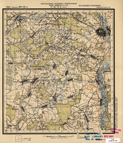
- Description:
- 1923
- Subject:
- Topical Subject: Maps, Geographic Subject: Chavusi, and Topical Subject: Soviet Union
- Publisher:
- Управление военных топографов
- Language:
- Russian
- Date Created:
- 1926
- Identifier:
- VAC9619-001402
- Genre:
- Topographic Maps and Military Maps
- Geographic Location:
- Coordinates: 53.667, 30.75, 53.833, 31
- Related URL:
- Catalog URL: http://iucat.iu.edu/catalog/5020131 and Download GeoTIFF: https://drive.google.com/open?id=19RCJP_F7aEs1hzwZ1krEnOEdA-MdnvHR
- Abstract:
- Modern area represented: Chavusi, Mogilev oblast, Belarus
- Call Number:
- GM G7000 S50 .S68 N-36-74-Г
- Caption:
- Не подлежит оглашению
- City:
- Чаусы (Chavusi)
- Copyright Holder:
- No Copyright - United States
- Country:
- СССР (USSR)
- State/Province:
- Белорусская ССР (Byelorussian Soviet Socialist Republic)
- Physical Description:
- Scale: 1:50,000
- Persistent URL:
- http://purl.dlib.indiana.edu/iudl/images/VAC9619/VAC9619-001402
- Provenance:
- M. I. Map Library
-
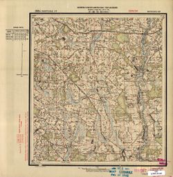
- Description:
- 1929
- Subject:
- Geographic Subject: Goleni, Topical Subject: Soviet Union, and Topical Subject: Maps
- Publisher:
- Военно-топографическое управление
- Language:
- Russian
- Identifier:
- VAC9619-001401
- Genre:
- Military Maps and Topographic Maps
- Geographic Location:
- Coordinates: 53.667, 30.5, 53.833, 30.75
- Related URL:
- Catalog URL: http://iucat.iu.edu/catalog/5020131 and Download GeoTIFF: https://drive.google.com/open?id=1BV4Dwp8i4A8x77fOV4CI3WD0Vl_svmlS
- Abstract:
- Modern area represented: Goleni, Mogilev oblast, Belarus
- Call Number:
- GM G7000 S50 .S68 N-36-74-B
- Caption:
- Секретно
- City:
- Голени (Goleni)
- Copyright Holder:
- No Copyright - United States
- Country:
- СССР (USSR)
- State/Province:
- Белорусская ССР (Byelorussian Soviet Socialist Republic) and Могилевский округ (Mogilev district)
- Physical Description:
- Scale: 1:50,000
- Persistent URL:
- http://purl.dlib.indiana.edu/iudl/images/VAC9619/VAC9619-001401
- Provenance:
- M. I. Map Library
-
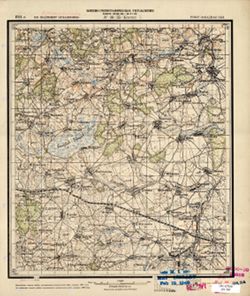
- Description:
- 1924
- Subject:
- Topical Subject: Maps, Topical Subject: Soviet Union, and Geographic Subject: Brin
- Publisher:
- Военно-топографическое управление
- Language:
- Russian
- Identifier:
- VAC9619-001347
- Genre:
- Military Maps and Topographic Maps
- Geographic Location:
- Coordinates: 54.5, 33.25, 54.667, 33.5
- Related URL:
- Download GeoTIFF: https://drive.google.com/open?id=1inzY5HvVpNum-28aV5Tivqnw46aSvPU3 and Catalog URL: http://iucat.iu.edu/catalog/5020131
- Abstract:
- Modern area represented: Brin, Smolensk oblast, Russia
- Call Number:
- GM G7000 S50 .S68 N-36-55-Б
- Caption:
- Не подлежит оглашению
- City:
- Брин (Brin)
- Copyright Holder:
- No Copyright - United States
- Country:
- СССР (USSR)
- State/Province:
- РСФСР (RSFSR) and Западная область (Western oblast)
- Physical Description:
- Scale: 1:50,000
- Persistent URL:
- http://purl.dlib.indiana.edu/iudl/images/VAC9619/VAC9619-001347
- Provenance:
- M. I. Map Library, G000-30, GS, RA, Atlasblatt
-
- Description:
- 1909
- Subject:
- Topical Subject: Soviet Union, Topical Subject: Maps, and Geographic Subject: Volodymyrets
- Publisher:
- Генеральный штаб РККА
- Language:
- Russian
- Date Created:
- 1937
- Identifier:
- VAC9619-004220
- Genre:
- Military Maps and Topographic Maps
- Geographic Location:
- Coordinates: 51.333333, 26.0, 51.666667, 26.5
- Related URL:
- Download GeoTIFF: https://drive.google.com/file/d/1FJ4lP-wMk-_7FSfX6i9KmFPfGWL9v7qW/view?usp=sharing and Catalog URL: https://iucat.iu.edu/catalog/5020129
- Abstract:
- Modern area represented: Volodymyrets, Rivne oblast, Ukraine
- Call Number:
- G7000 s100 .S7 sheet M-35-17
- City:
- Влодзимежец (Vlodzimezhets)
- Copyright Holder:
- No Copyright - United States
- Country:
- СССР (USSR)
- State/Province:
- Ровенская область (Rivne oblast) and Украинская ССР (Ukrainian Soviet Socialist Republic)
- Physical Description:
- Scale: 1:100,000
- Persistent URL:
- http://purl.dlib.indiana.edu/iudl/images/VAC9619/VAC9619-004220
- Provenance:
- DMA Topographic Center, Army Map Service Library, OMAHA, Library of Congress Geography & Map Division
-
- Description:
- 1937
- Subject:
- Topical Subject: Soviet Union, Geographic Subject: Dmitriyev-Lgovsky, and Topical Subject: Maps
- Publisher:
- Генеральный штаб Красной Армии
- Language:
- Russian
- Date Created:
- 1941
- Identifier:
- VAC9619-004218
- Genre:
- Military Maps and Topographic Maps
- Geographic Location:
- Coordinates: 52, 35, 52.333, 35.5
- Related URL:
- Download GeoTIFF: https://drive.google.com/file/d/1OU-PVQJtaPUnp5IG0TGZRRUM5u8JC2BC/view?usp=sharing and Catalog URL: https://iucat.iu.edu/catalog/5020129
- Abstract:
- Modern area represented: Dmitriyev-Lgovsky, Kursk oblast, Russia
- Call Number:
- G7000 s100 .S7 sheet N-36-143
- City:
- Дмитриев (Dmitriyev)
- Copyright Holder:
- No Copyright - United States
- Country:
- СССР (USSR)
- State/Province:
- Курская область (Kursk oblast) and РСФСР (RSFSR)
- Physical Description:
- Scale: 1:100,000
- Persistent URL:
- http://purl.dlib.indiana.edu/iudl/images/VAC9619/VAC9619-004218
- Provenance:
- DMA Topographic Center, Army Map Service Library, Atlasblatt
-
- Description:
- 1938
- Subject:
- Topical Subject: Soviet Union, Topical Subject: Maps, and Geographic Subject: Seredyna-Buda
- Publisher:
- Генеральный штаб Красной Армии
- Language:
- Russian
- Date Created:
- 1940
- Identifier:
- VAC9619-004217
- Genre:
- Military Maps and Topographic Maps
- Geographic Location:
- Coordinates: 52, 34, 52.333, 34.5
- Related URL:
- Download GeoTIFF: https://drive.google.com/file/d/12CMl-5dr0jrOhTKQkJToT1jgUDsmInld/view?usp=sharing and Catalog URL: https://iucat.iu.edu/catalog/5020129
- Abstract:
- Modern area represented: Seredyna-Buda, Sumy oblast, Ukraine
- Call Number:
- G7000 s100 .S7 sheet N-36-141
- City:
- Середина-Буда (Seredyna-Buda)
- Copyright Holder:
- No Copyright - United States
- Country:
- СССР (USSR)
- State/Province:
- РСФСР (RSFSR) and Украинская ССР (Ukrainian Soviet Socialist Republic)
- Physical Description:
- Scale: 1:100,000
- Persistent URL:
- http://purl.dlib.indiana.edu/iudl/images/VAC9619/VAC9619-004217
- Provenance:
- Army Map Service Library, Library of Congress G & M Division
-

- Description:
- 1938
- Subject:
- Geographic Subject: Novhorod-Siverskyy, Topical Subject: Maps, and Topical Subject: Soviet Union
- Publisher:
- Главное Управление Геодезии и Картографии при СНК СССР
- Language:
- Russian
- Date Created:
- 1941
- Identifier:
- VAC9619-004216
- Genre:
- Military Maps and Topographic Maps
- Geographic Location:
- Coordinates: 52, 33, 52.333, 33.5
- Related URL:
- Download GeoTIFF: https://drive.google.com/file/d/1kaJZgYyUS6Hj_BGfB5UeL-vO4ElM_lO7/view?usp=sharing and Catalog URL: https://iucat.iu.edu/catalog/5020129
- Abstract:
- Modern area represented: Novhorod-Siverskyy, Chernihiv oblast, Ukraine
- Call Number:
- G7000 s100 .S7 sheet N-36-139
- Caption:
- Для служебного пользования
- City:
- Новгород-Северский (Novhorod-Siverskyy)
- Copyright Holder:
- No Copyright - United States
- Country:
- СССР (USSR)
- State/Province:
- Черниговская область (Chernihiv oblast), Украинская ССР (Ukrainian Soviet Socialist Republic), Сумская область (Sumy oblast), РСФСР (RSFSR), and Орловская об...
- Physical Description:
- Scale: 1:100,000
- Persistent URL:
- http://purl.dlib.indiana.edu/iudl/images/VAC9619/VAC9619-004216
- Provenance:
- DMA Topographic Center, Army Map Service Library, OMAHA, Library of Congress Geography & Map Division
-
- Description:
- 1938
- Subject:
- Topical Subject: Maps, Topical Subject: Soviet Union, and Geographic Subject: Semënovka
- Publisher:
- Главное Управление Геодезии и Картографии при СНК СССР
- Language:
- Russian
- Identifier:
- VAC9619-004215
- Genre:
- Military Maps and Topographic Maps
- Geographic Location:
- Coordinates: 52, 32.5, 52.333, 33
- Related URL:
- Download GeoTIFF: https://drive.google.com/file/d/1fV1jj8bxfosoNzFaEIgOetNrQvRV5gum/view?usp=sharing and Catalog URL: https://iucat.iu.edu/catalog/5020129
- Abstract:
- Modern area represented: Semënovka, Russia
- Call Number:
- G7000 s100 .S7 sheet N-36-138
- Caption:
- Для служебного пользования
- City:
- Семеновка (Semënovka)
- Copyright Holder:
- No Copyright - United States
- Country:
- СССР (USSR)
- State/Province:
- Украинская ССР (Ukrainian Soviet Socialist Republic), Орловская область (Oryol oblast), РСФСР (RSFSR), and Черниговская область (Chernihiv oblast)
- Physical Description:
- Scale: 1:100,000
- Persistent URL:
- http://purl.dlib.indiana.edu/iudl/images/VAC9619/VAC9619-004215
- Provenance:
- DMA Topographic Center, Army Map Service Library, OMAHA, Atlasblatt, Library of Congress Geography & Map Division, Geographic Names Branch
-

- Description:
- 1930
- Subject:
- Topical Subject: Soviet Union, Topical Subject: Maps, and Geographic Subject: Novyy Ropsk
- Publisher:
- Генеральный штаб Красной Армии
- Language:
- Russian
- Identifier:
- VAC9619-004214
- Genre:
- Military Maps and Topographic Maps
- Geographic Location:
- Coordinates: 52, 32, 52.333, 32.5
- Related URL:
- Catalog URL: https://iucat.iu.edu/catalog/5020129 and Download GeoTIFF: https://drive.google.com/file/d/1ygDvmMikKrimtW0Ij306dCFLQr69wqQR/view?usp=sharing
- Abstract:
- Modern area represented: Novyy Ropsk, Bryansk oblast, Russia
- Call Number:
- G7000 s100 .S7 sheet N-36-137
- City:
- Новый Ропск (Novyy Ropsk)
- Copyright Holder:
- No Copyright - United States
- Country:
- СССР (USSR)
- State/Province:
- Украинская ССР (Ukrainian Soviet Socialist Republic), РСФСР (RSFSR), Орловская область (Oryol oblast), and Черниговская область (Chernihiv oblast)
- Physical Description:
- Scale: 1:100,000
- Persistent URL:
- http://purl.dlib.indiana.edu/iudl/images/VAC9619/VAC9619-004214
- Provenance:
- DMA Topographic Center, Army Map Service Library, OMAHA, Library of Congress Geography & Map Division
-

- Description:
- 1923
- Subject:
- Topical Subject: Maps, Topical Subject: Soviet Union, and Geographic Subject: Ogorodnya
- Publisher:
- Генеральный штаб Красной Армии
- Language:
- Russian
- Date Created:
- 1941
- Identifier:
- VAC9619-004213
- Genre:
- Topographic Maps and Military Maps
- Geographic Location:
- Coordinates: 52, 31.5, 52.333, 32
- Related URL:
- Download GeoTIFF: https://drive.google.com/file/d/1MuU_oyIyusePmX5IlnPsAE4zUOKWaE3e/view?usp=sharing and Catalog URL: https://iucat.iu.edu/catalog/5020129
- Abstract:
- Modern area represented: Ogorodnya, Homyel voblasc, Belarus
- Call Number:
- G7000 s100 .S7 sheet N-36-136
- City:
- Огородня-Гомельская (Ogorodnya-Gomelskaya)
- Copyright Holder:
- No Copyright - United States
- Country:
- СССР (USSR)
- State/Province:
- Орловская область (Oryol oblast), Украинская ССР (Ukrainian Soviet Socialist Republic), Белорусская ССР (Byelorussian Soviet Socialist Republic), Черниговска...
- Physical Description:
- Scale: 1:100,000
- Persistent URL:
- http://purl.dlib.indiana.edu/iudl/images/VAC9619/VAC9619-004213
- Provenance:
- DMA Topographic Center, Army Map Service Library
-
- Description:
- 1929
- Subject:
- Topical Subject: Maps, Geographic Subject: Kholmech, and Topical Subject: Soviet Union
- Publisher:
- Генеральный штаб Красной Армии
- Language:
- Russian
- Identifier:
- VAC9619-004212
- Genre:
- Military Maps and Topographic Maps
- Geographic Location:
- Coordinates: 52, 30.5, 52.333, 31
- Related URL:
- Download GeoTIFF: https://drive.google.com/file/d/1sZ4E0O2ydGxqDYrqDX_B7C6U3DK1jkmT/view?usp=sharing and Catalog URL: https://iucat.iu.edu/catalog/5020129
- Abstract:
- Modern area represented: Kholmech, Homyel oblast, Belarus
- Call Number:
- G7000 s100 .S7 sheet N-36-134
- City:
- Холмечь (Kholmech)
- Copyright Holder:
- No Copyright - United States
- Country:
- СССР (USSR)
- State/Province:
- Белорусская ССР (Byelorussian Soviet Socialist Republic)
- Physical Description:
- Scale: 1:100,000
- Persistent URL:
- http://purl.dlib.indiana.edu/iudl/images/VAC9619/VAC9619-004212
- Provenance:
- DMA Topographic Center, Army Map Service Library, Geographic Names Branch, OMAHA, Library of Congress Geography & Map Division
-
- Description:
- 1929
- Subject:
- Topical Subject: Maps, Geographic Subject: Malodusha, and Topical Subject: Soviet Union
- Publisher:
- Генеральный штаб РККА
- Language:
- Russian
- Date Created:
- 1930
- Identifier:
- VAC9619-004211
- Genre:
- Military Maps and Topographic Maps
- Geographic Location:
- Coordinates: 52, 30, 52.333, 30.5
- Related URL:
- Download GeoTIFF: https://drive.google.com/file/d/1vss8uAeY0wn5MsDvFBZiLPkPyXj1hMDz/view?usp=sharing and Catalog URL: https://iucat.iu.edu/catalog/5020129
- Abstract:
- Modern area represented: Malodusha, Homyel oblast, Belarus
- Call Number:
- G7000 s100 .S7 sheet N-36-133
- Caption:
- Не подлежит оглашению
- City:
- Малодуш (Malodush)
- Copyright Holder:
- No Copyright - United States
- Country:
- СССР (USSR)
- State/Province:
- Белорусская ССР (Byelorussian Soviet Socialist Republic)
- Physical Description:
- Scale: 1:100,000
- Persistent URL:
- http://purl.dlib.indiana.edu/iudl/images/VAC9619/VAC9619-004211
- Provenance:
- DMA Topographic Center, Army Map Service Library, OMAHA, Library of Congress Geography & Map Division
-
- Description:
- 1937
- Subject:
- Topical Subject: Soviet Union, Geographic Subject: Trosna, and Topical Subject: Maps
- Publisher:
- Генеральный штаб Красной Армии
- Language:
- Russian
- Date Created:
- 1941
- Identifier:
- VAC9619-004210
- Genre:
- Topographic Maps and Military Maps
- Geographic Location:
- Coordinates: 52.333, 35.5, 52.667, 36
- Related URL:
- Download GeoTIFF: https://drive.google.com/file/d/1SObrMdlPW93jIi7PNPWF7rb-NcZPRbX-/view?usp=sharing and Catalog URL: https://iucat.iu.edu/catalog/5020129
- Abstract:
- Modern area represented: Trosna, Oryol oblast, Russia
- Call Number:
- G7000 s100 .S7 sheet N-36-132
- City:
- Тросна (Trosna)
- Copyright Holder:
- No Copyright - United States
- Country:
- СССР (USSR)
- State/Province:
- Курская область (Kursk oblast), РСФСР (RSFSR), and Орловская область (Oryol oblast)
- Physical Description:
- Scale: 1:100,000
- Persistent URL:
- http://purl.dlib.indiana.edu/iudl/images/VAC9619/VAC9619-004210
- Provenance:
- DMA Topographic Center, Auswärtiges Amt. Geographischer Dienst, OMAHA, Army Map Service Library, Library of Congress Geography & Map Division
-
- Description:
- 1937
- Subject:
- Topical Subject: Soviet Union, Geographic Subject: Dmitrovsk-Orlovskiy, and Topical Subject: Maps
- Publisher:
- Генеральный штаб Красной Армии
- Language:
- Russian
- Date Created:
- 1941
- Identifier:
- VAC9619-004209
- Genre:
- Military Maps and Topographic Maps
- Geographic Location:
- Coordinates: 52.333, 35, 52.667, 35.5
- Related URL:
- Download GeoTIFF: https://drive.google.com/file/d/109bdr_Kvs4aWF_lC7_XhQ3-WPlXh0_9r/view?usp=sharing and Catalog URL: https://iucat.iu.edu/catalog/5020129
- Abstract:
- Modern area represented: Dmitrovsk-Orlovskiy, Oryol oblast, Russia
- Call Number:
- G7000 s100 .S7 sheet N-36-131
- City:
- Дмитровск (Dmitrovsk-Orlovskiy)
- Copyright Holder:
- No Copyright - United States
- Country:
- СССР (USSR)
- State/Province:
- Орловская область (Oryol oblast), Курская область (Kursk oblast), and РСФСР (RSFSR)
- Physical Description:
- Scale: 1:100,000
- Persistent URL:
- http://purl.dlib.indiana.edu/iudl/images/VAC9619/VAC9619-004209
- Provenance:
- DMA Topographic Center, Army Map Service Library, Geographic Names Branch, Atlasblatt
-
- Description:
- 1937
- Subject:
- Geographic Subject: Lokot, Topical Subject: Soviet Union, and Topical Subject: Maps
- Publisher:
- Генеральный штаб Красной Армии
- Language:
- Russian
- Date Created:
- 1941
- Identifier:
- VAC9619-004208
- Genre:
- Military Maps and Topographic Maps
- Geographic Location:
- Coordinates: 52.333, 34.5, 52.667, 35
- Related URL:
- Download GeoTIFF: https://drive.google.com/file/d/1dYlbw4GTkP_oEsATxRiDM_A91PnKgqrP/view?usp=sharing and Catalog URL: https://iucat.iu.edu/catalog/5020129
- Abstract:
- Modern area represented: Lokot, Bryansk oblast, Russia
- Call Number:
- G7000 s100 .S7 sheet N-36-130
- City:
- Локоть (Lokot)
- Copyright Holder:
- No Copyright - United States
- Country:
- СССР (USSR)
- State/Province:
- Курская область (Kursk oblast), Орловская область (Oryol oblast), and РСФСР (RSFSR)
- Physical Description:
- Scale: 1:100,000
- Persistent URL:
- http://purl.dlib.indiana.edu/iudl/images/VAC9619/VAC9619-004208
- Provenance:
- DMA Topographic Center, Army Map Service Library, OMAHA, Library of Congress Geography & Map Division
-
- Description:
- 1940
- Subject:
- Topical Subject: Soviet Union, Topical Subject: Maps, and Geographic Subject: Kokorevka
- Publisher:
- Генеральный штаб Красной Армии
- Language:
- Russian
- Date Created:
- 1941
- Identifier:
- VAC9619-004207
- Genre:
- Military Maps and Topographic Maps
- Geographic Location:
- Coordinates: 52.333, 34, 52.667, 34.5
- Related URL:
- Download GeoTIFF: https://drive.google.com/file/d/1CdDXPK4iRkp14Oevzjr2qlP9hpMw0YQ_/view?usp=sharing and Catalog URL: https://iucat.iu.edu/catalog/5020129
- Abstract:
- Modern area represented: Kokorevka, Bryansk oblast, Russia
- Call Number:
- G7000 s100 .S7 sheet N-36-129
- City:
- Кокоревка (Kokorevka)
- Copyright Holder:
- No Copyright - United States
- Country:
- СССР (USSR)
- State/Province:
- РСФСР (RSFSR) and Орловская область (Oryol oblast)
- Physical Description:
- Scale: 1:100,000
- Persistent URL:
- http://purl.dlib.indiana.edu/iudl/images/VAC9619/VAC9619-004207
- Provenance:
- DMA Topographic Center, Army Map Service Library, Geographic Names Branch, OMAHA
-
- Description:
- 1940
- Subject:
- Geographic Subject: Trubchevsk, Topical Subject: Maps, and Topical Subject: Soviet Union
- Publisher:
- Генеральный штаб Красной Армии
- Language:
- Russian
- Date Created:
- 1941
- Identifier:
- VAC9619-004206
- Genre:
- Military Maps and Topographic Maps
- Geographic Location:
- Coordinates: 52.333, 33.5, 52.667, 34
- Related URL:
- Catalog URL: https://iucat.iu.edu/catalog/5020129 and Download GeoTIFF: https://drive.google.com/file/d/1VkrmyXpFWgso3CTd3fcWSVtTAO3Bp7U5/view?usp=sharing
- Abstract:
- Modern area represented: Trubchevsk, Bryansk oblast, Russia
- Call Number:
- G7000 s100 .S7 sheet N-36-128
- City:
- Трубчевск (Trubchevsk)
- Copyright Holder:
- No Copyright - United States
- Country:
- СССР (USSR)
- State/Province:
- Орловская область (Oryol oblast), Украинская ССР (Ukrainian Soviet Socialist Republic), Сумская область (Sumy oblast), and РСФСР (RSFSR)
- Physical Description:
- Scale: 1:100,000
- Persistent URL:
- http://purl.dlib.indiana.edu/iudl/images/VAC9619/VAC9619-004206
- Provenance:
- DMA Topographic Center, Auswärtiges Amt. Geographischer Dienst, OMAHA, Army Map Service Library
-

- Description:
- 1940
- Subject:
- Geographic Subject: Pogar, Topical Subject: Soviet Union, and Topical Subject: Maps
- Publisher:
- Генеральный штаб Красной Армии
- Language:
- Russian
- Date Created:
- 1941
- Identifier:
- VAC9619-004205
- Genre:
- Military Maps and Topographic Maps
- Geographic Location:
- Coordinates: 52.333, 33, 52.667, 33.5
- Related URL:
- Download GeoTIFF: https://drive.google.com/file/d/1-kvEoKectn1YvqFHYD5S7pgdDRdK7MO_/view?usp=sharing and Catalog URL: https://iucat.iu.edu/catalog/5020129
- Abstract:
- Modern area represented: Pogar, bryansk Oblast, Russia
- Call Number:
- G7000 s100 .S7 sheet N-36-127
- City:
- Погар (Pogar)
- Copyright Holder:
- No Copyright - United States
- Country:
- СССР (USSR)
- State/Province:
- Орловская область (Oryol oblast), Украинская ССР (Ukrainian Soviet Socialist Republic), РСФСР (RSFSR), Черниговская область (Chernihiv oblast), and Сумская о...
- Physical Description:
- Scale: 1:100,000
- Persistent URL:
- http://purl.dlib.indiana.edu/iudl/images/VAC9619/VAC9619-004205
- Provenance:
- DMA Topographic Center, Army Map Service Library, OMAHA
-
- Description:
- 1923
- Subject:
- Geographic Subject: Homyel, Topical Subject: Soviet Union, and Topical Subject: Maps
- Publisher:
- Генеральный штаб Красной Армии
- Language:
- Russian
- Date Created:
- 1926
- Identifier:
- VAC9619-004201
- Genre:
- Topographic Maps and Military Maps
- Geographic Location:
- Coordinates: 52.333, 30.5, 52.667, 31
- Related URL:
- Download GeoTIFF: https://drive.google.com/file/d/1jqx6VfBEXwzNJh9oYmIz5yywBbec3PuK/view?usp=sharing and Catalog URL: https://iucat.iu.edu/catalog/5020129
- Abstract:
- Modern area represented: Homyel, Homyel oblast, Belarus
- Call Number:
- G7000 s100 .S7 sheet N-36-122
- Caption:
- Для служебного пользования
- City:
- Гомель (Homyel)
- Copyright Holder:
- No Copyright - United States
- Country:
- СССР (USSR)
- State/Province:
- Белорусская ССР (Byelorussian Soviet Socialist Republic)
- Physical Description:
- Scale: 1:100,000
- Persistent URL:
- http://purl.dlib.indiana.edu/iudl/images/VAC9619/VAC9619-004201
- Provenance:
- Army Map Service Library, Atlasblatt, Library of Congress G & M Division
-
- Description:
- 1923
- Subject:
- Topical Subject: Soviet Union, Geographic Subject: Homyel, and Topical Subject: Maps
- Publisher:
- Генеральный штаб Красной Армии
- Language:
- Russian
- Identifier:
- VAC9619-004202
- Genre:
- Topographic Maps and Military Maps
- Geographic Location:
- Coordinates: 52.333, 31, 52.667, 31.5
- Related URL:
- Download GeoTIFF: https://drive.google.com/file/d/1pXEq-VaGRQdXV1IiPcXsu6UB79wQxjFi/view?usp=sharing and Catalog URL: https://iucat.iu.edu/catalog/5020129
- Abstract:
- Modern area represented: Homyel, Homyel oblast, Belarus
- Call Number:
- G7000 s100 .S7 sheet N-36-123
- City:
- Гомель (Homyel)
- Copyright Holder:
- No Copyright - United States
- Country:
- СССР (USSR)
- State/Province:
- Гомельская область (Homyel oblast) and Белорусская ССР (Byelorussian Soviet Socialist Republic)
- Physical Description:
- Scale: 1:100,000
- Persistent URL:
- http://purl.dlib.indiana.edu/iudl/images/VAC9619/VAC9619-004202
- Provenance:
- DMA Topographic Center, Auswärtiges Amt. Geographischer Dienst, OMAHA, Army Map Service Library
-
- Description:
- 1923
- Subject:
- Topical Subject: Maps, Geographic Subject: Novozybkov, and Topical Subject: Soviet Union
- Publisher:
- Генеральный штаб Красной Армии
- Language:
- Russian
- Date Created:
- 1941
- Identifier:
- VAC9619-004203
- Genre:
- Military Maps and Topographic Maps
- Geographic Location:
- Coordinates: 52.333, 31.5, 52.667, 32
- Related URL:
- Catalog URL: https://iucat.iu.edu/catalog/5020129 and Download GeoTIFF: https://drive.google.com/file/d/1Dyd0R2R0NM4gBih6KS0eejQ8jJoggkwx/view?usp=sharing
- Abstract:
- Modern area represented: Novozybkov, Bryansk oblast, Russia
- Call Number:
- G7000 s100 .S7 sheet N-36-124
- City:
- Новозыбков (Novozybkov)
- Copyright Holder:
- No Copyright - United States
- Country:
- СССР (USSR)
- State/Province:
- РСФСР (RSFSR), Орловская область (Oryol oblast), Белорусская ССР (Byelorussian Soviet Socialist Republic), and Гомельская область (Homyel oblast)
- Physical Description:
- Scale: 1:100,000
- Persistent URL:
- http://purl.dlib.indiana.edu/iudl/images/VAC9619/VAC9619-004203
- Provenance:
- DMA Topographic Center, Auswärtiges Amt. Geographischer Dienst, OMAHA, Army Map Service Library
-
- Description:
- 1923
- Subject:
- Topical Subject: Soviet Union, Geographic Subject: Klimovo, and Topical Subject: Maps
- Publisher:
- Генеральный штаб Красной Армии
- Language:
- Russian
- Date Created:
- 1941
- Identifier:
- VAC9619-004204
- Genre:
- Topographic Maps and Military Maps
- Geographic Location:
- Coordinates: 52.333, 32, 52.667, 32.5
- Related URL:
- Download GeoTIFF: https://drive.google.com/file/d/1Zb60MqhS8TeDqZFeikIrdV6AmkbqBHg4/view?usp=sharing and Catalog URL: https://iucat.iu.edu/catalog/5020129
- Abstract:
- Modern area represented: Klimovo, Bryansk oblast, Russia
- Call Number:
- G7000 s100 .S7 sheet N-36-125
- City:
- Климово (Klimovo)
- Copyright Holder:
- No Copyright - United States
- Country:
- СССР (USSR)
- State/Province:
- Орловская область (Oryol oblast) and РСФСР (RSFSR)
- Physical Description:
- Scale: 1:100,000
- Persistent URL:
- http://purl.dlib.indiana.edu/iudl/images/VAC9619/VAC9619-004204
- Provenance:
- DMA Topographic Center, Army Map Service Library
-
- Description:
- 1926
- Subject:
- Topical Subject: Maps, Geographic Subject: Rechitsa, and Topical Subject: Soviet Union
- Publisher:
- Генеральный штаб РККА
- Language:
- Russian
- Date Created:
- 1934
- Identifier:
- VAC9619-004200
- Genre:
- Topographic Maps and Military Maps
- Geographic Location:
- Coordinates: 52.333, 30, 52.667, 30.5
- Related URL:
- Catalog URL: https://iucat.iu.edu/catalog/5020129 and Download GeoTIFF: https://drive.google.com/file/d/17fkT2RQOFrXBGIPsK9jQtO791vxNoBOl/view?usp=sharing
- Abstract:
- Modern area represented: Rechitsa, Russia
- Call Number:
- G7000 s100 .S7 sheet N-36-121
- Caption:
- Не подлежит оглашению
- City:
- Речица (Rechitsa)
- Copyright Holder:
- No Copyright - United States
- Country:
- СССР (USSR)
- State/Province:
- Белорусская ССР (Byelorussian Soviet Socialist Republic)
- Physical Description:
- Scale: 1:100,000
- Persistent URL:
- http://purl.dlib.indiana.edu/iudl/images/VAC9619/VAC9619-004200
- Provenance:
- DMA Topographic Center, Army Map Service Library, OMAHA
-
- Description:
- 1937
- Subject:
- Geographic Subject: Naryshkino, Topical Subject: Maps, and Topical Subject: Soviet Union
- Publisher:
- Генеральный штаб Красной Армии
- Language:
- Russian
- Date Created:
- 1941
- Identifier:
- VAC9619-004199
- Genre:
- Military Maps and Topographic Maps
- Geographic Location:
- Coordinates: 52.667, 35.5, 53, 36
- Related URL:
- Download GeoTIFF: https://drive.google.com/file/d/1aMxNkfYtTnlHw8N0Z-vYEOh_9bRW-PNS/view?usp=sharing and Catalog URL: https://iucat.iu.edu/catalog/5020129
- Abstract:
- Modern area represented: Naryshkino, Oryol oblast, Russia
- Call Number:
- G7000 s100 .S7 sheet N-36-120
- City:
- Нарышкино (Naryshkino)
- Copyright Holder:
- No Copyright - United States
- Country:
- СССР (USSR)
- State/Province:
- РСФСР (RSFSR), Курская область (Kursk oblast), and Орловская область (Oryol oblast)
- Physical Description:
- Scale: 1:100,000
- Persistent URL:
- http://purl.dlib.indiana.edu/iudl/images/VAC9619/VAC9619-004199
- Provenance:
- DMA Topographic Center, Auswärtiges Amt. Geographischer Dienst, OMAHA, Army Map Service Library
-
- Description:
- 1937
- Subject:
- Topical Subject: Maps, Geographic Subject: Shablykino, and Topical Subject: Soviet Union
- Publisher:
- Генеральный штаб Красной Армии
- Language:
- Russian
- Date Created:
- 1941
- Identifier:
- VAC9619-004198
- Genre:
- Topographic Maps and Military Maps
- Geographic Location:
- Coordinates: 52.667, 35, 53, 35.5
- Related URL:
- Catalog URL: https://iucat.iu.edu/catalog/5020129 and Download GeoTIFF: https://drive.google.com/file/d/1SY78OeAcvR6BwZblFzc9hxhYSBKtoAyM/view?usp=sharing
- Abstract:
- Modern area represented: Shablykino, Oryol oblast, Russia
- Call Number:
- G7000 s100 .S7 sheet N-36-119
- City:
- Шаблыкино (Shablykino)
- Copyright Holder:
- No Copyright - United States
- Country:
- СССР (USSR)
- State/Province:
- РСФСР (RSFSR), Орловская область (Oryol oblast), and Курская область (Kursk oblast)
- Physical Description:
- Scale: 1:100,000
- Persistent URL:
- http://purl.dlib.indiana.edu/iudl/images/VAC9619/VAC9619-004198
- Provenance:
- DMA Topographic Center, Army Map Service Library, Geographic Names Branch, OMAHA
-
- Description:
- 1930
- Subject:
- Topical Subject: Soviet Union, Geographic Subject: Navlya, and Topical Subject: Maps
- Publisher:
- Генеральный штаб Красной Армии
- Language:
- Russian
- Date Created:
- 1941
- Identifier:
- VAC9619-004196
- Genre:
- Military Maps and Topographic Maps
- Geographic Location:
- Coordinates: 52.667, 34, 53, 34.5
- Related URL:
- Download GeoTIFF: https://drive.google.com/file/d/12YHzNYr3tdcPK9AY8xD-otjolRp85ej1/view?usp=sharing and Catalog URL: https://iucat.iu.edu/catalog/5020129
- Abstract:
- Modern area represented: Navlya, Bryansk oblast, Russia
- Call Number:
- G7000 s100 .S7 sheet N-36-117
- City:
- Навля (Navlya)
- Copyright Holder:
- No Copyright - United States
- Country:
- СССР (USSR)
- State/Province:
- Орловская область (Oryol oblast) and РСФСР (RSFSR)
- Physical Description:
- Scale: 1:100,000
- Persistent URL:
- http://purl.dlib.indiana.edu/iudl/images/VAC9619/VAC9619-004196
- Provenance:
- DMA Topographic Center, Army Map Service Library, OMAHA
-
- Description:
- 1930
- Subject:
- Geographic Subject: Butrë, Topical Subject: Soviet Union, and Topical Subject: Maps
- Publisher:
- Генеральный штаб Красной Армии
- Language:
- Russian
- Date Created:
- 1941
- Identifier:
- VAC9619-004197
- Genre:
- Military Maps and Topographic Maps
- Geographic Location:
- Coordinates: 52.667, 34.5, 53, 35
- Related URL:
- Catalog URL: https://iucat.iu.edu/catalog/5020129 and Download GeoTIFF: https://drive.google.com/file/d/1bZEZFsFqGUamj2y0FQYiO7rpQ3uanAiq/view?usp=sharing
- Abstract:
- Modern area represented: Butrë, Bryansk oblast, Russia
- Call Number:
- G7000 s100 .S7 sheet N-36-118
- Caption:
- Для служебного пользования
- City:
- Бутре (Butrë)
- Copyright Holder:
- No Copyright - United States
- Country:
- СССР (USSR)
- State/Province:
- Орловская область (Oryol oblast) and РСФСР (RSFSR)
- Physical Description:
- Scale: 1:100,000
- Persistent URL:
- http://purl.dlib.indiana.edu/iudl/images/VAC9619/VAC9619-004197
- Provenance:
- DMA Topographic Center, Army Map Service Library, Atlasblatt
