
Search Constraints
You searched for:
Campus
IUB
Remove constraint Campus: IUB
Country
СССР (USSR)
Remove constraint Country: СССР (USSR)
Type
Image
Remove constraint Type: Image
Pages
0-99 pages
Remove constraint Pages: 0-99 pages
State/Province
Ленинградская область (Leningrad oblast)
Remove constraint State/Province: Ленинградская область (Leningrad oblast)
« Previous |
1 - 20 of 352
|
Next »
Search Results
-
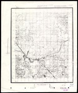
- Description:
- 1929
- Subject:
- Geographic Subject: Gorodnya, Topical Subject: Soviet Union, and Topical Subject: Maps
- Publisher:
- Военно-топографическое управление
- Language:
- Russian
- Identifier:
- VAC9619-003545
- Genre:
- Topographic Maps and Military Maps
- Geographic Location:
- Coordinates: 57.167, 31.25, 57.333, 31.5
- Related URL:
- Download GeoTIFF: https://drive.google.com/file/d/1FjmwidqkMb6yWwdQL_V2TgFIfjKpzItG/view?usp=sharing and Catalog URL: http://iucat.iu.edu/catalog/5020131
- Abstract:
- Modern area represented: Городня (Gorodnya), Novgorodskaya oblast, Russia
- Call Number:
- GM G7000 s50 .S68 sheet O-36-99-B
- Caption:
- Не подлежит оглашению and Captured map
- City:
- Городня (Gorodnya)
- Copyright Holder:
- No Copyright - United States
- Country:
- СССР (USSR)
- State/Province:
- Западная область (Western oblast), Ленинградская область (Leningrad oblast), and РСФСР (RSFSR)
- Physical Description:
- Scale: 1:50,000
- Persistent URL:
- http://purl.dlib.indiana.edu/iudl/images/VAC9619/VAC9619-003545
- Provenance:
- Army Map Service Library, OMAHA, Library of Congress Geography & Map Division
-
- Description:
- 1929
- Subject:
- Geographic Subject: Kamenka, Topical Subject: Soviet Union, and Topical Subject: Maps
- Publisher:
- Военно-топографическое управление
- Language:
- Russian
- Identifier:
- VAC9619-003544
- Genre:
- Topographic Maps and Military Maps
- Geographic Location:
- Coordinates: 57.167, 31, 57.333, 31.25
- Related URL:
- Download GeoTIFF: https://drive.google.com/file/d/1lmBNnLm3Poz1CI8n_BfSwm8NcQNlU4M-/view?usp=sharing and Catalog URL: http://iucat.iu.edu/catalog/5020131
- Abstract:
- Modern area represented: Каменка (Kamenka), Novgorodskaya oblast, Russia
- Call Number:
- GM G7000 s50 .S68 sheet O-36-99-A
- Caption:
- Не подлежит оглашению
- City:
- Каменка (Kamenka)
- Copyright Holder:
- No Copyright - United States
- Country:
- СССР (USSR)
- State/Province:
- РСФСР (RSFSR), Западная область (Western oblast), and Ленинградская область (Leningrad oblast)
- Physical Description:
- Scale: 1:50,000
- Persistent URL:
- http://purl.dlib.indiana.edu/iudl/images/VAC9619/VAC9619-003544
- Provenance:
- DMA Topographic Center, Army Map Service Library, Library of Congress Geography & Map Division
-
- Description:
- 1929
- Subject:
- Topical Subject: Maps, Topical Subject: Soviet Union, and Geographic Subject: Kakachevo
- Publisher:
- Военно-топографическое управление
- Language:
- Russian
- Identifier:
- VAC9619-003542
- Genre:
- Military Maps and Topographic Maps
- Geographic Location:
- Coordinates: 57.167, 30.75, 57.333, 31
- Related URL:
- Download GeoTIFF: https://drive.google.com/file/d/1YT8nZVeHKlhrNeoy8rtiqLf1NAd8Sj-v/view?usp=sharing and Catalog URL: http://iucat.iu.edu/catalog/5020131
- Abstract:
- Modern area represented: Какачево (Kakachevo), Novgorodskaya oblast, Russia
- Call Number:
- GM G7000 s50 .S68 sheet O-36-98-B
- Caption:
- Не подлежит оглашению and Captured map
- City:
- Какачево (Kakachevo)
- Copyright Holder:
- No Copyright - United States
- Country:
- СССР (USSR)
- State/Province:
- Западная область (Western oblast), РСФСР (RSFSR), and Ленинградская область (Leningrad oblast)
- Physical Description:
- Scale: 1:50,000
- Persistent URL:
- http://purl.dlib.indiana.edu/iudl/images/VAC9619/VAC9619-003542
- Provenance:
- Army Map Service Library, OMAHA, Library of Congress Geography & Map Division
-
- Description:
- 1929
- Subject:
- Topical Subject: Soviet Union, Geographic Subject: Ratcha, and Topical Subject: Maps
- Publisher:
- Военно-топографическое управление
- Language:
- Russian
- Identifier:
- VAC9619-003541
- Genre:
- Military Maps and Topographic Maps
- Geographic Location:
- Coordinates: 57.167, 30.5, 57.333, 30.75
- Related URL:
- Download GeoTIFF: https://drive.google.com/file/d/1pdcmxgXbZcHes0ODfezImWRALQDr-Qxg/view?usp=sharing and Catalog URL: http://iucat.iu.edu/catalog/5020131
- Abstract:
- Modern area represented: Ратча (Ratcha), Pskovskaya oblast, Russia
- Call Number:
- GM G7000 s50 .S68 sheet O-36-98-A
- Caption:
- Не подлежит оглашению and Captured map
- City:
- Ратча (Ratcha)
- Copyright Holder:
- No Copyright - United States
- Country:
- СССР (USSR)
- State/Province:
- РСФСР (RSFSR), Ленинградская область (Leningrad oblast), and Западная область (Western oblast)
- Physical Description:
- Scale: 1:50,000
- Persistent URL:
- http://purl.dlib.indiana.edu/iudl/images/VAC9619/VAC9619-003541
- Provenance:
- DMA Topographic Center, Army Map Service Library, OMAHA, Library of Congress Geography & Map Division
-
- Subject:
- Geographic Subject: Ukhoshino, Topical Subject: Maps, and Topical Subject: Soviet Union
- Publisher:
- Генеральный штаб РККА
- Language:
- Russian
- Identifier:
- VAC9619-003539
- Genre:
- Military Maps and Topographic Maps
- Geographic Location:
- Coordinates: 57.167, 30.25, 57.333, 30.5
- Related URL:
- Download GeoTIFF: https://drive.google.com/file/d/1nwuPTKsBeE-OS4plEajiLwXz3l9Vqea_/view?usp=sharing and Catalog URL: http://iucat.iu.edu/catalog/5020131
- Abstract:
- Modern area represented: Ухошино (Ukhoshino), Pskovskaya oblast, Russia
- Call Number:
- GM G7000 s50 .S68 sheet O-36-97-B
- Caption:
- Не подлежит оглашению and Captured map
- City:
- Ухошино (Ukhoshino)
- Copyright Holder:
- No Copyright - United States
- Country:
- СССР (USSR)
- State/Province:
- РСФСР (RSFSR), Калининская область (Kalinin oblast), and Ленинградская область (Leningrad oblast)
- Physical Description:
- Scale: 1:50,000
- Persistent URL:
- http://purl.dlib.indiana.edu/iudl/images/VAC9619/VAC9619-003539
- Provenance:
- Army Map Service Library, OMAHA, Library of Congress Geography & Map Division
-
- Description:
- 1926
- Subject:
- Geographic Subject: Novoye, Topical Subject: Soviet Union, and Topical Subject: Maps
- Publisher:
- Управление военных топографов РККА
- Language:
- Russian
- Identifier:
- VAC9619-003538
- Genre:
- Topographic Maps and Military Maps
- Geographic Location:
- Coordinates: 57.167, 30, 57.333, 30.25
- Related URL:
- Download GeoTIFF: https://drive.google.com/file/d/1_ZgjN1E6psP0P6hvxP2ZANr3zbym9FI2/view?usp=sharing and Catalog URL: http://iucat.iu.edu/catalog/5020131
- Abstract:
- Modern area represented: Новое (Novoye), Pskovskaya oblast, Russia
- Call Number:
- GM G7000 s50 .S68 sheet O-36-97-A
- Caption:
- Не подлежит оглашению
- City:
- Пог. Новое (Novoye)
- Copyright Holder:
- No Copyright - United States
- Country:
- СССР (USSR)
- State/Province:
- Ленинградская область (Leningrad oblast), РСФСР (RSFSR), and Калининская область (Kalinin oblast)
- Physical Description:
- Scale: 1:50,000
- Persistent URL:
- http://purl.dlib.indiana.edu/iudl/images/VAC9619/VAC9619-003538
- Provenance:
- Army Map Service Library, OMAHA, Library of Congress Geography & Map Division
-
- Description:
- 1938
- Subject:
- Geographic Subject: Vyshitino, Topical Subject: Soviet Union, and Topical Subject: Maps
- Publisher:
- Главное управление государственной съемки и картографии НКВД СССР
- Language:
- Russian
- Identifier:
- VAC9619-003534
- Genre:
- Topographic Maps and Military Maps
- Geographic Location:
- Coordinates: 57.3333, 31.75, 57.5, 32.0
- Related URL:
- Catalog URL: http://iucat.iu.edu/catalog/5020131 and Download GeoTIFF: https://drive.google.com/file/d/15fYzUgb8nygu04vteSGvdZHPizVqeb0h/view?usp=sharing
- Abstract:
- Modern area represented: Вышитино (Vyshitino), Novgorodskaya oblast, Russia
- Call Number:
- GM G7000 s50 .S68 sheet O-36-88-D
- Caption:
- Captured map
- City:
- Вышитино (Vyshitino)
- Copyright Holder:
- No Copyright - United States
- Country:
- СССР (USSR)
- State/Province:
- Ленинградская область (Leningrad oblast), Молвотицкий район (Molvotitsky district), and Залучский район (Zaluchsky district)
- Physical Description:
- Scale: 1:50,000
- Persistent URL:
- http://purl.dlib.indiana.edu/iudl/images/VAC9619/VAC9619-003534
- Provenance:
- DMA Topographic Center, Army Map Service Library, OMAHA, Library of Congress Geography & Map Division
-
- Description:
- 1932
- Subject:
- Topical Subject: Maps, Topical Subject: Soviet Union, and Geographic Subject: Poddor'ye
- Publisher:
- Управление военных топографов
- Language:
- Russian
- Identifier:
- VAC9619-003533
- Genre:
- Military Maps and Topographic Maps
- Geographic Location:
- Coordinates: 57.3333, 31.0, 57.5, 31.25
- Related URL:
- Catalog URL: http://iucat.iu.edu/catalog/5020131 and Download GeoTIFF: https://drive.google.com/file/d/1iAyFR8ALMrmCoXPjaR-QZRBpVdP8BLku/view?usp=sharing
- Abstract:
- Modern area represented: Поддорье (Poddor'ye), Novgorodskaya oblast, Russia
- Call Number:
- GM G7000 s50 .S68 sheet O-36-87-C
- Caption:
- Не подлежит оглашению
- City:
- Поддорье (Poddor'ye)
- Copyright Holder:
- No Copyright - United States
- Country:
- СССР (USSR)
- State/Province:
- РСФСР (RSFSR) and Ленинградская область (Leningrad oblast)
- Physical Description:
- Scale: 1:50,000
- Persistent URL:
- http://purl.dlib.indiana.edu/iudl/images/VAC9619/VAC9619-003533
- Provenance:
- DMA Topographic Center, Army Map Service Library, OMAHA, Library of Congress Geography & Map Division
-
- Description:
- 1932
- Subject:
- Topical Subject: Soviet Union, Geographic Subject: Rakhlitsy, and Topical Subject: Maps
- Publisher:
- Управление военных топографов
- Language:
- Russian
- Identifier:
- VAC9619-003532
- Genre:
- Topographic Maps and Military Maps
- Geographic Location:
- Coordinates: 57.5, 31.25, 57.6667, 31.5
- Related URL:
- Download GeoTIFF: https://drive.google.com/file/d/1o_K2Up3S5K7jhomjmsZpP78iQtThrVry/view?usp=sharing and Catalog URL: http://iucat.iu.edu/catalog/5020131
- Abstract:
- Modern area represented: Рахлицы (Rakhlitsy), Novgorodskaya oblast, Russia
- Call Number:
- GM G7000 s50 .S68 sheet O-36-87-B
- Caption:
- Не подлежит оглашению
- City:
- Рахлицы (Rakhlitsy)
- Copyright Holder:
- No Copyright - United States
- Country:
- СССР (USSR)
- State/Province:
- Ленинградская область (Leningrad oblast) and РСФСР (RSFSR)
- Physical Description:
- Scale: 1:50,000
- Persistent URL:
- http://purl.dlib.indiana.edu/iudl/images/VAC9619/VAC9619-003532
- Provenance:
- DMA Topographic Center, Army Map Service Library, OMAHA, Library of Congress Geography & Map Division
-
- Description:
- 1932
- Subject:
- Topical Subject: Soviet Union, Geographic Subject: Goyki, and Topical Subject: Maps
- Publisher:
- Управление военных топографов
- Language:
- Russian
- Identifier:
- VAC9619-003531
- Genre:
- Topographic Maps and Military Maps
- Geographic Location:
- Coordinates: 57.3333, 30.75, 57.5, 31.0
- Related URL:
- Download GeoTIFF: https://drive.google.com/file/d/1v2e3AE09NzWxXhhJ58KQ-Aor-a3vr-NW/view?usp=sharing and Catalog URL: http://iucat.iu.edu/catalog/5020131
- Abstract:
- Modern area represented: Гойки (Goyki), Novgorodskaya oblast, Russia
- Call Number:
- GM G7000 s50 .S68 sheet O-36-86-D
- Caption:
- Не подлежит оглашению
- City:
- Гойки (Goyki)
- Copyright Holder:
- No Copyright - United States
- Country:
- СССР (USSR)
- State/Province:
- РСФСР (RSFSR) and Ленинградская область (Leningrad oblast)
- Physical Description:
- Scale: 1:50,000
- Persistent URL:
- http://purl.dlib.indiana.edu/iudl/images/VAC9619/VAC9619-003531
- Provenance:
- Army Map Service Library, OMAHA, Library of Congress Geography & Map Division
-
- Description:
- 1932
- Subject:
- Topical Subject: Soviet Union, Topical Subject: Maps, and Geographic Subject: Zapol'ye
- Publisher:
- Управление военных топографов
- Language:
- Russian
- Date Created:
- 1935
- Identifier:
- VAC9619-003530
- Genre:
- Topographic Maps and Military Maps
- Geographic Location:
- Coordinates: 57.3333, 30.5, 57.5, 30.75
- Related URL:
- Download GeoTIFF: https://drive.google.com/file/d/1abqgMUIx4YwMEuwFrohfNLhOCdIr0eph/view?usp=sharing and Catalog URL: http://iucat.iu.edu/catalog/5020131
- Abstract:
- Modern area represented: Заполье (Zapol'ye), Novgorodskaya oblast, Russia
- Call Number:
- GM G7000 s50 .S68 sheet O-36-86-C
- Caption:
- Для служебного пользования and Captured map
- City:
- Заполье (Zapol'ye)
- Copyright Holder:
- No Copyright - United States
- Country:
- СССР (USSR)
- State/Province:
- РСФСР (RSFSR) and Ленинградская область (Leningrad oblast)
- Physical Description:
- Scale: 1:50,000
- Persistent URL:
- http://purl.dlib.indiana.edu/iudl/images/VAC9619/VAC9619-003530
- Provenance:
- DMA Topographic Center, Army Map Service Library, OMAHA, Library of Congress Geography & Map Division
-
- Description:
- 1932
- Subject:
- Topical Subject: Maps, Topical Subject: Soviet Union, and Geographic Subject: Belebelka
- Publisher:
- Управление военных топографов
- Language:
- Russian
- Date Created:
- 1935
- Identifier:
- VAC9619-003529
- Genre:
- Military Maps and Topographic Maps
- Geographic Location:
- Coordinates: 57.5, 30.75, 57.6667, 31.0
- Related URL:
- Download GeoTIFF: https://drive.google.com/file/d/1MsF7NM8_S3piH2IIQADcekLjZ5KjdXss/view?usp=sharing and Catalog URL: http://iucat.iu.edu/catalog/5020131
- Abstract:
- Modern area represented: Белебелка (Belebelka), Novgorodskaya oblast, Russia
- Call Number:
- GM G7000 s50 .S68 sheet O-36-86-B
- Caption:
- Captured map and Не подлежит оглашению
- City:
- Белебелка (Belebelka)
- Copyright Holder:
- No Copyright - United States
- Country:
- СССР (USSR)
- State/Province:
- РСФСР (RSFSR) and Ленинградская область (Leningrad oblast)
- Physical Description:
- Scale: 1:50,000
- Persistent URL:
- http://purl.dlib.indiana.edu/iudl/images/VAC9619/VAC9619-003529
- Provenance:
- DMA Topographic Center, Army Map Service Library, OMAHA, Library of Congress Geography & Map Division
-
- Description:
- 1932
- Subject:
- Topical Subject: Soviet Union, Topical Subject: Maps, and Geographic Subject: Parevichi
- Publisher:
- Управление военных топографов
- Language:
- Russian
- Date Created:
- 1935
- Identifier:
- VAC9619-003528
- Genre:
- Topographic Maps and Military Maps
- Geographic Location:
- Coordinates: 57.3333, 30.25, 57.5, 30.5
- Related URL:
- Download GeoTIFF: https://drive.google.com/file/d/1XoJ_B73bclp0wAy4LtwTrHbzPBWOIEMp/view?usp=sharing and Catalog URL: http://iucat.iu.edu/catalog/5020131
- Abstract:
- Modern area represented: Паревичи (Parevichi), Pskovskaya oblast, Russia
- Call Number:
- GM G7000 s50 .S68 sheet O-36-85-D
- Caption:
- Не подлежит оглашению
- City:
- Паревичи (Parevichi)
- Copyright Holder:
- No Copyright - United States
- Country:
- СССР (USSR)
- State/Province:
- Ленинградская область (Leningrad oblast) and РСФСР (RSFSR)
- Physical Description:
- Scale: 1:50,000
- Persistent URL:
- http://purl.dlib.indiana.edu/iudl/images/VAC9619/VAC9619-003528
- Provenance:
- Army Map Service Library, OMAHA, Library of Congress Geography & Map Division
-
- Description:
- 1932
- Subject:
- Topical Subject: Soviet Union, Topical Subject: Maps, and Geographic Subject: Sosnitsa
- Publisher:
- Управление военных топографов
- Language:
- Russian
- Identifier:
- VAC9619-003527
- Genre:
- Topographic Maps and Military Maps
- Geographic Location:
- Coordinates: 57.5, 30.25, 57.66667, 30.5
- Related URL:
- Download GeoTIFF: https://drive.google.com/file/d/1otfh7tEJGovjTG1kBgOUSPykGF2A9kj3/view?usp=sharing and Catalog URL: http://iucat.iu.edu/catalog/5020131
- Abstract:
- Modern area represented: Сосница (Sosnitsa), Pskovskaya oblast, Russia
- Call Number:
- GM G7000 s50 .S68 sheet O-36-85-B
- Caption:
- Не подлежит оглашению and Captured map
- City:
- Сосницы (Sosnitsy)
- Copyright Holder:
- No Copyright - United States
- Country:
- СССР (USSR)
- State/Province:
- Ленинградская область (Leningrad oblast) and РСФСР (RSFSR)
- Physical Description:
- Scale: 1:50,000
- Persistent URL:
- http://purl.dlib.indiana.edu/iudl/images/VAC9619/VAC9619-003527
- Provenance:
- Army Map Service Library, OMAHA
-
- Description:
- 1924
- Subject:
- Topical Subject: Maps, Topical Subject: Soviet Union, and Geographic Subject: Bologoye
- Publisher:
- Главное геодезическое управление
- Language:
- Russian
- Identifier:
- VAC9619-003526
- Genre:
- Military Maps and Topographic Maps
- Geographic Location:
- Coordinates: 57.83333, 34.0, 58.0, 34.25
- Related URL:
- Download GeoTIFF: https://drive.google.com/file/d/1lKo1upa-fCEH_6HHmrxRE5MEUJX84ipc/view?usp=sharing and Catalog URL: http://iucat.iu.edu/catalog/5020131
- Abstract:
- Modern area represented: Бологое (Bologoye), Tverskaya oblast, Russia
- Call Number:
- GM G7000 s50 .S68 sheet O-36-81-A
- Caption:
- Не подлежит оглашению
- City:
- Бологое (Bologoye)
- Copyright Holder:
- No Copyright - United States
- Country:
- СССР (USSR)
- State/Province:
- РСФСР (RSFSR) and Ленинградская область (Leningrad oblast)
- Physical Description:
- Scale: 1:50,000
- Persistent URL:
- http://purl.dlib.indiana.edu/iudl/images/VAC9619/VAC9619-003526
- Provenance:
- CIA Map Library
-

- Description:
- 1938
- Subject:
- Geographic Subject: Nalyuchi, Topical Subject: Soviet Union, and Topical Subject: Maps
- Publisher:
- Главное управление геодезии и картографии при СНК СССР
- Language:
- Russian
- Date Created:
- 1940
- Identifier:
- VAC9619-003525
- Genre:
- Military Maps and Topographic Maps
- Geographic Location:
- Coordinates: 57.66667, 31.75, 57.83333, 32.0
- Related URL:
- Download GeoTIFF: https://drive.google.com/file/d/1sFselxWPujPodWUqJlqPIV8m91n3gL0P/view?usp=sharing and Catalog URL: http://iucat.iu.edu/catalog/5020131
- Abstract:
- Modern area represented: Налючи (Nalyuchi), Novgorodskaya oblast, Russia
- Call Number:
- GM G7000 s50 .S68 sheet O-36-76-D
- Caption:
- Для служебного пользования
- City:
- Налючи (Nalyuchi)
- Copyright Holder:
- No Copyright - United States
- Country:
- СССР (USSR)
- State/Province:
- Лычковский район (Lychkovsky district), Старорусский район (Starorussky district), Демянский район (Demyansky district), Ленинградская область (Leningrad obl...
- Physical Description:
- Scale: 1:50,000
- Persistent URL:
- http://purl.dlib.indiana.edu/iudl/images/VAC9619/VAC9619-003525
- Provenance:
- DMA Topographic Center, Army Map Service Library, OMAHA, Library of Congress Geography & Map Division
-
- Description:
- 1932
- Subject:
- Topical Subject: Maps, Geographic Subject: Vidzha, and Topical Subject: Soviet Union
- Publisher:
- Управление военных топографов
- Language:
- Russian
- Identifier:
- VAC9619-003524
- Genre:
- Military Maps and Topographic Maps
- Geographic Location:
- Coordinates: 57.66667, 31.0, 57.83333, 31.25
- Related URL:
- Download GeoTIFF: https://drive.google.com/file/d/1HLU6T17I6ZF-MnPAtxH0sQA-VXBqJxji/view?usp=sharing and Catalog URL: http://iucat.iu.edu/catalog/5020131
- Abstract:
- Modern area represented: Виджа (Vidzha), Novgorodskaya oblast, Russia
- Call Number:
- GM G7000 s50 .S68 sheet O-36-75-C
- Caption:
- Не подлежит оглашению and Captured map
- City:
- Виджа (Vidzha)
- Copyright Holder:
- No Copyright - United States
- Country:
- СССР (USSR)
- State/Province:
- Ленинградская область (Leningrad oblast) and РСФСР (RSFSR)
- Physical Description:
- Scale: 1:50,000
- Persistent URL:
- http://purl.dlib.indiana.edu/iudl/images/VAC9619/VAC9619-003524
- Provenance:
- DMA Topographic Center, Army Map Service Library, OMAHA, Library of Congress Geography & Map Division
-
- Description:
- 1939
- Subject:
- Geographic Subject: Druzhnaya Gorka, Topical Subject: Maps, and Topical Subject: Soviet Union
- Publisher:
- Главное управление геодезии и картографии при СНК СССР
- Language:
- Russian
- Identifier:
- VAC9619-003376
- Genre:
- Topographic Maps and Military Maps
- Geographic Location:
- Coordinates: 58.333, 32.75, 58.5, 33
- Related URL:
- Catalog URL: http://iucat.iu.edu/catalog/5020131 and Download GeoTIFF: https://drive.google.com/file/d/1oGUheQvOXuuLP8IOCN-VUvVMS9T4NRqK/view?usp=sharing
- Abstract:
- Modern area represented: Дружная Горка (Druzhnaya Gorka), Novgorodskaya oblast, Russia
- Call Number:
- G7000 s50 .S68 sheet O-36-54-D
- Caption:
- Для служебного пользования
- City:
- Glupaya Gorka
- Copyright Holder:
- No Copyright - United States
- Country:
- СССР (USSR)
- State/Province:
- Ленинградская область (Leningrad oblast), Окуловский район (Okulovsky district), and Крестецкий район (Krestetsky district)
- Physical Description:
- Scale: 1:50,000
- Persistent URL:
- http://purl.dlib.indiana.edu/iudl/images/VAC9619/VAC9619-003376
- Provenance:
- DMA Topographic Center, Army Map Service Library, OMAHA, Library of Congress Geography & Map Division
-
- Description:
- 1938
- Subject:
- Topical Subject: Soviet Union, Topical Subject: Maps, and Geographic Subject: Budki
- Publisher:
- Главное управление геодезии и картографии при СНК СССР
- Language:
- Russian
- Date Created:
- 1940
- Identifier:
- VAC9619-003375
- Genre:
- Topographic Maps and Military Maps
- Geographic Location:
- Coordinates: 58.333, 32.5, 58.5, 32.75
- Related URL:
- Download GeoTIFF: https://drive.google.com/file/d/1so-14PckiQLb0Gwdnqcm2d8t0g5cumQ-/view?usp=sharing and Catalog URL: http://iucat.iu.edu/catalog/5020131
- Abstract:
- Modern area represented: Будки (Budki), Novgorodskaya oblast, Russia
- Call Number:
- G7000 s50 .S68 sheet O-36-54-C
- Caption:
- Для служебного пользования
- City:
- Будки (Budki)
- Copyright Holder:
- No Copyright - United States
- Country:
- СССР (USSR)
- State/Province:
- Маловишерский район (Malovishersky district), Крестецкий район (Krestetsky district), Ленинградская область (Leningrad oblast), and Окуловский район (Okulovs...
- Physical Description:
- Scale: 1:50,000
- Persistent URL:
- http://purl.dlib.indiana.edu/iudl/images/VAC9619/VAC9619-003375
- Provenance:
- DMA Topographic Center, Army Map Service Library, Library of Congress Geography & Map Division
-
- Description:
- 1939
- Subject:
- Topical Subject: Maps, Geographic Subject: Torbino, and Topical Subject: Soviet Union
- Publisher:
- Главное управление геодезии и картографии при СНК СССР
- Language:
- Russian
- Date Created:
- 1941
- Identifier:
- VAC9619-003374
- Genre:
- Military Maps and Topographic Maps
- Geographic Location:
- Coordinates: 58.5, 32.75, 58.667, 33
- Related URL:
- Download GeoTIFF: https://drive.google.com/file/d/1REcpv4d51hjjI3DlbpCjUEu2PCsUgHsu/view?usp=sharing and Catalog URL: http://iucat.iu.edu/catalog/5020131
- Abstract:
- Modern area represented: Торбино (Torbino), Novgorodskaya oblast, Russia
- Call Number:
- G7000 s50 .S68 sheet O-36-54-B
- Caption:
- Для служебного пользования and Captured map
- City:
- Торбино (Torbino)
- Copyright Holder:
- No Copyright - United States
- Country:
- СССР (USSR)
- State/Province:
- Ленинградская область (Leningrad oblast)
- Physical Description:
- Scale: 1:50,000
- Persistent URL:
- http://purl.dlib.indiana.edu/iudl/images/VAC9619/VAC9619-003374
- Provenance:
- DMA Topographic Center, Army Map Service Library, OMAHA, Library of Congress Geography & Map Division
