
Search Constraints
You searched for:
Campus
IUB
Remove constraint Campus: IUB
Country
Германия (Germany)
Remove constraint Country: Германия (Germany)
Date Created
1940
Remove constraint Date Created: 1940
Type
Image
Remove constraint Type: Image
« Previous |
1 - 50 of 101
|
Next »
Search Results
-
- Description:
- 1881
- Subject:
- Topical Subject: Maps, Geographic Subject: Bytom, and Topical Subject: Soviet Union
- Publisher:
- Генеральный штаб Красной Армии
- Language:
- Russian
- Date Created:
- 1940
- Identifier:
- VAC9619-004221
- Genre:
- Topographic Maps and Military Maps
- Geographic Location:
- Coordinates: 50.33333, 18.5, 50.66667, 19.0
- Related URL:
- Catalog URL: https://iucat.iu.edu/catalog/5020129 and Download GeoTIFF: https://drive.google.com/file/d/1ECBUIcdumZkVhUYVW1ciTwpzQrNkm8dg/view?usp=sharing
- Abstract:
- Modern area represented: Bytom, Silesia, Poland
- Call Number:
- G7000 s100 .S7 sheet M-34-50
- City:
- Беутен (Beuthen)
- Copyright Holder:
- No Copyright - United States
- Country:
- Германия (Germany)
- State/Province:
- Область государственных интересов Германии (Region of German state interests)
- Physical Description:
- Scale: 1:100,000
- Persistent URL:
- http://purl.dlib.indiana.edu/iudl/images/VAC9619/VAC9619-004221
- Provenance:
- DMA Topographic Center, Auswärtiges Amt. Geographischer Dienst, OMAHA, Army Map Service Library
-
- Description:
- 1891
- Subject:
- Topical Subject: Maps, Topical Subject: Soviet Union, and Geographic Subject: Strzelno
- Publisher:
- Генеральный штаб Красной Армии
- Language:
- Russian
- Date Created:
- 1940
- Identifier:
- VAC9619-003985
- Genre:
- Military Maps and Topographic Maps
- Geographic Location:
- Coordinates: 52.333, 18, 52.667, 18.5
- Related URL:
- Download GeoTIFF: https://drive.google.com/file/d/15hCXZi0c_oWDoRLPMoA-LUfwXnHNk3DI/view?usp=sharing and Catalog URL: https://iucat.iu.edu/catalog/5020129
- Abstract:
- Modern area represented: Strzelno, Kuyavian-Pomeranian Voivodeship, Poland
- Call Number:
- G7000 s100 .S7 sheet N-34-121
- City:
- Стшельно (Strzelno)
- Copyright Holder:
- No Copyright - United States
- Country:
- Германия (Germany)
- State/Province:
- Область государственных интересов Германии (Region of German state interests)
- Physical Description:
- Scale: 1:100,000
- Persistent URL:
- http://purl.dlib.indiana.edu/iudl/images/VAC9619/VAC9619-003985
- Provenance:
- DMA Topographic Center, Army Map Service Library, OMAHA
-
- Description:
- 1924
- Subject:
- Geographic Subject: Inowroclaw, Topical Subject: Soviet Union, and Topical Subject: Maps
- Publisher:
- Генеральный штаб РККА
- Language:
- Russian
- Date Created:
- 1940
- Identifier:
- VAC9619-003974
- Genre:
- Military Maps and Topographic Maps
- Geographic Location:
- Coordinates: 52.667, 18, 53, 18.5
- Related URL:
- Catalog URL: https://iucat.iu.edu/catalog/5020129 and Download GeoTIFF: https://drive.google.com/file/d/1wretOfm4Ek7X9aIbeZAfJ7WbxN6jJ09r/view?usp=sharing
- Abstract:
- Modern area represented: Inowroclaw, Kuyavian-Pomeranian Voivodeship, Poland
- Call Number:
- G7000 s100 .S7 sheet N-34-109
- City:
- Иновроцлав (Inowroclaw)
- Copyright Holder:
- No Copyright - United States
- Country:
- Германия (Germany)
- State/Province:
- Область государственных интересов Германии (Region of German state interests)
- Physical Description:
- Scale: 1:100,000
- Persistent URL:
- http://purl.dlib.indiana.edu/iudl/images/VAC9619/VAC9619-003974
- Provenance:
- DMA Topographic Center, Army Map Service Library, OMAHA
-
- Description:
- 1924
- Subject:
- Topical Subject: Soviet Union, Topical Subject: Maps, and Geographic Subject: Toruń
- Publisher:
- Генеральный штаб Красной Армии
- Language:
- Russian
- Date Created:
- 1940
- Identifier:
- VAC9619-003964
- Genre:
- Military Maps and Topographic Maps
- Geographic Location:
- Coordinates: 53, 18.5, 53.333, 19
- Related URL:
- Download GeoTIFF: https://drive.google.com/file/d/1JcRCYg0ag1jhz42kgoDL2EfF8cA63V7a/view?usp=sharing and Catalog URL: https://iucat.iu.edu/catalog/5020129
- Abstract:
- Modern area represented: Toruń, Kujawsko-Pomorskie, Poland
- Call Number:
- G7000 s100 .S7 sheet N-34-98
- City:
- Торн (Torn)
- Copyright Holder:
- No Copyright - United States
- Country:
- Германия (Germany)
- State/Province:
- Область государственных интересов Германии (Region of German state interests)
- Physical Description:
- Scale: 1:100,000
- Persistent URL:
- http://purl.dlib.indiana.edu/iudl/images/VAC9619/VAC9619-003964
- Provenance:
- DMA Topographic Center, Army Map Service Library
-
- Description:
- 1909
- Subject:
- Geographic Subject: Bydgoszcz, Topical Subject: Maps, and Topical Subject: Soviet Union
- Publisher:
- Генеральный штаб Красной Армии
- Language:
- Russian
- Date Created:
- 1940
- Identifier:
- VAC9619-003963
- Genre:
- Military Maps and Topographic Maps
- Geographic Location:
- Coordinates: 53, 18, 53.333, 18.5
- Related URL:
- Download GeoTIFF: https://drive.google.com/file/d/1QFcmG8Ti1Ca8ljP7-hvkvJ7VDmebiaSs/view?usp=sharing and Catalog URL: https://iucat.iu.edu/catalog/5020129
- Abstract:
- Modern area represented: Bydgoszcz, Kujawsko-Pomorskie, Poland
- Call Number:
- G7000 s100 .S7 sheet N-34-97
- City:
- Бромберг (Bromberg)
- Copyright Holder:
- No Copyright - United States
- Country:
- Германия (Germany)
- Physical Description:
- Scale: 1:100,000
- Persistent URL:
- http://purl.dlib.indiana.edu/iudl/images/VAC9619/VAC9619-003963
- Provenance:
- DMA Topographic Center, Army Map Service Library, OMAHA
-
- Description:
- 1918
- Subject:
- Topical Subject: Maps, Geographic Subject: Grudziądz, and Topical Subject: Soviet Union
- Publisher:
- Генеральный штаб Красной Армии
- Language:
- Russian
- Date Created:
- 1940
- Identifier:
- VAC9619-003953
- Genre:
- Topographic Maps and Military Maps
- Geographic Location:
- Coordinates: 53.333, 18.5, 53.667, 19
- Related URL:
- Download GeoTIFF: https://drive.google.com/file/d/1NC9gReVruuq5hmkMnfi6Ol-99YjmP1A-/view?usp=sharing and Catalog URL: https://iucat.iu.edu/catalog/5020129
- Abstract:
- Modern area represented: Grudziądz, Kujawsko-Pomorskie, Poland
- Call Number:
- G7000 s100 .S7 sheet N-34-86
- City:
- Грауденц (Graudenz)
- Copyright Holder:
- No Copyright - United States
- Country:
- Германия (Germany)
- Physical Description:
- Scale: 1:100,000
- Persistent URL:
- http://purl.dlib.indiana.edu/iudl/images/VAC9619/VAC9619-003953
- Provenance:
- DMA Topographic Center, Army Map Service Library, OMAHA
-
- Description:
- 1924
- Subject:
- Topical Subject: Soviet Union, Geographic Subject: Chełmno, and Topical Subject: Maps
- Publisher:
- Генеральный штаб Красной Армии
- Language:
- Russian
- Date Created:
- 1940
- Identifier:
- VAC9619-003952
- Genre:
- Military Maps and Topographic Maps
- Geographic Location:
- Coordinates: 53.333, 18, 53.667, 18.5
- Related URL:
- Download GeoTIFF: https://drive.google.com/file/d/1NSqvdlGKH54QrEQZf4fNSE9JC-SRrzMx/view?usp=sharing and Catalog URL: https://iucat.iu.edu/catalog/5020129
- Abstract:
- Modern area represented: Chełmno, Kujawsko-Pomorskie, Poland
- Call Number:
- G7000 s100 .S7 sheet N-34-85
- City:
- Кульм (Kulm)
- Copyright Holder:
- No Copyright - United States
- Country:
- Германия (Germany)
- Physical Description:
- Scale: 1:100,000
- Persistent URL:
- http://purl.dlib.indiana.edu/iudl/images/VAC9619/VAC9619-003952
- Provenance:
- DMA Topographic Center, Army Map Service Library
-
- Description:
- 1906
- Subject:
- Geographic Subject: Kwidzyn, Topical Subject: Maps, and Topical Subject: Soviet Union
- Publisher:
- Генеральный штаб Красной Армии
- Language:
- Russian
- Date Created:
- 1940
- Identifier:
- VAC9619-003942
- Genre:
- Military Maps and Topographic Maps
- Geographic Location:
- Coordinates: 53.667, 18.5, 54, 19
- Related URL:
- Catalog URL: https://iucat.iu.edu/catalog/5020129 and Download GeoTIFF: https://drive.google.com/file/d/1-5kDJDDNJLlI47BNm9MrRQ7Mg5I3rMnI/view?usp=sharing
- Abstract:
- Modern area represented: Kwidzyn, Pomeranian voivodeship, Poland
- Call Number:
- G7000 s100 .S7 sheet N-34-74
- City:
- Мариенвердер (Marienwerder)
- Copyright Holder:
- No Copyright - United States
- Country:
- Германия (Germany)
- Physical Description:
- Scale: 1:100,000
- Persistent URL:
- http://purl.dlib.indiana.edu/iudl/images/VAC9619/VAC9619-003942
- Provenance:
- DMA Topographic Center, Army Map Service Library
-
- Description:
- 1889
- Subject:
- Geographic Subject: Sejny, Topical Subject: Maps, and Topical Subject: Soviet Union
- Publisher:
- Генеральный штаб Красной Армии
- Language:
- Russian
- Date Created:
- 1940
- Identifier:
- VAC9619-003939
- Genre:
- Topographic Maps and Military Maps
- Geographic Location:
- Coordinates: 54, 23, 54.333, 23.5
- Related URL:
- Catalog URL: https://iucat.iu.edu/catalog/5020129 and Download GeoTIFF: https://drive.google.com/file/d/19quAe16lOCpYTJJ95LylZkahDZQVaXl1/view?usp=sharing
- Abstract:
- Modern area represented: Sejny, Podlaskie voivodeship, Poland
- Call Number:
- G7000 s100 .S7 sheet N-34-71
- Caption:
- Для служебного пользования
- City:
- Сейны (Sejny)
- Copyright Holder:
- No Copyright - United States
- Country:
- Германия (Germany)
- State/Province:
- Область государственных интересов Германии (Region of German state interests) and Литовская ССР (Lithuanian Soviet Socialist Republic)
- Physical Description:
- Scale: 1:100,000
- Persistent URL:
- http://purl.dlib.indiana.edu/iudl/images/VAC9619/VAC9619-003939
- Provenance:
- DMA Topographic Center, Army Map Service Library, OMAHA
-
- Description:
- 1925
- Subject:
- Topical Subject: Maps, Geographic Subject: Tczew, and Topical Subject: Soviet Union
- Publisher:
- Генеральный штаб Красной Армии
- Language:
- Russian
- Date Created:
- 1940
- Identifier:
- VAC9619-003931
- Genre:
- Military Maps and Topographic Maps
- Geographic Location:
- Coordinates: 54, 18.5, 54.333, 19
- Related URL:
- Download GeoTIFF: https://drive.google.com/file/d/1wmiOysBOQ7SxeeFdFDA7blujWD0900wC/view?usp=sharing and Catalog URL: https://iucat.iu.edu/catalog/5020129
- Abstract:
- Modern area represented: Tczew, Pomerania, Poland
- Call Number:
- G7000 s100 .S7 sheet N-34-62
- City:
- Диршау (Dirschau)
- Copyright Holder:
- No Copyright - United States
- Country:
- Германия (Germany)
- Physical Description:
- Scale: 1:100,000
- Persistent URL:
- http://purl.dlib.indiana.edu/iudl/images/VAC9619/VAC9619-003931
- Provenance:
- DMA Topographic Center, Army Map Service Library, OMAHA
-
- Description:
- 1925
- Subject:
- Topical Subject: Soviet Union, Geographic Subject: Skarszewy, and Topical Subject: Maps
- Publisher:
- Генеральный штаб Красной Армии
- Language:
- Russian
- Date Created:
- 1940
- Identifier:
- VAC9619-003930
- Genre:
- Topographic Maps and Military Maps
- Geographic Location:
- Coordinates: 54, 18, 54.333, 18.5
- Related URL:
- Catalog URL: https://iucat.iu.edu/catalog/5020129 and Download GeoTIFF: https://drive.google.com/file/d/1mCfUViGAZRTBWeMnSq6MhXHT7gTXeXp0/view?usp=sharing
- Abstract:
- Modern area represented: Skarszewy, Pomeranian Voivodeship, Poland
- Call Number:
- G7000 s100 .S7 sheet N-34-61
- City:
- Шёнек (Schöneck)
- Copyright Holder:
- No Copyright - United States
- Country:
- Германия (Germany)
- Physical Description:
- Scale: 1:100,000
- Persistent URL:
- http://purl.dlib.indiana.edu/iudl/images/VAC9619/VAC9619-003930
- Provenance:
- DMA Topographic Center, Army Map Service Library
-
- Description:
- 1908
- Subject:
- Geographic Subject: Gdańsk, Topical Subject: Soviet Union, and Topical Subject: Maps
- Publisher:
- Генеральный штаб Красной Армии
- Language:
- Russian
- Date Created:
- 1940
- Identifier:
- VAC9619-003919
- Genre:
- Military Maps and Topographic Maps
- Geographic Location:
- Coordinates: 54.333, 18.5, 54.667, 19
- Related URL:
- Catalog URL: https://iucat.iu.edu/catalog/5020129 and Download GeoTIFF: https://drive.google.com/file/d/1QqquaMOzje6XUIDNkG-TS6bxXKRpANbw/view?usp=sharing
- Abstract:
- Modern area represented: Gdańsk, Pomerania, Poland
- Call Number:
- G7000 s100 .S7 sheet N-34-50
- City:
- Данциг (Danzig)
- Copyright Holder:
- No Copyright - United States
- Country:
- Германия (Germany)
- Physical Description:
- Scale: 1:100,000
- Persistent URL:
- http://purl.dlib.indiana.edu/iudl/images/VAC9619/VAC9619-003919
- Provenance:
- DMA Topographic Center, Army Map Service Library, OMAHA
-
- Description:
- 1928
- Subject:
- Topical Subject: Maps, Geographic Subject: Neustadt, and Topical Subject: Soviet Union
- Publisher:
- Генеральный штаб Красной Армии
- Language:
- Russian
- Date Created:
- 1940
- Identifier:
- VAC9619-003918
- Genre:
- Topographic Maps and Military Maps
- Geographic Location:
- Coordinates: 54.333, 18, 54.667, 18.5
- Related URL:
- Catalog URL: https://iucat.iu.edu/catalog/5020129 and Download GeoTIFF: https://drive.google.com/file/d/1QRW-an_IjgASFp8OzHEeAlKwGaXPJgou/view?usp=sharing
- Abstract:
- Modern area represented: Neustadt, Germany
- Call Number:
- G7000 s100 .S7 sheet N-34-49
- City:
- Нойштадт (Neustadt)
- Copyright Holder:
- No Copyright - United States
- Country:
- Германия (Germany)
- Physical Description:
- Scale: 1:100,000
- Persistent URL:
- http://purl.dlib.indiana.edu/iudl/images/VAC9619/VAC9619-003918
- Provenance:
- DMA Topographic Center, Army Map Service Library
-
- Description:
- 1913
- Subject:
- Geographic Subject: Kudirkos Naumiestis, Topical Subject: Maps, and Topical Subject: Soviet Union
- Publisher:
- Генеральный штаб Красной Армии
- Language:
- Russian
- Date Created:
- 1940
- Identifier:
- VAC9619-003915
- Genre:
- Topographic Maps and Military Maps
- Geographic Location:
- Coordinates: 54.667, 22.5, 55, 23
- Related URL:
- Catalog URL: https://iucat.iu.edu/catalog/5020129 and Download GeoTIFF: https://drive.google.com/file/d/1z8fUPa7-bWQdLB326F540BGa4GfOlsED/view?usp=sharing
- Abstract:
- Modern area represented: Kudirkos Naumiestis, Marijampolė county, Lithuania
- Call Number:
- G7000 s100 .S7 sheet N-34-46
- Caption:
- Для служебного пользования
- City:
- Наумистис (Naumiestis)
- Copyright Holder:
- No Copyright - United States
- Country:
- СССР (USSR) and Германия (Germany)
- State/Province:
- Литовская ССР (Lithuanian Soviet Socialist Republic) and Восточная Пруссия (East Prussia)
- Physical Description:
- Scale: 1:100,000
- Persistent URL:
- http://purl.dlib.indiana.edu/iudl/images/VAC9619/VAC9619-003915
- Provenance:
- DMA Topographic Center, Army Map Service Library, OMAHA
-
- Description:
- 1926
- Subject:
- Geographic Subject: Jastarnia, Topical Subject: Soviet Union, and Topical Subject: Maps
- Publisher:
- Генеральный штаб Красной Армии
- Language:
- Russian
- Date Created:
- 1940
- Identifier:
- VAC9619-003910
- Genre:
- Military Maps and Topographic Maps
- Geographic Location:
- Coordinates: 54.667, 18.5, 55, 19
- Related URL:
- Download GeoTIFF: https://drive.google.com/file/d/16i_UVTwQO4qabxTGPPJCCqsJODHPIwDv/view?usp=sharing and Catalog URL: https://iucat.iu.edu/catalog/5020129
- Abstract:
- Modern area represented: Jastarnia, Pomerania, Poland
- Call Number:
- G7000 s100 .S7 sheet N-34-38
- City:
- Хайстернест (Heisternest)
- Copyright Holder:
- No Copyright - United States
- Country:
- Германия (Germany)
- Physical Description:
- Scale: 1:100,000
- Persistent URL:
- http://purl.dlib.indiana.edu/iudl/images/VAC9619/VAC9619-003910
- Provenance:
- DMA Topographic Center, Army Map Service Library
-
- Description:
- 1938
- Subject:
- Topical Subject: Maps, Topical Subject: Soviet Union, and Geographic Subject: Jurbarkas
- Publisher:
- Генеральный штаб Красной Армии
- Language:
- Russian
- Date Created:
- 1940
- Identifier:
- VAC9619-003909
- Genre:
- Topographic Maps and Military Maps
- Geographic Location:
- Coordinates: 55, 22.5, 55.333, 23
- Related URL:
- Download GeoTIFF: https://drive.google.com/file/d/1NwE6VH28Ue5fWFANc_OUQxYnVn_b62dY/view?usp=sharing and Catalog URL: https://iucat.iu.edu/catalog/5020129
- Abstract:
- Modern area represented: Jurbarkas, Tauragė County, Lithuania
- Call Number:
- G7000 s100 .S7 sheet N-34-34
- Caption:
- Не подлежит оглашению
- City:
- Юрбург (Eurburg)
- Copyright Holder:
- No Copyright - United States
- Country:
- СССР (USSR) and Германия (Germany)
- State/Province:
- Литовская ССР (Lithuanian Soviet Socialist Republic)
- Physical Description:
- Scale: 1:100,000
- Persistent URL:
- http://purl.dlib.indiana.edu/iudl/images/VAC9619/VAC9619-003909
- Provenance:
- DMA Topographic Center, Army Map Service Library, OMAHA, Reichsamt für Landesaufnahme, Kartensammlung
-
- Description:
- 1938
- Subject:
- Geographic Subject: Novoye Mesto, Topical Subject: Soviet Union, and Topical Subject: Maps
- Publisher:
- Генеральный штаб Красной Армии
- Language:
- Russian
- Date Created:
- 1940
- Identifier:
- VAC9619-003901
- Genre:
- Military Maps and Topographic Maps
- Geographic Location:
- Coordinates: 55.333, 21.5, 55.667, 22
- Related URL:
- Download GeoTIFF: https://drive.google.com/file/d/1iJBJ_mvZPaq1jJcUD48ZHEH1foKZ9hTo/view?usp=sharing and Catalog URL: https://iucat.iu.edu/catalog/5020129
- Abstract:
- Modern area represented: Novoye Mesto, Bryansk oblast, Russia
- Call Number:
- G7000 s100 .S7 sheet N-34-20
- Caption:
- Не подлежит оглашению
- City:
- Новое Место (Novoye Mesto)
- Copyright Holder:
- No Copyright - United States
- Country:
- СССР (USSR) and Германия (Germany)
- State/Province:
- Литовская ССР (Lithuanian Soviet Socialist Republic)
- Physical Description:
- Scale: 1:100,000
- Persistent URL:
- http://purl.dlib.indiana.edu/iudl/images/VAC9619/VAC9619-003901
- Provenance:
- DMA Topographic Center, Army Map Service Library, OMAHA
-
- Description:
- 1894
- Subject:
- Topical Subject: Soviet Union, Topical Subject: Maps, and Geographic Subject: Šilutė
- Publisher:
- Генеральный штаб РККА
- Language:
- Russian
- Date Created:
- 1940
- Identifier:
- VAC9619-003900
- Genre:
- Military Maps and Topographic Maps
- Geographic Location:
- Coordinates: 55.333, 21, 55.667, 21.5
- Related URL:
- Download GeoTIFF: https://drive.google.com/file/d/1RE5ztvBFBVzWdrQ615UuvzpQTXcB95Eb/view?usp=sharing and Catalog URL: https://iucat.iu.edu/catalog/5020129
- Abstract:
- Modern area represented: Šilutė, Klaipėda County, Lithuania
- Call Number:
- G7000 s100 .S7 sheet N-34-19
- City:
- Шилутэ (Šilutė)
- Copyright Holder:
- No Copyright - United States
- Country:
- Германия (Germany) and Литва (Lithuania)
- Physical Description:
- Scale: 1:100,000
- Persistent URL:
- http://purl.dlib.indiana.edu/iudl/images/VAC9619/VAC9619-003900
- Provenance:
- DMA Topographic Center, Army Map Service Library, OMAHA, Geographic Names Branch
-
- Description:
- 1888
- Subject:
- Topical Subject: Soviet Union, Geographic Subject: Września, and Topical Subject: Maps
- Publisher:
- Генеральный штаб Красной Армии
- Language:
- Russian
- Date Created:
- 1940
- Identifier:
- VAC9619-003894
- Genre:
- Topographic Maps and Military Maps
- Geographic Location:
- Coordinates: 52, 17.5, 52.333, 18
- Related URL:
- Download GeoTIFF: https://drive.google.com/file/d/1jINk3uZ8cYVXyvOJ9dmpKF5_AzgIjxmD/view?usp=sharing and Catalog URL: https://iucat.iu.edu/catalog/5020129
- Abstract:
- Modern area represented: Września, Greater Poland, Poland
- Call Number:
- G7000 s100 .S7 sheet N-33-144
- City:
- Врешен (Wreschen)
- Copyright Holder:
- No Copyright - United States
- Country:
- Германия (Germany)
- State/Province:
- Область государственных интересов Германии (Region of German state interests)
- Physical Description:
- Scale: 1:100,000
- Persistent URL:
- http://purl.dlib.indiana.edu/iudl/images/VAC9619/VAC9619-003894
- Provenance:
- DMA Topographic Center, Atlasblatt, Army Map Service Library
-
- Description:
- 1887
- Subject:
- Topical Subject: Maps, Geographic Subject: Środa Wielkopolska, and Topical Subject: Soviet Union
- Publisher:
- Генеральный штаб Красной Армии
- Language:
- Russian
- Date Created:
- 1940
- Identifier:
- VAC9619-003893
- Genre:
- Topographic Maps and Military Maps
- Geographic Location:
- Coordinates: 52, 17, 52.333, 17.5
- Related URL:
- Catalog URL: https://iucat.iu.edu/catalog/5020129 and Download GeoTIFF: https://drive.google.com/file/d/1zr42bGMIXuIeutLedZXgZIk58L8iQK-0/view?usp=sharing
- Abstract:
- Modern area represented: Środa Wielkopolska, Greater Poland, Poland
- Call Number:
- G7000 s100 .S7 sheet N-33-143
- City:
- Шрода (Środa)
- Copyright Holder:
- No Copyright - United States
- Country:
- Германия (Germany)
- Physical Description:
- Scale: 1:100,000
- Persistent URL:
- http://purl.dlib.indiana.edu/iudl/images/VAC9619/VAC9619-003893
- Provenance:
- DMA Topographic Center, Army Map Service Library
-
- Description:
- 1888
- Subject:
- Geographic Subject: Kościan, Topical Subject: Maps, and Topical Subject: Soviet Union
- Publisher:
- Генеральный штаб Красной Армии
- Language:
- Russian
- Date Created:
- 1940
- Identifier:
- VAC9619-003892
- Genre:
- Military Maps and Topographic Maps
- Geographic Location:
- Coordinates: 52, 16.5, 52.333, 17
- Related URL:
- Catalog URL: https://iucat.iu.edu/catalog/5020129 and Download GeoTIFF: https://drive.google.com/file/d/1mznGLi02tFSckz2sIq8iklzRvm94fNfY/view?usp=sharing
- Abstract:
- Modern area represented: Kościan, Greater Poland, Poland
- Call Number:
- G7000 s100 .S7 sheet N-33-142
- City:
- Костен (Kosten)
- Copyright Holder:
- No Copyright - United States
- Country:
- Германия (Germany)
- Physical Description:
- Scale: 1:100,000
- Persistent URL:
- http://purl.dlib.indiana.edu/iudl/images/VAC9619/VAC9619-003892
- Provenance:
- DMA Topographic Center, Army Map Service Library
-
- Description:
- 1887
- Subject:
- Topical Subject: Soviet Union, Topical Subject: Maps, and Geographic Subject: Grodzisk Wielkopolski
- Publisher:
- Генеральный штаб Красной Армии
- Language:
- Russian
- Date Created:
- 1940
- Identifier:
- VAC9619-003891
- Genre:
- Military Maps and Topographic Maps
- Geographic Location:
- Coordinates: 52, 16, 52.333, 16.5
- Related URL:
- Download GeoTIFF: https://drive.google.com/file/d/1q6fF0TcfUBhjq8GYqY5zU1SItM39LlO-/view?usp=sharing and Catalog URL: https://iucat.iu.edu/catalog/5020129
- Abstract:
- Modern area represented: Grodzisk Wielkopolski, Greater Poland, Poland
- Call Number:
- G7000 s100 .S7 sheet N-33-141
- City:
- Грец (Grätz)
- Copyright Holder:
- No Copyright - United States
- Country:
- Германия (Germany)
- Physical Description:
- Scale: 1:100,000
- Persistent URL:
- http://purl.dlib.indiana.edu/iudl/images/VAC9619/VAC9619-003891
- Provenance:
- DMA Topographic Center, Army Map Service Library
-
- Description:
- 1892
- Subject:
- Topical Subject: Maps, Geographic Subject: Sulechów, and Topical Subject: Soviet Union
- Publisher:
- Генеральный штаб Красной Армии
- Language:
- Russian
- Date Created:
- 1940
- Identifier:
- VAC9619-003890
- Genre:
- Topographic Maps and Military Maps
- Geographic Location:
- Coordinates: 52, 15.5, 52.333, 16
- Related URL:
- Catalog URL: https://iucat.iu.edu/catalog/5020129 and Download GeoTIFF: https://drive.google.com/file/d/12xZrWGUbuTPTZJu8i0mfw0xzxTdroGEU/view?usp=sharing
- Abstract:
- Modern area represented: Sulechów, Lubusz Voivodeship, Poland
- Call Number:
- G7000 s100 .S7 sheet N-33-140
- City:
- Цюллихау (Sulechów)
- Copyright Holder:
- No Copyright - United States
- Country:
- Германия (Germany)
- Physical Description:
- Scale: 1:100,000
- Persistent URL:
- http://purl.dlib.indiana.edu/iudl/images/VAC9619/VAC9619-003890
- Provenance:
- DMA Topographic Center, Army Map Service Library
-
- Description:
- 1933
- Subject:
- Geographic Subject: Gniezno, Topical Subject: Maps, and Topical Subject: Soviet Union
- Publisher:
- Генеральный штаб Красной Армии
- Language:
- Russian
- Date Created:
- 1940
- Identifier:
- VAC9619-003889
- Genre:
- Military Maps and Topographic Maps
- Geographic Location:
- Coordinates: 52.333, 17.5, 52.667, 18
- Related URL:
- Catalog URL: https://iucat.iu.edu/catalog/5020129 and Download GeoTIFF: https://drive.google.com/file/d/1NrI_SU6A58V9FpjD-AdxgNMiR4II_rNX/view?usp=sharing
- Abstract:
- Modern area represented: Gniezno, Greater Poland, Poland
- Call Number:
- G7000 s100 .S7 sheet N-33-132
- City:
- Гнезен (Gnesen)
- Copyright Holder:
- No Copyright - United States
- Country:
- Германия (Germany)
- State/Province:
- Область государственных интересов Германии (Region of German state interests)
- Physical Description:
- Scale: 1:100,000
- Persistent URL:
- http://purl.dlib.indiana.edu/iudl/images/VAC9619/VAC9619-003889
- Provenance:
- DMA Topographic Center, Army Map Service Library
-
- Description:
- 1932
- Subject:
- Topical Subject: Soviet Union, Geographic Subject: Pobiedziska, and Topical Subject: Maps
- Publisher:
- Генеральный штаб Красной Армии
- Language:
- Russian
- Date Created:
- 1940
- Identifier:
- VAC9619-003888
- Genre:
- Topographic Maps and Military Maps
- Geographic Location:
- Coordinates: 52.333, 17, 52.667, 17.5
- Related URL:
- Catalog URL: https://iucat.iu.edu/catalog/5020129 and Download GeoTIFF: https://drive.google.com/file/d/11VZi9roOFCgtXkclGQ4cSsPkO1YRxCe_/view?usp=sharing
- Abstract:
- Modern area represented: Pobiedziska, Greater Poland, Poland
- Call Number:
- G7000 s100 .S7 sheet N-33-131
- City:
- Пудевиц (Pudewitz)
- Copyright Holder:
- No Copyright - United States
- Country:
- Германия (Germany)
- Physical Description:
- Scale: 1:100,000
- Persistent URL:
- http://purl.dlib.indiana.edu/iudl/images/VAC9619/VAC9619-003888
- Provenance:
- DMA Topographic Center, Army Map Service Library
-
- Description:
- 1928
- Subject:
- Topical Subject: Soviet Union, Topical Subject: Maps, and Geographic Subject: Poznań
- Publisher:
- Генеральный штаб Красной Армии
- Language:
- Russian
- Date Created:
- 1940
- Identifier:
- VAC9619-003887
- Genre:
- Military Maps and Topographic Maps
- Geographic Location:
- Coordinates: 52.333, 16.5, 52.667, 17
- Related URL:
- Catalog URL: https://iucat.iu.edu/catalog/5020129 and Download GeoTIFF: https://drive.google.com/file/d/1-CXqNvgO4w50aEz_zTLUOE7uxaKnzQ1m/view?usp=sharing
- Abstract:
- Modern area represented: Poznań, Greater Poland, Poland
- Call Number:
- G7000 s100 .S7 sheet N-33-130
- City:
- Познань (Poznań)
- Copyright Holder:
- No Copyright - United States
- Country:
- Германия (Germany)
- Physical Description:
- Scale: 1:100,000
- Persistent URL:
- http://purl.dlib.indiana.edu/iudl/images/VAC9619/VAC9619-003887
- Provenance:
- DMA Topographic Center, Army Map Service Library, Auswärtiges Amt. Geographischer Dienst
-
- Description:
- 1926
- Subject:
- Topical Subject: Soviet Union, Geographic Subject: Pniewy, and Topical Subject: Maps
- Publisher:
- Генеральный штаб Красной Армии
- Language:
- Russian
- Date Created:
- 1940
- Identifier:
- VAC9619-003886
- Genre:
- Topographic Maps and Military Maps
- Geographic Location:
- Coordinates: 52.333, 16, 52.667, 16.5
- Related URL:
- Download GeoTIFF: https://drive.google.com/file/d/1i0d92CwVTVwBcjXVxZoy4AAI0QFdGAkX/view?usp=sharing and Catalog URL: https://iucat.iu.edu/catalog/5020129
- Abstract:
- Modern area represented: Pniewy, Greater Poland, Poland
- Call Number:
- G7000 s100 .S7 sheet N-33-129
- City:
- Пинне (Pinne)
- Copyright Holder:
- No Copyright - United States
- Country:
- Германия (Germany)
- Physical Description:
- Scale: 1:100,000
- Persistent URL:
- http://purl.dlib.indiana.edu/iudl/images/VAC9619/VAC9619-003886
- Provenance:
- DMA Topographic Center, Atlasblatt, Army Map Service Library
-
- Description:
- 1926
- Subject:
- Topical Subject: Maps, Topical Subject: Soviet Union, and Geographic Subject: Międzyrzecz
- Publisher:
- Генеральный штаб Красной Армии
- Language:
- Russian
- Date Created:
- 1940
- Identifier:
- VAC9619-003885
- Genre:
- Topographic Maps and Military Maps
- Geographic Location:
- Coordinates: 52.333, 15.5, 52.667, 16
- Related URL:
- Download GeoTIFF: https://drive.google.com/file/d/1ldv2AHj1qD6qQ_06De9wu4ZTrzQzZkcR/view?usp=sharing and Catalog URL: https://iucat.iu.edu/catalog/5020129
- Abstract:
- Modern area represented: Międzyrzecz, Lubusz province, Poland
- Call Number:
- G7000 s100 .S7 sheet N-33-128
- City:
- Мезеритц (Międzyrzecz)
- Copyright Holder:
- No Copyright - United States
- Country:
- Германия (Germany)
- Physical Description:
- Scale: 1:100,000
- Persistent URL:
- http://purl.dlib.indiana.edu/iudl/images/VAC9619/VAC9619-003885
- Provenance:
- DMA Topographic Center, Army Map Service Library
-
- Description:
- 1933
- Subject:
- Geographic Subject: Znin, Topical Subject: Soviet Union, and Topical Subject: Maps
- Publisher:
- Генеральный штаб Красной Армии
- Language:
- Russian
- Date Created:
- 1940
- Identifier:
- VAC9619-003884
- Genre:
- Military Maps and Topographic Maps
- Geographic Location:
- Coordinates: 52.667, 17.5, 53, 18
- Related URL:
- Download GeoTIFF: https://drive.google.com/file/d/14rL5U0MMtm_d1jNNR43ajp4UgnsuwzG6/view?usp=sharing and Catalog URL: https://iucat.iu.edu/catalog/5020129
- Abstract:
- Modern area represented: Znin, Kujawsko-Pomorskie province, Poland
- Call Number:
- G7000 s100 .S7 sheet N-33-120
- City:
- Цнин (Znin)
- Copyright Holder:
- No Copyright - United States
- Country:
- Германия (Germany)
- Physical Description:
- Scale: 1:100,000
- Persistent URL:
- http://purl.dlib.indiana.edu/iudl/images/VAC9619/VAC9619-003884
- Provenance:
- DMA Topographic Center, Army Map Service Library
-
- Description:
- 1932
- Subject:
- Topical Subject: Maps, Geographic Subject: Wągrowiec, and Topical Subject: Soviet Union
- Publisher:
- Генеральный штаб Красной Армии
- Language:
- Russian
- Date Created:
- 1940
- Identifier:
- VAC9619-003883
- Genre:
- Topographic Maps and Military Maps
- Geographic Location:
- Coordinates: 52.667, 17, 53, 17.5
- Related URL:
- Catalog URL: https://iucat.iu.edu/catalog/5020129 and Download GeoTIFF: https://drive.google.com/file/d/1Na510C0WQ4QdCzWjaNTrrHieEYVRRtMO/view?usp=sharing
- Abstract:
- Modern area represented: Wągrowiec, Greater Poland, Poland
- Call Number:
- G7000 s100 .S7 sheet N-33-119
- City:
- Вонгровец (Wągrowiec)
- Copyright Holder:
- No Copyright - United States
- Country:
- Германия (Germany)
- Physical Description:
- Scale: 1:100,000
- Persistent URL:
- http://purl.dlib.indiana.edu/iudl/images/VAC9619/VAC9619-003883
- Provenance:
- DMA Topographic Center, Army Map Service Library
-
- Description:
- 1928
- Subject:
- Topical Subject: Soviet Union, Geographic Subject: Chodzież, and Topical Subject: Maps
- Publisher:
- Генеральный штаб Красной Армии
- Language:
- Russian
- Date Created:
- 1940
- Identifier:
- VAC9619-003882
- Genre:
- Topographic Maps and Military Maps
- Geographic Location:
- Coordinates: 52.667, 16.5, 53, 17
- Related URL:
- Catalog URL: https://iucat.iu.edu/catalog/5020129 and Download GeoTIFF: https://drive.google.com/file/d/1mbXeTAsLJggkazCWMm7_Z3Ds-FAy7vz-/view?usp=sharing
- Abstract:
- Modern area represented: Chodzież, Greater Poland, Poland
- Call Number:
- G7000 s100 .S7 sheet N-33-118
- City:
- Кольмар (Kolmar)
- Copyright Holder:
- No Copyright - United States
- Country:
- Германия (Germany)
- Physical Description:
- Scale: 1:100,000
- Persistent URL:
- http://purl.dlib.indiana.edu/iudl/images/VAC9619/VAC9619-003882
- Provenance:
- DMA Topographic Center, Atlasblatt, Army Map Service Library
-

- Description:
- 1926
- Subject:
- Geographic Subject: Wieleń, Topical Subject: Soviet Union, and Topical Subject: Maps
- Publisher:
- Генеральный штаб Красной Армии
- Language:
- Russian
- Date Created:
- 1940
- Identifier:
- VAC9619-003881
- Genre:
- Topographic Maps and Military Maps
- Geographic Location:
- Coordinates: 52.667, 16, 53, 16.5
- Related URL:
- Catalog URL: https://iucat.iu.edu/catalog/5020129 and Download GeoTIFF: https://drive.google.com/file/d/1e0l5gZYZYukW5-SA95MhoYhbK0LMtX5h/view?usp=sharing
- Abstract:
- Modern area represented: Wieleń, Greater Poland, Poland
- Call Number:
- G7000 s100 .S7 sheet N-33-117
- City:
- Филене (Filehne)
- Copyright Holder:
- No Copyright - United States
- Country:
- Германия (Germany)
- Physical Description:
- Scale: 1:100,000
- Persistent URL:
- http://purl.dlib.indiana.edu/iudl/images/VAC9619/VAC9619-003881
- Provenance:
- DMA Topographic Center, Army Map Service Library, OMAHA, Library of Congress Geography & Map Division
-

- Description:
- 1891
- Subject:
- Topical Subject: Maps, Topical Subject: Soviet Union, and Geographic Subject: Drezdenko
- Publisher:
- Генеральный штаб Красной Армии
- Language:
- Russian
- Date Created:
- 1940
- Identifier:
- VAC9619-003880
- Genre:
- Military Maps and Topographic Maps
- Geographic Location:
- Coordinates: 52.667, 15.5, 53, 16
- Related URL:
- Catalog URL: https://iucat.iu.edu/catalog/5020129 and Download GeoTIFF: https://drive.google.com/file/d/1IYYz4o6EnXhOk5pW3HDygosERnktg-WN/view?usp=sharing
- Abstract:
- Modern area represented: Drezdenko, Lubusz province, Poland
- Call Number:
- G7000 s100 .S7 sheet N-33-116
- City:
- Дризен (Driesen)
- Copyright Holder:
- No Copyright - United States
- Country:
- Германия (Germany)
- Physical Description:
- Scale: 1:100,000
- Persistent URL:
- http://purl.dlib.indiana.edu/iudl/images/VAC9619/VAC9619-003880
- Provenance:
- DMA Topographic Center, Army Map Service Library
-
- Description:
- 1921
- Subject:
- Geographic Subject: Wyrzysk, Topical Subject: Maps, and Topical Subject: Soviet Union
- Publisher:
- Генеральный штаб Красной Армии
- Language:
- Russian
- Date Created:
- 1940
- Identifier:
- VAC9619-003878
- Genre:
- Topographic Maps and Military Maps
- Geographic Location:
- Coordinates: 53, 17, 53.333, 17.5
- Related URL:
- Catalog URL: https://iucat.iu.edu/catalog/5020129 and Download GeoTIFF: https://drive.google.com/file/d/1IsZVaDphHmvBL8gyyG7cFePODCUwPWgs/view?usp=sharing
- Abstract:
- Modern area represented: Wyrzysk, Greater Poland, Poland
- Call Number:
- G7000 s100 .S7 sheet N-33-107
- City:
- Вирзитц (Wirsitz)
- Copyright Holder:
- No Copyright - United States
- Country:
- Германия (Germany)
- Physical Description:
- Scale: 1:100,000
- Persistent URL:
- http://purl.dlib.indiana.edu/iudl/images/VAC9619/VAC9619-003878
- Provenance:
- DMA Topographic Center, Army Map Service Library
-
- Description:
- 1926
- Subject:
- Topical Subject: Soviet Union, Geographic Subject: Piła, and Topical Subject: Maps
- Publisher:
- Генеральный штаб Красной Армии
- Language:
- Russian
- Date Created:
- 1940
- Identifier:
- VAC9619-003877
- Genre:
- Military Maps and Topographic Maps
- Geographic Location:
- Coordinates: 53, 16.5, 53.333, 17
- Related URL:
- Download GeoTIFF: https://drive.google.com/file/d/1TIIGjWxT0ODZ9RNC7GyReqO7TVrSQ4gi/view?usp=sharing and Catalog URL: https://iucat.iu.edu/catalog/5020129
- Abstract:
- Modern area represented: Piła, Greater Poland, Poland
- Call Number:
- G7000 s100 .S7 sheet N-33-106
- City:
- Шнайдемюль (Schneidemuhl)
- Copyright Holder:
- No Copyright - United States
- Country:
- Германия (Germany)
- Physical Description:
- Scale: 1:100,000
- Persistent URL:
- http://purl.dlib.indiana.edu/iudl/images/VAC9619/VAC9619-003877
- Provenance:
- DMA Topographic Center, Army Map Service Library, OMAHA, Library of Congress Geography & Map Division
-

- Description:
- 1875
- Subject:
- Geographic Subject: Wałcz, Topical Subject: Soviet Union, and Topical Subject: Maps
- Publisher:
- Генеральный штаб Красной Армии
- Language:
- Russian
- Date Created:
- 1940
- Identifier:
- VAC9619-003876
- Genre:
- Military Maps and Topographic Maps
- Geographic Location:
- Coordinates: 53, 16, 53.333, 16.5
- Related URL:
- Catalog URL: https://iucat.iu.edu/catalog/5020129 and Download GeoTIFF: https://drive.google.com/file/d/17jp6fvywukLboFVsZaDUzlXEFduC8Ega/view?usp=sharing
- Abstract:
- Modern area represented: Wałcz, West Pomerania, Poland
- Call Number:
- G7000 s100 .S7 sheet N-33-105
- City:
- Дейч-Кроне (Deutsch Krone)
- Copyright Holder:
- No Copyright - United States
- Country:
- Германия (Germany)
- Physical Description:
- Scale: 1:100,000
- Persistent URL:
- http://purl.dlib.indiana.edu/iudl/images/VAC9619/VAC9619-003876
- Provenance:
- DMA Topographic Center, Auswärtiges Amt. Geographischer Dienst, Army Map Service Library
-

- Description:
- 1878
- Subject:
- Topical Subject: Maps, Geographic Subject: Recz, and Topical Subject: Soviet Union
- Publisher:
- Генеральный штаб Красной Армии
- Language:
- Russian
- Date Created:
- 1940
- Identifier:
- VAC9619-003875
- Genre:
- Military Maps and Topographic Maps
- Geographic Location:
- Coordinates: 53, 15.5, 53.333, 16
- Related URL:
- Catalog URL: https://iucat.iu.edu/catalog/5020129 and Download GeoTIFF: https://drive.google.com/file/d/1MtTE-kj8MWEiLVuiHqokFl9o8Kj2sg80/view?usp=sharing
- Abstract:
- Modern area represented: Recz, West Pomerania, Poland
- Call Number:
- G7000 s100 .S7 sheet N-33-104
- City:
- Реетц (Reetz)
- Copyright Holder:
- No Copyright - United States
- Country:
- Германия (Germany)
- Physical Description:
- Scale: 1:100,000
- Persistent URL:
- http://purl.dlib.indiana.edu/iudl/images/VAC9619/VAC9619-003875
- Provenance:
- DMA Topographic Center, Army Map Service Library, OMAHA, Library of Congress Geography & Map Division
-
- Description:
- 1921
- Subject:
- Topical Subject: Maps, Geographic Subject: Złotów, and Topical Subject: Soviet Union
- Publisher:
- Генеральный штаб Красной Армии
- Language:
- Russian
- Date Created:
- 1940
- Identifier:
- VAC9619-003874
- Genre:
- Military Maps and Topographic Maps
- Geographic Location:
- Coordinates: 53.333, 17, 53.667, 17.5
- Related URL:
- Download GeoTIFF: https://drive.google.com/file/d/1AypDm9dnc0mRAVtRPsZ5-aVbRQwI_zYe/view?usp=sharing and Catalog URL: https://iucat.iu.edu/catalog/5020129
- Abstract:
- Modern area represented: Złotów, Greater Poland Voivodeship, Poland
- Call Number:
- G7000 s100 .S7 sheet N-33-95
- City:
- Флатов (Flatow)
- Copyright Holder:
- No Copyright - United States
- Country:
- Германия (Germany)
- Physical Description:
- Scale: 1:100,000
- Persistent URL:
- http://purl.dlib.indiana.edu/iudl/images/VAC9619/VAC9619-003874
- Provenance:
- DMA Topographic Center, Army Map Service Library, Auswärtiges Amt. Geographischer Dienst
-
- Description:
- 1926
- Subject:
- Topical Subject: Soviet Union, Topical Subject: Maps, and Geographic Subject: Jastrowie
- Publisher:
- Генеральный штаб Красной Армии
- Language:
- Russian
- Date Created:
- 1940
- Identifier:
- VAC9619-003873
- Genre:
- Topographic Maps and Military Maps
- Geographic Location:
- Coordinates: 53.333, 16.5, 53.667, 17
- Related URL:
- Download GeoTIFF: https://drive.google.com/file/d/1r7LeT0tWHwEpDksLihYHX-InOTIjT-a3/view?usp=sharing and Catalog URL: https://iucat.iu.edu/catalog/5020129
- Abstract:
- Modern area represented: Jastrowie, Greater Poland, Poland
- Call Number:
- G7000 s100 .S7 sheet N-33-94
- City:
- Ястров (Jastrow)
- Copyright Holder:
- No Copyright - United States
- Country:
- Германия (Germany)
- Physical Description:
- Scale: 1:100,000
- Persistent URL:
- http://purl.dlib.indiana.edu/iudl/images/VAC9619/VAC9619-003873
- Provenance:
- DMA Topographic Center, Army Map Service Library, Auswärtiges Amt. Geographischer Dienst
-
- Description:
- 1875
- Subject:
- Topical Subject: Maps, Geographic Subject: Czaplinek, and Topical Subject: Soviet Union
- Publisher:
- Генеральный штаб Красной Армии
- Language:
- Russian
- Date Created:
- 1940
- Identifier:
- VAC9619-003872
- Genre:
- Military Maps and Topographic Maps
- Geographic Location:
- Coordinates: 53.333, 16, 53.667, 16.5
- Related URL:
- Download GeoTIFF: https://drive.google.com/file/d/1y3DvNbvK3gxo3Rz_myXS1l1CzfphR363/view?usp=sharing and Catalog URL: https://iucat.iu.edu/catalog/5020129
- Abstract:
- Modern area represented: Czaplinek, West Pomeranian Voivodeship, Poland
- Call Number:
- G7000 s100 .S7 sheet N-33-93
- City:
- Темпельбург (Tempelburg)
- Copyright Holder:
- No Copyright - United States
- Country:
- Германия (Germany)
- Physical Description:
- Scale: 1:100,000
- Persistent URL:
- http://purl.dlib.indiana.edu/iudl/images/VAC9619/VAC9619-003872
- Provenance:
- DMA Topographic Center, Army Map Service Library, Auswärtiges Amt. Geographischer Dienst
-
- Description:
- 1877
- Subject:
- Topical Subject: Maps, Geographic Subject: Drawsko Pomorskie, and Topical Subject: Soviet Union
- Publisher:
- Генеральный штаб РККА
- Language:
- Russian
- Date Created:
- 1940
- Identifier:
- VAC9619-003871
- Genre:
- Military Maps and Topographic Maps
- Geographic Location:
- Coordinates: 53.333, 15.5, 53.667, 16
- Related URL:
- Download GeoTIFF: https://drive.google.com/file/d/1kZMEmT3bY-AuXddXUMmGvXRW5Z2BHrgy/view?usp=sharing and Catalog URL: https://iucat.iu.edu/catalog/5020129
- Abstract:
- Modern area represented: Drawsko Pomorskie, West Pomeranian Voivodeship, Poland
- Call Number:
- G7000 s100 .S7 sheet N-33-92
- City:
- Драмбург (Dramburg)
- Copyright Holder:
- No Copyright - United States
- Country:
- Германия (Germany)
- Physical Description:
- Scale: 1:100,000
- Persistent URL:
- http://purl.dlib.indiana.edu/iudl/images/VAC9619/VAC9619-003871
- Provenance:
- DMA Topographic Center, Army Map Service Library, Auswärtiges Amt. Geographischer Dienst
-
- Description:
- 1928
- Subject:
- Geographic Subject: Chojnice, Topical Subject: Maps, and Topical Subject: Soviet Union
- Publisher:
- Генеральный штаб Красной Армии
- Language:
- Russian
- Date Created:
- 1940
- Identifier:
- VAC9619-003870
- Genre:
- Military Maps and Topographic Maps
- Geographic Location:
- Coordinates: 53.667, 17.5, 54, 18
- Related URL:
- Catalog URL: https://iucat.iu.edu/catalog/5020129 and Download GeoTIFF: https://drive.google.com/file/d/1odqQ66BMOV6IjcvCn2etl9a0s3XzeLnB/view?usp=sharing
- Abstract:
- Modern area represented: Chojnice, Pomeranian Voivodeship, Poland
- Call Number:
- G7000 s100 .S7 sheet N-33-84
- City:
- Конитц (Conitz)
- Copyright Holder:
- No Copyright - United States
- Country:
- Германия (Germany)
- Physical Description:
- Scale: 1:100,000
- Persistent URL:
- http://purl.dlib.indiana.edu/iudl/images/VAC9619/VAC9619-003870
- Provenance:
- DMA Topographic Center, Army Map Service Library
-
- Description:
- 1921
- Subject:
- Topical Subject: Maps, Topical Subject: Soviet Union, and Geographic Subject: Pomeranian Voivodeship
- Publisher:
- Генеральный штаб РККА
- Language:
- Russian
- Date Created:
- 1940
- Identifier:
- VAC9619-003869
- Genre:
- Topographic Maps and Military Maps
- Geographic Location:
- Coordinates: 53.667, 17, 54, 17.5
- Related URL:
- Download GeoTIFF: https://drive.google.com/file/d/1ECQb8yIcYW04beF4Fx_4EfgbRIo6n1fH/view?usp=sharing and Catalog URL: https://iucat.iu.edu/catalog/5020129
- Abstract:
- Modern area represented: Pomeranian Voivodeship, Poland
- Call Number:
- G7000 s100 .S7 sheet N-33-83
- City:
- Прехлау (Priechlau)
- Copyright Holder:
- No Copyright - United States
- Country:
- Германия (Germany)
- Physical Description:
- Scale: 1:100,000
- Persistent URL:
- http://purl.dlib.indiana.edu/iudl/images/VAC9619/VAC9619-003869
- Provenance:
- DMA Topographic Center, Army Map Service Library
-
- Description:
- 1924
- Subject:
- Geographic Subject: Szczecinek, Topical Subject: Maps, and Topical Subject: Soviet Union
- Publisher:
- Генеральный штаб Красной Армии
- Language:
- Russian
- Date Created:
- 1940
- Identifier:
- VAC9619-003868
- Genre:
- Military Maps and Topographic Maps
- Geographic Location:
- Coordinates: 53.667, 16.5, 54, 17
- Related URL:
- Catalog URL: https://iucat.iu.edu/catalog/5020129 and Download GeoTIFF: https://drive.google.com/file/d/1snQO_DflCq0ZOLTkYKf6cgtYce4EtyDM/view?usp=sharing
- Abstract:
- Modern area represented: Szczecinek, West Pomerania, Poland
- Call Number:
- G7000 s100 .S7 sheet N-33-82
- City:
- Нойштеттин (Neustettin)
- Copyright Holder:
- No Copyright - United States
- Country:
- Германия (Germany)
- Physical Description:
- Scale: 1:100,000
- Persistent URL:
- http://purl.dlib.indiana.edu/iudl/images/VAC9619/VAC9619-003868
- Provenance:
- DMA Topographic Center, Army Map Service Library, Auswärtiges Amt. Geographischer Dienst
-
- Description:
- 1875
- Subject:
- Topical Subject: Maps, Geographic Subject: Połczyn-Zdrój, and Topical Subject: Soviet Union
- Publisher:
- Генеральный штаб Красной Армии
- Language:
- Russian
- Date Created:
- 1940
- Identifier:
- VAC9619-003867
- Genre:
- Military Maps and Topographic Maps
- Geographic Location:
- Coordinates: 53.667, 16, 54, 16.5
- Related URL:
- Catalog URL: https://iucat.iu.edu/catalog/5020129 and Download GeoTIFF: https://drive.google.com/file/d/1Keo5DhvSXaaA3wxFf6A3x9F73pHENMEn/view?usp=sharing
- Abstract:
- Modern area represented: Połczyn-Zdrój, West Pomerania, Poland
- Call Number:
- G7000 s100 .S7 sheet N-33-81
- City:
- Польцин (Polzin)
- Copyright Holder:
- No Copyright - United States
- Country:
- Германия (Germany)
- Physical Description:
- Scale: 1:100,000
- Persistent URL:
- http://purl.dlib.indiana.edu/iudl/images/VAC9619/VAC9619-003867
- Provenance:
- DMA Topographic Center, Army Map Service Library
-
- Description:
- 1889
- Subject:
- Topical Subject: Maps, Topical Subject: Soviet Union, and Geographic Subject: Świdwin
- Publisher:
- Генеральный штаб РККА
- Language:
- Russian
- Date Created:
- 1940
- Identifier:
- VAC9619-003866
- Genre:
- Topographic Maps and Military Maps
- Geographic Location:
- Coordinates: 53.667, 15.5, 54, 16
- Related URL:
- Catalog URL: https://iucat.iu.edu/catalog/5020129 and Download GeoTIFF: https://drive.google.com/file/d/1Zn5NvbsNWHhQkJYyoLYcf4Z1YKkgoGxD/view?usp=sharing
- Abstract:
- Modern area represented: Świdwin, West Pomerania, Poland
- Call Number:
- G7000 s100 .S7 sheet N-33-80
- City:
- Шифельбайн (Schivelbein)
- Copyright Holder:
- No Copyright - United States
- Country:
- Германия (Germany)
- Physical Description:
- Scale: 1:100,000
- Persistent URL:
- http://purl.dlib.indiana.edu/iudl/images/VAC9619/VAC9619-003866
- Provenance:
- DMA Topographic Center, Army Map Service Library, Auswärtiges Amt. Geographischer Dienst
-
- Description:
- 1928
- Subject:
- Geographic Subject: Kościerzyna, Topical Subject: Maps, and Topical Subject: Soviet Union
- Publisher:
- Генеральный штаб Красной Армии
- Language:
- Russian
- Date Created:
- 1940
- Identifier:
- VAC9619-003865
- Genre:
- Topographic Maps and Military Maps
- Geographic Location:
- Coordinates: 54, 17.5, 54.333, 18
- Related URL:
- Catalog URL: https://iucat.iu.edu/catalog/5020129 and Download GeoTIFF: https://drive.google.com/file/d/1-5SRMq5waAz4GHBNJQcb0A8j4PwwiUL7/view?usp=sharing
- Abstract:
- Modern area represented: Kościerzyna, Pomerania region, Poland
- Call Number:
- G7000 s100 .S7 sheet N-33-72
- City:
- Берент (Berent)
- Copyright Holder:
- No Copyright - United States
- Country:
- Германия (Germany)
- Physical Description:
- Scale: 1:100,000
- Persistent URL:
- http://purl.dlib.indiana.edu/iudl/images/VAC9619/VAC9619-003865
- Provenance:
- DMA Topographic Center, Army Map Service Library
-
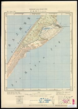
- Subject:
- Geographic Subject: Kosa, Topical Subject: Soviet Union, and Topical Subject: Maps
- Publisher:
- Генеральный штаб РККА
- Language:
- Russian
- Date Created:
- 1940
- Identifier:
- VAC9619-003727
- Genre:
- Military Maps and Topographic Maps
- Geographic Location:
- Coordinates: 54.5, 19.625, 54.583333, 19.75
- Related URL:
- Catalog URL: https://iucat.iu.edu/catalog/14701157 and Download GeoTIFF: https://drive.google.com/file/d/1uRhFbeHl9-dgswPSknIWvNdDvABJY8H9/view?usp=sharing
- Abstract:
- Modern area represented: Kosa, Kaliningrad oblast, Russia
- Call Number:
- G7063.K2 s25 .S6 sheet N-34-52-A-d
- City:
- Штраухбухт
- Copyright Holder:
- No Copyright - United States
- Country:
- Восточная Пруссия (East Prussia) and Германия (Germany)
- Physical Description:
- Scale: 1:25,000
- Persistent URL:
- http://purl.dlib.indiana.edu/iudl/images/VAC9619/VAC9619-003727
- Provenance:
- M. I. Map Library, G000-30, GS, RA
-
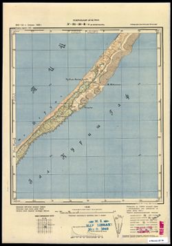
- Subject:
- Topical Subject: Soviet Union, Geographic Subject: Rybachiy, and Topical Subject: Maps
- Publisher:
- Генеральный штаб Красной Армии
- Language:
- Russian
- Date Created:
- 1940
- Identifier:
- VAC9619-003590
- Genre:
- Military Maps and Topographic Maps
- Geographic Location:
- Coordinates: 55.083, 20.75, 55.167, 20.875
- Related URL:
- Catalog URL: https://iucat.iu.edu/catalog/14701157 and Download GeoTIFF: https://drive.google.com/file/d/1JlpkAjeRU6ZM55Ej_M3cn9jjp0fom93V/view?usp=sharing
- Abstract:
- Modern area represented: Rybachiy, Kaliningrad oblast, Russia
- Call Number:
- G7063.K2 s25 .S6 sheet N-34-30-D-a
- City:
- Росситтен (Rossitten)
- Copyright Holder:
- No Copyright - United States
- Country:
- Германия (Germany) and Восточная Пруссия (East Prussia)
- Physical Description:
- Scale: 1:25,000
- Persistent URL:
- http://purl.dlib.indiana.edu/iudl/images/VAC9619/VAC9619-003590
- Provenance:
- M. I. Map Library, G000-30, GS, RA
-
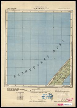
- Subject:
- Topical Subject: Soviet Union, Geographic Subject: Mys Ptichiy, and Topical Subject: Maps
- Publisher:
- Генеральный штаб РККА
- Language:
- Russian
- Date Created:
- 1940
- Identifier:
- VAC9619-003589
- Genre:
- Topographic Maps and Military Maps
- Geographic Location:
- Coordinates: 55, 20.625, 55.083, 20.75
- Related URL:
- Catalog URL: https://iucat.iu.edu/catalog/14701157 and Download GeoTIFF: https://drive.google.com/file/d/15WicBKNE8MRo4-2lVtS2fC8rJy6hMY_M/view?usp=sharing
- Abstract:
- Modern area represented: Mys Ptichiy, Kaliningrad oblast, Russia
- Call Number:
- G7063.K2 s25 .S6 sheet N-34-30-C-d
- City:
- Мевенхакен
- Copyright Holder:
- No Copyright - United States
- Country:
- Восточная Пруссия (East Prussia) and Германия (Germany)
- Physical Description:
- Scale: 1:25,000
- Persistent URL:
- http://purl.dlib.indiana.edu/iudl/images/VAC9619/VAC9619-003589
- Provenance:
- M. I. Map Library, G000-30, GS, RA

- « Previous
- Next »
- 1
- 2
- 3