
Search Constraints
You searched for:
Campus
IUB
Remove constraint Campus: IUB
Country
Германия (Germany)
Remove constraint Country: Германия (Germany)
Type
Image
Remove constraint Type: Image
Publisher
Генеральный штаб РККА
Remove constraint Publisher: Генеральный штаб РККА
1 - 39 of 39
Search Results
-
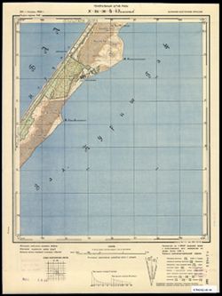
- Description:
- 1924
- Subject:
- Geographic Subject: Inowroclaw, Topical Subject: Soviet Union, and Topical Subject: Maps
- Publisher:
- Генеральный штаб РККА
- Language:
- Russian
- Date Created:
- 1940
- Identifier:
- VAC9619-003974
- Genre:
- Military Maps and Topographic Maps
- Geographic Location:
- Coordinates: 52.667, 18, 53, 18.5
- Related URL:
- Catalog URL: https://iucat.iu.edu/catalog/5020129 and Download GeoTIFF: https://drive.google.com/file/d/1wretOfm4Ek7X9aIbeZAfJ7WbxN6jJ09r/view?usp=sharing
- Abstract:
- Modern area represented: Inowroclaw, Kuyavian-Pomeranian Voivodeship, Poland
- Call Number:
- G7000 s100 .S7 sheet N-34-109
- City:
- Иновроцлав (Inowroclaw)
- Copyright Holder:
- No Copyright - United States
- Country:
- Германия (Germany)
- State/Province:
- Область государственных интересов Германии (Region of German state interests)
- Physical Description:
- Scale: 1:100,000
- Persistent URL:
- http://purl.dlib.indiana.edu/iudl/images/VAC9619/VAC9619-003974
- Provenance:
- DMA Topographic Center, Army Map Service Library, OMAHA
-
- Description:
- 1929
- Subject:
- Topical Subject: Maps, Topical Subject: Soviet Union, and Geographic Subject: Przasnysz
- Publisher:
- Генеральный штаб РККА
- Language:
- Russian
- Date Created:
- 1936
- Identifier:
- VAC9619-003968
- Genre:
- Military Maps and Topographic Maps
- Geographic Location:
- Coordinates: 53, 20.5, 53.333, 21
- Related URL:
- Catalog URL: https://iucat.iu.edu/catalog/5020129 and Download GeoTIFF: https://drive.google.com/file/d/1lSBsKEQj_ti2B2TCzPMbQsf-4n3GFsZO/view?usp=sharing
- Abstract:
- Modern area represented: Przasnysz, Masovian Voivodship, Poland
- Call Number:
- G7000 s100 .S7 sheet N-34-102
- City:
- Пжасныш (Przasnysz)
- Copyright Holder:
- No Copyright - United States
- Country:
- Германия (Germany)
- State/Province:
- Область государственных интересов Германии (Region of German state interests)
- Physical Description:
- Scale: 1:100,000
- Persistent URL:
- http://purl.dlib.indiana.edu/iudl/images/VAC9619/VAC9619-003968
- Provenance:
- DMA Topographic Center, Army Map Service Library, Auswärtiges Amt. Geographischer Dienst
-
- Description:
- 1924
- Subject:
- Topical Subject: Maps, Topical Subject: Soviet Union, and Geographic Subject: Mława
- Publisher:
- Генеральный штаб РККА
- Language:
- Russian
- Date Created:
- 1936
- Identifier:
- VAC9619-003967
- Genre:
- Topographic Maps and Military Maps
- Geographic Location:
- Coordinates: 53, 20, 53.333, 20.5
- Related URL:
- Download GeoTIFF: https://drive.google.com/file/d/1QIhXg78SpLv4gIZa_N6lbUv5nS9F4-aa/view?usp=sharing and Catalog URL: https://iucat.iu.edu/catalog/5020129
- Abstract:
- Modern area represented: Mława, Masovian Voivodeship, Poland
- Call Number:
- G7000 s100 .S7 sheet N-34-101
- City:
- Млава (Mława)
- Copyright Holder:
- No Copyright - United States
- Country:
- Германия (Germany)
- State/Province:
- Область государственных интересов Германии (Region of German state interests)
- Physical Description:
- Scale: 1:100,000
- Persistent URL:
- http://purl.dlib.indiana.edu/iudl/images/VAC9619/VAC9619-003967
- Provenance:
- DMA Topographic Center, Army Map Service Library
-
- Description:
- 1919
- Subject:
- Geographic Subject: Lidzbark Warmiński, Topical Subject: Maps, and Topical Subject: Soviet Union
- Publisher:
- Генеральный штаб РККА
- Language:
- Russian
- Date Created:
- 1934
- Identifier:
- VAC9619-003966
- Genre:
- Military Maps and Topographic Maps
- Geographic Location:
- Coordinates: 53, 19.5, 53.333, 20
- Related URL:
- Catalog URL: https://iucat.iu.edu/catalog/5020129 and Download GeoTIFF: https://drive.google.com/file/d/1b6-h38Tzskzru8fV-gooKBZmiwM5-JiX/view?usp=sharing
- Abstract:
- Modern area represented: Lidzbark Warmiński, Warmian-Masurian Voivodeship, Poland
- Call Number:
- G7000 s100 .S7 sheet N-34-100
- City:
- Лидзбарк (Lidzbark)
- Copyright Holder:
- No Copyright - United States
- Country:
- Германия (Germany)
- State/Province:
- Область государственных интересов Германии (Region of German state interests)
- Physical Description:
- Scale: 1:100,000
- Persistent URL:
- http://purl.dlib.indiana.edu/iudl/images/VAC9619/VAC9619-003966
- Provenance:
- DMA Topographic Center, Army Map Service Library
-
- Description:
- 1922
- Subject:
- Geographic Subject: Szczuczyn, Topical Subject: Maps, and Topical Subject: Soviet Union
- Publisher:
- Генеральный штаб РККА
- Language:
- Russian
- Date Created:
- 1936
- Identifier:
- VAC9619-003960
- Genre:
- Military Maps and Topographic Maps
- Geographic Location:
- Coordinates: 53.333, 22, 53.667, 22.5
- Related URL:
- Catalog URL: https://iucat.iu.edu/catalog/5020129 and Download GeoTIFF: https://drive.google.com/file/d/1x55tn0y3lblxyZAejcN6GNjNfT9tjLHc/view?usp=sharing
- Abstract:
- Modern area represented: Szczuczyn, Podlasie, Poland
- Call Number:
- G7000 s100 .S7 sheet N-34-93
- City:
- Щучын (Szczuczyn)
- Copyright Holder:
- No Copyright - United States
- Country:
- Германия (Germany) and СССР (USSR)
- State/Province:
- Белорусская ССР (Byelorussian Soviet Socialist Republic)
- Physical Description:
- Scale: 1:100,000
- Persistent URL:
- http://purl.dlib.indiana.edu/iudl/images/VAC9619/VAC9619-003960
- Provenance:
- DMA Topographic Center, Army Map Service Library, OMAHA
-
- Description:
- 1916
- Subject:
- Geographic Subject: Janowo, Topical Subject: Maps, and Topical Subject: Soviet Union
- Publisher:
- Генеральный штаб РККА
- Language:
- Russian
- Date Created:
- 1936
- Identifier:
- VAC9619-003959
- Genre:
- Topographic Maps and Military Maps
- Geographic Location:
- Coordinates: 53.333, 21.5, 53.667, 22
- Related URL:
- Catalog URL: https://iucat.iu.edu/catalog/5020129 and Download GeoTIFF: https://drive.google.com/file/d/1V9_BtRhfFGWhUMbvWGMSthlnHu_vi1pv/view?usp=sharing
- Abstract:
- Modern area represented: Janowo, Warmia-Masuria, Poland
- Call Number:
- G7000 s100 .S7 sheet N-34-92
- City:
- Иоганнисбург (Johannisberg)
- Copyright Holder:
- No Copyright - United States
- Country:
- СССР (USSR) and Германия (Germany)
- State/Province:
- Белорусская ССР (Byelorussian Soviet Socialist Republic), Область государственных интересов Германии (Region of German state interests), and Белостокская обл...
- Physical Description:
- Scale: 1:100,000
- Persistent URL:
- http://purl.dlib.indiana.edu/iudl/images/VAC9619/VAC9619-003959
- Provenance:
- DMA Topographic Center, Army Map Service Library
-
- Description:
- 1910
- Subject:
- Topical Subject: Maps, Geographic Subject: Myszyniec, and Topical Subject: Soviet Union
- Publisher:
- Генеральный штаб РККА
- Language:
- Russian
- Date Created:
- 1936
- Identifier:
- VAC9619-003958
- Genre:
- Military Maps and Topographic Maps
- Geographic Location:
- Coordinates: 53.333, 21, 53.667, 21.5
- Related URL:
- Download GeoTIFF: https://drive.google.com/file/d/1B6ZEwsNeUZ6BWE_--ZMSM0vuCXUzT4tV/view?usp=sharing and Catalog URL: https://iucat.iu.edu/catalog/5020129
- Abstract:
- Modern area represented: Myszyniec, Mazovia, Poland
- Call Number:
- G7000 s100 .S7 sheet N-34-91
- City:
- Мышинец (Myszyniec)
- Copyright Holder:
- No Copyright - United States
- Country:
- Германия (Germany)
- State/Province:
- Область государственных интересов Германии (Region of German state interests)
- Physical Description:
- Scale: 1:100,000
- Persistent URL:
- http://purl.dlib.indiana.edu/iudl/images/VAC9619/VAC9619-003958
- Provenance:
- DMA Topographic Center, Army Map Service Library
-
- Description:
- 1914
- Subject:
- Topical Subject: Maps, Topical Subject: Soviet Union, and Geographic Subject: Szczytno
- Publisher:
- Генеральный штаб РККА
- Language:
- Russian
- Date Created:
- 1936
- Identifier:
- VAC9619-003957
- Genre:
- Topographic Maps and Military Maps
- Geographic Location:
- Coordinates: 53.333, 20.5, 53.667, 21
- Related URL:
- Catalog URL: https://iucat.iu.edu/catalog/5020129 and Download GeoTIFF: https://drive.google.com/file/d/1PGwif-x5nWuOwkHqZXDxeLjCMtPziPN9/view?usp=sharing
- Abstract:
- Modern area represented: Szczytno, Warmia-Masuria, Poland
- Call Number:
- G7000 s100 .S7 sheet N-34-90
- City:
- Ортельсбург (Ortelsburg)
- Copyright Holder:
- No Copyright - United States
- Country:
- Германия (Germany)
- State/Province:
- Область государственных интересов Германии (Region of German state interests)
- Physical Description:
- Scale: 1:100,000
- Persistent URL:
- http://purl.dlib.indiana.edu/iudl/images/VAC9619/VAC9619-003957
- Provenance:
- DMA Topographic Center, Army Map Service Library
-
- Description:
- 1929
- Subject:
- Topical Subject: Maps, Geographic Subject: Olsztynek, and Topical Subject: Soviet Union
- Publisher:
- Генеральный штаб РККА
- Language:
- Russian
- Date Created:
- 1936
- Identifier:
- VAC9619-003956
- Genre:
- Military Maps and Topographic Maps
- Geographic Location:
- Coordinates: 53.333, 20, 53.667, 20.5
- Related URL:
- Download GeoTIFF: https://drive.google.com/file/d/1buUda318Lq2zsO4SHgHXZckJJuRy45vx/view?usp=sharing and Catalog URL: https://iucat.iu.edu/catalog/5020129
- Abstract:
- Modern area represented: Olsztynek, Warmia-Masuria, Poland
- Call Number:
- G7000 s100 .S7 sheet N-34-89
- City:
- Хохенштайн (Hohenstein)
- Copyright Holder:
- No Copyright - United States
- Country:
- Германия (Germany)
- Physical Description:
- Scale: 1:100,000
- Persistent URL:
- http://purl.dlib.indiana.edu/iudl/images/VAC9619/VAC9619-003956
- Provenance:
- DMA Topographic Center, Army Map Service Library, OMAHA
-
- Description:
- 1911
- Subject:
- Geographic Subject: Lubawa, Topical Subject: Soviet Union, and Topical Subject: Maps
- Publisher:
- Генеральный штаб РККА
- Language:
- Russian
- Date Created:
- 1936
- Identifier:
- VAC9619-003955
- Genre:
- Topographic Maps and Military Maps
- Geographic Location:
- Coordinates: 53.333, 19.5, 53.667, 20
- Related URL:
- Catalog URL: https://iucat.iu.edu/catalog/5020129 and Download GeoTIFF: https://drive.google.com/file/d/1T8Q9d-qnPW0VZuYvESGyginsS0dOibxj/view?usp=sharing
- Abstract:
- Modern area represented: Lubawa, Warmia-Masuria, Poland
- Call Number:
- G7000 s100 .S7 sheet N-34-88
- City:
- Любава (Lubawa)
- Copyright Holder:
- No Copyright - United States
- Country:
- Германия (Germany)
- Physical Description:
- Scale: 1:100,000
- Persistent URL:
- http://purl.dlib.indiana.edu/iudl/images/VAC9619/VAC9619-003955
- Provenance:
- DMA Topographic Center, Army Map Service Library
-
- Description:
- 1925
- Subject:
- Topical Subject: Soviet Union, Geographic Subject: Augustów, and Topical Subject: Maps
- Publisher:
- Генеральный штаб РККА
- Language:
- Russian
- Identifier:
- VAC9619-003949
- Genre:
- Military Maps and Topographic Maps
- Geographic Location:
- Coordinates: 53.667, 22.5, 54, 23
- Related URL:
- Download GeoTIFF: https://drive.google.com/file/d/1cU66jzensBQE5jd3OSh_8wYEjiXVqWC-/view?usp=sharing and Catalog URL: https://iucat.iu.edu/catalog/5020129
- Abstract:
- Modern area represented: Augustów, Podlasie, Poland
- Call Number:
- G7000 s100 .S7 sheet N-34-82
- City:
- Августув (Augustów)
- Copyright Holder:
- No Copyright - United States
- Country:
- СССР (USSR) and Германия (Germany)
- State/Province:
- Область государственных интересов Германии (Region of German state interests) and Белорусская ССР (Byelorussian Soviet Socialist Republic)
- Physical Description:
- Scale: 1:100,000
- Persistent URL:
- http://purl.dlib.indiana.edu/iudl/images/VAC9619/VAC9619-003949
- Provenance:
- DMA Topographic Center, Army Map Service Library, Atlasblatt
-
- Description:
- 1925
- Subject:
- Topical Subject: Maps and Topical Subject: Soviet Union
- Publisher:
- Генеральный штаб РККА
- Language:
- Russian
- Date Created:
- 1932
- Identifier:
- VAC9619-003948
- Genre:
- Topographic Maps and Military Maps
- Geographic Location:
- Coordinates: 53.667, 22, 54, 22.5
- Related URL:
- Catalog URL: https://iucat.iu.edu/catalog/5020129 and Download GeoTIFF: https://drive.google.com/file/d/14ciSWOni-z2UfNW-sIdCLfEd5I6uNINs/view?usp=sharing
- Abstract:
- Modern area represented: Poland
- Call Number:
- G7000 s100 .S7 sheet N-34-81
- City:
- Ликк (Likk)
- Copyright Holder:
- No Copyright - United States
- Country:
- СССР (USSR) and Германия (Germany)
- State/Province:
- Белорусская ССР (Byelorussian Soviet Socialist Republic)
- Physical Description:
- Scale: 1:100,000
- Persistent URL:
- http://purl.dlib.indiana.edu/iudl/images/VAC9619/VAC9619-003948
- Provenance:
- DMA Topographic Center, Army Map Service Library
-
- Description:
- 1911
- Subject:
- Topical Subject: Maps, Topical Subject: Soviet Union, and Geographic Subject: Zblewo
- Publisher:
- Генеральный штаб РККА
- Language:
- Russian
- Date Created:
- 1929
- Identifier:
- VAC9619-003941
- Genre:
- Topographic Maps and Military Maps
- Geographic Location:
- Coordinates: 53.667, 18, 54, 18.5
- Related URL:
- Catalog URL: https://iucat.iu.edu/catalog/5020129 and Download GeoTIFF: https://drive.google.com/file/d/1dBvNtil78at3rfiUQctHXeRInWeyy0u0/view?usp=sharing
- Abstract:
- Modern area represented: Zblewo, Pomeranian voivodeship, Poland
- Call Number:
- G7000 s100 .S7 sheet N-34-73
- City:
- Зблево (Zblewo)
- Copyright Holder:
- No Copyright - United States
- Country:
- Германия (Germany)
- Physical Description:
- Scale: 1:100,000
- Persistent URL:
- http://purl.dlib.indiana.edu/iudl/images/VAC9619/VAC9619-003941
- Provenance:
- DMA Topographic Center, Army Map Service Library, OMAHA
-
- Description:
- 1922
- Subject:
- Topical Subject: Soviet Union, Topical Subject: Maps, and Geographic Subject: Suwalki
- Publisher:
- Генеральный штаб РККА
- Language:
- Russian
- Date Created:
- 1936
- Identifier:
- VAC9619-003938
- Genre:
- Topographic Maps and Military Maps
- Geographic Location:
- Coordinates: 54.0, 22.5, 54.3333, 23.0
- Related URL:
- Catalog URL: https://iucat.iu.edu/catalog/5020129 and Download GeoTIFF: https://drive.google.com/file/d/1_Vnz1OW4YgD2F43wKc9msJYUYJg2lnqD/view?usp=sharing
- Abstract:
- Modern area represented: Suwalki, Podlaskie voivodeship, Poland
- Call Number:
- G7000 s100 .S7 sheet N-34-70
- City:
- Сувалки (Suwalki)
- Copyright Holder:
- No Copyright - United States
- Country:
- Германия (Germany)
- State/Province:
- Область государственных интересов Германии (Region of German state interests)
- Physical Description:
- Scale: 1:100,000
- Persistent URL:
- http://purl.dlib.indiana.edu/iudl/images/VAC9619/VAC9619-003938
- Provenance:
- DMA Topographic Center, Army Map Service Library
-
- Description:
- 1891
- Subject:
- Geographic Subject: Nesterov, Topical Subject: Soviet Union, and Topical Subject: Maps
- Publisher:
- Генеральный штаб РККА
- Language:
- Russian
- Date Created:
- 1931
- Identifier:
- VAC9619-003927
- Genre:
- Topographic Maps and Military Maps
- Geographic Location:
- Coordinates: 54.333, 22.5, 54.667, 23
- Related URL:
- Catalog URL: https://iucat.iu.edu/catalog/5020129 and Download GeoTIFF: https://drive.google.com/file/d/17HW3aqTETkGc2vQ4G3N9nIj4-_F0Brz0/view?usp=sharing
- Abstract:
- Modern area represented: Nesterov, Kaliningrad oblast, Russia
- Call Number:
- G7000 s100 .S7 sheet N-34-58
- City:
- Шталлупенен (Stallupönen)
- Copyright Holder:
- No Copyright - United States
- Country:
- Германия (Germany) and Литва (Lithuania)
- Physical Description:
- Scale: 1:100,000
- Persistent URL:
- http://purl.dlib.indiana.edu/iudl/images/VAC9619/VAC9619-003927
- Provenance:
- DMA Topographic Center, Army Map Service Library, OMAHA
-
- Subject:
- Topical Subject: Soviet Union, Topical Subject: Maps, and Geographic Subject: Gusev
- Publisher:
- Генеральный штаб РККА
- Language:
- Russian
- Date Created:
- 1934
- Identifier:
- VAC9619-003926
- Genre:
- Military Maps and Topographic Maps
- Geographic Location:
- Coordinates: 54.333, 22, 54.667, 22.5
- Related URL:
- Catalog URL: https://iucat.iu.edu/catalog/5020129 and Download GeoTIFF: https://drive.google.com/file/d/1B5vbfmp9KRy5TDJCUwOruI-bHXiBzj6V/view?usp=sharing
- Abstract:
- Modern area represented: Gusev, Kaliningrad oblast, Russia
- Call Number:
- G7000 s100 .S7 sheet N-34-57
- City:
- Гумбиннен (Gumbinnen)
- Copyright Holder:
- No Copyright - United States
- Country:
- Германия (Germany)
- Physical Description:
- Scale: 1:100,000
- Persistent URL:
- http://purl.dlib.indiana.edu/iudl/images/VAC9619/VAC9619-003926
- Provenance:
- DMA Topographic Center, Army Map Service Library, OMAHA
-

- Description:
- 1908
- Subject:
- Topical Subject: Maps, Geographic Subject: Łysica, and Topical Subject: Soviet Union
- Publisher:
- Генеральный штаб РККА
- Language:
- Russian
- Date Created:
- 1936
- Identifier:
- VAC9619-003920
- Genre:
- Military Maps and Topographic Maps
- Geographic Location:
- Coordinates: 54.333, 19, 54.667, 19.5
- Related URL:
- Catalog URL: https://iucat.iu.edu/catalog/5020129 and Download GeoTIFF: https://drive.google.com/file/d/1I1LMaLxtTQ7DlLg_N8JfYA0vjryE0bgf/view?usp=sharing
- Abstract:
- Modern area represented: Łysica, Pomerania, Poland
- Call Number:
- G7000 s100 .S7 sheet N-34-51
- City:
- Кальберг-Лип (Kahlberg Liep)
- Copyright Holder:
- No Copyright - United States
- Country:
- Германия (Germany)
- State/Province:
- Восточная Пруссия (East Prussia)
- Physical Description:
- Scale: 1:100,000
- Persistent URL:
- http://purl.dlib.indiana.edu/iudl/images/VAC9619/VAC9619-003920
- Provenance:
- DMA Topographic Center, Army Map Service Library, OMAHA
-
- Description:
- 1894
- Subject:
- Topical Subject: Soviet Union, Topical Subject: Maps, and Geographic Subject: Šilutė
- Publisher:
- Генеральный штаб РККА
- Language:
- Russian
- Date Created:
- 1940
- Identifier:
- VAC9619-003900
- Genre:
- Military Maps and Topographic Maps
- Geographic Location:
- Coordinates: 55.333, 21, 55.667, 21.5
- Related URL:
- Download GeoTIFF: https://drive.google.com/file/d/1RE5ztvBFBVzWdrQ615UuvzpQTXcB95Eb/view?usp=sharing and Catalog URL: https://iucat.iu.edu/catalog/5020129
- Abstract:
- Modern area represented: Šilutė, Klaipėda County, Lithuania
- Call Number:
- G7000 s100 .S7 sheet N-34-19
- City:
- Шилутэ (Šilutė)
- Copyright Holder:
- No Copyright - United States
- Country:
- Германия (Germany) and Литва (Lithuania)
- Physical Description:
- Scale: 1:100,000
- Persistent URL:
- http://purl.dlib.indiana.edu/iudl/images/VAC9619/VAC9619-003900
- Provenance:
- DMA Topographic Center, Army Map Service Library, OMAHA, Geographic Names Branch
-
- Description:
- 1909
- Subject:
- Geographic Subject: Nakło nad Notecią, Topical Subject: Maps, and Topical Subject: Soviet Union
- Publisher:
- Генеральный штаб РККА
- Language:
- Russian
- Date Created:
- 1925
- Identifier:
- VAC9619-003879
- Genre:
- Topographic Maps and Military Maps
- Geographic Location:
- Coordinates: 53, 17.5, 53.333, 18
- Related URL:
- Download GeoTIFF: https://drive.google.com/file/d/1Y43GJTSA8DysouAljQWn6AWfsFnFdki8/view?usp=sharing and Catalog URL: https://iucat.iu.edu/catalog/5020129
- Abstract:
- Modern area represented: Nakło nad Notecią, Kujawsko-Pomorskie, Poland
- Call Number:
- G7000 s100 .S7 sheet N-33-108
- City:
- Накло (Naklo)
- Copyright Holder:
- No Copyright - United States
- Country:
- Германия (Germany)
- Physical Description:
- Scale: 1:100,000
- Persistent URL:
- http://purl.dlib.indiana.edu/iudl/images/VAC9619/VAC9619-003879
- Provenance:
- DMA Topographic Center, Army Map Service Library
-
- Description:
- 1877
- Subject:
- Topical Subject: Maps, Geographic Subject: Drawsko Pomorskie, and Topical Subject: Soviet Union
- Publisher:
- Генеральный штаб РККА
- Language:
- Russian
- Date Created:
- 1940
- Identifier:
- VAC9619-003871
- Genre:
- Military Maps and Topographic Maps
- Geographic Location:
- Coordinates: 53.333, 15.5, 53.667, 16
- Related URL:
- Download GeoTIFF: https://drive.google.com/file/d/1kZMEmT3bY-AuXddXUMmGvXRW5Z2BHrgy/view?usp=sharing and Catalog URL: https://iucat.iu.edu/catalog/5020129
- Abstract:
- Modern area represented: Drawsko Pomorskie, West Pomeranian Voivodeship, Poland
- Call Number:
- G7000 s100 .S7 sheet N-33-92
- City:
- Драмбург (Dramburg)
- Copyright Holder:
- No Copyright - United States
- Country:
- Германия (Germany)
- Physical Description:
- Scale: 1:100,000
- Persistent URL:
- http://purl.dlib.indiana.edu/iudl/images/VAC9619/VAC9619-003871
- Provenance:
- DMA Topographic Center, Army Map Service Library, Auswärtiges Amt. Geographischer Dienst
-
- Description:
- 1921
- Subject:
- Topical Subject: Maps, Topical Subject: Soviet Union, and Geographic Subject: Pomeranian Voivodeship
- Publisher:
- Генеральный штаб РККА
- Language:
- Russian
- Date Created:
- 1940
- Identifier:
- VAC9619-003869
- Genre:
- Topographic Maps and Military Maps
- Geographic Location:
- Coordinates: 53.667, 17, 54, 17.5
- Related URL:
- Download GeoTIFF: https://drive.google.com/file/d/1ECQb8yIcYW04beF4Fx_4EfgbRIo6n1fH/view?usp=sharing and Catalog URL: https://iucat.iu.edu/catalog/5020129
- Abstract:
- Modern area represented: Pomeranian Voivodeship, Poland
- Call Number:
- G7000 s100 .S7 sheet N-33-83
- City:
- Прехлау (Priechlau)
- Copyright Holder:
- No Copyright - United States
- Country:
- Германия (Germany)
- Physical Description:
- Scale: 1:100,000
- Persistent URL:
- http://purl.dlib.indiana.edu/iudl/images/VAC9619/VAC9619-003869
- Provenance:
- DMA Topographic Center, Army Map Service Library
-
- Description:
- 1889
- Subject:
- Topical Subject: Maps, Topical Subject: Soviet Union, and Geographic Subject: Świdwin
- Publisher:
- Генеральный штаб РККА
- Language:
- Russian
- Date Created:
- 1940
- Identifier:
- VAC9619-003866
- Genre:
- Topographic Maps and Military Maps
- Geographic Location:
- Coordinates: 53.667, 15.5, 54, 16
- Related URL:
- Catalog URL: https://iucat.iu.edu/catalog/5020129 and Download GeoTIFF: https://drive.google.com/file/d/1Zn5NvbsNWHhQkJYyoLYcf4Z1YKkgoGxD/view?usp=sharing
- Abstract:
- Modern area represented: Świdwin, West Pomerania, Poland
- Call Number:
- G7000 s100 .S7 sheet N-33-80
- City:
- Шифельбайн (Schivelbein)
- Copyright Holder:
- No Copyright - United States
- Country:
- Германия (Germany)
- Physical Description:
- Scale: 1:100,000
- Persistent URL:
- http://purl.dlib.indiana.edu/iudl/images/VAC9619/VAC9619-003866
- Provenance:
- DMA Topographic Center, Army Map Service Library, Auswärtiges Amt. Geographischer Dienst
-
- Subject:
- Geographic Subject: Kosa, Topical Subject: Soviet Union, and Topical Subject: Maps
- Publisher:
- Генеральный штаб РККА
- Language:
- Russian
- Date Created:
- 1940
- Identifier:
- VAC9619-003727
- Genre:
- Military Maps and Topographic Maps
- Geographic Location:
- Coordinates: 54.5, 19.625, 54.583333, 19.75
- Related URL:
- Catalog URL: https://iucat.iu.edu/catalog/14701157 and Download GeoTIFF: https://drive.google.com/file/d/1uRhFbeHl9-dgswPSknIWvNdDvABJY8H9/view?usp=sharing
- Abstract:
- Modern area represented: Kosa, Kaliningrad oblast, Russia
- Call Number:
- G7063.K2 s25 .S6 sheet N-34-52-A-d
- City:
- Штраухбухт
- Copyright Holder:
- No Copyright - United States
- Country:
- Восточная Пруссия (East Prussia) and Германия (Germany)
- Physical Description:
- Scale: 1:25,000
- Persistent URL:
- http://purl.dlib.indiana.edu/iudl/images/VAC9619/VAC9619-003727
- Provenance:
- M. I. Map Library, G000-30, GS, RA
-
- Subject:
- Topical Subject: Soviet Union, Geographic Subject: Mys Ptichiy, and Topical Subject: Maps
- Publisher:
- Генеральный штаб РККА
- Language:
- Russian
- Date Created:
- 1940
- Identifier:
- VAC9619-003589
- Genre:
- Topographic Maps and Military Maps
- Geographic Location:
- Coordinates: 55, 20.625, 55.083, 20.75
- Related URL:
- Catalog URL: https://iucat.iu.edu/catalog/14701157 and Download GeoTIFF: https://drive.google.com/file/d/15WicBKNE8MRo4-2lVtS2fC8rJy6hMY_M/view?usp=sharing
- Abstract:
- Modern area represented: Mys Ptichiy, Kaliningrad oblast, Russia
- Call Number:
- G7063.K2 s25 .S6 sheet N-34-30-C-d
- City:
- Мевенхакен
- Copyright Holder:
- No Copyright - United States
- Country:
- Восточная Пруссия (East Prussia) and Германия (Germany)
- Physical Description:
- Scale: 1:25,000
- Persistent URL:
- http://purl.dlib.indiana.edu/iudl/images/VAC9619/VAC9619-003589
- Provenance:
- M. I. Map Library, G000-30, GS, RA
-
- Subject:
- Topical Subject: Soviet Union, Geographic Subject: Lesnoy, and Topical Subject: Maps
- Publisher:
- Генеральный штаб РККА
- Language:
- Russian
- Date Created:
- 1940
- Identifier:
- VAC9619-003588
- Genre:
- Military Maps and Topographic Maps
- Geographic Location:
- Coordinates: 55, 20.5, 55.083, 20.625
- Related URL:
- Catalog URL: https://iucat.iu.edu/catalog/14701157 and Download GeoTIFF: https://drive.google.com/file/d/1iAyyaQlcH3PgnIB6KJJKHwl0iTJ-n3-D/view?usp=sharing
- Abstract:
- Modern area represented: Lesnoy, Kaliningrad oblast, Russia
- Call Number:
- G7063.K2 s25 .S6 sheet N-34-30-C-c
- City:
- Заркау (Zarkau)
- Copyright Holder:
- No Copyright - United States
- Country:
- Германия (Germany) and Восточная Пруссия (East Prussia)
- Physical Description:
- Scale: 1:25,000
- Persistent URL:
- http://purl.dlib.indiana.edu/iudl/images/VAC9619/VAC9619-003588
- Provenance:
- CIA Map Branch -- Received, G000-30
-
- Subject:
- Topical Subject: Soviet Union, Topical Subject: Maps, and Geographic Subject: Morskoye
- Publisher:
- Генеральный штаб РККА
- Language:
- Russian
- Date Created:
- 1940
- Identifier:
- VAC9619-003586
- Genre:
- Military Maps and Topographic Maps
- Geographic Location:
- Coordinates: 55.167, 20.875, 55.25, 21
- Related URL:
- Catalog URL: https://iucat.iu.edu/catalog/14701157 and Download GeoTIFF: https://drive.google.com/file/d/1Rsb9vB0P3JuEDMdk-KNbVt1oSoBEfUAp/view?usp=sharing
- Abstract:
- Modern area represented: Morskoye, Kaliningrad oblast, Russia
- Call Number:
- G7063.K2 s25 .S6 sheet N-34-30-B-d
- City:
- Пиллкоппен (Pillkoppen)
- Copyright Holder:
- No Copyright - United States
- Country:
- Восточная Пруссия (East Prussia) and Германия (Germany)
- Physical Description:
- Scale: 1:25,000
- Persistent URL:
- http://purl.dlib.indiana.edu/iudl/images/VAC9619/VAC9619-003586
- Provenance:
- CIA Map Branch -- Received, G000-30
-

- Description:
- 1889
- Subject:
- Geographic Subject: Kołobrzeg, Topical Subject: Maps, and Topical Subject: Soviet Union
- Publisher:
- Генеральный штаб РККА
- Language:
- Russian
- Date Created:
- 1940
- Identifier:
- VAC9619-003567
- Genre:
- Topographic Maps and Military Maps
- Geographic Location:
- Coordinates: 54, 15.5, 54.333, 16
- Related URL:
- Catalog URL: https://iucat.iu.edu/catalog/5020129 and Download GeoTIFF: https://drive.google.com/file/d/1X9RLb-NA1jLTLaCTQk2Mx-_X0nO9kXgc/view?usp=sharing
- Abstract:
- Modern area represented: Kołobrzeg, West Pomerania province, Poland
- Call Number:
- G7000 s100 .S7 sheet N-33-68
- City:
- Ко́льберг (Kolberg)
- Copyright Holder:
- No Copyright - United States
- Country:
- Германия (Germany)
- Physical Description:
- Scale: 1:100,000
- Persistent URL:
- http://purl.dlib.indiana.edu/iudl/images/VAC9619/VAC9619-003567
- Provenance:
- DMA Topographic Center, Army Map Service Library, Heeresplankammer Gruppe Archive Auslandskartenarchiv
-
- Description:
- 1890
- Subject:
- Topical Subject: Soviet Union, Geographic Subject: Darłowo, and Topical Subject: Maps
- Publisher:
- Генеральный штаб РККА
- Language:
- Russian
- Date Created:
- 1940
- Identifier:
- VAC9619-003563
- Genre:
- Military Maps and Topographic Maps
- Geographic Location:
- Coordinates: 54.333, 16, 54.667, 16.5
- Related URL:
- Download GeoTIFF: https://drive.google.com/file/d/1nkgJQP1YCZZMvFiZpCeeWK15exzGHer4/view?usp=sharing and Catalog URL: https://iucat.iu.edu/catalog/5020129
- Abstract:
- Modern area represented: Darłowo, West Pomerania province, Poland
- Call Number:
- G7000 s100 .S7 sheet N-33-57
- City:
- Рюгенвальде (Rügenwalde)
- Copyright Holder:
- No Copyright - United States
- Country:
- Германия (Germany)
- Physical Description:
- Scale: 1:100,000
- Persistent URL:
- http://purl.dlib.indiana.edu/iudl/images/VAC9619/VAC9619-003563
- Provenance:
- DMA Topographic Center, Army Map Service Library
-
- Description:
- 1889
- Subject:
- Geographic Subject: Izbica, Topical Subject: Maps, and Topical Subject: Soviet Union
- Publisher:
- Генеральный штаб РККА
- Language:
- Russian
- Date Created:
- 1940
- Identifier:
- VAC9619-003561
- Genre:
- Topographic Maps and Military Maps
- Geographic Location:
- Coordinates: 54.667, 17, 55, 17.5
- Related URL:
- Download GeoTIFF: https://drive.google.com/file/d/1jgimCqhUKreoPlh9ZZ57DAi5wmcomXg0/view?usp=sharing and Catalog URL: https://iucat.iu.edu/catalog/5020129
- Abstract:
- Modern area represented: Izbica, Pomerania province, Poland
- Call Number:
- G7000 s100 .S7 sheet N-33-47
- City:
- Гизебиц (Izbica)
- Copyright Holder:
- No Copyright - United States
- Country:
- Германия (Germany)
- Physical Description:
- Scale: 1:100,000
- Persistent URL:
- http://purl.dlib.indiana.edu/iudl/images/VAC9619/VAC9619-003561
- Provenance:
- DMA Topographic Center, Army Map Service Library
-
- Subject:
- Topical Subject: Maps, Geographic Subject: Ostrava, and Topical Subject: Soviet Union
- Publisher:
- Генеральный штаб РККА
- Language:
- Russian
- Identifier:
- VAC9619-002870
- Genre:
- Topographic Maps and Military Maps
- Geographic Location:
- Coordinates: 49.667, 18, 50, 18.5
- Related URL:
- Catalog URL: https://iucat.iu.edu/catalog/5020129 and Download GeoTIFF: https://drive.google.com/file/d/1OjvHezWlaQqX0XjfRTSy9iu_7Zy4fWVy/view?usp=sharing
- Abstract:
- Modern area represented: Ostrava, Moravskoslezský region, Czech Republic
- Call Number:
- G7000 s100 .S7 sheet M-34-73
- City:
- Морав. Острава (Moravian Ostrava)
- Copyright Holder:
- No Copyright - United States
- Country:
- Германия (Germany) and Чехословакия (Czechoslovakia)
- Physical Description:
- Scale: 1:100,000
- Persistent URL:
- http://purl.dlib.indiana.edu/iudl/images/VAC9619/VAC9619-002870
- Provenance:
- DMA Topographic Center, Army Map Service Library, OMAHA
-
- Description:
- 1887
- Subject:
- Geographic Subject: Břeclav, Topical Subject: Maps, and Topical Subject: Soviet Union
- Publisher:
- Генеральный штаб РККА
- Language:
- Russian
- Date Created:
- 1940
- Identifier:
- VAC9619-002716
- Genre:
- Topographic Maps and Military Maps
- Geographic Location:
- Coordinates: 48.667, 16.5, 49, 17
- Related URL:
- Download GeoTIFF: https://drive.google.com/file/d/1Xz9QjEJFlda42zTIvCh3f9f004Vs9M1C/view?usp=sharing and Catalog URL: https://iucat.iu.edu/catalog/5020129
- Abstract:
- Modern area represented: Břeclav, South Moravian region, Czech Republic
- Call Number:
- G7000 s100 .S7 sheet M-33-118
- City:
- Бржеслав (Břeclav)
- Copyright Holder:
- No Copyright - United States
- Country:
- Словакия (Slovakia) and Германия (Germany)
- State/Province:
- Протекторат Богемии и Моравии (Protectorate of Bohemia and Moravia)
- Physical Description:
- Scale: 1:100,000
- Persistent URL:
- http://purl.dlib.indiana.edu/iudl/images/VAC9619/VAC9619-002716
- Provenance:
- DMA Topographic Center, Library of Congress Geography & Map Division, Army Map Service Library
-
- Description:
- 1940
- Subject:
- Geographic Subject: Olomouc, Topical Subject: Soviet Union, and Topical Subject: Maps
- Publisher:
- Генеральный штаб РККА
- Language:
- Russian
- Identifier:
- VAC9619-002713
- Genre:
- Military Maps and Topographic Maps
- Geographic Location:
- Coordinates: 49.333, 17, 49.667, 17.5
- Related URL:
- Download GeoTIFF: https://drive.google.com/file/d/1NC3fohsTd9_LWeg2NrbSuP02e53gW9ue/view?usp=sharing and Catalog URL: https://iucat.iu.edu/catalog/5020129
- Abstract:
- Modern area represented: Olomouc, Olomouc region, Czech Republic
- Call Number:
- G7000 s100 .S7 sheet M-33-95
- City:
- Оломоуц (Olomouc)
- Copyright Holder:
- No Copyright - United States
- Country:
- Германия (Germany)
- State/Province:
- Протекторат Богемии и Моравии (Protectorate of Bohemia and Moravia)
- Physical Description:
- Scale: 1:100,000
- Persistent URL:
- http://purl.dlib.indiana.edu/iudl/images/VAC9619/VAC9619-002713
- Provenance:
- DMA Topographic Center, Library of Congress Geography & Map Division, Army Map Service Library, OMAHA
-
- Subject:
- Topical Subject: Soviet Union, Geographic Subject: Žemaičių Naumiestis, and Topical Subject: Maps
- Publisher:
- Генеральный штаб РККА
- Language:
- Russian
- Identifier:
- VAC9619-000264
- Genre:
- Topographic Maps and Military Maps
- Geographic Location:
- Coordinates: 55.3333, 21.5, 55.5, 21.75
- Related URL:
- Download GeoTIFF: https://drive.google.com/open?id=17n2BPx-38ynzl9tab-HWbXrks97bB8wG and Catalog URL: http://iucat.iu.edu/catalog/5020131
- Abstract:
- Modern area represented: Žemaičių Naumiestis, Lithuania
- Call Number:
- G7000 s50 .S68 N-34-20-C
- City:
- Наумиэстис (Naumiestis)
- Copyright Holder:
- No Copyright - United States
- Country:
- Литва (Lithuania) and Германия (Germany)
- Physical Description:
- Scale: 1:50,000
- Persistent URL:
- http://purl.dlib.indiana.edu/iudl/images/VAC9619/VAC9619-000264
- Provenance:
- DMA Topographic Center, Army Map Service Library, Library of Congress Geography & Map Division
-
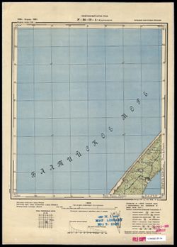
- Description:
- 1910
- Subject:
- Geographic Subject: Šilutė, Topical Subject: Maps, and Topical Subject: Soviet Union
- Publisher:
- Генеральный штаб РККА
- Language:
- Russian
- Identifier:
- VAC9619-000262
- Genre:
- Military Maps and Topographic Maps
- Geographic Location:
- Coordinates: 55.3333, 21.25, 55.5, 21.5
- Related URL:
- Download GeoTIFF: https://drive.google.com/open?id=1rxG4WZI499JuzU1uDuHrNkxcICYNNcF_ and Catalog URL: http://iucat.iu.edu/catalog/5020131
- Abstract:
- Modern area represented: Šilutė, Lithuania
- Call Number:
- G7000 s50 .S68 N-34-19-D
- City:
- Шиббэн (Szibben)
- Copyright Holder:
- No Copyright - United States
- Country:
- Германия (Germany)
- Physical Description:
- Scale: 1:50,000
- Persistent URL:
- http://purl.dlib.indiana.edu/iudl/images/VAC9619/VAC9619-000262
- Provenance:
- DMA Topographic Center, Army Map Service Library, OMAHA, Library of Congress Geography & Map Division
-
- Description:
- 1910
- Subject:
- Geographic Subject: Stankiškiai, Topical Subject: Maps, and Topical Subject: Soviet Union
- Publisher:
- Генеральный штаб РККА
- Language:
- Russian
- Identifier:
- VAC9619-000260
- Genre:
- Topographic Maps and Military Maps
- Geographic Location:
- Coordinates: 55.3333, 21, 55.5, 21.25
- Related URL:
- Catalog URL: http://iucat.iu.edu/catalog/5020131 and Download GeoTIFF: https://drive.google.com/open?id=1uJDoHtLa9wu3Mr1ekBE-DNRBvaSVgGef
- Abstract:
- Modern area represented: Stankiškiai, Lithuania
- Call Number:
- G7000 s50 .S68 N-34-19-C
- City:
- Станкишкен (Stankischken)
- Copyright Holder:
- No Copyright - United States
- Country:
- Германия (Germany)
- Physical Description:
- Scale: 1:50,000
- Persistent URL:
- http://purl.dlib.indiana.edu/iudl/images/VAC9619/VAC9619-000260
- Provenance:
- DMA Topographic Center, Army Map Service Library, OMAHA, Library of Congress Geography & Map Division
-
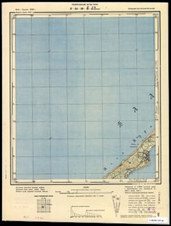
- Subject:
- Topical Subject: Maps, Geographic Subject: Priekulė, and Topical Subject: Soviet Union
- Publisher:
- Генеральный штаб РККА
- Language:
- Russian
- Date Created:
- 1910
- Identifier:
- VAC9619-000259
- Genre:
- Military Maps and Topographic Maps
- Geographic Location:
- Coordinates: 55.5, 21.25, 55.6667, 21.5
- Related URL:
- Download GeoTIFF: https://drive.google.com/open?id=1b6hSEJboidU6Eavc6er46IfWXzeHn2sW and Catalog URL: http://iucat.iu.edu/catalog/5020131
- Abstract:
- Modern area represented: Priekulė, Lithuania
- Call Number:
- G7000 s50 .S68 N-34-19-B
- City:
- Прэкульс (Prökuls)
- Copyright Holder:
- No Copyright - United States
- Country:
- Германия (Germany) and Литва (Lithuania)
- Physical Description:
- Scale: 1:50,000
- Persistent URL:
- http://purl.dlib.indiana.edu/iudl/images/VAC9619/VAC9619-000259
- Provenance:
- DMA Topographic Center, Army Map Service Library, OMAHA, Library of Congress Geography & Map Division
-
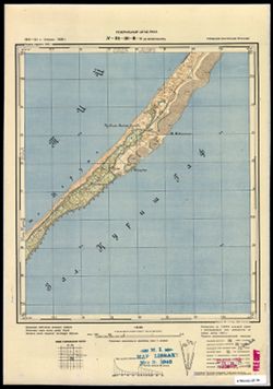
- Description:
- 1910
- Subject:
- Topical Subject: Soviet Union, Geographic Subject: Juodkrantė, and Topical Subject: Maps
- Publisher:
- Генеральный штаб РККА
- Language:
- Russian
- Identifier:
- VAC9619-000258
- Genre:
- Topographic Maps and Military Maps
- Geographic Location:
- Coordinates: 55.5, 21, 55.667, 21.25
- Related URL:
- Catalog URL: http://iucat.iu.edu/catalog/5020131 and Download GeoTIFF: https://drive.google.com/open?id=1AWP1js8JX-nmEdgJTK1Vyh4m6bcGLhnA
- Abstract:
- Modern area represented: Juodkrantė, Lithuania
- Call Number:
- G7000 s50 .S68 N-34-19-A
- City:
- Шварцорт (Schwarzort)
- Copyright Holder:
- No Copyright - United States
- Country:
- Германия (Germany)
- Physical Description:
- Scale: 1:50,000
- Persistent URL:
- http://purl.dlib.indiana.edu/iudl/images/VAC9619/VAC9619-000258
- Provenance:
- DMA Topographic Center, Army Map Service Library, OMAHA, Library of Congress Geography & Map Division
-
- Subject:
- Topical Subject: Soviet Union, Topical Subject: Maps, and Geographic Subject: Gargždai
- Publisher:
- Генеральный штаб РККА
- Language:
- Russian
- Identifier:
- VAC9619-000246
- Genre:
- Topographic Maps and Military Maps
- Geographic Location:
- Coordinates: 55.6667, 21.25, 55.8333, 21.5
- Related URL:
- Catalog URL: http://iucat.iu.edu/catalog/5020131 and Download GeoTIFF: https://drive.google.com/open?id=1W1wbSeGiv4-qsQjlMXpAVJb04cHI0HMj
- Abstract:
- Modern area represented: Gargždai, Lithuania
- Call Number:
- G7000 s50 .S68 N-34-7-D
- City:
- Гаргждай (Gargždai)
- Copyright Holder:
- No Copyright - United States
- Country:
- Литва (Lithuania) and Германия (Germany)
- Physical Description:
- Scale: 1:50,000
- Persistent URL:
- http://purl.dlib.indiana.edu/iudl/images/VAC9619/VAC9619-000246
- Provenance:
- DMA Topographic Center, Army Map Service Library, Library of Congress Geography & Map Division
-
- Subject:
- Topical Subject: Soviet Union, Geographic Subject: Kartena, and Topical Subject: Maps
- Publisher:
- Генеральный штаб РККА
- Language:
- Russian
- Identifier:
- VAC9619-000245
- Genre:
- Military Maps and Topographic Maps
- Geographic Location:
- Coordinates: 55.8333, 21.25, 56, 21.5
- Related URL:
- Catalog URL: http://iucat.iu.edu/catalog/5020131 and Download GeoTIFF: https://drive.google.com/open?id=1wmN_QXUcqaRGMQc88Msf-u2di8f9xgOi
- Abstract:
- Modern area represented: Kartena, Lithuania.
- Call Number:
- G7000 s50 .S68 sheet N-34-7-B
- City:
- Картена (Kartena)
- Copyright Holder:
- No Copyright - United States
- Country:
- Германия (Germany) and Литва (Lithuania)
- Physical Description:
- Scale: 1:50,000
- Persistent URL:
- http://purl.dlib.indiana.edu/iudl/images/VAC9619/VAC9619-000245
- Provenance:
- DMA Topographic Center, Army Map Service Library, Library of Congress Geography & Map Division
