
Search Constraints
You searched for:
Campus
IUB
Remove constraint Campus: IUB
Country
Область государственных интересов Германии (Region of German state interest)
Remove constraint Country: Область государственных интересов Германии (Region of German state interest)
Holding Location
B-WELLS
Remove constraint Holding Location: B-WELLS
Collections
Russian Military Topographic Map Collection
Remove constraint Collections: Russian Military Topographic Map Collection
« Previous |
1 - 20 of 92
|
Next »
Search Results
-
- Subject:
- Topical Subject: Soviet Union, Geographic Subject: Myszyniec, and Topical Subject: Maps
- Publisher:
- Генеральный штаб Красной Армии
- Language:
- Russian
- Date Created:
- 1941
- Identifier:
- VAC9619-000367
- Genre:
- Topographic Maps and Military Maps
- Geographic Location:
- Coordinates: 53.3333, 21.25, 53.5, 21.5
- Related URL:
- Catalog URL: http://iucat.iu.edu/catalog/5020131 and Download GeoTIFF: https://drive.google.com/open?id=1FYXXnu6YQ3Mr7ySKdf7m7E2v6f7ARySH
- Abstract:
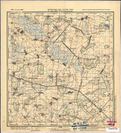
- Modern area represented: Myszyniec, Poland
- Call Number:
- G7000 s50 .S68 sheet N-34-91-D
- Caption:
- Captured map
- City:
- Мышинец (Myszyniec)
- Copyright Holder:
- No Copyright - United States
- Country:
- Германия (Germany), Область государственных интересов Германии (Region of German state interest), and Восточная Пруссия (East Prussia)
- Physical Description:
- Scale: 1:50,000
- Persistent URL:
- http://purl.dlib.indiana.edu/iudl/images/VAC9619/VAC9619-000367
- Provenance:
- DMA Topographic Center, Army Map Service Library, Library of Congress Geography & Map Division
-
- Subject:
- Topical Subject: Maps, Geographic Subject: Dubowo Pierwsze, and Topical Subject: Soviet Union
- Publisher:
- Генеральный штаб Красной Армии
- Language:
- Russian
- Date Created:
- 1941
- Identifier:
- VAC9619-003826
- Genre:
- Topographic Maps and Military Maps
- Geographic Location:
- Coordinates: 54, 22.875, 54.083, 23
- Related URL:
- Download GeoTIFF: https://drive.google.com/file/d/14r-fQyH7mOY4p-2FsBrew0kTqdalqLS9/view?usp=sharing and Catalog URL: https://iucat.iu.edu/catalog/14701157
- Abstract:
- Modern area represented: Dubowo Pierwsze, Poland
- Call Number:
- G7063.K2 s25 .S6 sheet N-34-70-D-d
- City:
- Дубово 1-ое (Dubowo Pierwsze)
- Copyright Holder:
- No Copyright - United States
- Country:
- Область государственных интересов Германии (Region of German state interest)
- Physical Description:
- Scale: 1:25,000
- Persistent URL:
- http://purl.dlib.indiana.edu/iudl/images/VAC9619/VAC9619-003826
- Provenance:
- Army Map Service Library, OMAHA, Library of Congress Geography & Map Division
-
- Subject:
- Geographic Subject: Bakaniuk, Topical Subject: Maps, and Topical Subject: Soviet Union
- Publisher:
- Генеральный штаб Красной Армии
- Language:
- Russian
- Date Created:
- 1941
- Identifier:
- VAC9619-003825
- Genre:
- Military Maps and Topographic Maps
- Geographic Location:
- Coordinates: 54, 22.75, 54.083, 22.875
- Related URL:
- Download GeoTIFF: https://drive.google.com/file/d/1xrp9zpQVNPo6Yk3_6uuukgaLUlWAn_hf/view?usp=sharing and Catalog URL: https://iucat.iu.edu/catalog/14701157
- Abstract:
- Modern area represented: Bakaniuk, Poland
- Call Number:
- G7063.K2 s25 .S6 sheet N-34-70-D-b
- City:
- Баканюк (Bakaniuk)
- Copyright Holder:
- No Copyright - United States
- Country:
- Область государственных интересов Германии (Region of German state interest)
- Physical Description:
- Scale: 1:25,000
- Persistent URL:
- http://purl.dlib.indiana.edu/iudl/images/VAC9619/VAC9619-003825
- Provenance:
- Army Map Service Library, Library of Congress Geography & Map Division
-
- Subject:
- Topical Subject: Maps, Geographic Subject: Suwałki, and Topical Subject: Soviet Union
- Publisher:
- Генеральный штаб Красной Армии
- Language:
- Russian
- Date Created:
- 1941
- Identifier:
- VAC9619-003824
- Genre:
- Topographic Maps and Military Maps
- Geographic Location:
- Coordinates: 54.083, 22.875, 54.167, 23
- Related URL:
- Download GeoTIFF: https://drive.google.com/file/d/19dVJ3F5H_AziY1NXhM1Qg4ANEdqxp6P6/view?usp=sharing and Catalog URL: https://iucat.iu.edu/catalog/14701157
- Abstract:
- Modern area represented: Suwałki, Poland
- Call Number:
- G7063.K2 s25 .S6 sheet N-34-70-D-b
- City:
- Сувалки (Suwałki)
- Copyright Holder:
- No Copyright - United States
- Country:
- Область государственных интересов Германии (Region of German state interest)
- Physical Description:
- Scale: 1:25,000
- Persistent URL:
- http://purl.dlib.indiana.edu/iudl/images/VAC9619/VAC9619-003824
- Provenance:
- Army Map Service Library, Library of Congress Geography & Map Division
-
- Subject:
- Geographic Subject: Olecko, Topical Subject: Soviet Union, and Topical Subject: Maps
- Publisher:
- Генеральный штаб Красной Армии
- Language:
- Russian
- Date Created:
- 1941
- Identifier:
- VAC9619-000354
- Genre:
- Topographic Maps and Military Maps
- Geographic Location:
- Coordinates: 54.0, 22.5, 54.166667, 22.75
- Related URL:
- Download GeoTIFF: https://drive.google.com/open?id=1WNDxDhKCEjUwfDRkE1jGhIeQso3c6ZO4 and Catalog URL: http://iucat.iu.edu/catalog/5020131
- Abstract:
- Modern area represented: Olecko, Poland
- Call Number:
- G7000 s50 .S68 sheet N-34-70-C
- City:
- Тройбург (Treuburg)
- Copyright Holder:
- No Copyright - United States
- Country:
- Область государственных интересов Германии (Region of German state interest) and Германия (Germany)
- Physical Description:
- Scale: 1:50,000
- Persistent URL:
- http://purl.dlib.indiana.edu/iudl/images/VAC9619/VAC9619-000354
- Provenance:
- DMA Topographic Center, Army Map Service Library, Library of Congress Geography & Map Division
-
- Subject:
- Geographic Subject: Jeleniewo, Topical Subject: Soviet Union, and Topical Subject: Maps
- Publisher:
- Генеральный штаб Красной Армии
- Language:
- Russian
- Date Created:
- 1941
- Identifier:
- VAC9619-003823
- Genre:
- Topographic Maps and Military Maps
- Geographic Location:
- Coordinates: 54.167, 22.875, 54.25, 23
- Related URL:
- Catalog URL: https://iucat.iu.edu/catalog/14701157 and Download GeoTIFF: https://drive.google.com/file/d/1IEXOWeBs29cvuQxpP53jjDmEVm_UF20C/view?usp=sharing
- Abstract:
- Modern area represented: Jeleniewo, Poland
- Call Number:
- G7063.K2 s25 .S6 sheet N-34-70-B-d
- City:
- Еленево (Jeleniewo)
- Copyright Holder:
- No Copyright - United States
- Country:
- Область государственных интересов Германии (Region of German state interest)
- Physical Description:
- Scale: 1:25,000
- Persistent URL:
- http://purl.dlib.indiana.edu/iudl/images/VAC9619/VAC9619-003823
- Provenance:
- Army Map Service Library, OMAHA, Library of Congress Geography & Map Division
-
- Subject:
- Topical Subject: Maps, Topical Subject: Soviet Union, and Geographic Subject: Pawłówka
- Publisher:
- Генеральный штаб Красной Армии
- Language:
- Russian
- Date Created:
- 1941
- Identifier:
- VAC9619-003822
- Genre:
- Military Maps and Topographic Maps
- Geographic Location:
- Coordinates: 54.167, 22.75, 54.25, 22.875
- Related URL:
- Catalog URL: https://iucat.iu.edu/catalog/14701157 and Download GeoTIFF: https://drive.google.com/file/d/1WRVcmyICQCx4nadbxhYZPXA6F1g-zvXj/view?usp=sharing
- Abstract:
- Modern area represented: Nowa Pawłówka and Stara Pawłówka, Poland
- Call Number:
- G7063.K2 s25 .S6 sheet N-34-70-B-c
- City:
- Павлувка (Pawłówka)
- Copyright Holder:
- No Copyright - United States
- Country:
- Область государственных интересов Германии (Region of German state interest)
- Physical Description:
- Scale: 1:25,000
- Persistent URL:
- http://purl.dlib.indiana.edu/iudl/images/VAC9619/VAC9619-003822
- Provenance:
- Army Map Service Library, OMAHA, Library of Congress Geography & Map Division
-
- Subject:
- Topical Subject: Maps, Topical Subject: Soviet Union, and Geographic Subject: Jałowo
- Publisher:
- Генеральный штаб Красной Армии
- Language:
- Russian
- Date Created:
- 1941
- Identifier:
- VAC9619-003821
- Genre:
- Military Maps and Topographic Maps
- Geographic Location:
- Coordinates: 54.25, 22.875, 54.333, 23
- Related URL:
- Download GeoTIFF: https://drive.google.com/file/d/1GBaO0vMThg3_tdSZzuUftYilS4-ltNo6/view?usp=sharing and Catalog URL: https://iucat.iu.edu/catalog/14701157
- Abstract:
- Modern area represented: Jałowo, Poland
- Call Number:
- G7063.K2 s25 .S6 sheet N-34-70-B-b
- City:
- Ялово (Jałowo)
- Copyright Holder:
- No Copyright - United States
- Country:
- Область государственных интересов Германии (Region of German state interest)
- Physical Description:
- Scale: 1:25,000
- Persistent URL:
- http://purl.dlib.indiana.edu/iudl/images/VAC9619/VAC9619-003821
- Provenance:
- DMA Topographic Center, Army Map Service Library, Library of Congress Geography & Map Division
-
- Subject:
- Geographic Subject: Hańcza, Topical Subject: Soviet Union, and Topical Subject: Maps
- Publisher:
- Генеральный штаб Красной Армии
- Language:
- Russian
- Date Created:
- 1941
- Identifier:
- VAC9619-003820
- Genre:
- Military Maps and Topographic Maps
- Geographic Location:
- Coordinates: 54.25, 22.75, 54.333, 22.875
- Related URL:
- Download GeoTIFF: https://drive.google.com/file/d/1th8Iaf_12VIyaDIU0NaPb09nIh7q0PuH/view?usp=sharing and Catalog URL: https://iucat.iu.edu/catalog/14701157
- Abstract:
- Modern area represented: Hańcza, Poland
- Call Number:
- G7063.K2 s25 .S6 sheet N-34-70-B-а
- City:
- Ганьча (Hańcza)
- Copyright Holder:
- No Copyright - United States
- Country:
- Область государственных интересов Германии (Region of German state interest) and Германия (Восточная Пруссия) (Germany (East Prussia))
- Physical Description:
- Scale: 1:25,000
- Persistent URL:
- http://purl.dlib.indiana.edu/iudl/images/VAC9619/VAC9619-003820
- Provenance:
- Army Map Service Library, OMAHA, Library of Congress Geography & Map Division
-
- Subject:
- Geographic Subject: Filipów, Topical Subject: Maps, and Topical Subject: Soviet Union
- Publisher:
- Генеральный штаб Красной Армии
- Language:
- Russian
- Date Created:
- 1941
- Identifier:
- VAC9619-003819
- Genre:
- Military Maps and Topographic Maps
- Geographic Location:
- Coordinates: 54.167, 22.5, 54.25, 22.625
- Related URL:
- Catalog URL: https://iucat.iu.edu/catalog/14701157 and Download GeoTIFF: https://drive.google.com/file/d/1ILUQo4m31FibY21pBMZLAlj5SkpI7Y4W/view?usp=sharing
- Abstract:
- Modern area represented: Filipów, Poland
- Call Number:
- G7063.K2 s25 .S6 sheet N-34-70-A-c
- City:
- Филипув (Filipów)
- Copyright Holder:
- No Copyright - United States
- Country:
- Германия (Восточная Пруссия) (Germany (East Prussia)) and Область государственных интересов Германии (Region of German state interest)
- Physical Description:
- Scale: 1:25,000
- Persistent URL:
- http://purl.dlib.indiana.edu/iudl/images/VAC9619/VAC9619-003819
- Provenance:
- Army Map Service Library, Library of Congress Geography & Map Division
-
- Subject:
- Topical Subject: Maps, Geographic Subject: Dubeninki, and Topical Subject: Soviet Union
- Publisher:
- Генеральный штаб Красной Армии
- Language:
- Russian
- Date Created:
- 1941
- Identifier:
- VAC9619-003818
- Genre:
- Topographic Maps and Military Maps
- Geographic Location:
- Coordinates: 54.25, 22.5, 54.333, 22.625
- Related URL:
- Catalog URL: https://iucat.iu.edu/catalog/14701157 and Download GeoTIFF: https://drive.google.com/file/d/19AcnhuhWm1XPNSHbDJOLdHiW_ecq-eVm/view?usp=sharing
- Abstract:
- Modern area represented: Dubeninki, Poland
- Call Number:
- G7063.K2 s25 .S6 sheet N-34-70-A-а
- City:
- Дубенингкен (Dubeningken)
- Copyright Holder:
- No Copyright - United States
- Country:
- Область государственных интересов Германии (Region of German state interest) and Германия (Восточная Пруссия) (Germany (East Prussia))
- Physical Description:
- Scale: 1:25,000
- Persistent URL:
- http://purl.dlib.indiana.edu/iudl/images/VAC9619/VAC9619-003818
- Provenance:
- Army Map Service Library, OMAHA, Library of Congress Geography & Map Division
-

- Subject:
- Geographic Subject: Biała Podlaska, Topical Subject: Soviet Union, and Topical Subject: Maps
- Publisher:
- Генеральный штаб Красной Армии
- Language:
- Russian
- Date Created:
- 1941
- Identifier:
- VAC9619-000386
- Genre:
- Topographic Maps and Military Maps
- Geographic Location:
- Coordinates: 52, 23, 52.1667, 23.25
- Related URL:
- Catalog URL: http://iucat.iu.edu/catalog/5020131 and Download GeoTIFF: https://drive.google.com/open?id=1j9Jb2zoApXKgz_weAAHXPhklR1FYCcmb
- Abstract:
- Modern area represented: Biała Podlaska, Poland
- Call Number:
- G7000 s50 .S68 sheet N-34-143-C
- City:
- Бяла Подляска (Biała Podlaska)
- Copyright Holder:
- No Copyright - United States
- Country:
- Область государственных интересов Германии (Region of German state interest)
- Physical Description:
- Scale: 1:50,000
- Persistent URL:
- http://purl.dlib.indiana.edu/iudl/images/VAC9619/VAC9619-000386
- Provenance:
- Army Map Service Library, OMAHA, Library of Congress Geography & Map Division
-
- Subject:
- Topical Subject: Soviet Union, Topical Subject: Maps, and Geographic Subject: Swory
- Publisher:
- Генеральный штаб Красной Армии
- Language:
- Russian
- Date Created:
- 1941
- Identifier:
- VAC9619-000385
- Genre:
- Military Maps and Topographic Maps
- Geographic Location:
- Coordinates: 52, 22.75, 52.1667, 23
- Related URL:
- Catalog URL: http://iucat.iu.edu/catalog/5020131 and Download GeoTIFF: https://drive.google.com/open?id=1iNjieZDdXL0iSAoQGAtrxugHpn_AdCxr
- Abstract:
- Modern area represented: Swory, Poland
- Call Number:
- G7000 s50 .S68 sheet N-34-142-D
- Caption:
- Captured map
- City:
- Своры (Swory)
- Copyright Holder:
- No Copyright - United States
- Country:
- Область государственных интересов Германии (Region of German state interest)
- Physical Description:
- Scale: 1:50,000
- Persistent URL:
- http://purl.dlib.indiana.edu/iudl/images/VAC9619/VAC9619-000385
- Provenance:
- DMA Topographic Center, Army Map Service Library, OMAHA, Library of Congress Geography & Map Division
-
- Subject:
- Topical Subject: Maps, Geographic Subject: Krzesk-Królowa Niwa, and Topical Subject: Soviet Union
- Publisher:
- Генеральный штаб Красной Армии
- Language:
- Russian
- Date Created:
- 1941
- Identifier:
- VAC9619-000384
- Genre:
- Military Maps and Topographic Maps
- Geographic Location:
- Coordinates: 52, 22.5, 52.1667, 22.75
- Related URL:
- Download GeoTIFF: https://drive.google.com/open?id=1KYJIh1i1xu4izSRnuaaX2KkyP1Uky8SL and Catalog URL: http://iucat.iu.edu/catalog/5020131
- Abstract:
- Modern area represented: Krzesk-Królowa Niwa, Poland
- Call Number:
- G7000 s50 .S68 sheet N-34-142-C
- City:
- Кшеск-Крулева Нива (Krzesk-Królowa Niwa)
- Copyright Holder:
- No Copyright - United States
- Country:
- Область государственных интересов Германии (Region of German state interest)
- Physical Description:
- Scale: 1:50,000
- Persistent URL:
- http://purl.dlib.indiana.edu/iudl/images/VAC9619/VAC9619-000384
- Provenance:
- M. I. Map Library, G000-30
-
- Subject:
- Geographic Subject: Pruszyn, Topical Subject: Maps, and Topical Subject: Soviet Union
- Publisher:
- Генеральный штаб Красной Армии
- Language:
- Russian
- Date Created:
- 1941
- Identifier:
- VAC9619-000382
- Genre:
- Military Maps and Topographic Maps
- Geographic Location:
- Coordinates: 52.1667, 22.25, 52.3333, 22.5
- Related URL:
- Download GeoTIFF: https://drive.google.com/open?id=15b5hrAJ9da_wcemnEC0AhFb8-lwLrq4y and Catalog URL: http://iucat.iu.edu/catalog/5020131
- Abstract:
- Modern area represented: Pruszyn, Poland
- Call Number:
- G7000 s50 .S68 sheet N-34-141-B
- Caption:
- Captured map
- City:
- Прушин (Pruszyn)
- Copyright Holder:
- No Copyright - United States
- Country:
- Область государственных интересов Германии (Region of German state interest)
- Physical Description:
- Scale: 1:50,000
- Persistent URL:
- http://purl.dlib.indiana.edu/iudl/images/VAC9619/VAC9619-000382
- Provenance:
- Army Map Service Library, OMAHA, Library of Congress Geography & Map Division
-
- Subject:
- Topical Subject: Maps, Topical Subject: Soviet Union, and Geographic Subject: Mokobody
- Publisher:
- Генеральный штаб Красной Армии
- Language:
- Russian
- Date Created:
- 1941
- Identifier:
- VAC9619-000381
- Genre:
- Topographic Maps and Military Maps
- Geographic Location:
- Coordinates: 52.1667, 22, 52.3333, 22.25
- Related URL:
- Catalog URL: http://iucat.iu.edu/catalog/5020131 and Download GeoTIFF: https://drive.google.com/open?id=1ouJ804ACOTOR3T2kEqiiASXr2R4REZAh
- Abstract:
- Modern area represented: Mokobody, Poland
- Call Number:
- G7000 s50 .S68 sheet N-34-141-A
- Caption:
- Captured map
- City:
- Мокободы (Mokobody)
- Copyright Holder:
- No Copyright - United States
- Country:
- Область государственных интересов Германии (Region of German state interest)
- Physical Description:
- Scale: 1:50,000
- Persistent URL:
- http://purl.dlib.indiana.edu/iudl/images/VAC9619/VAC9619-000381
- Provenance:
- Army Map Service Library, OMAHA, Library of Congress Geography & Map Division
-
- Subject:
- Geographic Subject: Latowicz, Topical Subject: Soviet Union, and Topical Subject: Maps
- Publisher:
- Генеральный штаб Красной Армии
- Language:
- Russian
- Date Created:
- 1941
- Identifier:
- VAC9619-000340
- Genre:
- Topographic Maps and Military Maps
- Geographic Location:
- Coordinates: 52.0, 21.75, 52.166667, 22.0
- Related URL:
- Download GeoTIFF: https://drive.google.com/open?id=1ifVCloGvj7k8gskS3r87hxY43z_qtROX and Catalog URL: http://iucat.iu.edu/catalog/5020131
- Abstract:
- Modern area represented: Latowicz, Poland
- Call Number:
- G7000 s50 .S68 sheet N-34-140-D
- Caption:
- Captured map
- City:
- Лятович (Latowicz)
- Copyright Holder:
- No Copyright - United States
- Country:
- Область государственных интересов Германии (Region of German state interest)
- Physical Description:
- Scale: 1:50,000
- Persistent URL:
- http://purl.dlib.indiana.edu/iudl/images/VAC9619/VAC9619-000340
- Provenance:
- Army Map Service Library, OMAHA, Library of Congress Geography & Map Division
-
- Subject:
- Geographic Subject: Cegłów, Topical Subject: Soviet Union, and Topical Subject: Maps
- Publisher:
- Генеральный штаб Красной Армии
- Language:
- Russian
- Date Created:
- 1941
- Identifier:
- VAC9619-000336
- Genre:
- Military Maps and Topographic Maps
- Geographic Location:
- Coordinates: 52, 21.5, 52.167, 21.75
- Related URL:
- Download GeoTIFF: https://drive.google.com/open?id=1EwlXwAYp5zAgkg8DJ__OMlHFwctYLxzf and Catalog URL: http://iucat.iu.edu/catalog/5020131
- Abstract:
- Modern area represented: Cegłów, Poland
- Call Number:
- G7000 s50 .S68 sheet N-34-140-C
- Caption:
- Captured map
- City:
- Цеглув (Cegłów)
- Copyright Holder:
- No Copyright - United States
- Country:
- Область государственных интересов Германии (Region of German state interest)
- Physical Description:
- Scale: 1:50,000
- Persistent URL:
- http://purl.dlib.indiana.edu/iudl/images/VAC9619/VAC9619-000336
- Provenance:
- Army Map Service Library, OMAHA, Library of Congress Geography & Map Division
-
- Subject:
- Topical Subject: Soviet Union, Topical Subject: Maps, and Geographic Subject: Kałuszyn
- Publisher:
- Генеральный штаб Красной Армии
- Language:
- Russian
- Date Created:
- 1941
- Identifier:
- VAC9619-000335
- Genre:
- Military Maps and Topographic Maps
- Geographic Location:
- Coordinates: 52.166667, 21.75, 52.333333, 22.0
- Related URL:
- Download GeoTIFF: https://drive.google.com/open?id=1Sb-EziIgk9d7S9DVnzeYYee0wU_oK9Q9 and Catalog URL: http://iucat.iu.edu/catalog/5020131
- Abstract:
- Modern area represented: Kałuszyn, Poland
- Call Number:
- G7000 s50 .S68 sheet N-34-140-B
- Caption:
- Captured map
- City:
- Калушин (Kałuszyn)
- Copyright Holder:
- No Copyright - United States
- Country:
- Область государственных интересов Германии (Region of German state interest)
- Physical Description:
- Scale: 1:50,000
- Persistent URL:
- http://purl.dlib.indiana.edu/iudl/images/VAC9619/VAC9619-000335
- Provenance:
- Army Map Service Library, OMAHA, Library of Congress Geography & Map Division
-
- Subject:
- Geographic Subject: Otwock, Topical Subject: Maps, and Topical Subject: Soviet Union
- Publisher:
- Генеральный штаб Красной Армии
- Language:
- Russian
- Date Created:
- 1941
- Identifier:
- VAC9619-000334
- Genre:
- Military Maps and Topographic Maps
- Geographic Location:
- Coordinates: 52.0, 21.25, 52.166667, 21.5
- Related URL:
- Download GeoTIFF: https://drive.google.com/open?id=1tzxGHRI-6ocIi24fLP8Jt-gY1ypldrg9 and Catalog URL: http://iucat.iu.edu/catalog/5020131
- Abstract:
- Modern area represented: Otwock, Poland
- Call Number:
- G7000 s50 .S68 sheet N-34-139-D
- Caption:
- Captured map
- City:
- Отвоцк (Otwock)
- Copyright Holder:
- No Copyright - United States
- Country:
- Область государственных интересов Германии (Region of German state interest)
- Physical Description:
- Scale: 1:50,000
- Persistent URL:
- http://purl.dlib.indiana.edu/iudl/images/VAC9619/VAC9619-000334
- Provenance:
- Army Map Service Library, OMAHA, Library of Congress Geography & Map Division
