
Search Constraints
You searched for:
Campus
IUB
Remove constraint Campus: IUB
Country
СССР (USSR)
Remove constraint Country: СССР (USSR)
Pages
0-99 pages
Remove constraint Pages: 0-99 pages
Provenance
DMA Topographic Center, Army Map Service Library
Remove constraint Provenance: DMA Topographic Center, Army Map Service Library
« Previous |
1 - 100 of 147
|
Next »
Search Results
-
- Description:
- 1927
- Subject:
- Topical Subject: Maps, Geographic Subject: Tyntsy, and Topical Subject: Soviet Union
- Publisher:
- Управление военных топографов РККА
- Language:
- Russian
- Identifier:
- VAC9619-002272
- Genre:
- Military Maps and Topographic Maps
- Geographic Location:
- Coordinates: 56.3333, 40.5, 56.6667, 41
- Related URL:
- Download GeoTIFF: https://drive.google.com/file/d/102D4vu1uG3HlLnspP2zmEKvXMZnMEkAk/view?usp=sharing and Catalog URL: https://iucat.iu.edu/catalog/5020129
- Abstract:
- Modern area represented: Тынцы (Tyntsy), Vladimirskaya oblast, Russia
- Call Number:
- G7000 s100 .S7 sheet O-37-130
- City:
- Тынцы (Tyntsy)
- Copyright Holder:
- No Copyright - United States
- Country:
- СССР (USSR)
- State/Province:
- РСФСР (RSFSR) and Ивановская область (Ivanovo oblast)
- Physical Description:
- Scale: 1:100,000
- Persistent URL:
- http://purl.dlib.indiana.edu/iudl/images/VAC9619/VAC9619-002272
- Provenance:
- DMA Topographic Center, Army Map Service Library
-

- Description:
- 1926
- Subject:
- Topical Subject: Soviet Union, Geographic Subject: Sirotskiy, and Topical Subject: Maps
- Publisher:
- Генеральный штаб Красной Армии
- Language:
- Russian
- Date Created:
- 1941
- Identifier:
- VAC9619-002461
- Genre:
- Military Maps and Topographic Maps
- Geographic Location:
- Coordinates: 47, 43, 47.333, 43.5
- Related URL:
- Download GeoTIFF: https://drive.google.com/file/d/1lKyxlwfueH8iSqR8tLrAkEEVeuu5mIWT/view?usp=sharing and Catalog URL: https://iucat.iu.edu/catalog/5020129
- Abstract:
- Modern area represented: Sirotskiy, Russia
- Call Number:
- G7000 s100 .S7 sheet L-38-27
- Caption:
- Для служебного пользования
- City:
- Сиротский (Sirotskiy)
- Copyright Holder:
- No Copyright - United States
- Country:
- СССР (USSR)
- State/Province:
- РСФСР (RSFSR) and Ростовская область (Rostov oblast)
- Physical Description:
- Scale: 1:100,000
- Persistent URL:
- http://purl.dlib.indiana.edu/iudl/images/VAC9619/VAC9619-002461
- Provenance:
- DMA Topographic Center, Army Map Service Library
-

- Description:
- 1935
- Subject:
- Topical Subject: Soviet Union, Geographic Subject: Dagestan, Topical Subject: Maps, and Geographic Subject: Chubutla
- Publisher:
- Генеральный штаб Красной Армии
- Language:
- Russian
- Date Created:
- 1942
- Identifier:
- VAC9619-002249
- Genre:
- Topographic Maps and Military Maps
- Geographic Location:
- Coordinates: 44, 46, 44.3333, 46.5
- Related URL:
- Catalog URL: https://iucat.iu.edu/catalog/5020129 and Download GeoTIFF: https://drive.google.com/file/d/1CtOJbTsOR2cKivui8A9rZyUndxVZuweF/view?usp=sharing
- Abstract:
- Modern area represented: Чубутла (Chubutla), Dagestan, Russia
- Call Number:
- G7000 s100 .S7 sheet L-38-141
- Caption:
- Для cлужебного пользования
- City:
- Аул-Чубутла (Aul-Chubutla)
- Copyright Holder:
- No Copyright - United States
- Country:
- СССР (USSR)
- State/Province:
- Кизлярский округ (Kizlyar district), РСФСР (RSFSR), and Орджоникидзевский край (Ordzhonikidze kray)
- Physical Description:
- Scale: 1:100,000
- Persistent URL:
- http://purl.dlib.indiana.edu/iudl/images/VAC9619/VAC9619-002249
- Provenance:
- DMA Topographic Center, Army Map Service Library
-

- Description:
- 1890
- Subject:
- Topical Subject: Maps, Geographic Subject: Merkinė, and Topical Subject: Soviet Union
- Publisher:
- Генеральный штаб Красной Армии
- Language:
- Russian
- Date Created:
- 1940
- Identifier:
- VAC9619-004062
- Genre:
- Military Maps and Topographic Maps
- Geographic Location:
- Coordinates: 54, 24, 54.333, 24.5
- Related URL:
- Download GeoTIFF: https://drive.google.com/file/d/1y93Q-evfnuFOv1Y5G5Dz9TqcZre99-Eq/view?usp=sharing and Catalog URL: https://iucat.iu.edu/catalog/5020129
- Abstract:
- Modern area represented: Merkinė, Lithuania
- Call Number:
- G7000 s100 .S7 sheet N-35-61
- Caption:
- Для служебного пользования
- City:
- Меречь (Merecz)
- Copyright Holder:
- No Copyright - United States
- Country:
- СССР (USSR)
- State/Province:
- Литовская ССР (Lithuanian Soviet Socialist Republic)
- Physical Description:
- Scale: 1:100,000
- Persistent URL:
- http://purl.dlib.indiana.edu/iudl/images/VAC9619/VAC9619-004062
- Provenance:
- DMA Topographic Center, Army Map Service Library
-
- Description:
- 1940
- Subject:
- Geographic Subject: Pavlovskaya, Topical Subject: Maps, and Topical Subject: Soviet Union
- Publisher:
- Генеральный штаб Красной Армии
- Language:
- Russian
- Date Created:
- 1941
- Identifier:
- VAC9619-002330
- Genre:
- Topographic Maps and Military Maps
- Geographic Location:
- Coordinates: 46, 39.5, 46.3333, 40
- Related URL:
- Download GeoTIFF: https://drive.google.com/file/d/1xbqEApJ5hSLMPVxfU-oodDof-dkkXh20/view?usp=sharing and Catalog URL: https://iucat.iu.edu/catalog/5020129
- Abstract:
- Modern area represented: Pavlovskaya, Russia
- Call Number:
- G7000 s100 .S7 sheet L-37-68
- Caption:
- Для служебного пользования
- City:
- Павловская (Pavlovskaya)
- Copyright Holder:
- No Copyright - United States
- Country:
- СССР (USSR)
- State/Province:
- Краснодарский край (Krasnodar kray) and РСФСР (RSFSR)
- Physical Description:
- Scale: 1:100,000
- Persistent URL:
- http://purl.dlib.indiana.edu/iudl/images/VAC9619/VAC9619-002330
- Provenance:
- DMA Topographic Center, Army Map Service Library
-
- Description:
- 1936
- Subject:
- Topical Subject: Maps, Geographic Subject: Stepnaya, and Topical Subject: Soviet Union
- Publisher:
- Главное управление геодезии и картографии при СНК СССР
- Language:
- Russian
- Date Created:
- 1941
- Identifier:
- VAC9619-002337
- Genre:
- Topographic Maps and Military Maps
- Geographic Location:
- Coordinates: 45.667, 38, 46, 38.5
- Related URL:
- Catalog URL: https://iucat.iu.edu/catalog/5020129 and Download GeoTIFF: https://drive.google.com/file/d/1JbpHtvnICqALvD_ZX180f74-4Ca2Qrxr/view?usp=sharing
- Abstract:
- Modern area represented: Stepnaya, Russia
- Call Number:
- G7000 s100 .S7 sheet L-37-77
- Caption:
- Для служебного пользования
- City:
- Степная (Stepnaya)
- Copyright Holder:
- No Copyright - United States
- Country:
- СССР (USSR)
- State/Province:
- Краснодарский край (Krasnodar kray) and РСФСР (RSFSR)
- Physical Description:
- Scale: 1:100,000
- Persistent URL:
- http://purl.dlib.indiana.edu/iudl/images/VAC9619/VAC9619-002337
- Provenance:
- DMA Topographic Center, Army Map Service Library
-

- Description:
- 1890
- Subject:
- Topical Subject: Soviet Union, Topical Subject: Maps, and Geographic Subject: Slonim
- Publisher:
- Генеральный штаб Красной Армии
- Language:
- Russian
- Date Created:
- 1940
- Identifier:
- VAC9619-004100
- Genre:
- Military Maps and Topographic Maps
- Geographic Location:
- Coordinates: 53, 25, 53.333, 25.5
- Related URL:
- Download GeoTIFF: https://drive.google.com/file/d/11uIlcuAi2jRjN2zbDtSfPdBrUot13QKy/view?usp=sharing and Catalog URL: https://iucat.iu.edu/catalog/5020129
- Abstract:
- Modern area represented: Slonim, Belarus
- Call Number:
- G7000 s100 .S7 sheet N-35-99
- City:
- Слоним (Slonim)
- Copyright Holder:
- No Copyright - United States
- Country:
- СССР (USSR)
- State/Province:
- Белорусская ССР (Byelorussian Soviet Socialist Republic) and Барановичская область (Baranavichy oblast)
- Physical Description:
- Scale: 1:100,000
- Persistent URL:
- http://purl.dlib.indiana.edu/iudl/images/VAC9619/VAC9619-004100
- Provenance:
- DMA Topographic Center, Army Map Service Library
-
- Description:
- 1936
- Subject:
- Topical Subject: Soviet Union, Topical Subject: Maps, and Geographic Subject: Svislach
- Publisher:
- Управление военных топографов РККА
- Language:
- Russian
- Identifier:
- VAC9619-004094
- Genre:
- Topographic Maps and Military Maps
- Geographic Location:
- Coordinates: 53.333, 28.5, 53.667, 29
- Related URL:
- Download GeoTIFF: https://drive.google.com/file/d/1wKKzZhgv9Dr2ahNLD1JmLpBLB1twGSqm/view?usp=sharing and Catalog URL: https://iucat.iu.edu/catalog/5020129
- Abstract:
- Modern area represented: Svislach, Belarus
- Call Number:
- G7000 s100 .S7 sheet N-35-94
- Caption:
- Не подлежит оглашению
- City:
- Свислочь (Svislach)
- Copyright Holder:
- No Copyright - United States
- Country:
- СССР (USSR)
- State/Province:
- Белорусская ССР (Byelorussian Soviet Socialist Republic)
- Physical Description:
- Scale: 1:100,000
- Persistent URL:
- http://purl.dlib.indiana.edu/iudl/images/VAC9619/VAC9619-004094
- Provenance:
- DMA Topographic Center, Army Map Service Library
-
- Description:
- 1940
- Subject:
- Topical Subject: Soviet Union, Geographic Subject: Leningradskaya, and Topical Subject: Maps
- Publisher:
- Генеральный штаб Красной Армии
- Language:
- Russian
- Date Created:
- 1941
- Identifier:
- VAC9619-002329
- Genre:
- Military Maps and Topographic Maps
- Geographic Location:
- Coordinates: 46, 39, 46.3333, 39.5
- Related URL:
- Download GeoTIFF: https://drive.google.com/file/d/1O9ZH2ptxPJJ9cDyD-JH5mXSQdZcyF-6n/view?usp=sharing and Catalog URL: https://iucat.iu.edu/catalog/5020129
- Abstract:
- Modern area represented: Leningradskaya, Russia
- Call Number:
- G7000 s100 .S7 sheet L-37-67
- Caption:
- Для служебного пользования
- City:
- Ленинградская (Leningradskaya)
- Copyright Holder:
- No Copyright - United States
- Country:
- СССР (USSR)
- State/Province:
- Краснодарский край (Krasnodar kray) and РСФСР (RSFSR)
- Physical Description:
- Scale: 1:100,000
- Persistent URL:
- http://purl.dlib.indiana.edu/iudl/images/VAC9619/VAC9619-002329
- Provenance:
- DMA Topographic Center, Army Map Service Library
-
- Description:
- 1927
- Subject:
- Topical Subject: Maps, Topical Subject: Soviet Union, and Geographic Subject: Zapadnaya Dvina
- Publisher:
- Генеральный штаб Красной Армии
- Language:
- Russian
- Date Created:
- 1941
- Identifier:
- VAC9619-002233
- Genre:
- Military Maps and Topographic Maps
- Geographic Location:
- Coordinates: 56, 32, 56.3333, 32.5
- Related URL:
- Catalog URL: https://iucat.iu.edu/catalog/5020129 and Download GeoTIFF: https://drive.google.com/file/d/1ilppakufLs2qQPDjQwcVhMDRRILKyH-b/view?usp=sharing
- Abstract:
- Modern area represented: Западная Двина (Zapadnaya Dvina), Tverskaya oblast, Russia
- Call Number:
- G7000 s100 .S7 sheet O-36-137
- Caption:
- Captured map
- City:
- Западная Двина (Zapadnaya Dvina)
- Copyright Holder:
- No Copyright - United States
- Country:
- СССР (USSR)
- State/Province:
- Калининская область (Kalinin oblast), Смоленская область (Smolensk oblast), and РСФСР (RSFSR)
- Physical Description:
- Scale: 1:100,000
- Persistent URL:
- http://purl.dlib.indiana.edu/iudl/images/VAC9619/VAC9619-002233
- Provenance:
- DMA Topographic Center, Army Map Service Library
-
- Description:
- 1938
- Subject:
- Topical Subject: Soviet Union, Geographic Subject: Zaraysk, and Topical Subject: Maps
- Publisher:
- Генеральный штаб Красной Армии
- Language:
- Russian
- Date Created:
- 1941
- Identifier:
- VAC9619-003102
- Genre:
- Military Maps and Topographic Maps
- Geographic Location:
- Coordinates: 54.667, 38.5, 55, 39
- Related URL:
- Catalog URL: https://iucat.iu.edu/catalog/5020129 and Download GeoTIFF: https://drive.google.com/file/d/1CmYyVQOnWjiCDq9ktmzhtJHliBIrO_dX/view?usp=sharing
- Abstract:
- Modern area represented: Zaraysk, Russia
- Call Number:
- G7000 s100 .S7 sheet N-37-42
- Caption:
- Для служебного пользования
- City:
- Зарайск (Zaraysk)
- Copyright Holder:
- No Copyright - United States
- Country:
- СССР (USSR)
- State/Province:
- Московская область (Moscow oblast) and РСФСР (RSFSR)
- Physical Description:
- Scale: 1:100,000
- Persistent URL:
- http://purl.dlib.indiana.edu/iudl/images/VAC9619/VAC9619-003102
- Provenance:
- DMA Topographic Center, Army Map Service Library
-
- Description:
- 1939
- Subject:
- Geographic Subject: Kamyzyak, Topical Subject: Maps, Topical Subject: Soviet Union, and Geographic Subject: Astrakhan Oblast
- Publisher:
- Наркомрыбпром Главрыбвод
- Language:
- Russian
- Date Created:
- 1940
- Identifier:
- VAC9619-002256
- Genre:
- Military Maps and Topographic Maps
- Geographic Location:
- Coordinates: 46, 48, 46.3333, 48.5
- Related URL:
- Catalog URL: https://iucat.iu.edu/catalog/5020129 and Download GeoTIFF: https://drive.google.com/file/d/1COuEZimX0zDKPsy-a9vlykqgrNjh2Jla/view?usp=sharing
- Abstract:
- Modern area represented: Камызяк (Kamyzyak), Astrakhan Oblast, Russia
- Call Number:
- G7000 s100 .S7 sheet L-39-61
- Caption:
- Рабочий оттиск. Бесплатно. Временное Издание. Для внутреннего использования.
- City:
- Камызяк (Kamyzyak)
- Copyright Holder:
- No Copyright - United States
- Country:
- СССР (USSR)
- State/Province:
- РСФСР (RSFSR) and Сталинградская область (Stalingrad oblast)
- Physical Description:
- Scale: 1:100,000
- Persistent URL:
- http://purl.dlib.indiana.edu/iudl/images/VAC9619/VAC9619-002256
- Provenance:
- DMA Topographic Center, Army Map Service Library
-
- Description:
- 1916
- Subject:
- Geographic Subject: Janowo, Topical Subject: Maps, and Topical Subject: Soviet Union
- Publisher:
- Генеральный штаб РККА
- Language:
- Russian
- Date Created:
- 1936
- Identifier:
- VAC9619-003959
- Genre:
- Topographic Maps and Military Maps
- Geographic Location:
- Coordinates: 53.333, 21.5, 53.667, 22
- Related URL:
- Catalog URL: https://iucat.iu.edu/catalog/5020129 and Download GeoTIFF: https://drive.google.com/file/d/1V9_BtRhfFGWhUMbvWGMSthlnHu_vi1pv/view?usp=sharing
- Abstract:
- Modern area represented: Janowo, Warmia-Masuria, Poland
- Call Number:
- G7000 s100 .S7 sheet N-34-92
- City:
- Иоганнисбург (Johannisberg)
- Copyright Holder:
- No Copyright - United States
- Country:
- СССР (USSR) and Германия (Germany)
- State/Province:
- Белорусская ССР (Byelorussian Soviet Socialist Republic), Область государственных интересов Германии (Region of German state interests), and Белостокская обл...
- Physical Description:
- Scale: 1:100,000
- Persistent URL:
- http://purl.dlib.indiana.edu/iudl/images/VAC9619/VAC9619-003959
- Provenance:
- DMA Topographic Center, Army Map Service Library
-
- Description:
- 1939
- Subject:
- Geographic Subject: Surovikino, Topical Subject: Soviet Union, and Topical Subject: Maps
- Publisher:
- Генеральный штаб Красной Армии
- Language:
- Russian
- Date Created:
- 1941
- Identifier:
- VAC9619-003434
- Genre:
- Military Maps and Topographic Maps
- Geographic Location:
- Coordinates: 48.333, 42.5, 48.667, 43
- Related URL:
- Download GeoTIFF: https://drive.google.com/file/d/1IklMCz8LqY7v79fI3kROuDDC6V5cGWZK/view?usp=sharing and Catalog URL: https://iucat.iu.edu/catalog/5020129
- Abstract:
- Modern area represented: Surovikino, Volgograd oblast, Russia
- Call Number:
- G7000 s100 .S7 sheet M-38-122
- Caption:
- Для служебного пользования
- City:
- Суровикино (Surovikino)
- Copyright Holder:
- No Copyright - United States
- Country:
- СССР (USSR)
- State/Province:
- Сталинградская область (Stalingrad oblast), РСФСР (RSFSR), and Ростовская область (Rostov oblast)
- Physical Description:
- Scale: 1:100,000
- Persistent URL:
- http://purl.dlib.indiana.edu/iudl/images/VAC9619/VAC9619-003434
- Provenance:
- DMA Topographic Center, Army Map Service Library
-
- Subject:
- Topical Subject: Soviet Union, Geographic Subject: Yaroslavl, and Topical Subject: Maps
- Publisher:
- Генеральный штаб Красной Армии
- Language:
- Russian
- Date Created:
- 1941
- Identifier:
- VAC9619-002239
- Genre:
- Topographic Maps and Military Maps
- Geographic Location:
- Coordinates: 57.3333, 39.5, 57.6667, 40
- Related URL:
- Catalog URL: https://iucat.iu.edu/catalog/5020129 and Download GeoTIFF: https://drive.google.com/file/d/1s1X2JX-UlHkHlKMosuECdWUBwvDsqFQ1/view?usp=sharing
- Abstract:
- Modern area represented: Yaroslavl, Yaroslavl oblast, Russia
- Call Number:
- G7000 s100 .S7 sheet O-37-92
- Caption:
- Для служебного пользования,Captured map
- City:
- Ярославль (Yaroslavl')
- Copyright Holder:
- No Copyright - United States
- Country:
- СССР (USSR)
- State/Province:
- Ярославская область (Yaroslavl oblast) and РСФСР (RSFSR)
- Physical Description:
- Scale: 1:100,000
- Persistent URL:
- http://purl.dlib.indiana.edu/iudl/images/VAC9619/VAC9619-002239
- Provenance:
- DMA Topographic Center, Army Map Service Library
-
- Description:
- 1925
- Subject:
- Topical Subject: Soviet Union, Topical Subject: Maps, and Geographic Subject: Severnaya
- Publisher:
- Геодезический комитет ВСНХ-СССР
- Language:
- Russian
- Date Created:
- 1927
- Identifier:
- VAC9619-002301
- Genre:
- Military Maps and Topographic Maps
- Geographic Location:
- Coordinates: 58, 60, 58.3333, 60.5
- Related URL:
- Download GeoTIFF: https://drive.google.com/file/d/1o_vAe_BRYbHzSAeCwHc6Fvpp9aaR2qCk/view?usp=sharing and Catalog URL: https://iucat.iu.edu/catalog/5020129
- Abstract:
- Currently: Sverdlovskaya oblast, Verkhnesaldinskij rayon
- Call Number:
- G7000 s100 .S7 sheet O-41-61
- City:
- Северная (Severnaya)
- Copyright Holder:
- No Copyright - United States
- Country:
- СССР (USSR)
- State/Province:
- Тагильский округ (Tagilsky district) and Уральская область (Ural oblast)
- Physical Description:
- Scale: 1:100,000
- Persistent URL:
- http://purl.dlib.indiana.edu/iudl/images/VAC9619/VAC9619-002301
- Provenance:
- DMA Topographic Center, Army Map Service Library
-
- Description:
- 1928
- Subject:
- Topical Subject: Soviet Union, Geographic Subject: Orlovskiy, and Topical Subject: Maps
- Publisher:
- Генеральный штаб Красной Армии
- Language:
- Russian
- Date Created:
- 1941
- Identifier:
- VAC9619-002467
- Genre:
- Topographic Maps and Military Maps
- Geographic Location:
- Coordinates: 46.667, 42, 47, 42.5
- Related URL:
- Download GeoTIFF: https://drive.google.com/file/d/1A5W_rrMYJa6yA7Ti1dQxHa_LjP1eK3E6/view?usp=sharing and Catalog URL: https://iucat.iu.edu/catalog/5020129
- Abstract:
- Modern area represented: Orlovskiy, Russia
- Call Number:
- G7000 s100 .S7 sheet L-38-37
- Caption:
- Для служебного пользования
- City:
- Орловская (Orlovskaya)
- Copyright Holder:
- No Copyright - United States
- Country:
- СССР (USSR)
- State/Province:
- Ростовская область (Rostov oblast) and РСФСР (RSFSR)
- Physical Description:
- Scale: 1:100,000
- Persistent URL:
- http://purl.dlib.indiana.edu/iudl/images/VAC9619/VAC9619-002467
- Provenance:
- DMA Topographic Center, Army Map Service Library
-
- Subject:
- Topical Subject: Maps, Topical Subject: Soviet Union, and Geographic Subject: Komsomol'sk
- Publisher:
- Генеральный штаб Красной Армии
- Language:
- Russian
- Date Created:
- 1941
- Identifier:
- VAC9619-002260
- Genre:
- Military Maps and Topographic Maps
- Geographic Location:
- Coordinates: 57, 40, 57.3333, 40.5
- Related URL:
- Catalog URL: https://iucat.iu.edu/catalog/5020129 and Download GeoTIFF: https://drive.google.com/file/d/14tRLuYnJAQUsHpoXw8ZLFqoMR0eBn57k/view?usp=sharing
- Abstract:
- Modern area represented: Комсомольск (Komsomol'sk), Ivanovskaya oblast, Russia
- Call Number:
- G7000 s100 .S7 sheet O-37-105
- City:
- Комсомольск (Komsomol'sk)
- Copyright Holder:
- No Copyright - United States
- Country:
- СССР (USSR)
- State/Province:
- РСФСР (RSFSR), Ярославская область (Yaroslavl oblast), and Ивановская область (Ivanovo oblast)
- Physical Description:
- Scale: 1:100,000
- Persistent URL:
- http://purl.dlib.indiana.edu/iudl/images/VAC9619/VAC9619-002260
- Provenance:
- DMA Topographic Center, Army Map Service Library
-
- Subject:
- Topical Subject: Soviet Union, Geographic Subject: Chernava, and Topical Subject: Maps
- Publisher:
- Генеральный штаб Красной Армии
- Language:
- Russian
- Date Created:
- 1941
- Identifier:
- VAC9619-003153
- Genre:
- Military Maps and Topographic Maps
- Geographic Location:
- Coordinates: 53.333, 39, 53.667, 39.5
- Related URL:
- Catalog URL: https://iucat.iu.edu/catalog/5020129 and Download GeoTIFF: https://drive.google.com/file/d/1QNxBcZk8CQwKnsyw_o-EnjLO5_KxuP57/view?usp=sharing
- Abstract:
- Modern area represented: Chernava, Russia
- Call Number:
- G7000 s100 .S7 sheet N-37-91
- City:
- Чернава (Chernava)
- Copyright Holder:
- No Copyright - United States
- Country:
- СССР (USSR)
- State/Province:
- РСФСР (RSFSR) and Рязанская область (Ryazan oblast)
- Physical Description:
- Scale: 1:100,000
- Persistent URL:
- http://purl.dlib.indiana.edu/iudl/images/VAC9619/VAC9619-003153
- Provenance:
- DMA Topographic Center, Army Map Service Library
-
- Description:
- 1931
- Subject:
- Topical Subject: Soviet Union, Topical Subject: Maps, and Geographic Subject: Barun
- Publisher:
- Генеральный штаб Красной Армии
- Language:
- Russian
- Date Created:
- 1942
- Identifier:
- VAC9619-002457
- Genre:
- Military Maps and Topographic Maps
- Geographic Location:
- Coordinates: 47.333, 45.5, 47.667, 46
- Related URL:
- Download GeoTIFF: https://drive.google.com/file/d/1ZhUnzUsUyv-giIC_768gciWJUl90Aqqu/view?usp=sharing and Catalog URL: https://iucat.iu.edu/catalog/5020129
- Abstract:
- Modern area represented: Barun, Kalmykiya Republic, Russia
- Call Number:
- G7000 s100 .S7 sheet L-38-20
- Caption:
- Для служебного пользования
- City:
- Баруны (Baruny)
- Copyright Holder:
- No Copyright - United States
- Country:
- СССР (USSR)
- State/Province:
- РСФСР (RSFSR), Сталинградская область (Stalingrad oblast), and Калмыцкая АССР (Kalmyk Autonomous Soviet Socialist Republic)
- Physical Description:
- Scale: 1:100,000
- Persistent URL:
- http://purl.dlib.indiana.edu/iudl/images/VAC9619/VAC9619-002457
- Provenance:
- DMA Topographic Center, Army Map Service Library
-
- Description:
- 1926
- Subject:
- Topical Subject: Soviet Union, Topical Subject: Maps, and Geographic Subject: Rostov
- Publisher:
- Главное управление геодезии и картографии при СНК СССР
- Language:
- Russian
- Date Created:
- 1941
- Identifier:
- VAC9619-002286
- Genre:
- Topographic Maps and Military Maps
- Geographic Location:
- Coordinates: 47, 39.5, 47.3333, 40
- Related URL:
- Catalog URL: https://iucat.iu.edu/catalog/5020129 and Download GeoTIFF: https://drive.google.com/file/d/1XcqLQR-DzZL4b2V2aY4UGhly62ywbl77/view?usp=sharing
- Abstract:
- Modern area represented: Rostov, Russia
- Call Number:
- G7000 s100 .S7 sheet L-37-32
- Caption:
- Для служебного пользования
- City:
- Ростов (Rostov)
- Copyright Holder:
- No Copyright - United States
- Country:
- СССР (USSR)
- State/Province:
- Ростовская область (Rostov oblast) and РСФСР (RSFSR)
- Physical Description:
- Scale: 1:100,000
- Persistent URL:
- http://purl.dlib.indiana.edu/iudl/images/VAC9619/VAC9619-002286
- Provenance:
- DMA Topographic Center, Army Map Service Library
-
- Description:
- 1939
- Subject:
- Topical Subject: Maps, Geographic Subject: Novoyuryevo, and Topical Subject: Soviet Union
- Publisher:
- Главное управление геодезии и картографии при СНК СССР
- Language:
- Russian
- Date Created:
- 1941
- Identifier:
- VAC9619-003155
- Genre:
- Topographic Maps and Military Maps
- Geographic Location:
- Coordinates: 53.333, 40.5, 53.667, 41
- Related URL:
- Catalog URL: https://iucat.iu.edu/catalog/5020129 and Download GeoTIFF: https://drive.google.com/file/d/1MFnYn_pEKen3UiH6Y-od_0ekRDE1T3j-/view?usp=sharing
- Abstract:
- Modern area represented: Novoyuryevo, Russia
- Call Number:
- G7000 s100 .S7 sheet N-37-94
- Caption:
- Captured map
- City:
- Новоюрьево (Novoyuryevo)
- Copyright Holder:
- No Copyright - United States
- Country:
- СССР (USSR)
- State/Province:
- Тамбовская область (Tambov oblast), Рязанская область (Ryazan oblast), and РСФСР (RSFSR)
- Physical Description:
- Scale: 1:100,000
- Persistent URL:
- http://purl.dlib.indiana.edu/iudl/images/VAC9619/VAC9619-003155
- Provenance:
- DMA Topographic Center, Army Map Service Library
-
- Description:
- 1940
- Subject:
- Geographic Subject: Ivanovskoye, Topical Subject: Soviet Union, and Topical Subject: Maps
- Publisher:
- Генеральный штаб Красной Армии
- Language:
- Russian
- Date Created:
- 1941
- Identifier:
- VAC9619-003156
- Genre:
- Military Maps and Topographic Maps
- Geographic Location:
- Coordinates: 53, 36, 53.333, 36.5
- Related URL:
- Catalog URL: https://iucat.iu.edu/catalog/5020129 and Download GeoTIFF: https://drive.google.com/file/d/11YycTgTZEbjbwLW7JyrboHryt6Mb57Bd/view?usp=sharing
- Abstract:
- Modern area represented: Ивановское (Ivanovskoye), Orlovskaya oblast, Russia
- Call Number:
- G7000 s100 .S7 sheet N-37-97
- Caption:
- Captured map
- City:
- Ивановская Оптуха (Ivanovskaya Optukha)
- Copyright Holder:
- No Copyright - United States
- Country:
- СССР (USSR)
- State/Province:
- РСФСР (RSFSR) and Орловская область (Oryol oblast)
- Physical Description:
- Scale: 1:100,000
- Persistent URL:
- http://purl.dlib.indiana.edu/iudl/images/VAC9619/VAC9619-003156
- Provenance:
- DMA Topographic Center, Army Map Service Library
-

- Description:
- 1891
- Subject:
- Topical Subject: Soviet Union, Topical Subject: Maps, and Geographic Subject: Lentvaris
- Publisher:
- Генеральный штаб Красной Армии
- Language:
- Russian
- Date Created:
- 1940
- Identifier:
- VAC9619-004053
- Genre:
- Military Maps and Topographic Maps
- Geographic Location:
- Coordinates: 54.333, 25, 54.667, 25.5
- Related URL:
- Catalog URL: https://iucat.iu.edu/catalog/5020129 and Download GeoTIFF: https://drive.google.com/file/d/1pGDy3t6VgddIj8je6N5NWJd-o0jXgLYB/view?usp=sharing
- Abstract:
- Modern area represented: Lentvaris, Lithuania
- Call Number:
- G7000 s100 .S7 sheet N-35-51
- City:
- Ландворово (Landwarów)
- Copyright Holder:
- No Copyright - United States
- Country:
- СССР (USSR)
- State/Province:
- Белорусская ССР (Byelorussian Soviet Socialist Republic), Барановичская область (Baranavichy oblast), and Литовская ССР (Lithuanian Soviet Socialist Republic)
- Physical Description:
- Scale: 1:100,000
- Persistent URL:
- http://purl.dlib.indiana.edu/iudl/images/VAC9619/VAC9619-004053
- Provenance:
- DMA Topographic Center, Army Map Service Library
-
- Description:
- 1931
- Subject:
- Topical Subject: Soviet Union, Topical Subject: Maps, and Geographic Subject: Zhytnavichy
- Publisher:
- Генеральный штаб РККА
- Language:
- Russian
- Identifier:
- VAC9619-004141
- Genre:
- Military Maps and Topographic Maps
- Geographic Location:
- Coordinates: 52, 27.5, 52.333, 28
- Related URL:
- Download GeoTIFF: https://drive.google.com/file/d/1TRa3FrvHrlTcoOqC7Zb0okd9Jr5kSmlw/view?usp=sharing and Catalog URL: https://iucat.iu.edu/catalog/5020129
- Abstract:
- Modern area represented: Zhytnavichy, Brest oblast, Belarus
- Call Number:
- G7000 s100 .S7 sheet N-35-140
- Caption:
- Не подлежит оглашению
- City:
- Житновичи (Zhytnavichy)
- Copyright Holder:
- No Copyright - United States
- Country:
- СССР (USSR) and Польша (Poland)
- State/Province:
- Белорусская ССР (Byelorussian Soviet Socialist Republic)
- Physical Description:
- Scale: 1:100,000
- Persistent URL:
- http://purl.dlib.indiana.edu/iudl/images/VAC9619/VAC9619-004141
- Provenance:
- DMA Topographic Center, Army Map Service Library
-
- Description:
- 1928
- Subject:
- Topical Subject: Maps, Geographic Subject: Verkhnegnutov, and Topical Subject: Soviet Union
- Publisher:
- Генеральный штаб Красной Армии
- Language:
- Russian
- Date Created:
- 1941
- Identifier:
- VAC9619-003439
- Genre:
- Topographic Maps and Military Maps
- Geographic Location:
- Coordinates: 48, 42, 48.333, 42.5
- Related URL:
- Catalog URL: https://iucat.iu.edu/catalog/5020129 and Download GeoTIFF: https://drive.google.com/file/d/16oHd3hV7zDupf2Oym-3NSA1sX9fyIzxx/view?usp=sharing
- Abstract:
- Modern area represented: Verkhnegnutov, Volgograd oblast, Russia
- Call Number:
- G7000 s100 .S7 sheet M-38-133
- Caption:
- Временное издание,Для служебного пользования
- City:
- Верх. Гнутов (Verkhniy Gnutov)
- Copyright Holder:
- No Copyright - United States
- Country:
- СССР (USSR)
- State/Province:
- РСФСР (RSFSR), Ростовская область (Rostov oblast), and Сталинградская область (Stalingrad oblast)
- Physical Description:
- Scale: 1:100,000
- Persistent URL:
- http://purl.dlib.indiana.edu/iudl/images/VAC9619/VAC9619-003439
- Provenance:
- DMA Topographic Center, Army Map Service Library
-

- Description:
- 1941
- Subject:
- Geographic Subject: Gavrilov-Yam, Topical Subject: Maps, and Topical Subject: Soviet Union
- Publisher:
- Генеральный штаб Красной Армии
- Language:
- Russian
- Identifier:
- VAC9619-002259
- Genre:
- Topographic Maps and Military Maps
- Geographic Location:
- Coordinates: 57, 39.5, 57.3333, 40
- Related URL:
- Catalog URL: https://iucat.iu.edu/catalog/5020129 and Download GeoTIFF: https://drive.google.com/file/d/1ULQwkv4HdL36FK4OZ1g8DeSUnHJozPzo/view?usp=sharing
- Abstract:
- Modern area represented: Gavrilov-Yam, Yaroslavl oblast, Russia
- Call Number:
- G7000 s100 .S7 sheet O-37-104
- Caption:
- Captured map
- City:
- Гаврилов-Ям (Gavrilov-Yam)
- Copyright Holder:
- No Copyright - United States
- Country:
- СССР (USSR)
- State/Province:
- Ивановская область (Ivanovo oblast), Ярославская область (Yaroslavl oblast), and РСФСР (RSFSR)
- Physical Description:
- Scale: 1:100,000
- Persistent URL:
- http://purl.dlib.indiana.edu/iudl/images/VAC9619/VAC9619-002259
- Provenance:
- DMA Topographic Center, Army Map Service Library
-
- Description:
- 1887
- Subject:
- Topical Subject: Maps, Geographic Subject: Dąbrowa Białostocka, and Topical Subject: Soviet Union
- Publisher:
- Генеральный штаб РККА
- Language:
- Russian
- Date Created:
- 1936
- Identifier:
- VAC9619-003961
- Genre:
- Military Maps and Topographic Maps
- Geographic Location:
- Coordinates: 53.333, 23, 53.667, 23.5
- Related URL:
- Catalog URL: https://iucat.iu.edu/catalog/5020129 and Download GeoTIFF: https://drive.google.com/file/d/1S4yPZX7mnO1ThQsSs1pyq1my1dxl968Q/view?usp=sharing
- Abstract:
- Modern area represented: Dąbrowa Białostocka, Podlasie, Poland
- Call Number:
- G7000 s100 .S7 sheet N-34-95
- City:
- Домброва (Dąbrowa)
- Copyright Holder:
- No Copyright - United States
- Country:
- СССР (USSR)
- State/Province:
- Белостокская область (Belastok oblast) and Белорусская ССР (Byelorussian Soviet Socialist Republic)
- Physical Description:
- Scale: 1:100,000
- Persistent URL:
- http://purl.dlib.indiana.edu/iudl/images/VAC9619/VAC9619-003961
- Provenance:
- DMA Topographic Center, Army Map Service Library
-
- Description:
- 1940
- Subject:
- Geographic Subject: Belaya, Topical Subject: Maps, and Topical Subject: Soviet Union
- Publisher:
- Главное Управление Геодезии и Картографии при СНК СССР
- Language:
- Russian
- Date Created:
- 1941
- Identifier:
- VAC9619-003279
- Genre:
- Military Maps and Topographic Maps
- Geographic Location:
- Coordinates: 51, 35.5, 51.333, 36
- Related URL:
- Catalog URL: https://iucat.iu.edu/catalog/5020129 and Download GeoTIFF: https://drive.google.com/file/d/1jm7cTC_vuDxY7J3Zj73fN0OM11gGtUh1/view?usp=sharing
- Abstract:
- Modern area represented: Belaya, Kursk oblast, Russia
- Call Number:
- G7000 s100 .S7 sheet M-36-36
- City:
- Белая (Belaya)
- Copyright Holder:
- No Copyright - United States
- Country:
- СССР (USSR)
- State/Province:
- Курская область (Kursk oblast) and РСФСР (RSFSR)
- Physical Description:
- Scale: 1:100,000
- Persistent URL:
- http://purl.dlib.indiana.edu/iudl/images/VAC9619/VAC9619-003279
- Provenance:
- DMA Topographic Center, Army Map Service Library
-
- Description:
- 1931
- Subject:
- Geographic Subject: Unecha, Topical Subject: Maps, and Topical Subject: Soviet Union
- Publisher:
- Генеральный штаб Красной Армии
- Language:
- Russian
- Date Created:
- 1941
- Identifier:
- VAC9619-004194
- Genre:
- Topographic Maps and Military Maps
- Geographic Location:
- Coordinates: 52.667, 32.5, 53, 33
- Related URL:
- Catalog URL: https://iucat.iu.edu/catalog/5020129 and Download GeoTIFF: https://drive.google.com/file/d/1UTZ0zmTwJF3940BO2uH_BRR7iPaxq7QO/view?usp=sharing
- Abstract:
- Modern area represented: Unecha, Bryansk Oblast, Russia
- Call Number:
- G7000 s100 .S7 sheet N-36-114
- City:
- Унеча (Unecha)
- Copyright Holder:
- No Copyright - United States
- Country:
- СССР (USSR)
- State/Province:
- Орловская область (Oryol oblast) and РСФСР (RSFSR)
- Physical Description:
- Scale: 1:100,000
- Persistent URL:
- http://purl.dlib.indiana.edu/iudl/images/VAC9619/VAC9619-004194
- Provenance:
- DMA Topographic Center, Army Map Service Library
-
- Description:
- 1935
- Subject:
- Topical Subject: Maps, Geographic Subject: Big Manych lake, Topical Subject: Soviet Union, and Geographic Subject: Dagestan
- Publisher:
- Генеральный штаб Красной Армии
- Language:
- Russian
- Date Created:
- 1942
- Identifier:
- VAC9619-002216
- Genre:
- Topographic Maps and Military Maps
- Geographic Location:
- Coordinates: 44.3333, 46, 44.6667, 46.5
- Related URL:
- Catalog URL: https://iucat.iu.edu/catalog/5020129 and Download GeoTIFF: https://drive.google.com/file/d/1Bpf6v_qIt4vBHulSs9jLk38dhKwbQ3jw/view?usp=sharing
- Abstract:
- Modern area represented: Озеро Большой Маныч (Big Manych lake), Dagestan, Russia
- Call Number:
- G7000 s100 .S7 sheet L-38-129
- Caption:
- Для cлужебного пользования
- City:
- Озеро Большой Маныч (Big Manych lake)
- Copyright Holder:
- No Copyright - United States
- Country:
- СССР (USSR)
- State/Province:
- РСФСР (RSFSR), Орджоникидзевский край (Ordzhonikidze kray), and Кизлярский округ (Kizlyar district)
- Physical Description:
- Scale: 1:100,000
- Persistent URL:
- http://purl.dlib.indiana.edu/iudl/images/VAC9619/VAC9619-002216
- Provenance:
- DMA Topographic Center, Army Map Service Library
-
- Description:
- 1935
- Subject:
- Topical Subject: Soviet Union, Geographic Subject: Yasenskaya, and Topical Subject: Maps
- Publisher:
- Генеральный штаб Красной Армии
- Language:
- Russian
- Date Created:
- 1940
- Identifier:
- VAC9619-002320
- Genre:
- Military Maps and Topographic Maps
- Geographic Location:
- Coordinates: 46.3333, 38, 46.6667, 38.5
- Related URL:
- Catalog URL: https://iucat.iu.edu/catalog/5020129 and Download GeoTIFF: https://drive.google.com/file/d/1ANfBQuPlscLZ3TLWYKArV4_UX4oV-Ab6/view?usp=sharing
- Abstract:
- Modern area represented: Yasenskaya, Russia
- Call Number:
- G7000 s100 .S7 sheet L-37-53
- Caption:
- Для служебного пользования
- City:
- Ст-ца Ясенская (Yasenskaya)
- Copyright Holder:
- No Copyright - United States
- Country:
- СССР (USSR)
- State/Province:
- РСФСР (RSFSR) and Краснодарский край (Krasnodar kray)
- Physical Description:
- Scale: 1:100,000
- Persistent URL:
- http://purl.dlib.indiana.edu/iudl/images/VAC9619/VAC9619-002320
- Provenance:
- DMA Topographic Center, Army Map Service Library
-
- Description:
- 1940
- Subject:
- Geographic Subject: Myshkin, Topical Subject: Maps, and Topical Subject: Soviet Union
- Publisher:
- Генеральный штаб Красной Армии
- Language:
- Russian
- Date Created:
- 1941
- Identifier:
- VAC9619-002236
- Genre:
- Military Maps and Topographic Maps
- Geographic Location:
- Coordinates: 57.6667, 38, 58, 38.5
- Related URL:
- Download GeoTIFF: https://drive.google.com/file/d/1oDZnjFtMtP6X8UNKiCsr8XExnCrpmU89/view?usp=sharing and Catalog URL: https://iucat.iu.edu/catalog/5020129
- Abstract:
- Modern area represented: Мышкин (Myshkin), Yaroslavskaya oblast, Russia
- Call Number:
- G7000 s100 .S7 sheet O-37-77
- Caption:
- Для служебного пользования
- City:
- Мышкино (Myshkino)
- Copyright Holder:
- No Copyright - United States
- Country:
- СССР (USSR)
- State/Province:
- Ярославская область (Yaroslavl oblast) and РСФСР (RSFSR)
- Physical Description:
- Scale: 1:100,000
- Persistent URL:
- http://purl.dlib.indiana.edu/iudl/images/VAC9619/VAC9619-002236
- Provenance:
- DMA Topographic Center, Army Map Service Library
-
- Description:
- 1909
- Subject:
- Geographic Subject: Stavropol’ Krai, Topical Subject: Maps, Topical Subject: Soviet Union, and Geographic Subject: Pyatigorsk
- Publisher:
- Управление военных топографов РККА
- Language:
- Russian
- Date Created:
- 1936
- Identifier:
- VAC9619-002242
- Genre:
- Military Maps and Topographic Maps
- Geographic Location:
- Coordinates: 44, 43, 44.3333, 43.5
- Related URL:
- Download GeoTIFF: https://drive.google.com/file/d/1b87g1ffiH5tUIIxMUlRAMC1SpRo9sRtq/view?usp=sharing and Catalog URL: https://iucat.iu.edu/catalog/5020129
- Abstract:
- Modern area represented: Пятигорск (Pyatigorsk), Stavropol’ Krai, Russia
- Call Number:
- G7000 s100 .S7 sheet L-38-135
- Caption:
- Для cлужебного пользования
- City:
- Пятигорск (Pyatigorsk)
- Copyright Holder:
- No Copyright - United States
- Country:
- СССР (USSR)
- State/Province:
- Орджоникидзевский край (Ordzhonikidze kray) and РСФСР (RSFSR)
- Physical Description:
- Scale: 1:100,000
- Persistent URL:
- http://purl.dlib.indiana.edu/iudl/images/VAC9619/VAC9619-002242
- Provenance:
- DMA Topographic Center, Army Map Service Library
-
- Description:
- 1911
- Subject:
- Geographic Subject: Krasnaya Sloboda, Topical Subject: Soviet Union, and Topical Subject: Maps
- Publisher:
- Генеральный штаб Красной Армии
- Language:
- Russian
- Date Created:
- 1937
- Identifier:
- VAC9619-004119
- Genre:
- Military Maps and Topographic Maps
- Geographic Location:
- Coordinates: 52.667, 27, 53, 27.5
- Related URL:
- Catalog URL: https://iucat.iu.edu/catalog/5020129 and Download GeoTIFF: https://drive.google.com/file/d/1io-MtOMKCDA1XzekP320viXyXSPBm8h7/view?usp=sharing
- Abstract:
- Modern area represented: Krasnaya Sloboda, Belarus
- Call Number:
- G7000 s100 .S7 sheet N-35-115
- Caption:
- Не подлежит оглашению
- City:
- Красная Слобода (Krasnaya Sloboda)
- Copyright Holder:
- No Copyright - United States
- Country:
- СССР (USSR)
- State/Province:
- Пинская область (Pinsk oblast), Барановичская область (Baranavichy oblast), Белорусская ССР (Byelorussian Soviet Socialist Republic), and Минская область (Mi...
- Physical Description:
- Scale: 1:100,000
- Persistent URL:
- http://purl.dlib.indiana.edu/iudl/images/VAC9619/VAC9619-004119
- Provenance:
- DMA Topographic Center, Army Map Service Library
-
- Description:
- 1938
- Subject:
- Geographic Subject: Khotin, Topical Subject: Soviet Union, and Topical Subject: Maps
- Publisher:
- Главное Управление Геодезии и Картографии при СНК СССР
- Language:
- Russian
- Date Created:
- 1941
- Identifier:
- VAC9619-003277
- Genre:
- Military Maps and Topographic Maps
- Geographic Location:
- Coordinates: 51, 34.5, 51.333, 35
- Related URL:
- Download GeoTIFF: https://drive.google.com/file/d/13__g-nTLeVPp1DfWoC52MRNrfC4Ny2Q1/view?usp=sharing and Catalog URL: https://iucat.iu.edu/catalog/5020129
- Abstract:
- Modern area represented: Khotin, Sumy oblast, Ukraine
- Call Number:
- G7000 s100 .S7 sheet M-36-34
- City:
- Хотень (Khotin)
- Copyright Holder:
- No Copyright - United States
- Country:
- СССР (USSR)
- State/Province:
- Сумская область (Sumy oblast), Курская область (Kursk oblast), Украинская ССР (Ukrainian Soviet Socialist Republic), and РСФСР (RSFSR)
- Physical Description:
- Scale: 1:100,000
- Persistent URL:
- http://purl.dlib.indiana.edu/iudl/images/VAC9619/VAC9619-003277
- Provenance:
- DMA Topographic Center, Army Map Service Library
-
- Description:
- 1896
- Subject:
- Topical Subject: Soviet Union, Geographic Subject: Baranovichi, and Topical Subject: Maps
- Publisher:
- Генеральный штаб Красной Армии
- Language:
- Russian
- Date Created:
- 1939
- Identifier:
- VAC9619-004102
- Genre:
- Topographic Maps and Military Maps
- Geographic Location:
- Coordinates: 53, 26, 53.333, 26.5
- Related URL:
- Download GeoTIFF: https://drive.google.com/file/d/1dqxA-1_0S1J6uBYxlrI-RBAv_akNskfp/view?usp=sharing and Catalog URL: https://iucat.iu.edu/catalog/5020129
- Abstract:
- Modern area represented: Baranovichi, Brest oblast, Belarus
- Call Number:
- G7000 s100 .S7 sheet N-35-101
- City:
- Барановичи (Baranovichi)
- Copyright Holder:
- No Copyright - United States
- Country:
- СССР (USSR)
- State/Province:
- Барановичская область (Baranavichy oblast) and Белорусская ССР (Byelorussian Soviet Socialist Republic)
- Physical Description:
- Scale: 1:100,000
- Persistent URL:
- http://purl.dlib.indiana.edu/iudl/images/VAC9619/VAC9619-004102
- Provenance:
- DMA Topographic Center, Army Map Service Library
-
- Description:
- 1933
- Subject:
- Geographic Subject: Tormosin, Topical Subject: Soviet Union, and Topical Subject: Maps
- Publisher:
- Генеральный штаб Красной Армии
- Language:
- Russian
- Date Created:
- 1941
- Identifier:
- VAC9619-003441
- Genre:
- Military Maps and Topographic Maps
- Geographic Location:
- Coordinates: 48, 42.5, 48.333, 43
- Related URL:
- Download GeoTIFF: https://drive.google.com/file/d/1lpiFLzWb_26VeLPjmxK8TlIWsRvRpCgr/view?usp=sharing and Catalog URL: https://iucat.iu.edu/catalog/5020129
- Abstract:
- Modern area represented: Tormosin, Volgograd oblast, Russia
- Call Number:
- G7000 s100 .S7 sheet M-38-134
- Caption:
- Для служебного пользования
- City:
- Тормосин (Tormosin)
- Copyright Holder:
- No Copyright - United States
- Country:
- СССР (USSR)
- State/Province:
- Сталинградская область (Stalingrad oblast), РСФСР (RSFSR), and Ростовская область (Rostov oblast)
- Physical Description:
- Scale: 1:100,000
- Persistent URL:
- http://purl.dlib.indiana.edu/iudl/images/VAC9619/VAC9619-003441
- Provenance:
- DMA Topographic Center, Army Map Service Library
-
- Description:
- 1938
- Subject:
- Topical Subject: Soviet Union, Geographic Subject: Istra, and Topical Subject: Maps
- Publisher:
- Генеральный штаб Красной Армии
- Language:
- Russian
- Date Created:
- 1941
- Identifier:
- VAC9619-003082
- Genre:
- Military Maps and Topographic Maps
- Geographic Location:
- Coordinates: 55.667, 36.5, 56, 37
- Related URL:
- Catalog URL: https://iucat.iu.edu/catalog/5020129 and Download GeoTIFF: https://drive.google.com/file/d/1f_p3XXtiZg8hC-pUMVhirju-ToPdQsdF/view?usp=sharing
- Abstract:
- Modern area represented: Istra, Russia
- Call Number:
- G7000 s100 .S7 sheet N-37-2
- Caption:
- Для служебного пользования,Captured map
- City:
- Истра (Istra)
- Copyright Holder:
- No Copyright - United States
- Country:
- СССР (USSR)
- State/Province:
- Московская область (Moscow oblast)
- Physical Description:
- Scale: 1:100,000
- Persistent URL:
- http://purl.dlib.indiana.edu/iudl/images/VAC9619/VAC9619-003082
- Provenance:
- DMA Topographic Center, Army Map Service Library
-
- Description:
- 1926
- Subject:
- Topical Subject: Maps, Geographic Subject: Grushevskaya, and Topical Subject: Soviet Union
- Publisher:
- Генеральный штаб Красной Армии
- Language:
- Russian
- Date Created:
- 1941
- Identifier:
- VAC9619-002006
- Genre:
- Topographic Maps and Military Maps
- Geographic Location:
- Coordinates: 47.3333, 39.5, 47.6667, 40
- Related URL:
- Catalog URL: https://iucat.iu.edu/catalog/5020129 and Download GeoTIFF: https://drive.google.com/open?id=142dOU_I0P9WXPhKJgiCrx-ldSjSb1GRW
- Abstract:
- Modern area represented: Grushevskaya, Rostov oblast, Russia
- Call Number:
- G7000 s100 .S7 sheet L-37-20
- Caption:
- Для служебного пользования
- City:
- Грушевская (Grushevskaya)
- Copyright Holder:
- No Copyright - United States
- Country:
- СССР (USSR)
- State/Province:
- Ростовская область (Rostov oblast) and РСФСР (RSFSR)
- Physical Description:
- Scale: 1:100,000
- Persistent URL:
- http://purl.dlib.indiana.edu/iudl/images/VAC9619/VAC9619-002006
- Provenance:
- DMA Topographic Center, Army Map Service Library
-
- Description:
- 1899
- Subject:
- Geographic Subject: Yuratsishki, Topical Subject: Soviet Union, and Topical Subject: Maps
- Publisher:
- Генеральный штаб Красной Армии
- Language:
- Russian
- Date Created:
- 1940
- Identifier:
- VAC9619-004065
- Genre:
- Topographic Maps and Military Maps
- Geographic Location:
- Coordinates: 54, 25.5, 54.333, 26
- Related URL:
- Download GeoTIFF: https://drive.google.com/file/d/1S208tYzBNgJlOJ0Z-RWb-phjImadfveI/view?usp=sharing and Catalog URL: https://iucat.iu.edu/catalog/5020129
- Abstract:
- Modern area represented: Yuratsishki, Hrodna oblast, Belarus
- Call Number:
- G7000 s100 .S7 sheet N-35-64
- Caption:
- Для служебного пользования
- City:
- Юратишки (Yuratsishki)
- Copyright Holder:
- No Copyright - United States
- Country:
- СССР (USSR)
- State/Province:
- Барановичская область (Baranavichy oblast), Вилейская область (Vileyka oblast), and Белорусская ССР (Byelorussian Soviet Socialist Republic)
- Physical Description:
- Scale: 1:100,000
- Persistent URL:
- http://purl.dlib.indiana.edu/iudl/images/VAC9619/VAC9619-004065
- Provenance:
- DMA Topographic Center, Army Map Service Library
-
- Description:
- 1931
- Subject:
- Topical Subject: Maps, Topical Subject: Soviet Union, and Geographic Subject: Andratinskiy
- Publisher:
- Генеральный штаб Красной Армии
- Language:
- Russian
- Date Created:
- 1942
- Identifier:
- VAC9619-002205
- Genre:
- Military Maps and Topographic Maps
- Geographic Location:
- Coordinates: 44.6667, 46, 45, 46.5
- Related URL:
- Catalog URL: https://iucat.iu.edu/catalog/5020129 and Download GeoTIFF: https://drive.google.com/file/d/1m1Wa4SOQdr1d6mxZptjoRhfP8ZWy1e9_/view?usp=sharing
- Abstract:
- Modern area represented: Andratinskiy, Kalmykiya Republic, Russia
- Call Number:
- G7000 s100 .S7 sheet L-38-117
- Caption:
- Для служебного пользования
- City:
- Андра-Ата (Andra-Ata)
- Copyright Holder:
- No Copyright - United States
- Country:
- СССР (USSR)
- State/Province:
- РСФСР (RSFSR), Орджоникидзевский край (Ordzhonikidze kray), and Калмыцкая АССР (Kalmyk Autonomous Soviet Socialist Republic)
- Physical Description:
- Scale: 1:100,000
- Persistent URL:
- http://purl.dlib.indiana.edu/iudl/images/VAC9619/VAC9619-002205
- Provenance:
- DMA Topographic Center, Army Map Service Library
-
- Description:
- 1926
- Subject:
- Topical Subject: Maps, Geographic Subject: Novoromanovskoye, Topical Subject: Soviet Union, and Geographic Subject: Stavropol' Krai
- Publisher:
- Генеральный штаб Красной Армии
- Language:
- Russian
- Date Created:
- 1942
- Identifier:
- VAC9619-002172
- Genre:
- Military Maps and Topographic Maps
- Geographic Location:
- Coordinates: 45, 44, 45.3333, 44.5
- Related URL:
- Download GeoTIFF: https://drive.google.com/open?id=1co-VKxsvx3pEAIsl5DU0bq5cEAAWVteN and Catalog URL: https://iucat.iu.edu/catalog/5020129
- Abstract:
- Modern area represented: Новоромановское (Novoromanovskoye), Stavropol' Krai, Russia
- Call Number:
- G7000 s100 .S7 sheet L-38-101
- Caption:
- Для cлужебного пользования
- City:
- Ново-Романовское (Novo-Romanovskoye)
- Copyright Holder:
- No Copyright - United States
- Country:
- СССР (USSR)
- State/Province:
- РСФСР (RSFSR) and Орджоникидзевский край (Ordzhonikidze kray)
- Physical Description:
- Scale: 1:100,000
- Persistent URL:
- http://purl.dlib.indiana.edu/iudl/images/VAC9619/VAC9619-002172
- Provenance:
- DMA Topographic Center, Army Map Service Library
-
- Description:
- 1904
- Subject:
- Topical Subject: Maps, Geographic Subject: Rostov Oblast, Geographic Subject: Shakhty, and Topical Subject: Soviet Union
- Publisher:
- Генеральный штаб Красной Армии
- Language:
- Russian
- Date Created:
- 1941
- Identifier:
- VAC9619-001995
- Genre:
- Military Maps and Topographic Maps
- Geographic Location:
- Coordinates: 47.6667, 40, 48, 40.5
- Related URL:
- Catalog URL: https://iucat.iu.edu/catalog/5020129 and Download GeoTIFF: https://drive.google.com/open?id=1pYHY5iPg85CsGl7CRBdg5Vq1xYbRb1vC
- Abstract:
- Modern area represented: Шахты (Shakhty), Rostov Oblast, Russia
- Call Number:
- G7000 s100 .S7 sheet L-37-9
- Caption:
- Для cлужебного пользования
- City:
- Шахты (Shakhty)
- Copyright Holder:
- No Copyright - United States
- Country:
- СССР (USSR)
- State/Province:
- Ростовская область (Rostov oblast) and РСФСР (RSFSR)
- Physical Description:
- Scale: 1:100,000
- Persistent URL:
- http://purl.dlib.indiana.edu/iudl/images/VAC9619/VAC9619-001995
- Provenance:
- DMA Topographic Center, Army Map Service Library
-

- Description:
- 1938
- Subject:
- Topical Subject: Maps, Topical Subject: Soviet Union, and Geographic Subject: Nizhniye Sergi
- Publisher:
- Главное управление государственной съемки и картографии НКВД СССР
- Language:
- Russian
- Identifier:
- VAC9619-002300
- Genre:
- Topographic Maps and Military Maps
- Geographic Location:
- Coordinates: 56.3333, 59, 56.6667, 59.5
- Related URL:
- Download GeoTIFF: https://drive.google.com/file/d/1NO9kt2bJTbNiD91eJqzhQEITkT6AmIda/view?usp=sharing and Catalog URL: https://iucat.iu.edu/catalog/5020129
- Abstract:
- Modern area represented: Nizhniye Sergi, Russia
- Call Number:
- G7000 s100 .S7 sheet O-40-131
- City:
- Нижние Серги (Nizhniye Sergi)
- Copyright Holder:
- No Copyright - United States
- Country:
- СССР (USSR)
- State/Province:
- Свердловская область (Sverdlovsk oblast), Артинский район (Artinsky district), Нижнесергинский район (Nizhneserginsky district), Нязепетровский район (Nyazep...
- Physical Description:
- Scale: 1:100,000
- Persistent URL:
- http://purl.dlib.indiana.edu/iudl/images/VAC9619/VAC9619-002300
- Provenance:
- DMA Topographic Center, Army Map Service Library
-
- Description:
- 1909
- Subject:
- Topical Subject: Soviet Union, Topical Subject: Maps, and Geographic Subject: Dolginovo
- Publisher:
- Генеральный штаб РККА
- Language:
- Russian
- Date Created:
- 1931
- Identifier:
- VAC9619-004057
- Genre:
- Topographic Maps and Military Maps
- Geographic Location:
- Coordinates: 54.333, 27, 54.667, 27.5
- Related URL:
- Catalog URL: https://iucat.iu.edu/catalog/5020129 and Download GeoTIFF: https://drive.google.com/file/d/1AaQXE20baQzJ9XDGZ41VWaMfJlw8ANcS/view?usp=sharing
- Abstract:
- Modern area represented: Dolginovo, Belarus
- Call Number:
- G7000 s100 .S7 sheet N-35-55
- Caption:
- Не подлежит оглашению
- City:
- Долгинув (Dolginovo)
- Copyright Holder:
- No Copyright - United States
- Country:
- СССР (USSR)
- State/Province:
- Белорусская ССР (Byelorussian Soviet Socialist Republic)
- Physical Description:
- Scale: 1:100,000
- Persistent URL:
- http://purl.dlib.indiana.edu/iudl/images/VAC9619/VAC9619-004057
- Provenance:
- DMA Topographic Center, Army Map Service Library
-
- Description:
- 1917
- Subject:
- Topical Subject: Soviet Union, Topical Subject: Maps, and Geographic Subject: Moroch
- Publisher:
- Управление военных топографов РККА
- Language:
- Russian
- Date Created:
- 1936
- Identifier:
- VAC9619-004130
- Genre:
- Topographic Maps and Military Maps
- Geographic Location:
- Coordinates: 52.333, 27.5, 52.667, 28
- Related URL:
- Catalog URL: https://iucat.iu.edu/catalog/5020129 and Download GeoTIFF: https://drive.google.com/file/d/1HUuzBKcEpGGkMff5L63dHETUlsQCusTP/view?usp=sharing
- Abstract:
- Modern area represented: Moroch, Minsk oblast, Belarus
- Call Number:
- G7000 s100 .S7 sheet N-35-128
- Caption:
- Не подлежит оглашению
- City:
- Морочь (Moroch)
- Copyright Holder:
- No Copyright - United States
- Country:
- Польша (Poland) and СССР (USSR)
- State/Province:
- Белорусская ССР (Byelorussian Soviet Socialist Republic)
- Physical Description:
- Scale: 1:100,000
- Persistent URL:
- http://purl.dlib.indiana.edu/iudl/images/VAC9619/VAC9619-004130
- Provenance:
- DMA Topographic Center, Army Map Service Library
-
- Description:
- 1935
- Subject:
- Topical Subject: Soviet Union, Topical Subject: Maps, and Geographic Subject: Staroshcherbinovskaya
- Publisher:
- Генеральный штаб Красной Армии
- Language:
- Russian
- Date Created:
- 1940
- Identifier:
- VAC9619-002321
- Genre:
- Military Maps and Topographic Maps
- Geographic Location:
- Coordinates: 46.3333, 38.5, 46.6667, 39
- Related URL:
- Catalog URL: https://iucat.iu.edu/catalog/5020129 and Download GeoTIFF: https://drive.google.com/file/d/1ra_mJa5O-R4zF0rl3TtNkSQRl0GDEvcn/view?usp=sharing
- Abstract:
- Modern area represented: Staroshcherbinovskaya, Russia
- Call Number:
- G7000 s100 .S7 sheet L-37-54
- Caption:
- Для служебного пользования
- City:
- Ст-ца Старо-Щербиновская (Staro-Shcherbinovskaya)
- Copyright Holder:
- No Copyright - United States
- Country:
- СССР (USSR)
- State/Province:
- РСФСР (RSFSR), Краснодарский край (Krasnodar kray), and Ростовская область (Rostov oblast)
- Physical Description:
- Scale: 1:100,000
- Persistent URL:
- http://purl.dlib.indiana.edu/iudl/images/VAC9619/VAC9619-002321
- Provenance:
- DMA Topographic Center, Army Map Service Library
-
- Subject:
- Topical Subject: Soviet Union, Topical Subject: Maps, and Geographic Subject: Aleksin
- Publisher:
- Главное управление геодезии и картографии при СНК СССР
- Language:
- Russian
- Date Created:
- 1941
- Identifier:
- VAC9619-003125
- Genre:
- Military Maps and Topographic Maps
- Geographic Location:
- Coordinates: 54.333, 37, 54.667, 37.5
- Related URL:
- Catalog URL: https://iucat.iu.edu/catalog/5020129 and Download GeoTIFF: https://drive.google.com/file/d/1sJ8Tg8rNWopSktx4aRdheiFczhi-SvRI/view?usp=sharing
- Abstract:
- Modern area represented: Aleksin, Tula oblast, Russia
- Call Number:
- G7000 s100 .S7 sheet N-37-51
- Caption:
- Для служебного пользования
- City:
- Алексин (Aleksin)
- Copyright Holder:
- No Copyright - United States
- Country:
- СССР (USSR)
- State/Province:
- РСФСР (RSFSR) and Тульская область (Tula oblast)
- Physical Description:
- Scale: 1:100,000
- Persistent URL:
- http://purl.dlib.indiana.edu/iudl/images/VAC9619/VAC9619-003125
- Provenance:
- DMA Topographic Center, Army Map Service Library
-
- Description:
- 1939
- Subject:
- Topical Subject: Maps and Topical Subject: Soviet Union
- Publisher:
- Наркомрыбпром Главрыбвод
- Language:
- Russian
- Date Created:
- 1940
- Identifier:
- VAC9619-002257
- Genre:
- Military Maps and Topographic Maps
- Geographic Location:
- Coordinates: 46, 49, 46.3333, 49.5
- Related URL:
- Download GeoTIFF: https://drive.google.com/file/d/1I7NS-oTIE8zvKcR-m2t3RlBKoI4u9B6g/view?usp=sharing and Catalog URL: https://iucat.iu.edu/catalog/5020129
- Abstract:
- Modern area represented:
- Call Number:
- G7000 s100 .S7 sheet L-39-63
- Caption:
- Рабочий оттиск. Бесплатно. Временное издание. Для внутреннего использования.
- Copyright Holder:
- No Copyright - United States
- Country:
- СССР (USSR)
- State/Province:
- РСФСР (RSFSR) and Сталинградская область (Stalingrad oblast)
- Physical Description:
- Scale: 1:100,000
- Persistent URL:
- http://purl.dlib.indiana.edu/iudl/images/VAC9619/VAC9619-002257
- Provenance:
- DMA Topographic Center, Army Map Service Library
-
- Description:
- 1938
- Subject:
- Geographic Subject: Plavsk, Topical Subject: Soviet Union, and Topical Subject: Maps
- Publisher:
- Главное управление геодезии и картографии при СНК СССР
- Language:
- Russian
- Date Created:
- 1941
- Identifier:
- VAC9619-003141
- Genre:
- Topographic Maps and Military Maps
- Geographic Location:
- Coordinates: 53.667, 37, 54, 37.5
- Related URL:
- Download GeoTIFF: https://drive.google.com/file/d/12wrrO76R_fxjJIE8eTKpNBmm6fItS4aS/view?usp=sharing and Catalog URL: https://iucat.iu.edu/catalog/5020129
- Abstract:
- Modern area represented: Plavsk, Tula oblast, Russia
- Call Number:
- G7000 s100 .S7 sheet N-37-75
- Caption:
- Captured map
- City:
- Плавск (Plavsk)
- Copyright Holder:
- No Copyright - United States
- Country:
- СССР (USSR)
- State/Province:
- Тульская область (Tula oblast) and РСФСР (RSFSR)
- Physical Description:
- Scale: 1:100,000
- Persistent URL:
- http://purl.dlib.indiana.edu/iudl/images/VAC9619/VAC9619-003141
- Provenance:
- DMA Topographic Center, Army Map Service Library
-
- Description:
- 1936
- Subject:
- Topical Subject: Soviet Union, Geographic Subject: Urechcha, and Topical Subject: Maps
- Publisher:
- Управление военных топографов РККА
- Language:
- Russian
- Identifier:
- VAC9619-004120
- Genre:
- Military Maps and Topographic Maps
- Geographic Location:
- Coordinates: 52.667, 27.5, 53, 28
- Related URL:
- Download GeoTIFF: https://drive.google.com/file/d/10MhdgmjxEPkvlCQOiAroeDUQfM3VYLsp/view?usp=sharing and Catalog URL: https://iucat.iu.edu/catalog/5020129
- Abstract:
- Modern area represented: Urechcha, Minsk oblast, Belarus
- Call Number:
- G7000 s100 .S7 sheet N-35-116
- Caption:
- Не подлежит оглашению
- City:
- Уречье (Urechcha)
- Copyright Holder:
- No Copyright - United States
- Country:
- СССР (USSR)
- State/Province:
- Белорусская ССР (Byelorussian Soviet Socialist Republic)
- Physical Description:
- Scale: 1:100,000
- Persistent URL:
- http://purl.dlib.indiana.edu/iudl/images/VAC9619/VAC9619-004120
- Provenance:
- DMA Topographic Center, Army Map Service Library
-
- Description:
- 1936
- Subject:
- Topical Subject: Maps, Topical Subject: Soviet Union, and Geographic Subject: Bykhaw
- Publisher:
- Генеральный штаб РККА
- Language:
- Russian
- Identifier:
- VAC9619-001933
- Genre:
- Military Maps and Topographic Maps
- Geographic Location:
- Coordinates: 53.3333, 30, 53.6667, 30.5
- Related URL:
- Download GeoTIFF: https://drive.google.com/open?id=1Y_Pz3i0gASs20g2AAogHLWrf1MztHNiT and Catalog URL: https://iucat.iu.edu/catalog/5020129
- Abstract:
- Modern area represented: Быхаў (Bykhaw), Mogilev district, Belarus
- Call Number:
- G7000 s100 .S7 sheet N-36-85
- Caption:
- Captured map and Не подлежит оглашению
- City:
- Быхов (Bykhov)
- Copyright Holder:
- No Copyright - United States
- Country:
- СССР (USSR)
- State/Province:
- Белорусская ССР (Byelorussian Soviet Socialist Republic)
- Physical Description:
- Scale: 1:100,000
- Persistent URL:
- http://purl.dlib.indiana.edu/iudl/images/VAC9619/VAC9619-001933
- Provenance:
- DMA Topographic Center, Army Map Service Library
-
- Description:
- 1932
- Subject:
- Topical Subject: Soviet Union, Geographic Subject: Krylov, and Topical Subject: Maps
- Publisher:
- Генеральный штаб Красной Армии
- Language:
- Russian
- Date Created:
- 1941
- Identifier:
- VAC9619-002455
- Genre:
- Military Maps and Topographic Maps
- Geographic Location:
- Coordinates: 47.333, 43.5, 47.667, 44
- Related URL:
- Download GeoTIFF: https://drive.google.com/file/d/15cdqOcteoaeszjnWnZ1n38RIsB4_yYlU/view?usp=sharing and Catalog URL: https://iucat.iu.edu/catalog/5020129
- Abstract:
- Modern area represented: Krylov, Rostov oblast, Russia
- Call Number:
- G7000 s100 .S7 sheet L-38-16
- Caption:
- Для служебного пользования
- City:
- Крылов (Krylov)
- Copyright Holder:
- No Copyright - United States
- Country:
- СССР (USSR)
- State/Province:
- Сталинградская область (Stalingrad oblast), РСФСР (RSFSR), Ростовская область (Rostov oblast), and Калмыцкая АССР (Kalmyk Autonomous Soviet Socialist Republic)
- Physical Description:
- Scale: 1:100,000
- Persistent URL:
- http://purl.dlib.indiana.edu/iudl/images/VAC9619/VAC9619-002455
- Provenance:
- DMA Topographic Center, Army Map Service Library
-
- Description:
- 1935
- Subject:
- Topical Subject: Soviet Union, Geographic Subject: Prienai, and Topical Subject: Maps
- Publisher:
- Генеральный штаб Красной Армии
- Language:
- Russian
- Date Created:
- 1940
- Identifier:
- VAC9619-003929
- Genre:
- Military Maps and Topographic Maps
- Geographic Location:
- Coordinates: 54.333, 23.5, 54.667, 24
- Related URL:
- Download GeoTIFF: https://drive.google.com/file/d/1IErvlYgjYTVhhRVcnCNvVp9-cfFALEYq/view?usp=sharing and Catalog URL: https://iucat.iu.edu/catalog/5020129
- Abstract:
- Modern area represented: Prienai, Kaunas, Lithuania
- Call Number:
- G7000 s100 .S7 sheet N-34-60
- Caption:
- Не подлежит оглашению
- City:
- Прены (Prienai)
- Copyright Holder:
- No Copyright - United States
- Country:
- СССР (USSR)
- State/Province:
- Литовская ССР (Lithuanian Soviet Socialist Republic)
- Physical Description:
- Scale: 1:100,000
- Persistent URL:
- http://purl.dlib.indiana.edu/iudl/images/VAC9619/VAC9619-003929
- Provenance:
- DMA Topographic Center, Army Map Service Library
-
- Description:
- 1939
- Subject:
- Topical Subject: Maps, Geographic Subject: Astrakhan, Topical Subject: Soviet Union, and Geographic Subject: Astrakhan Oblast’
- Publisher:
- Наркомрыбпром Главрыбвод
- Language:
- Russian
- Date Created:
- 1940
- Identifier:
- VAC9619-002254
- Genre:
- Topographic Maps and Military Maps
- Geographic Location:
- Coordinates: 46.3333, 48, 46.6667, 48.5
- Related URL:
- Catalog URL: https://iucat.iu.edu/catalog/5020129 and Download GeoTIFF: https://drive.google.com/file/d/1RCqPg_tDMJxKMYAkWR-P5U_oyqYZuJMF/view?usp=sharing
- Abstract:
- Modern area represented: Астрахань (Astrakhan), Astrakhan Oblast’, Russia
- Call Number:
- G7000 s100 .S7 sheet L-39-49
- City:
- Астрахань (Astrakhan)
- Copyright Holder:
- No Copyright - United States
- Country:
- СССР (USSR)
- State/Province:
- РСФСР (RSFSR), Калмыцкая АССР (Kalmyk Autonomous Soviet Socialist Republic), and Сталинградская область (Stalingrad oblast)
- Physical Description:
- Scale: 1:100,000
- Persistent URL:
- http://purl.dlib.indiana.edu/iudl/images/VAC9619/VAC9619-002254
- Provenance:
- DMA Topographic Center, Army Map Service Library
-
- Description:
- 1936
- Subject:
- Geographic Subject: Trunovskoye, Geographic Subject: Stavropol’ Kray, Topical Subject: Soviet Union, and Topical Subject: Maps
- Publisher:
- Главное управление геодезии и картографии при СНК СССР
- Language:
- Russian
- Date Created:
- 1941
- Identifier:
- VAC9619-002158
- Genre:
- Military Maps and Topographic Maps
- Geographic Location:
- Coordinates: 45.3333, 42, 45.6667, 42.5
- Related URL:
- Catalog URL: https://iucat.iu.edu/catalog/5020129 and Download GeoTIFF: https://drive.google.com/open?id=10xtCEHxZI0O_vAA1orjnC4WOAmmiclsv
- Abstract:
- Modern area represented: Труновское (Trunovskoye), Stavropol’ Kray, Russia
- Call Number:
- G7000 s100 .S7 sheet L-38-85
- Caption:
- Для cлужебного пользования
- City:
- Труновское (Trunovskoye)
- Copyright Holder:
- No Copyright - United States
- Country:
- СССР (USSR)
- State/Province:
- Орджоникидзевский край (Ordzhonikidze kray) and РСФСР (RSFSR)
- Physical Description:
- Scale: 1:100,000
- Persistent URL:
- http://purl.dlib.indiana.edu/iudl/images/VAC9619/VAC9619-002158
- Provenance:
- DMA Topographic Center, Army Map Service Library
-
- Description:
- 1931
- Subject:
- Topical Subject: Soviet Union, Geographic Subject: Ketchenery, and Topical Subject: Maps
- Publisher:
- Генеральный штаб Красной Армии
- Language:
- Russian
- Date Created:
- 1941
- Identifier:
- VAC9619-002464
- Genre:
- Topographic Maps and Military Maps
- Geographic Location:
- Coordinates: 47, 44.5, 47.333, 45
- Related URL:
- Download GeoTIFF: https://drive.google.com/file/d/1StKcPI0TS-gA-MldKe6eF8DPegMv_-Ag/view?usp=sharing and Catalog URL: https://iucat.iu.edu/catalog/5020129
- Abstract:
- Modern area represented: Ketchenery, Kalmykiya Republic, Russia
- Call Number:
- G7000 s100 .S7 sheet L-38-30
- Caption:
- Для служебного пользования
- City:
- Кетченеры (Ketchenery)
- Copyright Holder:
- No Copyright - United States
- Country:
- СССР (USSR)
- State/Province:
- РСФСР (RSFSR) and Калмыцкая АССР (Kalmyk Autonomous Soviet Socialist Republic)
- Physical Description:
- Scale: 1:100,000
- Persistent URL:
- http://purl.dlib.indiana.edu/iudl/images/VAC9619/VAC9619-002464
- Provenance:
- DMA Topographic Center, Army Map Service Library
-
- Description:
- 1932
- Subject:
- Geographic Subject: Zharikovo, Topical Subject: Maps, and Topical Subject: Soviet Union
- Publisher:
- Генеральный штаб РККА
- Language:
- Russian
- Date Created:
- 1937
- Identifier:
- VAC9619-002543
- Genre:
- Topographic Maps and Military Maps
- Geographic Location:
- Coordinates: 44.333, 131.5, 44.667, 132
- Related URL:
- Download GeoTIFF: https://drive.google.com/file/d/16Edkt59dxQX30gOniXKtIxoE9MzBrLM1/view?usp=sharing and Catalog URL: https://iucat.iu.edu/catalog/5020129
- Abstract:
- Modern area represented: Zharikovo, Primorsky kray, Russia
- Call Number:
- G7000 s100 .S7 sheet L-52-132
- Caption:
- Не подлежит оглашению
- City:
- Жариково (Zharikovo)
- Copyright Holder:
- No Copyright - United States
- Country:
- СССР (USSR)
- State/Province:
- Уссурийская область (Ussuriysk oblast), Приморский край (Primorsky kray), and РСФСР (RSFSR)
- Physical Description:
- Scale: 1:100,000
- Persistent URL:
- http://purl.dlib.indiana.edu/iudl/images/VAC9619/VAC9619-002543
- Provenance:
- DMA Topographic Center, Army Map Service Library
-
- Description:
- 1931
- Subject:
- Topical Subject: Maps, Geographic Subject: Shatta, and Topical Subject: Soviet Union
- Publisher:
- Генеральный штаб Красной Армии
- Language:
- Russian
- Date Created:
- 1942
- Identifier:
- VAC9619-002046
- Genre:
- Military Maps and Topographic Maps
- Geographic Location:
- Coordinates: 46.6667, 44.5, 47, 45
- Related URL:
- Download GeoTIFF: https://drive.google.com/open?id=1PRgx3m6CEmIsKmxvVnKGI0g5NZlZq6qH and Catalog URL: https://iucat.iu.edu/catalog/5020129
- Abstract:
- Modern area represented: Shatta, Kalmykiya Republic, Russia
- Call Number:
- G7000 s100 .S7 sheet L-38-42
- Caption:
- Для служебного пользования
- City:
- Шокта (Shokta)
- Copyright Holder:
- No Copyright - United States
- Country:
- СССР (USSR)
- State/Province:
- РСФСР (RSFSR) and Калмыцкая АССР (Kalmyk Autonomous Soviet Socialist Republic)
- Physical Description:
- Scale: 1:100,000
- Persistent URL:
- http://purl.dlib.indiana.edu/iudl/images/VAC9619/VAC9619-002046
- Provenance:
- DMA Topographic Center, Army Map Service Library
-
- Description:
- 1896
- Subject:
- Topical Subject: Soviet Union, Geographic Subject: Pabradė, and Topical Subject: Maps
- Publisher:
- Генеральный штаб Красной Армии
- Language:
- Russian
- Date Created:
- 1940
- Identifier:
- VAC9619-004042
- Genre:
- Military Maps and Topographic Maps
- Geographic Location:
- Coordinates: 54.667, 25.5, 55, 26
- Related URL:
- Catalog URL: https://iucat.iu.edu/catalog/5020129 and Download GeoTIFF: https://drive.google.com/file/d/1YFsfTU9po10RXE5Yt1qzruLaxNk6ivoW/view?usp=sharing
- Abstract:
- Modern area represented: Pabradė, Lithuania
- Call Number:
- G7000 s100 .S7 sheet N-35-40
- Caption:
- Для служебного пользования
- City:
- Подбродзе (Podbrodze)
- Copyright Holder:
- No Copyright - United States
- Country:
- СССР (USSR)
- State/Province:
- Белорусская ССР (Byelorussian Soviet Socialist Republic), Литовская ССР (Lithuanian Soviet Socialist Republic), and Вилейская область (Vileyka oblast)
- Physical Description:
- Scale: 1:100,000
- Persistent URL:
- http://purl.dlib.indiana.edu/iudl/images/VAC9619/VAC9619-004042
- Provenance:
- DMA Topographic Center, Army Map Service Library
-
- Subject:
- Topical Subject: Soviet Union, Topical Subject: Maps, and Geographic Subject: Krasnoostrovskiy
- Publisher:
- Генеральный штаб РККА
- Language:
- Russian
- Date Created:
- 1939
- Identifier:
- VAC9619-002416
- Genre:
- Military Maps and Topographic Maps
- Geographic Location:
- Coordinates: 60, 28.5, 60.333, 29
- Related URL:
- Download GeoTIFF: https://drive.google.com/file/d/1BZ4cCb4BI9yHKnw4AhipKu_bSbjBEq1Q/view?usp=sharing and Catalog URL: https://iucat.iu.edu/catalog/5020129
- Abstract:
- Modern area represented: Красноостровский (Krasnoostrovskiy), Leningradskaya oblast, Russia
- Call Number:
- G7000 s100 .S7 sheet P-35-142
- Caption:
- Captured map
- City:
- Саренпяя (Saarenpää)
- Copyright Holder:
- No Copyright - United States
- Country:
- СССР (USSR) and Финляндия (Finland)
- Physical Description:
- Scale: 1:100,000
- Persistent URL:
- http://purl.dlib.indiana.edu/iudl/images/VAC9619/VAC9619-002416
- Provenance:
- DMA Topographic Center, Army Map Service Library
-
- Description:
- 1930
- Subject:
- Topical Subject: Maps, Topical Subject: Soviet Union, and Geographic Subject: Krasnoarmeysk
- Publisher:
- Генеральный штаб Красной Армии
- Language:
- Russian
- Date Created:
- 1941
- Identifier:
- VAC9619-003437
- Genre:
- Topographic Maps and Military Maps
- Geographic Location:
- Coordinates: 48.333, 44.5, 48.667, 45
- Related URL:
- Download GeoTIFF: https://drive.google.com/file/d/1QDgSZFMvREfw9DwOfjUuI4IK8YMnze_U/view?usp=sharing and Catalog URL: https://iucat.iu.edu/catalog/5020129
- Abstract:
- Modern area represented: Krasnoarmeysk, Volgograd oblast, Russia
- Call Number:
- G7000 s100 .S7 sheet M-38-126
- Caption:
- Секретно
- City:
- Красноармейск (Krasnoarmeysk)
- Copyright Holder:
- No Copyright - United States
- Country:
- СССР (USSR)
- State/Province:
- Сталинградская область (Stalingrad oblast) and РСФСР (RSFSR)
- Physical Description:
- Scale: 1:100,000
- Persistent URL:
- http://purl.dlib.indiana.edu/iudl/images/VAC9619/VAC9619-003437
- Provenance:
- DMA Topographic Center, Army Map Service Library
-
- Description:
- 1925
- Subject:
- Topical Subject: Maps, Topical Subject: Soviet Union, and Geographic Subject: Belaya Glina
- Publisher:
- Главное управление геодезии и картографии при СНК СССР
- Language:
- Russian
- Date Created:
- 1941
- Identifier:
- VAC9619-002332
- Genre:
- Topographic Maps and Military Maps
- Geographic Location:
- Coordinates: 46, 40.5, 46.3333, 41
- Related URL:
- Download GeoTIFF: https://drive.google.com/file/d/16ok6NmTf8d6f0gWQVCGVYyo4CYtRyilo/view?usp=sharing and Catalog URL: https://iucat.iu.edu/catalog/5020129
- Abstract:
- Modern area represented: Belaya Glina, Russia
- Call Number:
- G7000 s100 .S7 sheet L-37-70
- Caption:
- Для служебного пользования
- City:
- Белая Глина (Belaya Glina)
- Copyright Holder:
- No Copyright - United States
- Country:
- СССР (USSR)
- State/Province:
- Краснодарский край (Krasnodar kray), Ростовская область (Rostov oblast), and РСФСР (RSFSR)
- Physical Description:
- Scale: 1:100,000
- Persistent URL:
- http://purl.dlib.indiana.edu/iudl/images/VAC9619/VAC9619-002332
- Provenance:
- DMA Topographic Center, Army Map Service Library
-
- Description:
- 1935
- Subject:
- Topical Subject: Maps, Geographic Subject: Primorsko-Akhtarsk, and Topical Subject: Soviet Union
- Publisher:
- Главное управление геодезии и картографии при СНК СССР
- Language:
- Russian
- Date Created:
- 1941
- Identifier:
- VAC9619-002328
- Genre:
- Topographic Maps and Military Maps
- Geographic Location:
- Coordinates: 46, 38, 46.3333, 38.5
- Related URL:
- Catalog URL: https://iucat.iu.edu/catalog/5020129 and Download GeoTIFF: https://drive.google.com/file/d/1ewOVZfHJkultmnEPuV5g1xtQzXm1FKEb/view?usp=sharing
- Abstract:
- Modern area represented: Primorsko-Akhtarsk, Russia
- Call Number:
- G7000 s100 .S7 sheet L-37-65
- Caption:
- Для служебного пользования
- City:
- Приморско-Ахтарская (Primorsko-Akhtarskaya)
- Copyright Holder:
- No Copyright - United States
- Country:
- СССР (USSR)
- State/Province:
- Краснодарский край (Krasnodar kray) and РСФСР (RSFSR)
- Physical Description:
- Scale: 1:100,000
- Persistent URL:
- http://purl.dlib.indiana.edu/iudl/images/VAC9619/VAC9619-002328
- Provenance:
- DMA Topographic Center, Army Map Service Library
-
- Description:
- 1932
- Subject:
- Topical Subject: Maps, Geographic Subject: Kharba, and Topical Subject: Soviet Union
- Publisher:
- Генеральный штаб Красной Армии
- Language:
- Russian
- Date Created:
- 1941
- Identifier:
- VAC9619-002465
- Genre:
- Topographic Maps and Military Maps
- Geographic Location:
- Coordinates: 47, 46.5, 47.333, 47
- Related URL:
- Download GeoTIFF: https://drive.google.com/file/d/1lcOiJ6uyZ7tkConvjWw1Jx3JQwxs-2x8/view?usp=sharing and Catalog URL: https://iucat.iu.edu/catalog/5020129
- Abstract:
- Modern area represented: Kharba, Kalmykiya Republic, Russia
- Call Number:
- G7000 s100 .S7 sheet L-38-34
- Caption:
- Для служебного пользования
- City:
- Харба (Kharba)
- Copyright Holder:
- No Copyright - United States
- Country:
- СССР (USSR)
- State/Province:
- Сталинградская область (Stalingrad oblast), Калмыцкая АССР (Kalmyk Autonomous Soviet Socialist Republic), and РСФСР (RSFSR)
- Physical Description:
- Scale: 1:100,000
- Persistent URL:
- http://purl.dlib.indiana.edu/iudl/images/VAC9619/VAC9619-002465
- Provenance:
- DMA Topographic Center, Army Map Service Library
-
- Description:
- 1935
- Subject:
- Topical Subject: Maps, Geographic Subject: Kaunas, and Topical Subject: Soviet Union
- Publisher:
- Генеральный штаб Красной Армии
- Language:
- Russian
- Date Created:
- 1940
- Identifier:
- VAC9619-003917
- Genre:
- Military Maps and Topographic Maps
- Geographic Location:
- Coordinates: 54.667, 23.5, 55, 24
- Related URL:
- Catalog URL: https://iucat.iu.edu/catalog/5020129 and Download GeoTIFF: https://drive.google.com/file/d/1bdD856UDYKqiy_u7OBKFqN-xy5ajue5w/view?usp=sharing
- Abstract:
- Modern area represented: Kaunas, Lithuania
- Call Number:
- G7000 s100 .S7 sheet N-34-48
- Caption:
- Не подлежит оглашению
- City:
- Каунас (Kaunas)
- Copyright Holder:
- No Copyright - United States
- Country:
- СССР (USSR)
- State/Province:
- Литовская ССР (Lithuanian Soviet Socialist Republic)
- Physical Description:
- Scale: 1:100,000
- Persistent URL:
- http://purl.dlib.indiana.edu/iudl/images/VAC9619/VAC9619-003917
- Provenance:
- DMA Topographic Center, Army Map Service Library
-
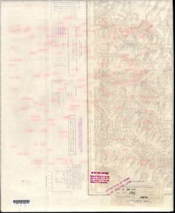
- Description:
- 1889
- Subject:
- Topical Subject: Maps, Topical Subject: Soviet Union, Geographic Subject: Republic of Crimea, and Geographic Subject: Simferopol
- Publisher:
- Генеральный штаб Красной Армии
- Language:
- Russian
- Date Created:
- 1941
- Identifier:
- VAC9619-001964
- Genre:
- Military Maps and Topographic Maps
- Geographic Location:
- Coordinates: 44.6667, 34, 45, 34.5
- Related URL:
- Catalog URL: https://iucat.iu.edu/catalog/5020129 and Download GeoTIFF: https://drive.google.com/file/d/1amvhrChXpoTfj7psOh9J6iw00E8WWa7q/view?usp=sharing
- Abstract:
- Modern area represented: Simferopol, Republic of Crimea, Ukraine
- Call Number:
- G7000 s100 .S7 sheet L-36-117
- Caption:
- Для служебного пользования
- City:
- Симферополь (Simferopol)
- Copyright Holder:
- No Copyright - United States
- Country:
- СССР (USSR)
- State/Province:
- Крымская АССР (Crimean Autonomous Soviet Socialist Republic) and РСФСР (RSFSR)
- Physical Description:
- Scale: 1:100,000
- Persistent URL:
- http://purl.dlib.indiana.edu/iudl/images/VAC9619/VAC9619-001964
- Provenance:
- DMA Topographic Center, Army Map Service Library
-
- Description:
- 1939
- Subject:
- Topical Subject: Soviet Union and Topical Subject: Maps
- Publisher:
- Наркомрыбпром Главрыбвод
- Language:
- Russian
- Date Created:
- 1940
- Identifier:
- VAC9619-002252
- Genre:
- Military Maps and Topographic Maps
- Geographic Location:
- Coordinates: 46.6667, 48, 47, 48.5
- Related URL:
- Catalog URL: https://iucat.iu.edu/catalog/5020129 and Download GeoTIFF: https://drive.google.com/file/d/1JEcZSvpfcZHSYq47tULdaaommNe3T6fT/view?usp=sharing
- Abstract:
- Modern area represented:
- Call Number:
- G7000 s100 .S7 sheet L-39-37
- Caption:
- Рабочий оттиск. Бесплатно. Временное издание. Для внутреннего использования.
- City:
- Новая Урусовка (Novaya Urusovka)
- Copyright Holder:
- No Copyright - United States
- Country:
- СССР (USSR)
- State/Province:
- РСФСР (RSFSR) and Сталинградская область (Stalingrad oblast)
- Physical Description:
- Scale: 1:100,000
- Persistent URL:
- http://purl.dlib.indiana.edu/iudl/images/VAC9619/VAC9619-002252
- Provenance:
- DMA Topographic Center, Army Map Service Library
-
- Description:
- 1928
- Subject:
- Topical Subject: Soviet Union, Topical Subject: Maps, and Geographic Subject: Voytove
- Publisher:
- Управление военных топографов
- Language:
- Russian
- Identifier:
- VAC9619-000967
- Genre:
- Military Maps and Topographic Maps
- Geographic Location:
- Coordinates: 50.333333, 31.5, 50.5, 31.75
- Related URL:
- Catalog URL: http://iucat.iu.edu/catalog/5020131 and Download GeoTIFF: https://drive.google.com/open?id=1zYnHxq-QBAq5aMuQWzs3lgGVfa8cI5rD
- Abstract:
- Modern area represented: Voytove, Kyiv oblast, Ukraine
- Call Number:
- G7000 s50 .S68 sheet M-36-52-C
- Caption:
- Не подлежит оглашению,Captured map
- City:
- Войково (Voykovo)
- Copyright Holder:
- No Copyright - United States
- Country:
- СССР (USSR)
- State/Province:
- Украинская ССР (Ukrainian Soviet Socialist Republic)
- Physical Description:
- Scale: 1:50,000
- Persistent URL:
- http://purl.dlib.indiana.edu/iudl/images/VAC9619/VAC9619-000967
- Provenance:
- DMA Topographic Center, Army Map Service Library
-
- Description:
- 1941
- Subject:
- Topical Subject: Soviet Union, Geographic Subject: Teykovo, and Topical Subject: Maps
- Publisher:
- Генеральный штаб Красной Армии
- Language:
- Russian
- Date Created:
- 1941
- Identifier:
- VAC9619-002267
- Genre:
- Topographic Maps and Military Maps
- Geographic Location:
- Coordinates: 56.6667, 40.5, 57, 41
- Related URL:
- Download GeoTIFF: https://drive.google.com/file/d/1RjM2rC6M3gF57M03QhrF9yCakUvILk10/view?usp=sharing and Catalog URL: https://iucat.iu.edu/catalog/5020129
- Abstract:
- Modern area represented: Teykovo, Ivanovo oblast, Russia
- Call Number:
- G7000 s100 .S7 sheet O-37-118
- Caption:
- Для служебного пользования
- City:
- Тейково (Teykovo)
- Copyright Holder:
- No Copyright - United States
- Country:
- СССР (USSR)
- State/Province:
- Ивановская область (Ivanovo oblast) and РСФСР (RSFSR)
- Physical Description:
- Scale: 1:100,000
- Persistent URL:
- http://purl.dlib.indiana.edu/iudl/images/VAC9619/VAC9619-002267
- Provenance:
- DMA Topographic Center, Army Map Service Library
-
- Description:
- 1936
- Subject:
- Topical Subject: Soviet Union, Topical Subject: Maps, and Geographic Subject: Šakiai
- Publisher:
- Генеральный штаб Красной Армии
- Language:
- Russian
- Date Created:
- 1940
- Identifier:
- VAC9619-003916
- Genre:
- Topographic Maps and Military Maps
- Geographic Location:
- Coordinates: 54.667, 23, 55, 23.5
- Related URL:
- Download GeoTIFF: https://drive.google.com/file/d/1yl9c3i15DB1nP-G_qji-ZbnOs8IYDGc7/view?usp=sharing and Catalog URL: https://iucat.iu.edu/catalog/5020129
- Abstract:
- Modern area represented: Šakiai, Marijampolė county, Lithuania
- Call Number:
- G7000 s100 .S7 sheet N-34-47
- Caption:
- Не подлежит оглашению
- City:
- Шаки (Shaki)
- Copyright Holder:
- No Copyright - United States
- Country:
- СССР (USSR)
- State/Province:
- Литовская ССР (Lithuanian Soviet Socialist Republic)
- Physical Description:
- Scale: 1:100,000
- Persistent URL:
- http://purl.dlib.indiana.edu/iudl/images/VAC9619/VAC9619-003916
- Provenance:
- DMA Topographic Center, Army Map Service Library
-
- Description:
- 1890
- Subject:
- Topical Subject: Soviet Union, Geographic Subject: Khmelnytskyi, and Topical Subject: Maps
- Publisher:
- Генеральный штаб РККА
- Language:
- Russian
- Date Created:
- 1940
- Identifier:
- VAC9619-003233
- Genre:
- Military Maps and Topographic Maps
- Geographic Location:
- Coordinates: 49.333, 26.5, 49.667, 27
- Related URL:
- Download GeoTIFF: https://drive.google.com/file/d/1eZqI0jbXLXLHml2ES6k_KCezVSwTmU4l/view?usp=sharing and Catalog URL: https://iucat.iu.edu/catalog/5020129
- Abstract:
- Modern area represented: Khmelnytskyi, Khmelnytskyi oblast, Ukraine
- Call Number:
- G7000 s100 .S7 sheet M-35-90
- Caption:
- Не подлежит оглашению
- City:
- Проскуров (Proskurov)
- Copyright Holder:
- No Copyright - United States
- Country:
- СССР (USSR)
- State/Province:
- Каменец-Подольская область (Kamianets-Podilskyi oblast) and Украинская ССР (Ukrainian Soviet Socialist Republic)
- Physical Description:
- Scale: 1:100,000
- Persistent URL:
- http://purl.dlib.indiana.edu/iudl/images/VAC9619/VAC9619-003233
- Provenance:
- DMA Topographic Center, Army Map Service Library
-

- Description:
- 1916
- Subject:
- Topical Subject: Maps, Topical Subject: Soviet Union, and Geographic Subject: Kublichi
- Publisher:
- Генеральный штаб РККА
- Language:
- Russian
- Date Created:
- 1936
- Identifier:
- VAC9619-004036
- Genre:
- Topographic Maps and Military Maps
- Geographic Location:
- Coordinates: 55, 28, 55.333, 28.5
- Related URL:
- Download GeoTIFF: https://drive.google.com/file/d/1qwv3V7xq3-ylgCjFe9t0yig5IBNmZ15V/view?usp=sharing and Catalog URL: https://iucat.iu.edu/catalog/5020129
- Abstract:
- Modern area represented: Kublichi, Vitebsk oblast, Belarus
- Call Number:
- G7000 s100 .S7 sheet N-35-33
- Caption:
- Не подлежит оглашению
- City:
- Кубличи (Kublichi)
- Copyright Holder:
- No Copyright - United States
- Country:
- Польша (Poland) and СССР (USSR)
- State/Province:
- Витебская область (Vitebsk oblast) and Белорусская ССР (Byelorussian Soviet Socialist Republic)
- Physical Description:
- Scale: 1:100,000
- Persistent URL:
- http://purl.dlib.indiana.edu/iudl/images/VAC9619/VAC9619-004036
- Provenance:
- DMA Topographic Center, Army Map Service Library
-
- Description:
- 1886
- Subject:
- Topical Subject: Soviet Union, Geographic Subject: Slashchevskaya, and Topical Subject: Maps
- Publisher:
- Генеральный штаб Красной Армии
- Language:
- Russian
- Date Created:
- 1941
- Identifier:
- VAC9619-003410
- Genre:
- Topographic Maps and Military Maps
- Geographic Location:
- Coordinates: 49.667, 42, 50, 42.5
- Related URL:
- Download GeoTIFF: https://drive.google.com/file/d/1MtCqnUt9UAghcR0eExtQ1pfzlaSMZb-g/view?usp=sharing and Catalog URL: https://iucat.iu.edu/catalog/5020129
- Abstract:
- Modern area represented: Slashchevskaya, Volgograd oblast, Russia
- Call Number:
- G7000 s100 .S7 sheet M-38-73
- Caption:
- Для служебного пользования
- City:
- Слащевская (Slashchevskaya)
- Copyright Holder:
- No Copyright - United States
- Country:
- СССР (USSR)
- State/Province:
- Ростовская область (Rostov oblast), Сталинградская область (Stalingrad oblast), and РСФСР (RSFSR)
- Physical Description:
- Scale: 1:100,000
- Persistent URL:
- http://purl.dlib.indiana.edu/iudl/images/VAC9619/VAC9619-003410
- Provenance:
- DMA Topographic Center, Army Map Service Library
-
- Description:
- 1896
- Subject:
- Geographic Subject: Ashmyany, Topical Subject: Soviet Union, and Topical Subject: Maps
- Publisher:
- Генеральный штаб Красной Армии
- Language:
- Russian
- Date Created:
- 1940
- Identifier:
- VAC9619-004054
- Genre:
- Military Maps and Topographic Maps
- Geographic Location:
- Coordinates: 54.333, 25.5, 54.667, 26
- Related URL:
- Catalog URL: https://iucat.iu.edu/catalog/5020129 and Download GeoTIFF: https://drive.google.com/file/d/1VKQrpZUJwdq1ZfSwfhpiT5_kAXvkbyQM/view?usp=sharing
- Abstract:
- Modern area represented: Ashmyany, Hrodna oblast, Belarus
- Call Number:
- G7000 s100 .S7 sheet N-35-52
- City:
- Ошмяны (Ashmyany)
- Copyright Holder:
- No Copyright - United States
- Country:
- СССР (USSR)
- State/Province:
- Литовская ССР (Lithuanian Soviet Socialist Republic) and Белорусская ССР (Byelorussian Soviet Socialist Republic)
- Physical Description:
- Scale: 1:100,000
- Persistent URL:
- http://purl.dlib.indiana.edu/iudl/images/VAC9619/VAC9619-004054
- Provenance:
- DMA Topographic Center, Army Map Service Library
-
- Description:
- 1934
- Subject:
- Topical Subject: Maps, Geographic Subject: Kholopenichi, and Topical Subject: Soviet Union
- Publisher:
- Генеральный штаб РККА
- Language:
- Russian
- Date Created:
- 1936
- Identifier:
- VAC9619-004060
- Genre:
- Topographic Maps and Military Maps
- Geographic Location:
- Coordinates: 54.333, 28.5, 54.667, 29
- Related URL:
- Download GeoTIFF: https://drive.google.com/file/d/1onjuqrKcfu2cD0BzmRZ9pHaNVRSwX1oU/view?usp=sharing and Catalog URL: https://iucat.iu.edu/catalog/5020129
- Abstract:
- Modern area represented: Kholopenichi, Belarus
- Call Number:
- G7000 s100 .S7 sheet N-35-58
- Caption:
- Не подлежит оглашению
- City:
- Холопеничи (Kholopenichi)
- Copyright Holder:
- No Copyright - United States
- Country:
- СССР (USSR)
- State/Province:
- Белорусская ССР (Byelorussian Soviet Socialist Republic)
- Physical Description:
- Scale: 1:100,000
- Persistent URL:
- http://purl.dlib.indiana.edu/iudl/images/VAC9619/VAC9619-004060
- Provenance:
- DMA Topographic Center, Army Map Service Library
-
- Subject:
- Geographic Subject: Kastsyukovichy, Topical Subject: Soviet Union, and Topical Subject: Maps
- Publisher:
- Генеральный штаб Красной Армии
- Language:
- Russian
- Date Created:
- 1941
- Identifier:
- VAC9619-001936
- Genre:
- Military Maps and Topographic Maps
- Geographic Location:
- Coordinates: 53.3333, 32, 53.6667, 32.5
- Related URL:
- Catalog URL: https://iucat.iu.edu/catalog/5020129 and Download GeoTIFF: https://drive.google.com/open?id=17diw8XEAG5Pvf2BuHqhMeKVNoc3ttEnL
- Abstract:
- Modern area represented: Касцюковічы (Kastsyukovichy), Mogilev district, Belarus
- Call Number:
- G7000 s100 .S7 sheet N-36-89
- City:
- Костюковичи (Kostyukovichi)
- Copyright Holder:
- No Copyright - United States
- Country:
- СССР (USSR)
- State/Province:
- РСФСР (RSFSR), Могилевская область (Mogilev oblast), Смоленская область (Smolensk oblast), and Белорусская ССР (Byelorussian Soviet Socialist Republic)
- Physical Description:
- Scale: 1:100,000
- Persistent URL:
- http://purl.dlib.indiana.edu/iudl/images/VAC9619/VAC9619-001936
- Provenance:
- DMA Topographic Center, Army Map Service Library
-
- Description:
- 1941
- Subject:
- Geographic Subject: Leninsk, Topical Subject: Maps, and Topical Subject: Soviet Union
- Publisher:
- Генеральный штаб Красной Армии
- Language:
- Russian
- Identifier:
- VAC9619-003431
- Genre:
- Military Maps and Topographic Maps
- Geographic Location:
- Coordinates: 48.667, 45, 49, 45.5
- Related URL:
- Download GeoTIFF: https://drive.google.com/file/d/14EYfkdULRIlxvozjlAms3exjHySNtHr5/view?usp=sharing and Catalog URL: https://iucat.iu.edu/catalog/5020129
- Abstract:
- Modern area represented: Leninsk, Volgograd oblast, Russia
- Call Number:
- G7000 s100 .S7 sheet M-38-115
- Caption:
- Для служебного пользования
- City:
- Ленинск (Leninsk)
- Copyright Holder:
- No Copyright - United States
- Country:
- СССР (USSR)
- State/Province:
- РСФСР (RSFSR) and Сталинградская область (Stalingrad oblast)
- Physical Description:
- Scale: 1:100,000
- Persistent URL:
- http://purl.dlib.indiana.edu/iudl/images/VAC9619/VAC9619-003431
- Provenance:
- DMA Topographic Center, Army Map Service Library
-
- Description:
- 1925
- Subject:
- Topical Subject: Maps and Topical Subject: Soviet Union
- Publisher:
- Генеральный штаб РККА
- Language:
- Russian
- Date Created:
- 1932
- Identifier:
- VAC9619-003948
- Genre:
- Topographic Maps and Military Maps
- Geographic Location:
- Coordinates: 53.667, 22, 54, 22.5
- Related URL:
- Catalog URL: https://iucat.iu.edu/catalog/5020129 and Download GeoTIFF: https://drive.google.com/file/d/14ciSWOni-z2UfNW-sIdCLfEd5I6uNINs/view?usp=sharing
- Abstract:
- Modern area represented: Poland
- Call Number:
- G7000 s100 .S7 sheet N-34-81
- City:
- Ликк (Likk)
- Copyright Holder:
- No Copyright - United States
- Country:
- СССР (USSR) and Германия (Germany)
- State/Province:
- Белорусская ССР (Byelorussian Soviet Socialist Republic)
- Physical Description:
- Scale: 1:100,000
- Persistent URL:
- http://purl.dlib.indiana.edu/iudl/images/VAC9619/VAC9619-003948
- Provenance:
- DMA Topographic Center, Army Map Service Library
-
- Description:
- 1929
- Subject:
- Topical Subject: Maps, Geographic Subject: Bakhmach, and Topical Subject: Soviet Union
- Publisher:
- Генеральный штаб Красной Армии
- Language:
- Russian
- Date Created:
- 1941
- Identifier:
- VAC9619-003274
- Genre:
- Topographic Maps and Military Maps
- Geographic Location:
- Coordinates: 51, 32.5, 51.333, 33
- Related URL:
- Download GeoTIFF: https://drive.google.com/file/d/1umoYAQWJnajCte-zrkNIKjSDraw3Xa0p/view?usp=sharing and Catalog URL: https://iucat.iu.edu/catalog/5020129
- Abstract:
- Modern area represented: Bakhmach, Chernihiv oblast, Ukraine
- Call Number:
- G7000 s100 .S7 sheet M-36-30
- City:
- Бахмач (Bakhmach)
- Copyright Holder:
- No Copyright - United States
- Country:
- СССР (USSR)
- State/Province:
- Украинская ССР (Ukrainian Soviet Socialist Republic) and Черниговская область (Chernihiv oblast)
- Physical Description:
- Scale: 1:100,000
- Persistent URL:
- http://purl.dlib.indiana.edu/iudl/images/VAC9619/VAC9619-003274
- Provenance:
- DMA Topographic Center, Army Map Service Library
-
- Description:
- 1928
- Subject:
- Topical Subject: Maps, Topical Subject: Soviet Union, and Geographic Subject: Ichnya
- Publisher:
- Генеральный штаб Красной Армии
- Language:
- Russian
- Date Created:
- 1941
- Identifier:
- VAC9619-003283
- Genre:
- Topographic Maps and Military Maps
- Geographic Location:
- Coordinates: 50.667, 32, 51, 32.5
- Related URL:
- Catalog URL: https://iucat.iu.edu/catalog/5020129 and Download GeoTIFF: https://drive.google.com/file/d/1Ac29ODFpGjgWmzV6weqS5xHNFSvVVWYm/view?usp=sharing
- Abstract:
- Modern area represented: Ichnya, Chernihiv oblast, Ukraine
- Call Number:
- G7000 s100 .S7 sheet M-36-41
- City:
- Ичня (Ichnya)
- Copyright Holder:
- No Copyright - United States
- Country:
- СССР (USSR)
- State/Province:
- Украинская ССР (Ukrainian Soviet Socialist Republic) and Черниговская область (Chernihiv oblast)
- Physical Description:
- Scale: 1:100,000
- Persistent URL:
- http://purl.dlib.indiana.edu/iudl/images/VAC9619/VAC9619-003283
- Provenance:
- DMA Topographic Center, Army Map Service Library
-
- Description:
- 1940
- Subject:
- Topical Subject: Maps, Topical Subject: Soviet Union, and Geographic Subject: Konstantinovo
- Publisher:
- Генеральный штаб Красной Армии
- Language:
- Russian
- Date Created:
- 1941
- Identifier:
- VAC9619-002270
- Genre:
- Topographic Maps and Military Maps
- Geographic Location:
- Coordinates: 56.3333, 38, 56.6667, 38.5
- Related URL:
- Catalog URL: https://iucat.iu.edu/catalog/5020129 and Download GeoTIFF: https://drive.google.com/file/d/18TKm-zzpCkazemDPv8SYfhfO8Ynm9ivL/view?usp=sharing
- Abstract:
- Modern area represented: Konstantinovo, Russia
- Call Number:
- G7000 s100 .S7 sheet O-37-125
- Caption:
- Для служебного пользования
- City:
- Константиново (Konstantinovo)
- Copyright Holder:
- No Copyright - United States
- Country:
- СССР (USSR)
- State/Province:
- Ивановская область (Ivanovo oblast), Московская область (Moscow oblast), and Ярославская область (Yaroslavl oblast)
- Physical Description:
- Scale: 1:100,000
- Persistent URL:
- http://purl.dlib.indiana.edu/iudl/images/VAC9619/VAC9619-002270
- Provenance:
- DMA Topographic Center, Army Map Service Library
-
- Description:
- 1936
- Subject:
- Topical Subject: Maps, Topical Subject: Soviet Union, and Geographic Subject: Shumilina
- Publisher:
- Генеральный штаб РККА
- Language:
- Russian
- Identifier:
- VAC9619-004038
- Genre:
- Topographic Maps and Military Maps
- Geographic Location:
- Coordinates: 55, 29.5, 55.333, 30
- Related URL:
- Download GeoTIFF: https://drive.google.com/file/d/1nvlhkY4re7Tb2KQEDToP7LoExskmZqai/view?usp=sharing and Catalog URL: https://iucat.iu.edu/catalog/5020129
- Abstract:
- Modern area represented: Shumilina, Vitebsk oblast, Belarus
- Call Number:
- G7000 s100 .S7 sheet N-35-36
- Caption:
- Не подлежит оглашению
- City:
- Шумилино (Shumilina)
- Copyright Holder:
- No Copyright - United States
- Country:
- СССР (USSR)
- State/Province:
- Белорусская ССР (Byelorussian Soviet Socialist Republic) and Витебская область (Vitebsk oblast)
- Physical Description:
- Scale: 1:100,000
- Persistent URL:
- http://purl.dlib.indiana.edu/iudl/images/VAC9619/VAC9619-004038
- Provenance:
- DMA Topographic Center, Army Map Service Library
-
- Description:
- 1903
- Subject:
- Topical Subject: Maps, Topical Subject: Soviet Union, and Geographic Subject: Pastavy
- Publisher:
- Генеральный штаб Красной Армии
- Language:
- Russian
- Date Created:
- 1936
- Identifier:
- VAC9619-004033
- Genre:
- Topographic Maps and Military Maps
- Geographic Location:
- Coordinates: 55, 26.5, 55.333, 27
- Related URL:
- Download GeoTIFF: https://drive.google.com/file/d/1Ynk6JxAB7yA5oy7GB_jG4JWPQqhw5OhT/view?usp=sharing and Catalog URL: https://iucat.iu.edu/catalog/5020129
- Abstract:
- Modern area represented: Pastavy, Vileyka oblast, Belarus
- Call Number:
- G7000 s100 .S7 sheet N-35-30
- City:
- Поставы (Pastavy)
- Copyright Holder:
- No Copyright - United States
- Country:
- СССР (USSR)
- State/Province:
- Вилейская область (Vileyka oblast) and Белорусская ССР (Byelorussian Soviet Socialist Republic)
- Physical Description:
- Scale: 1:100,000
- Persistent URL:
- http://purl.dlib.indiana.edu/iudl/images/VAC9619/VAC9619-004033
- Provenance:
- DMA Topographic Center, Army Map Service Library
-
- Description:
- 1929
- Subject:
- Geographic Subject: Троїцьке (Troyitske), Topical Subject: Soviet Union, and Topical Subject: Maps
- Publisher:
- Управление военных топографов
- Language:
- Russian
- Identifier:
- VAC9619-000120
- Genre:
- Topographic Maps and Military Maps
- Geographic Location:
- Coordinates: 46.5, 30, 46.6667, 30.25
- Related URL:
- Catalog URL: http://iucat.iu.edu/catalog/5020131, Download GeoTIFF: https://drive.google.com/open?id=1UDMuWV6KgCLjaqKbjycJK5oUTerwh9NA, and https://drive.goo...
- Abstract:
- Modern area represented: Troyitske, Odessa oblast, Ukraine
- Call Number:
- G7000 s50 .S68 sheet L-36-49-A
- Caption:
- Не подлежит оглашению,Секретно
- City:
- Троицкое (Troitskoye)
- Copyright Holder:
- No Copyright - United States
- Country:
- СССР (USSR)
- State/Province:
- Одесская область (Odessa oblast) and Украинская ССР (Ukrainian Soviet Socialist Republic)
- Physical Description:
- Scale: 1:50,000
- Persistent URL:
- http://purl.dlib.indiana.edu/iudl/images/VAC9619/VAC9619-000120
- Provenance:
- DMA Topographic Center, Army Map Service Library
-
- Description:
- 1926
- Subject:
- Topical Subject: Maps, Topical Subject: Soviet Union, and Geographic Subject: Podgornoye
- Publisher:
- Генеральный штаб Красной Армии
- Language:
- Russian
- Date Created:
- 1942
- Identifier:
- VAC9619-002051
- Genre:
- Military Maps and Topographic Maps
- Geographic Location:
- Coordinates: 46.3333, 43, 46.6667, 43.5
- Related URL:
- Catalog URL: https://iucat.iu.edu/catalog/5020129 and Download GeoTIFF: https://drive.google.com/open?id=1lARi5KaR_Y9aViQ8vZqLsGYlEG_w9acy
- Abstract:
- Modern area represented: Podgornoye, Rostov oblast, Russia
- Call Number:
- G7000 s100 .S7 sheet L-38-51
- Caption:
- Для служебного пользования
- City:
- Подгорный (Podgorniy)
- Copyright Holder:
- No Copyright - United States
- Country:
- СССР (USSR)
- State/Province:
- Калмыцкая АССР (Kalmyk Autonomous Soviet Socialist Republic), РСФСР (RSFSR), and Ростовская область (Rostov oblast)
- Physical Description:
- Scale: 1:100,000
- Persistent URL:
- http://purl.dlib.indiana.edu/iudl/images/VAC9619/VAC9619-002051
- Provenance:
- DMA Topographic Center, Army Map Service Library
-
- Description:
- 1934
- Subject:
- Topical Subject: Soviet Union, Geographic Subject: Bolshoy Sundyr, and Topical Subject: Maps
- Language:
- Russian
- Identifier:
- VAC9619-002279
- Genre:
- Topographic Maps and Military Maps
- Geographic Location:
- Coordinates: 56, 46.5, 56.3333, 47
- Related URL:
- Catalog URL: https://iucat.iu.edu/catalog/5020129 and Download GeoTIFF: https://drive.google.com/file/d/1cbWuZe6lGUjLhtzCUAjYuKuexOLcD5uK/view?usp=sharing
- Abstract:
- Modern area represented: Bolshoy Sundyr, Russia
- Call Number:
- G7000 s100 .S7 sheet O-38-142
- City:
- Б. Сундырь (Bolshoy Sundyr)
- Copyright Holder:
- No Copyright - United States
- Country:
- СССР (USSR)
- State/Province:
- Ишлейский район (Ishlei district), Татар-Касинский район (Tatar-Kasinsky district), and Чувашская АССР (Chuvash Autonomous Soviet Socialist Republic)
- Physical Description:
- Scale: 1:100,000
- Persistent URL:
- http://purl.dlib.indiana.edu/iudl/images/VAC9619/VAC9619-002279
- Provenance:
- DMA Topographic Center, Army Map Service Library
-
- Subject:
- Topical Subject: Soviet Union, Topical Subject: Maps, and Geographic Subject: Dugna
- Publisher:
- Генеральный штаб Красной Армии
- Language:
- Russian
- Date Created:
- 1941
- Identifier:
- VAC9619-003108
- Genre:
- Military Maps and Topographic Maps
- Geographic Location:
- Coordinates: 54.333, 36.5, 54.667, 37
- Related URL:
- Download GeoTIFF: https://drive.google.com/file/d/1No0hIFDmOmh2uBKf7eH3i2AMx6bCxIRq/view?usp=sharing and Catalog URL: https://iucat.iu.edu/catalog/5020129
- Abstract:
- Modern area represented: Дугна (Dugna), Kaluzhskaya oblast, Russia
- Call Number:
- G7000 s100 .S7 sheet N-37-50
- Caption:
- Captured map
- City:
- Дугна (Dugna)
- Copyright Holder:
- No Copyright - United States
- Country:
- СССР (USSR)
- State/Province:
- РСФСР (RSFSR) and Тульская область (Tula oblast)
- Physical Description:
- Scale: 1:100,000
- Persistent URL:
- http://purl.dlib.indiana.edu/iudl/images/VAC9619/VAC9619-003108
- Provenance:
- DMA Topographic Center, Army Map Service Library
-
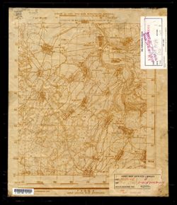
- Subject:
- Topical Subject: Maps, Geographic Subject: Hrebinka, and Topical Subject: Soviet Union
- Publisher:
- Генеральный штаб Красной Армии
- Language:
- Russian
- Identifier:
- VAC9619-003294
- Genre:
- Military Maps and Topographic Maps
- Geographic Location:
- Coordinates: 50, 32, 50.5, 32.5
- Related URL:
- Catalog URL: https://iucat.iu.edu/catalog/5020129 and Download GeoTIFF: https://drive.google.com/file/d/1o_CCKouW8G2bUf6ptlUF8Am6lslsladg/view?usp=sharing
- Abstract:
- Modern area represented: Hrebinka, Poltava oblast, Ukraine
- Call Number:
- G7000 s100 .S7 sheet M-36-65
- City:
- Гребенка (Hrebinka)
- Copyright Holder:
- No Copyright - United States
- Country:
- СССР (USSR)
- State/Province:
- Полтавская область (Poltava oblast) and Украинская ССР (Ukrainian Soviet Socialist Republic)
- Physical Description:
- Scale: 1:100,000
- Persistent URL:
- http://purl.dlib.indiana.edu/iudl/images/VAC9619/VAC9619-003294
- Provenance:
- DMA Topographic Center, Army Map Service Library
-
- Subject:
- Topical Subject: Soviet Union, Topical Subject: Maps, and Geographic Subject: Spas-Klepiki
- Language:
- Russian
- Identifier:
- VAC9619-003097
- Genre:
- Military Maps and Topographic Maps
- Geographic Location:
- Coordinates: 55, 40, 55.333, 40.5
- Related URL:
- Download GeoTIFF: https://drive.google.com/file/d/1inftQP519VcOqiW-ANGp8iQ2bx8rWMGP/view?usp=sharing and Catalog URL: https://iucat.iu.edu/catalog/5020129
- Abstract:
- Modern area represented: Спас-Клепики (Spas-Klepiki), Ryazanskaya oblast, Russia
- Call Number:
- G7000 s100 .S7 sheet N-37-33
- City:
- Спас-Клепики (Spas-Klepiki)
- Copyright Holder:
- No Copyright - United States
- Country:
- СССР (USSR)
- Physical Description:
- Scale: 1:100,000
- Persistent URL:
- http://purl.dlib.indiana.edu/iudl/images/VAC9619/VAC9619-003097
- Provenance:
- DMA Topographic Center, Army Map Service Library
-
- Description:
- 1926
- Subject:
- Geographic Subject: Zhuravlyovka, Topical Subject: Soviet Union, and Topical Subject: Maps
- Publisher:
- Генеральный штаб Красной Армии
- Language:
- Russian
- Date Created:
- 1941
- Identifier:
- VAC9619-002299
- Genre:
- Military Maps and Topographic Maps
- Geographic Location:
- Coordinates: 46.6667, 41, 47, 41.5
- Related URL:
- Catalog URL: https://iucat.iu.edu/catalog/5020129 and Download GeoTIFF: https://drive.google.com/file/d/1RZe7TX8nGnwp5iv7M1fYWr1GLhQJkoo7/view?usp=sharing
- Abstract:
- Modern area represented: Zhuravlyovka, Russia
- Call Number:
- G7000 s100 .S7 sheet L-37-47
- Caption:
- Для служебного пользования
- City:
- Журавлевка (Zhuravlyovka)
- Copyright Holder:
- No Copyright - United States
- Country:
- СССР (USSR)
- State/Province:
- Ростовская область (Rostov oblast) and РСФСР (RSFSR)
- Physical Description:
- Scale: 1:100,000
- Persistent URL:
- http://purl.dlib.indiana.edu/iudl/images/VAC9619/VAC9619-002299
- Provenance:
- DMA Topographic Center, Army Map Service Library
-
- Description:
- 1939
- Subject:
- Topical Subject: Maps, Geographic Subject: Atyraū, Topical Subject: Soviet Union, and Geographic Subject: Surkhan
- Publisher:
- Наркомрыбпром Главрыбвод
- Language:
- Russian
- Identifier:
- VAC9619-002255
- Genre:
- Topographic Maps and Military Maps
- Geographic Location:
- Coordinates: 46.3333, 49.5, 46.6667, 50
- Related URL:
- Download GeoTIFF: https://drive.google.com/file/d/17dQsDfhKepOgCTMRu9XS9x3X0Ssg7hAK/view?usp=sharing and Catalog URL: https://iucat.iu.edu/catalog/5020129
- Abstract:
- Modern area represented: Сурхан (Surkhan), Atyraū, Kazakhstan
- Call Number:
- G7000 s100 .S7 sheet L-39-52
- Caption:
- Для внутреннего использования. Рабочий оттиск. Бесплатно.
- City:
- Сурхан (Surkhan)
- Copyright Holder:
- No Copyright - United States
- Country:
- СССР (USSR)
- State/Province:
- Казахская ССР (Kazakh Soviet Socialist Republic) and Гуриевская область (Guriev oblast)
- Physical Description:
- Scale: 1:100,000
- Persistent URL:
- http://purl.dlib.indiana.edu/iudl/images/VAC9619/VAC9619-002255
- Provenance:
- DMA Topographic Center, Army Map Service Library
-
- Description:
- 1931
- Subject:
- Geographic Subject: Beketovka, Topical Subject: Maps, and Topical Subject: Soviet Union
- Publisher:
- Генеральный штаб Красной Армии
- Language:
- Russian
- Date Created:
- 1941
- Identifier:
- VAC9619-003436
- Genre:
- Topographic Maps and Military Maps
- Geographic Location:
- Coordinates: 48.333, 44, 48.667, 44.5
- Related URL:
- Catalog URL: https://iucat.iu.edu/catalog/5020129 and Download GeoTIFF: https://drive.google.com/file/d/1sJjvWyUwEDoxK1R9KYj8UGSqzpKxj-EO/view?usp=sharing
- Abstract:
- Modern area represented: Beketovka, Volgograd oblast, Russia
- Call Number:
- G7000 s100 .S7 sheet M-38-125
- Caption:
- Секретно
- City:
- Бекетовка (Beketovka)
- Copyright Holder:
- No Copyright - United States
- Country:
- СССР (USSR)
- State/Province:
- РСФСР (RSFSR) and Сталинградская область (Stalingrad oblast)
- Physical Description:
- Scale: 1:100,000
- Persistent URL:
- http://purl.dlib.indiana.edu/iudl/images/VAC9619/VAC9619-003436
- Provenance:
- DMA Topographic Center, Army Map Service Library
-
- Description:
- 1940
- Subject:
- Geographic Subject: Vyselki, Topical Subject: Soviet Union, and Topical Subject: Maps
- Publisher:
- Генеральный штаб Красной Армии
- Language:
- Russian
- Date Created:
- 1941
- Identifier:
- VAC9619-002351
- Genre:
- Topographic Maps and Military Maps
- Geographic Location:
- Coordinates: 45.333, 39.5, 45.667, 40
- Related URL:
- Catalog URL: https://iucat.iu.edu/catalog/5020129 and Download GeoTIFF: https://drive.google.com/file/d/1RbJVTEmf-PM-QQ0AjcaM7Rm_PcbhTWc5/view?usp=sharing
- Abstract:
- Modern area represented: Vyselki, Russia
- Call Number:
- G7000 s100 .S7 sheet L-37-92
- Caption:
- Для служебного пользования
- City:
- Выселки (Vyselki)
- Copyright Holder:
- No Copyright - United States
- Country:
- СССР (USSR)
- State/Province:
- Краснодарский край (Krasnodar kray) and РСФСР (RSFSR)
- Physical Description:
- Scale: 1:100,000
- Persistent URL:
- http://purl.dlib.indiana.edu/iudl/images/VAC9619/VAC9619-002351
- Provenance:
- DMA Topographic Center, Army Map Service Library
-
- Description:
- 1939
- Subject:
- Geographic Subject: Kalach-Kurtlak, Topical Subject: Maps, and Topical Subject: Soviet Union
- Publisher:
- Генеральный штаб Красной Армии
- Language:
- Russian
- Date Created:
- 1941
- Identifier:
- VAC9619-003425
- Genre:
- Topographic Maps and Military Maps
- Geographic Location:
- Coordinates: 48.667, 42, 49, 42.5
- Related URL:
- Catalog URL: https://iucat.iu.edu/catalog/5020129 and Download GeoTIFF: https://drive.google.com/file/d/1LhwC-Jpz1ffc5h6r3428J5_sXuupOlRT/view?usp=sharing
- Abstract:
- Modern area represented: Kalach-Kurtlak, Rostov oblast, Russia
- Call Number:
- G7000 s100 .S7 sheet M-38-109
- Caption:
- Для служебного пользования
- City:
- Калач-Куртлак (Kalach-Kurtlak)
- Copyright Holder:
- No Copyright - United States
- Country:
- СССР (USSR)
- State/Province:
- Ростовская область (Rostov oblast), Сталинградская область (Stalingrad oblast), and РСФСР (RSFSR)
- Physical Description:
- Scale: 1:100,000
- Persistent URL:
- http://purl.dlib.indiana.edu/iudl/images/VAC9619/VAC9619-003425
- Provenance:
- DMA Topographic Center, Army Map Service Library
-
- Description:
- 1913
- Subject:
- Geographic Subject: Borodyanka, Topical Subject: Maps, and Topical Subject: Soviet Union
- Publisher:
- Управление военных топографов
- Language:
- Russian
- Identifier:
- VAC9619-000229
- Genre:
- Military Maps and Topographic Maps
- Geographic Location:
- Coordinates: 50.5, 29.75, 50.667, 30
- Related URL:
- Download GeoTIFF: https://drive.google.com/open?id=1Uzx9pgj_zvaDQD4JKbgOHpJ1lfzZeS7y and Catalog URL: http://iucat.iu.edu/catalog/5020131
- Abstract:
- Modern area represented: Borodyanka, Kyiv oblast, Ukraine
- Call Number:
- G7000 s50 .S68 sheet M-35-60-B
- Caption:
- Не подлежит оглашению
- City:
- Бородянка (Borodyanka)
- Copyright Holder:
- No Copyright - United States
- Country:
- СССР (USSR)
- State/Province:
- Киевская область (Kyiv oblast) and Украинская ССР (Ukrainian Soviet Socialist Republic)
- Physical Description:
- Scale: 1:50,000
- Persistent URL:
- http://purl.dlib.indiana.edu/iudl/images/VAC9619/VAC9619-000229
- Provenance:
- DMA Topographic Center, Army Map Service Library
-
- Description:
- 1931
- Subject:
- Geographic Subject: Gromoslavka, Topical Subject: Maps, and Topical Subject: Soviet Union
- Publisher:
- Генеральный штаб Красной Армии
- Language:
- Russian
- Date Created:
- 1941
- Identifier:
- VAC9619-003443
- Genre:
- Topographic Maps and Military Maps
- Geographic Location:
- Coordinates: 48, 43.5, 48.333, 44
- Related URL:
- Catalog URL: https://iucat.iu.edu/catalog/5020129 and Download GeoTIFF: https://drive.google.com/file/d/1tYy5n_oK5nQpH0QLNkcEDm0KQpLC8FPN/view?usp=sharing
- Abstract:
- Modern area represented: Gromoslavka, Volgograd oblast, Russia
- Call Number:
- G7000 s100 .S7 sheet M-38-136
- Caption:
- Для служебного пользования
- City:
- Громославка (Gromoslavka)
- Copyright Holder:
- No Copyright - United States
- Country:
- СССР (USSR)
- State/Province:
- РСФСР (RSFSR) and Сталинградская область (Stalingrad oblast)
- Physical Description:
- Scale: 1:100,000
- Persistent URL:
- http://purl.dlib.indiana.edu/iudl/images/VAC9619/VAC9619-003443
- Provenance:
- DMA Topographic Center, Army Map Service Library
-
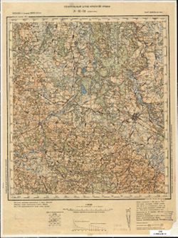
- Description:
- 1903
- Subject:
- Geographic Subject: Smarhon, Topical Subject: Maps, and Topical Subject: Soviet Union
- Publisher:
- Генеральный штаб Красной Армии
- Language:
- Russian
- Date Created:
- 1940
- Identifier:
- VAC9619-004055
- Genre:
- Topographic Maps and Military Maps
- Geographic Location:
- Coordinates: 54.333, 26, 54.667, 26.5
- Related URL:
- Download GeoTIFF: https://drive.google.com/file/d/1Hyh1FTHPh2WfcSA6rFTZ67hecvz2-9cA/view?usp=sharing and Catalog URL: https://iucat.iu.edu/catalog/5020129
- Abstract:
- Modern area represented: Smarhon, Hrodna oblast, Belarus
- Call Number:
- G7000 s100 .S7 sheet N-35-53
- City:
- Сморгонь (Smarhon)
- Copyright Holder:
- No Copyright - United States
- Country:
- СССР (USSR)
- State/Province:
- Белорусская ССР (Byelorussian Soviet Socialist Republic) and Вилейская область (Vileyka oblast)
- Physical Description:
- Scale: 1:100,000
- Persistent URL:
- http://purl.dlib.indiana.edu/iudl/images/VAC9619/VAC9619-004055
- Provenance:
- DMA Topographic Center, Army Map Service Library
-
- Description:
- 1890
- Subject:
- Geographic Subject: Druskininkai, Topical Subject: Soviet Union, and Topical Subject: Maps
- Publisher:
- Генеральный штаб Красной Армии
- Language:
- Russian
- Date Created:
- 1940
- Identifier:
- VAC9619-003940
- Genre:
- Topographic Maps and Military Maps
- Geographic Location:
- Coordinates: 54, 23.5, 54.333, 24
- Related URL:
- Catalog URL: https://iucat.iu.edu/catalog/5020129 and Download GeoTIFF: https://drive.google.com/file/d/1fVmLCB9FxdoaO03vgdau2SmN2DopTPfv/view?usp=sharing
- Abstract:
- Modern area represented: Druskininkai, Alytus, Lithuania
- Call Number:
- G7000 s100 .S7 sheet N-34-72
- Caption:
- Для служебного пользования
- City:
- Друскеники (Druskininkai)
- Copyright Holder:
- No Copyright - United States
- Country:
- СССР (USSR)
- State/Province:
- Белорусская ССР (Byelorussian Soviet Socialist Republic), Литовская ССР (Lithuanian Soviet Socialist Republic), and Область государственных интересов Германи...
- Physical Description:
- Scale: 1:100,000
- Persistent URL:
- http://purl.dlib.indiana.edu/iudl/images/VAC9619/VAC9619-003940
- Provenance:
- DMA Topographic Center, Army Map Service Library
