
Search Constraints
You searched for:
Campus
IUB
Remove constraint Campus: IUB
Country
United States
Remove constraint Country: United States
Creator
Cushman, Charles W., 1896-1972
Remove constraint Creator: Cushman, Charles W., 1896-1972
Pages
0-99 pages
Remove constraint Pages: 0-99 pages
Subject
Clouds
Remove constraint Subject: Clouds
State/Province
Colorado
Remove constraint State/Province: Colorado
« Previous |
1 - 20 of 90
|
Next »
Search Results
-
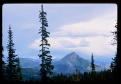
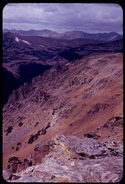
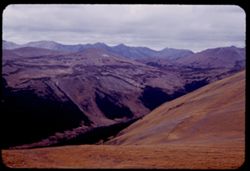
- Description:
- 100 f 11 tl
- Subject:
- Rabbit Ears Pass (Colo.), Firs, Passes (Landforms), Valleys, Forests, Mountains, and Clouds
- Series:
- 9-66
- Creator:
- Cushman, Charles W., 1896-1972
- Date Created:
- 1966-06-15
- Genre:
- Landscape photographs
- Frame Number:
- 30
- Street Address:
- United States Highway 40
- Call Number:
- P15433
- Country:
- United States
- State/Province:
- Colorado
- Alternate Identifier:
- 966.30
- Persistent URL:
- http://purl.dlib.indiana.edu/iudl/archives/cushman/P15433
- Holding Location:
- Bloomington - University Archives
Wells Library E460
1320 E 10th St.
Bloomington, IN 47405
Contact at archives@indiana.edu, 812-855-1127
-
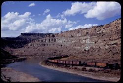
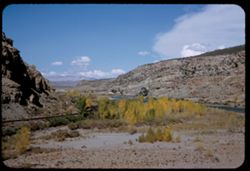
- Description:
- 50 f 11
- Subject:
- Erosion, Canyons, Valleys, Denver and Rio Grande Western Railway Company, Roads, Cliffs, Rocks, Colorado River (Colo.-Mexico), Rivers, Horseshoe Canyon (Colo...
- Series:
- 9-53
- Creator:
- Cushman, Charles W., 1896-1972
- Date Created:
- 1953-10-12
- Genre:
- Snapshots
- Frame Number:
- 32
- County:
- Mesa
- Abstract:
- Freight train in curve
- Call Number:
- P06833
- City:
- Grand Junction
- Country:
- United States
- State/Province:
- Colorado
- Alternate Identifier:
- 953.32
- Persistent URL:
- http://purl.dlib.indiana.edu/iudl/archives/cushman/P06833
- Holding Location:
- Bloomington - University Archives
Wells Library E460
1320 E 10th St.
Bloomington, IN 47405
Contact at archives@indiana.edu, 812-855-1127
-
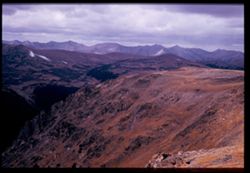
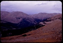
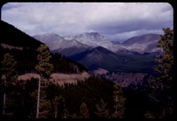
- Description:
- 50 f 8
- Subject:
- National parks & reserves, Rocky Mountains, Passes (Landforms), Rocky Mountain National Park (Colo.), Forests, Roads, Cliffs, Mountains, Rocks, and Clouds
- Series:
- 25-52
- Creator:
- Cushman, Charles W., 1896-1972
- Date Created:
- 1952-11-01
- Genre:
- Landscape photographs
- Frame Number:
- 6
- Abstract:
- View west from pass of 12,110 ft elev.
- Call Number:
- P06375
- Country:
- United States
- State/Province:
- Colorado
- Physical Description:
- Image was originally mounted in a glass enclosure. Before digitization, the image was removed and placed in a Wess Plastic, Inc. brand, 2" x 2", pl...
- Alternate Identifier:
- 2552.6
- Persistent URL:
- http://purl.dlib.indiana.edu/iudl/archives/cushman/P06375
- Holding Location:
- Bloomington - University Archives
Wells Library E460
1320 E 10th St.
Bloomington, IN 47405
Contact at archives@indiana.edu, 812-855-1127
-
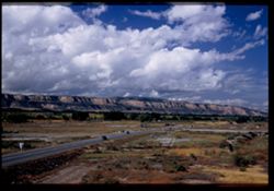
- Description:
- 50 f 6.3 Pola
- Subject:
- Grasses, Roads, Colorado National Monument (Colo.), Automobiles, Trees, Plains, Mountains, Shrubs, Traffic signs & signals, Clouds, Hills, and Mesas
- Series:
- 9-53
- Creator:
- Cushman, Charles W., 1896-1972
- Date Created:
- 1953-10-12
- Genre:
- Landscape photographs
- Frame Number:
- 23
- Street Address:
- United States Highway 50
- County:
- Mesa
- Abstract:
- View west from Grand Junction toward Colo Nat'l Mon.
- Call Number:
- P06824
- City:
- Grand Junction
- Country:
- United States
- State/Province:
- Colorado
- Physical Description:
- Image was originally mounted in a glass enclosure. Before digitization, the image was removed and placed in a Wess Plastic, Inc. brand, 2" x 2", pl...
- Alternate Identifier:
- 953.23
- Persistent URL:
- http://purl.dlib.indiana.edu/iudl/archives/cushman/P06824
- Holding Location:
- Bloomington - University Archives
Wells Library E460
1320 E 10th St.
Bloomington, IN 47405
Contact at archives@indiana.edu, 812-855-1127
-
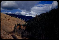
- Description:
- 50 f 8
- Subject:
- National parks & reserves, Rocky Mountains, Passes (Landforms), Rocky Mountain National Park (Colo.), Forests, Cliffs, Mountains, Shrubs, Trees, Rocks, a...
- Series:
- 25-52
- Creator:
- Cushman, Charles W., 1896-1972
- Date Created:
- 1952-11-01
- Genre:
- Landscape photographs
- Frame Number:
- 5
- Abstract:
- View west from pass of 12,110 ft elev.
- Call Number:
- P06374
- Country:
- United States
- State/Province:
- Colorado
- Alternate Identifier:
- 2552.5
- Persistent URL:
- http://purl.dlib.indiana.edu/iudl/archives/cushman/P06374
- Holding Location:
- Bloomington - University Archives
Wells Library E460
1320 E 10th St.
Bloomington, IN 47405
Contact at archives@indiana.edu, 812-855-1127
-
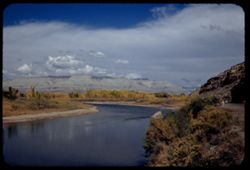
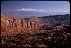
- Description:
- 50 f 11
- Subject:
- Rocks, Canyons, Grasses, Colorado River (Colo.-Mexico), Horseshoe Canyon (Colo.), Mountains, Shrubs, Clouds, Hills, and Rivers
- Series:
- 9-53
- Creator:
- Cushman, Charles W., 1896-1972
- Date Created:
- 1953-10-12
- Genre:
- Landscape photographs
- Frame Number:
- 29
- County:
- Mesa
- Abstract:
- Up and [?]on the Colorado river from top of horseshoe canyon on curve 28 miles east of Grand Junction
- Call Number:
- P06830
- City:
- Grand Junction
- Country:
- United States
- State/Province:
- Colorado
- Alternate Identifier:
- 953.29
- Persistent URL:
- http://purl.dlib.indiana.edu/iudl/archives/cushman/P06830
- Holding Location:
- Bloomington - University Archives
Wells Library E460
1320 E 10th St.
Bloomington, IN 47405
Contact at archives@indiana.edu, 812-855-1127
-
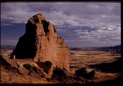
- Description:
- 25 f 6.3 pola
- Subject:
- Red Rocks Park (Jefferson County, Colo.), Parks, Roads, Cliffs, Mountains, Shrubs, Boulders, Rocks, Buttes, Rock formations, Hills, Buildings, and Clouds
- Series:
- 24-52
- Creator:
- Cushman, Charles W., 1896-1972
- Date Created:
- 1952-10-30
- Genre:
- Landscape photographs
- Frame Number:
- 2
- County:
- Jefferson
- Abstract:
- Red Rock Park west of Denver
- Call Number:
- P06333
- City:
- Morrison
- Country:
- United States
- State/Province:
- Colorado
- Physical Description:
- Image was originally mounted in a glass enclosure. Before digitization, the image was removed and placed in a Wess Plastic, Inc. brand, 2" x 2", pl...
- Alternate Identifier:
- 2452.2
- Persistent URL:
- http://purl.dlib.indiana.edu/iudl/archives/cushman/P06333
- Holding Location:
- Bloomington - University Archives
Wells Library E460
1320 E 10th St.
Bloomington, IN 47405
Contact at archives@indiana.edu, 812-855-1127
-
- Description:
- 25 f 4.5 POLA
- Subject:
- Red Rocks Amphitheatre, Rock formations, Rocks, Red Rocks Park (Jefferson County, Colo.), Hills, Mountains, Shadows, Clouds, Amphitheaters, Parks, and Boulders
- Series:
- 24-52
- Creator:
- Cushman, Charles W., 1896-1972
- Date Created:
- 1952-10-30
- Genre:
- Landscape photographs
- Frame Number:
- 11
- County:
- Jefferson and Denver
- Abstract:
- View SE and down from Red Rocks Amphitheatre
- Call Number:
- P06342
- City:
- Morrison and Denver
- Country:
- United States
- State/Province:
- Colorado
- Alternate Identifier:
- 2452.11
- Persistent URL:
- http://purl.dlib.indiana.edu/iudl/archives/cushman/P06342
- Holding Location:
- Bloomington - University Archives
Wells Library E460
1320 E 10th St.
Bloomington, IN 47405
Contact at archives@indiana.edu, 812-855-1127
-
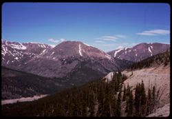
- Description:
- 50 f 5.6
- Subject:
- National parks & reserves, Rocky Mountains, Valleys, Rocky Mountain National Park (Colo.), Forests, Mountains, and Clouds
- Series:
- 25-52
- Creator:
- Cushman, Charles W., 1896-1972
- Date Created:
- 1952-11-01
- Genre:
- Landscape photographs
- Frame Number:
- 7
- Street Address:
- United States Highway
- Abstract:
- Yellow + brown.
- Call Number:
- P06376
- Country:
- United States
- State/Province:
- Colorado
- Alternate Identifier:
- 2552.7
- Persistent URL:
- http://purl.dlib.indiana.edu/iudl/archives/cushman/P06376
- Holding Location:
- Bloomington - University Archives
Wells Library E460
1320 E 10th St.
Bloomington, IN 47405
Contact at archives@indiana.edu, 812-855-1127
-
- Description:
- 25 f 4
- Subject:
- Rocks, Valleys, Roads, Trees, Mountains, Clouds, Forests, Passes (Landforms), and Loveland Pass (Colo.)
- Series:
- 25-52
- Creator:
- Cushman, Charles W., 1896-1972
- Date Created:
- 1952-11-01
- Genre:
- Landscape photographs
- Frame Number:
- 14
- Abstract:
- North from Loveland Pass.
- Call Number:
- P06383
- Country:
- United States
- State/Province:
- Colorado
- Alternate Identifier:
- 2552.14
- Persistent URL:
- http://purl.dlib.indiana.edu/iudl/archives/cushman/P06383
- Holding Location:
- Bloomington - University Archives
Wells Library E460
1320 E 10th St.
Bloomington, IN 47405
Contact at archives@indiana.edu, 812-855-1127
-
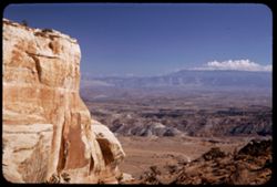
- Description:
- 50 f 8 Pola
- Subject:
- Rocks, Canyons, Grasses, Roads, Automobiles, Mesas, Colorado River (Colo.-Mexico), Mountains, Shrubs, Clouds, Hills, Rivers, and Trees
- Series:
- 9-53
- Creator:
- Cushman, Charles W., 1896-1972
- Date Created:
- 1953-10-12
- Genre:
- Landscape photographs
- Frame Number:
- 34
- County:
- Mesa
- Abstract:
- View north up river around bend
- Call Number:
- P06835
- City:
- Grand Junction
- Country:
- United States
- State/Province:
- Colorado
- Alternate Identifier:
- 953.34
- Persistent URL:
- http://purl.dlib.indiana.edu/iudl/archives/cushman/P06835
- Holding Location:
- Bloomington - University Archives
Wells Library E460
1320 E 10th St.
Bloomington, IN 47405
Contact at archives@indiana.edu, 812-855-1127
-
- Subject:
- Snow, Roads, Trees, Mountains, Clouds, Forests, Passes (Landforms), and Loveland Pass (Colo.)
- Series:
- 9-66
- Creator:
- Cushman, Charles W., 1896-1972
- Date Created:
- 1966-06-14
- Genre:
- Landscape photographs
- Frame Number:
- 17
- County:
- Larimer
- Call Number:
- P15420
- Country:
- United States
- State/Province:
- Colorado
- Alternate Identifier:
- 966.17
- Persistent URL:
- http://purl.dlib.indiana.edu/iudl/archives/cushman/P15420
- Holding Location:
- Bloomington - University Archives
Wells Library E460
1320 E 10th St.
Bloomington, IN 47405
Contact at archives@indiana.edu, 812-855-1127
-
- Description:
- 25 f 6.3 Pola
- Subject:
- Rocks, Canyons, Cliffs, Colorado National Monument (Colo.), Mesas, Boulders, Mountains, Shrubs, Clouds, Valleys, and National parks & reserves
- Series:
- 26-52
- Creator:
- Cushman, Charles W., 1896-1972
- Date Created:
- 1952-11-04
- Genre:
- Landscape photographs
- Frame Number:
- 4
- County:
- Mesa
- Abstract:
- East along red rock wall.
- Call Number:
- P06411
- City:
- Grand Junction
- Country:
- United States
- State/Province:
- Colorado
- Alternate Identifier:
- 2652.4
- Persistent URL:
- http://purl.dlib.indiana.edu/iudl/archives/cushman/P06411
- Holding Location:
- Bloomington - University Archives
Wells Library E460
1320 E 10th St.
Bloomington, IN 47405
Contact at archives@indiana.edu, 812-855-1127
-
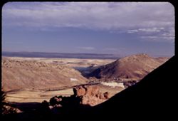
- Description:
- 25 f 6.3 Pola
- Subject:
- Deserts, Cliffs, Colorado National Monument (Colo.), Mesas, Buttes, Mountains, Shrubs, Clouds, Roads, Trees, and National parks & reserves
- Series:
- 26-52
- Creator:
- Cushman, Charles W., 1896-1972
- Date Created:
- 1952-11-03
- Genre:
- Landscape photographs
- Frame Number:
- 5
- County:
- Mesa
- Abstract:
- View over Grnd Juctn.
- Call Number:
- P06412
- City:
- Grand Junction
- Country:
- United States
- State/Province:
- Colorado
- Alternate Identifier:
- 2652.5
- Persistent URL:
- http://purl.dlib.indiana.edu/iudl/archives/cushman/P06412
- Holding Location:
- Bloomington - University Archives
Wells Library E460
1320 E 10th St.
Bloomington, IN 47405
Contact at archives@indiana.edu, 812-855-1127
-

- Description:
- 25 f 6 POLA
- Subject:
- Rocks, Roads, Parks, Boulders, Shadows, Buttes, Mountains, Buildings, Rock formations, Clouds, Red Rocks Park (Jefferson County, Colo.), Hills, and Cliffs
- Series:
- 24-52
- Creator:
- Cushman, Charles W., 1896-1972
- Date Created:
- 1952-10-30
- Genre:
- Landscape photographs
- Frame Number:
- 5
- County:
- Jefferson
- Abstract:
- Red Rock Park west of Denver
- Call Number:
- P06336
- City:
- Morrison
- Country:
- United States
- State/Province:
- Colorado
- Alternate Identifier:
- 2452.5
- Persistent URL:
- http://purl.dlib.indiana.edu/iudl/archives/cushman/P06336
- Holding Location:
- Bloomington - University Archives
Wells Library E460
1320 E 10th St.
Bloomington, IN 47405
Contact at archives@indiana.edu, 812-855-1127
-
- Description:
- 25 f 9
- Subject:
- Rocky Mountains, Roads, Trees, Mummy Range (Colo.), Tree limbs, Mountains, National parks & reserves, Clouds, Forests, Rocky Mountain National Park (Colo...
- Series:
- 24-52
- Creator:
- Cushman, Charles W., 1896-1972
- Date Created:
- 1952-11-01
- Genre:
- Landscape photographs
- Frame Number:
- 37
- County:
- Larimer
- Abstract:
- Mummy Mtns to NW of Hwy.
- Call Number:
- P06368
- Country:
- United States
- State/Province:
- Colorado
- Alternate Identifier:
- 2452.37
- Persistent URL:
- http://purl.dlib.indiana.edu/iudl/archives/cushman/P06368
- Holding Location:
- Bloomington - University Archives
Wells Library E460
1320 E 10th St.
Bloomington, IN 47405
Contact at archives@indiana.edu, 812-855-1127
-
- Description:
- 50 f 8 Pola
- Subject:
- Passes (Landforms), Roads, Mountains, Shrubs, Snow, Trees, Rocks, Kenosha Pass (Colo.), Railings, Kenosha Mountains (Colo.), and Clouds
- Series:
- 10-53
- Creator:
- Cushman, Charles W., 1896-1972
- Date Created:
- 1953-10-14
- Genre:
- Landscape photographs
- Frame Number:
- 22
- County:
- Park
- Abstract:
- NE from Kenosha Pass
- Call Number:
- P06862
- Country:
- United States
- State/Province:
- Colorado
- Alternate Identifier:
- 1053.22
- Persistent URL:
- http://purl.dlib.indiana.edu/iudl/archives/cushman/P06862
- Holding Location:
- Bloomington - University Archives
Wells Library E460
1320 E 10th St.
Bloomington, IN 47405
Contact at archives@indiana.edu, 812-855-1127
-
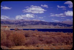
- Description:
- 50 f 11
- Subject:
- Reservoirs, Houses, Trees, Mountains, Shrubs, Lakes & ponds, Clouds, Twin Lakes Reservoir (Lake County, Colo.), Hills, Grasses, and Waterfronts
- Series:
- 11-53
- Creator:
- Cushman, Charles W., 1896-1972
- Date Created:
- 1953-10-15
- Genre:
- Landscape photographs
- Frame Number:
- 16
- County:
- Lake
- Abstract:
- The bigger Twin Lakes
- Call Number:
- P06895
- City:
- Leadville
- Country:
- United States
- State/Province:
- Colorado
- Alternate Identifier:
- 1153.16
- Persistent URL:
- http://purl.dlib.indiana.edu/iudl/archives/cushman/P06895
- Holding Location:
- Bloomington - University Archives
Wells Library E460
1320 E 10th St.
Bloomington, IN 47405
Contact at archives@indiana.edu, 812-855-1127
-
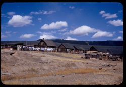
- Description:
- 50 f 11
- Subject:
- Rocks, Grasses, Houses, Dirt, Mountains, Clotheslines, Clouds, Suburbs, Wooden buildings, Suburban life, and Laundry
- Series:
- 11-53
- Creator:
- Cushman, Charles W., 1896-1972
- Date Created:
- 1953-10-15
- Genre:
- Cityscape photographs
- Frame Number:
- 8
- County:
- Lake
- Abstract:
- Stringtown nr Leadville
- Call Number:
- P06887
- City:
- Stringtown and Leadville
- Country:
- United States
- State/Province:
- Colorado
- Alternate Identifier:
- 1153.8
- Persistent URL:
- http://purl.dlib.indiana.edu/iudl/archives/cushman/P06887
- Holding Location:
- Bloomington - University Archives
Wells Library E460
1320 E 10th St.
Bloomington, IN 47405
Contact at archives@indiana.edu, 812-855-1127
-
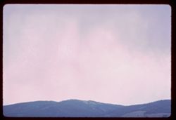
- Description:
- 100 f 4.5
- Subject:
- Rocky Mountains, Mountains, Clouds, and Hills
- Series:
- 9-66
- Creator:
- Cushman, Charles W., 1896-1972
- Date Created:
- 1966-06-15
- Genre:
- Landscape photographs
- Frame Number:
- 29
- County:
- Grand
- Call Number:
- P15432
- City:
- Granby
- Country:
- United States
- State/Province:
- Colorado
- Physical Description:
- fingerprint.
- Alternate Identifier:
- 966.29
- Persistent URL:
- http://purl.dlib.indiana.edu/iudl/archives/cushman/P15432
- Holding Location:
- Bloomington - University Archives
Wells Library E460
1320 E 10th St.
Bloomington, IN 47405
Contact at archives@indiana.edu, 812-855-1127