
Search Constraints
You searched for:
Campus
IUB
Remove constraint Campus: IUB
County
Contra Costa
Remove constraint County: Contra Costa
Creator
Cushman, Charles W., 1896-1972
Remove constraint Creator: Cushman, Charles W., 1896-1972
Subject
Hills
Remove constraint Subject: Hills
« Previous |
1 - 50 of 70
|
Next »
Search Results
-
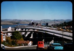
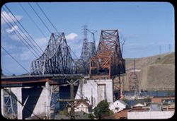
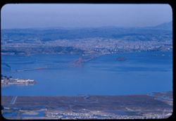
- Description:
- 50 f 8 sl
- Subject:
- Channels, Factories, Automobiles, Bridge construction, Roofs, Streets, Carquinez Strait (Calif.), Express highways, Dwellings, Hills, Smokestacks, Road const...
- Series:
- 16-57
- Creator:
- Cushman, Charles W., 1896-1972
- Date Created:
- 1957-11-14
- Genre:
- Snapshots, Views, Cityscape photographs, and Architectural photographs
- Frame Number:
- 18
- County:
- Contra Costa
- Abstract:
- New freeway unfinished
- Call Number:
- P15809
- City:
- Crockett
- Country:
- United States
- State/Province:
- California
- Alternate Identifier:
- 1657.18
- Persistent URL:
- http://purl.dlib.indiana.edu/iudl/archives/cushman/P15809
- Holding Location:
- Bloomington - University Archives
Wells Library E460
1320 E 10th St.
Bloomington, IN 47405
Contact at archives@indiana.edu, 812-855-1127
-
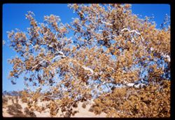
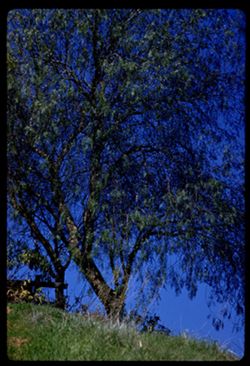
- Description:
- 50 f 6.3 sl
- Subject:
- Leaves, Tree limbs, Marsh Creek (Contra Costa County, Calif.), Hills, and Sycamores
- Series:
- 25-60
- Creator:
- Cushman, Charles W., 1896-1972
- Date Created:
- 1960-10-25
- Genre:
- Identification photographs
- Frame Number:
- 36
- County:
- Contra Costa
- Abstract:
- Top of sycamore
- Call Number:
- P11722
- Country:
- United States
- State/Province:
- California
- Alternate Identifier:
- 2560.36
- Persistent URL:
- http://purl.dlib.indiana.edu/iudl/archives/cushman/P11722
- Holding Location:
- Bloomington - University Archives
Wells Library E460
1320 E 10th St.
Bloomington, IN 47405
Contact at archives@indiana.edu, 812-855-1127
-
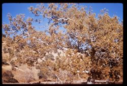
- Description:
- 50 f 6.3
- Subject:
- Marsh Creek (Contra Costa County, Calif.), Hills, Sycamores, Autumn, Trees, and Streams
- Series:
- 25-60
- Creator:
- Cushman, Charles W., 1896-1972
- Date Created:
- 1960-10-25
- Genre:
- Identification photographs
- Frame Number:
- 35
- County:
- Contra Costa
- Abstract:
- Sycamore across creek by sycamore
- Call Number:
- P11721
- Country:
- United States
- State/Province:
- California
- Alternate Identifier:
- 2560.35
- Persistent URL:
- http://purl.dlib.indiana.edu/iudl/archives/cushman/P11721
- Holding Location:
- Bloomington - University Archives
Wells Library E460
1320 E 10th St.
Bloomington, IN 47405
Contact at archives@indiana.edu, 812-855-1127
-
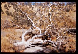
- Description:
- 50 f 8 sl
- Subject:
- Rocks, Sycamores, Trees, Marsh Creek (Contra Costa County, Calif.), Hills, and Streams
- Series:
- 25-60
- Creator:
- Cushman, Charles W., 1896-1972
- Date Created:
- 1960-10-25
- Genre:
- Identification photographs
- Frame Number:
- 34
- County:
- Contra Costa
- Abstract:
- Sycamore across creek
- Call Number:
- P11720
- Country:
- United States
- State/Province:
- California
- Alternate Identifier:
- 2560.34
- Persistent URL:
- http://purl.dlib.indiana.edu/iudl/archives/cushman/P11720
- Holding Location:
- Bloomington - University Archives
Wells Library E460
1320 E 10th St.
Bloomington, IN 47405
Contact at archives@indiana.edu, 812-855-1127
-
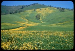
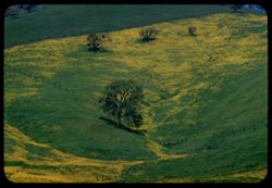
- Description:
- 50 f 9 SL
- Subject:
- Grasses, Trees, Flowers, Meadows, Fences, Hills, and Mustard (Plant)
- Series:
- 2-60
- Creator:
- Cushman, Charles W., 1896-1972
- Date Created:
- 1960-03-25
- Genre:
- Landscape photographs
- Frame Number:
- 30
- County:
- Contra Costa
- Abstract:
- Mustard & grass SE of Clayton
- Call Number:
- P10961
- City:
- Clayton
- Country:
- United States
- State/Province:
- California
- Alternate Identifier:
- 260.30
- Persistent URL:
- http://purl.dlib.indiana.edu/iudl/archives/cushman/P10961
- Holding Location:
- Bloomington - University Archives
Wells Library E460
1320 E 10th St.
Bloomington, IN 47405
Contact at archives@indiana.edu, 812-855-1127
-
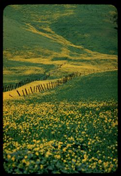
- Description:
- 100 f 8 TL
- Subject:
- Grasses, Flowers, Meadows, Fences, Hills, and Mustard (Plant)
- Series:
- 2-60
- Creator:
- Cushman, Charles W., 1896-1972
- Date Created:
- 1960-03-25
- Genre:
- Landscape photographs
- Frame Number:
- 29
- County:
- Contra Costa
- Abstract:
- Mustard & grass SE of Clayton
- Call Number:
- P10960
- City:
- Clayton
- Country:
- United States
- State/Province:
- California
- Alternate Identifier:
- 260.29
- Persistent URL:
- http://purl.dlib.indiana.edu/iudl/archives/cushman/P10960
- Holding Location:
- Bloomington - University Archives
Wells Library E460
1320 E 10th St.
Bloomington, IN 47405
Contact at archives@indiana.edu, 812-855-1127
-
- Description:
- 100 f 8 TL
- Subject:
- Diablo, Mount (Calif.), Meadows, Flowers, Hills, Mustard (Plant), Mountains, Trees, Grasses, and Fences
- Series:
- 2-60
- Creator:
- Cushman, Charles W., 1896-1972
- Date Created:
- 1960-03-25
- Genre:
- Landscape photographs
- Frame Number:
- 28
- County:
- Contra Costa
- Abstract:
- Mustard & grass SE of Clayton
- Call Number:
- P10959
- City:
- Clayton
- Country:
- United States
- State/Province:
- California
- Alternate Identifier:
- 260.28
- Persistent URL:
- http://purl.dlib.indiana.edu/iudl/archives/cushman/P10959
- Holding Location:
- Bloomington - University Archives
Wells Library E460
1320 E 10th St.
Bloomington, IN 47405
Contact at archives@indiana.edu, 812-855-1127
-
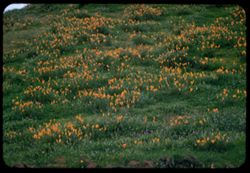
- Description:
- 100 f 4.5 TL
- Subject:
- California poppies, Alhambra Valley (Calif.), Meadows, Valleys, Hills, Grasses, and Wildflowers
- Series:
- 2-60
- Creator:
- Cushman, Charles W., 1896-1972
- Date Created:
- 1960-03-25
- Genre:
- Landscape photographs
- Frame Number:
- 27
- County:
- Contra Costa
- Abstract:
- Poppies on a green hillside Alhambra Valley
- Call Number:
- P10958
- Country:
- United States
- State/Province:
- California
- Alternate Identifier:
- 260.27
- Persistent URL:
- http://purl.dlib.indiana.edu/iudl/archives/cushman/P10958
- Holding Location:
- Bloomington - University Archives
Wells Library E460
1320 E 10th St.
Bloomington, IN 47405
Contact at archives@indiana.edu, 812-855-1127
-
- Description:
- 100 f 6.3 TL
- Subject:
- Grasses, Pepper-tree, Trees, Fences, and Hills
- Series:
- 1-60
- Creator:
- Cushman, Charles W., 1896-1972
- Date Created:
- 1960-02-16
- Genre:
- Identification photographs
- Frame Number:
- 21
- County:
- Contra Costa
- Abstract:
- Pepper tree at hill top
- Call Number:
- P10915
- City:
- Port Costa
- Country:
- United States
- State/Province:
- California
- Alternate Identifier:
- 160.21
- Persistent URL:
- http://purl.dlib.indiana.edu/iudl/archives/cushman/P10915
- Holding Location:
- Bloomington - University Archives
Wells Library E460
1320 E 10th St.
Bloomington, IN 47405
Contact at archives@indiana.edu, 812-855-1127
-
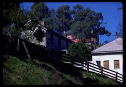
- Description:
- 100 f 5.6 tl
- Subject:
- Chimneys, Hills, Windows, Trees, Grasses, Fences, and Houses
- Series:
- 1-60
- Creator:
- Cushman, Charles W., 1896-1972
- Date Created:
- 1960-02-16
- Genre:
- Landscape photographs
- Frame Number:
- 20
- County:
- Contra Costa
- Abstract:
- Hill top at Port Costa 24,400 miles
- Call Number:
- P10914
- City:
- Port Costa
- Country:
- United States
- State/Province:
- California
- Alternate Identifier:
- 160.20
- Persistent URL:
- http://purl.dlib.indiana.edu/iudl/archives/cushman/P10914
- Holding Location:
- Bloomington - University Archives
Wells Library E460
1320 E 10th St.
Bloomington, IN 47405
Contact at archives@indiana.edu, 812-855-1127
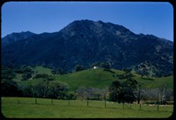
-
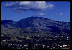
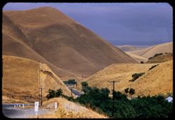
- Description:
- 100 f 8 tl
- Subject:
- Trees, Diablo, Mount (Calif.), Mountains, Buildings, Clouds, and Hills
- Series:
- 1-60
- Creator:
- Cushman, Charles W., 1896-1972
- Date Created:
- 1960-01-12
- Genre:
- Landscape photographs and Cityscape photographs
- Frame Number:
- 2
- Street Address:
- Kirker Pass Road
- County:
- Contra Costa
- Abstract:
- Toward Mt D. from Kirker Pass road From hts west of Walnut Creek toward Diablo
- Call Number:
- P10896
- City:
- Walnut Creek
- Country:
- United States
- State/Province:
- California
- Alternate Identifier:
- 160.2
- Persistent URL:
- http://purl.dlib.indiana.edu/iudl/archives/cushman/P10896
- Holding Location:
- Bloomington - University Archives
Wells Library E460
1320 E 10th St.
Bloomington, IN 47405
Contact at archives@indiana.edu, 812-855-1127
-
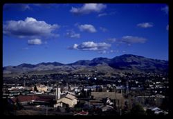
- Description:
- 100 f 8 sl
- Subject:
- Diablo, Mount (Calif.), Hills, Mountains, Trees, Buildings, and Clouds
- Series:
- 1-60
- Creator:
- Cushman, Charles W., 1896-1972
- Date Created:
- 1960-01-12
- Genre:
- Landscape photographs and Cityscape photographs
- Frame Number:
- 1
- Street Address:
- Kirker Pass Road
- County:
- Contra Costa
- Abstract:
- Toward Mt D. from Kirker Pass road From hts west of Walnut Creek toward Diablo
- Call Number:
- P10895
- City:
- Walnut Creek
- Country:
- United States
- State/Province:
- California
- Alternate Identifier:
- 160.1
- Persistent URL:
- http://purl.dlib.indiana.edu/iudl/archives/cushman/P10895
- Holding Location:
- Bloomington - University Archives
Wells Library E460
1320 E 10th St.
Bloomington, IN 47405
Contact at archives@indiana.edu, 812-855-1127
-
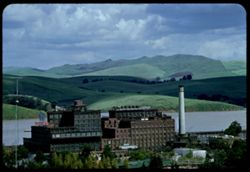
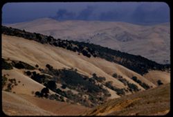
- Description:
- 100 f 6.3 tl
- Subject:
- Refineries, Sugar industry, Trees, Meadows, Buildings, California and Hawaiian Sugar Company, Clouds, Hills, Smokestacks, and Carquinez Strait (Calif.)
- Series:
- 2-58
- Creator:
- Cushman, Charles W., 1896-1972
- Date Created:
- 1958-04-01
- Genre:
- Landscape photographs
- Frame Number:
- 20
- County:
- Contra Costa and Solano
- Abstract:
- Sugarmill and Solano hills beyond Carquinez Str.
- Call Number:
- P09715
- City:
- Crockett
- Country:
- United States
- State/Province:
- California
- Alternate Identifier:
- 258.20
- Persistent URL:
- http://purl.dlib.indiana.edu/iudl/archives/cushman/P09715
- Holding Location:
- Bloomington - University Archives
Wells Library E460
1320 E 10th St.
Bloomington, IN 47405
Contact at archives@indiana.edu, 812-855-1127
-
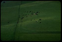
- Description:
- 100 F 8 TL
- Subject:
- Meadows, Hills, Cattle, Kirker Pass (Calif.), and Grazing
- Series:
- 1-58
- Creator:
- Cushman, Charles W., 1896-1972
- Date Created:
- 1958-02-26
- Genre:
- Landscape photographs
- Frame Number:
- 32
- County:
- Contra Costa
- Abstract:
- Cattle again
- Call Number:
- P09690
- Country:
- United States
- State/Province:
- California
- Alternate Identifier:
- 158.32
- Persistent URL:
- http://purl.dlib.indiana.edu/iudl/archives/cushman/P09690
- Holding Location:
- Bloomington - University Archives
Wells Library E460
1320 E 10th St.
Bloomington, IN 47405
Contact at archives@indiana.edu, 812-855-1127
-
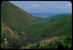
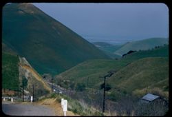
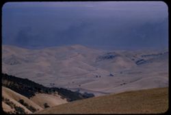
- Description:
- 100 f 8 tl
- Subject:
- Kirker Pass (Calif.), Roads, Trees, Meadows, Clouds, Passes (Landforms), Utility poles, and Hills
- Series:
- 1-58
- Creator:
- Cushman, Charles W., 1896-1972
- Date Created:
- 1958-02-26
- Genre:
- Landscape photographs
- Frame Number:
- 31
- County:
- Contra Costa
- Abstract:
- View toward delta
- Call Number:
- P09689
- Country:
- United States
- State/Province:
- California
- Alternate Identifier:
- 158.31
- Persistent URL:
- http://purl.dlib.indiana.edu/iudl/archives/cushman/P09689
- Holding Location:
- Bloomington - University Archives
Wells Library E460
1320 E 10th St.
Bloomington, IN 47405
Contact at archives@indiana.edu, 812-855-1127
-
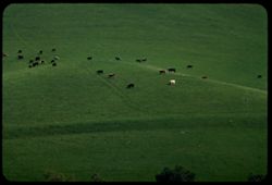
- Description:
- 100 f 6.3 tl
- Subject:
- Kirker Pass (Calif.), Grazing, Meadows, Cattle, and Hills
- Series:
- 1-58
- Creator:
- Cushman, Charles W., 1896-1972
- Date Created:
- 1958-02-20
- Genre:
- Landscape photographs
- Frame Number:
- 30
- County:
- Contra Costa
- Abstract:
- Cattle on green hillside
- Call Number:
- P09688
- Country:
- United States
- State/Province:
- California
- Alternate Identifier:
- 158.30
- Persistent URL:
- http://purl.dlib.indiana.edu/iudl/archives/cushman/P09688
- Holding Location:
- Bloomington - University Archives
Wells Library E460
1320 E 10th St.
Bloomington, IN 47405
Contact at archives@indiana.edu, 812-855-1127
-

- Description:
- 100 f 5.6 tl
- Subject:
- Channels, M.V. Carquinez (Ferry), Hills, Mountains, Carquinez Strait (Calif.), and Ferries
- Series:
- 18-57
- Creator:
- Cushman, Charles W., 1896-1972
- Date Created:
- 1957-12-25
- Genre:
- Marine photographs
- Frame Number:
- 30
- County:
- Solano and Contra Costa
- Abstract:
- Ferry Carquinez approaches Martinez
- Call Number:
- P09653
- City:
- Benicia and Martinez
- Country:
- United States
- State/Province:
- California
- Alternate Identifier:
- 1857.30
- Persistent URL:
- http://purl.dlib.indiana.edu/iudl/archives/cushman/P09653
- Holding Location:
- Bloomington - University Archives
Wells Library E460
1320 E 10th St.
Bloomington, IN 47405
Contact at archives@indiana.edu, 812-855-1127
-
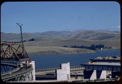
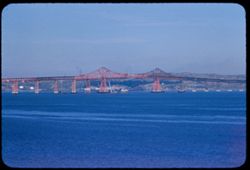
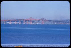
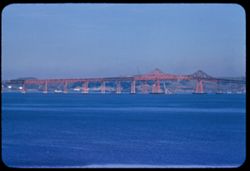
- Description:
- 100 f 6.3 tl
- Subject:
- Trestles, Channels, Electric lines, Road construction, Bridge construction, Carquinez Strait (Calif.), Express highways, Hills, Hoisting machinery, and Houses
- Series:
- 16-57
- Creator:
- Cushman, Charles W., 1896-1972
- Date Created:
- 1957-11-14
- Genre:
- Snapshots, Views, and Architectural photographs
- Frame Number:
- 26
- County:
- Contra Costa
- Abstract:
- Twin bridges Carquinez
- Call Number:
- P09591
- City:
- Crockett
- Country:
- United States
- State/Province:
- California
- Alternate Identifier:
- 1657.26
- Persistent URL:
- http://purl.dlib.indiana.edu/iudl/archives/cushman/P09591
- Holding Location:
- Bloomington - University Archives
Wells Library E460
1320 E 10th St.
Bloomington, IN 47405
Contact at archives@indiana.edu, 812-855-1127
-
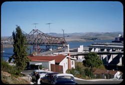
- Description:
- 100 f 8 tl
- Subject:
- Channels, Hoisting machinery, Road construction, Warehouses, Bridge construction, Streets, Bridges, Trucks, Hills, Automobiles, Meadows, Carquinez Strait (Ca...
- Series:
- 16-57
- Creator:
- Cushman, Charles W., 1896-1972
- Date Created:
- 1957-11-14
- Genre:
- Landscape photographs, Snapshots, Views, and Architectural photographs
- Frame Number:
- 25
- County:
- Contra Costa and Solano
- Abstract:
- Solano county hills across Carquinez
- Call Number:
- P09590
- City:
- Crockett
- Country:
- United States
- State/Province:
- California
- Alternate Identifier:
- 1657.25
- Persistent URL:
- http://purl.dlib.indiana.edu/iudl/archives/cushman/P09590
- Holding Location:
- Bloomington - University Archives
Wells Library E460
1320 E 10th St.
Bloomington, IN 47405
Contact at archives@indiana.edu, 812-855-1127
-
- Description:
- 50 f 8 sl
- Subject:
- Channels, Road construction, Automobiles, Bridge construction, Roofs, Streets, Carquinez Strait (Calif.), Express highways, Dwellings, Hills, and Bridges
- Series:
- 16-57
- Creator:
- Cushman, Charles W., 1896-1972
- Date Created:
- 1957-11-14
- Genre:
- Views and Architectural photographs
- Frame Number:
- 19
- County:
- Contra Costa
- Abstract:
- Unfinished concrete approaches at south end of new & old bridge
- Call Number:
- P09584
- City:
- Crockett
- Country:
- United States
- State/Province:
- California
- Alternate Identifier:
- 1657.19
- Persistent URL:
- http://purl.dlib.indiana.edu/iudl/archives/cushman/P09584
- Holding Location:
- Bloomington - University Archives
Wells Library E460
1320 E 10th St.
Bloomington, IN 47405
Contact at archives@indiana.edu, 812-855-1127
-
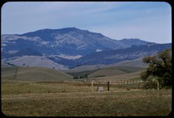
- Description:
- 100 f 6.3 tl
- Subject:
- Trees, Meadows, Mountains, Hills, and Diablo, Mount (Calif.)
- Series:
- 16-57
- Creator:
- Cushman, Charles W., 1896-1972
- Date Created:
- 1957-11-09
- Genre:
- Landscape photographs
- Frame Number:
- 13
- Street Address:
- Tassajara Road and Dougherty Road
- County:
- Contra Costa
- Abstract:
- Mount Diablo from junction with Tassajara rd.
- Call Number:
- P09579
- Country:
- United States
- State/Province:
- California
- Alternate Identifier:
- 1657.13
- Persistent URL:
- http://purl.dlib.indiana.edu/iudl/archives/cushman/P09579
- Holding Location:
- Bloomington - University Archives
Wells Library E460
1320 E 10th St.
Bloomington, IN 47405
Contact at archives@indiana.edu, 812-855-1127
-
- Description:
- 100 f 6.3 tl
- Subject:
- Barbed wire, Diablo, Mount (Calif.), Tree limbs, Mountains, Fences, Hills, and Meadows
- Series:
- 16-57
- Creator:
- Cushman, Charles W., 1896-1972
- Date Created:
- 1957-11-09
- Genre:
- Landscape photographs
- Frame Number:
- 12
- Street Address:
- Dougherty Road
- County:
- Contra Costa
- Abstract:
- Mount Diablo from south along Dougherty rd. from farther north Car mileage 200,222)
- Call Number:
- P09578
- Country:
- United States
- State/Province:
- California
- Alternate Identifier:
- 1657.12
- Persistent URL:
- http://purl.dlib.indiana.edu/iudl/archives/cushman/P09578
- Holding Location:
- Bloomington - University Archives
Wells Library E460
1320 E 10th St.
Bloomington, IN 47405
Contact at archives@indiana.edu, 812-855-1127
-
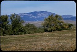
- Description:
- 100 f 6.3 tl
- Subject:
- Trees, Diablo, Mount (Calif.), Mountains, Hills, and Meadows
- Series:
- 16-57
- Creator:
- Cushman, Charles W., 1896-1972
- Date Created:
- 1957-11-09
- Genre:
- Landscape photographs
- Frame Number:
- 11
- Street Address:
- Dougherty Road
- County:
- Contra Costa
- Abstract:
- Mount Diablo from south along Dougherty rd.
- Call Number:
- P09577
- Country:
- United States
- State/Province:
- California
- Alternate Identifier:
- 1657.11
- Persistent URL:
- http://purl.dlib.indiana.edu/iudl/archives/cushman/P09577
- Holding Location:
- Bloomington - University Archives
Wells Library E460
1320 E 10th St.
Bloomington, IN 47405
Contact at archives@indiana.edu, 812-855-1127
-
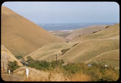
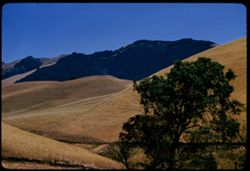
- Description:
- 100 f 8 tl
- Subject:
- Meadows, Valleys, Hills, Roads, and Kirker Pass (Calif.)
- Series:
- 16-57
- Creator:
- Cushman, Charles W., 1896-1972
- Date Created:
- 1957-10-28
- Genre:
- Landscape photographs
- Frame Number:
- 1
- County:
- Contra Costa
- Abstract:
- Contra Costa hills from Kirker Pass
- Call Number:
- P09567
- Country:
- United States
- State/Province:
- California
- Alternate Identifier:
- 1657.1
- Persistent URL:
- http://purl.dlib.indiana.edu/iudl/archives/cushman/P09567
- Holding Location:
- Bloomington - University Archives
Wells Library E460
1320 E 10th St.
Bloomington, IN 47405
Contact at archives@indiana.edu, 812-855-1127
-
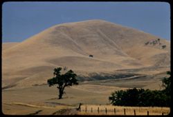
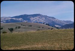
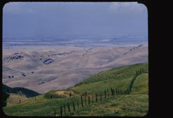
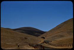
- Description:
- 100 f 8 tl
- Subject:
- Barbed wire, Trees, Meadows, Fences, and Hills
- Series:
- 10-57
- Creator:
- Cushman, Charles W., 1896-1972
- Date Created:
- 1957-06-27
- Genre:
- Landscape photographs
- Frame Number:
- 12
- Street Address:
- Kirker Pass Road
- County:
- Contra Costa
- Abstract:
- Contra Costa dry hills - from Kirker Pass Rd.
- Call Number:
- P09386
- Country:
- United States
- State/Province:
- California
- Alternate Identifier:
- 1057.12
- Persistent URL:
- http://purl.dlib.indiana.edu/iudl/archives/cushman/P09386
- Holding Location:
- Bloomington - University Archives
Wells Library E460
1320 E 10th St.
Bloomington, IN 47405
Contact at archives@indiana.edu, 812-855-1127
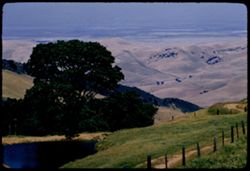
-
- Description:
- 100 f 8 tl
- Subject:
- Kirker Pass (Calif.), Valleys, Meadows, Plains, and Hills
- Series:
- 9-57
- Creator:
- Cushman, Charles W., 1896-1972
- Date Created:
- 1957-06-15
- Genre:
- Landscape photographs
- Frame Number:
- 2
- County:
- Contra Costa
- Abstract:
- NE from Kirker Pass
- Call Number:
- P09339
- Country:
- United States
- State/Province:
- California
- Alternate Identifier:
- 957.2
- Persistent URL:
- http://purl.dlib.indiana.edu/iudl/archives/cushman/P09339
- Holding Location:
- Bloomington - University Archives
Wells Library E460
1320 E 10th St.
Bloomington, IN 47405
Contact at archives@indiana.edu, 812-855-1127
-
- Description:
- 100 f 6.3 tl
- Subject:
- Valleys, Farms, Diablo, Mount (Calif.), Croplands, Hills, and Meadows
- Series:
- 8-57
- Creator:
- Cushman, Charles W., 1896-1972
- Date Created:
- 1957-06-15
- Genre:
- Landscape photographs
- Frame Number:
- 21
- Street Address:
- Morgan Terrace Road
- County:
- Contra Costa
- Abstract:
- Similar-from higher
- Call Number:
- P09337
- Country:
- United States
- State/Province:
- California
- Physical Description:
- masked.
- Alternate Identifier:
- 857.21
- Persistent URL:
- http://purl.dlib.indiana.edu/iudl/archives/cushman/P09337
- Holding Location:
- Bloomington - University Archives
Wells Library E460
1320 E 10th St.
Bloomington, IN 47405
Contact at archives@indiana.edu, 812-855-1127
-
- Description:
- 100 f 6.3 tl
- Subject:
- Valleys, Farms, Barbed wire, Meadows, Croplands, Fences, Hay, Hills, Haystacks, and Diablo, Mount (Calif.)
- Series:
- 8-57
- Creator:
- Cushman, Charles W., 1896-1972
- Date Created:
- 1957-06-15
- Genre:
- Landscape photographs
- Frame Number:
- 20
- Street Address:
- Morgan Territory Road
- County:
- Contra Costa
- Abstract:
- View from east & west from Morgan Terr. Road
- Call Number:
- P09336
- Country:
- United States
- State/Province:
- California
- Alternate Identifier:
- 857.20
- Persistent URL:
- http://purl.dlib.indiana.edu/iudl/archives/cushman/P09336
- Holding Location:
- Bloomington - University Archives
Wells Library E460
1320 E 10th St.
Bloomington, IN 47405
Contact at archives@indiana.edu, 812-855-1127
-
- Description:
- 100 f 6.3
- Subject:
- Meadows, Diablo, Mount (Calif.), Hills, Grasses, and Trees
- Series:
- 8-57
- Creator:
- Cushman, Charles W., 1896-1972
- Date Created:
- 1957-06-15
- Genre:
- Landscape photographs
- Frame Number:
- 19
- Street Address:
- Morgan Territory Road
- County:
- Contra Costa
- Abstract:
- Hills along Morgan Terr. Road
- Call Number:
- P09335
- Country:
- United States
- State/Province:
- California
- Alternate Identifier:
- 857.19
- Persistent URL:
- http://purl.dlib.indiana.edu/iudl/archives/cushman/P09335
- Holding Location:
- Bloomington - University Archives
Wells Library E460
1320 E 10th St.
Bloomington, IN 47405
Contact at archives@indiana.edu, 812-855-1127
-
- Description:
- 100 f 6.3 tl
- Subject:
- Valleys, Trees, Diablo, Mount (Calif.), Hills, and Meadows
- Series:
- 8-57
- Creator:
- Cushman, Charles W., 1896-1972
- Date Created:
- 1957-06-15
- Genre:
- Landscape photographs
- Frame Number:
- 18
- County:
- Contra Costa
- Abstract:
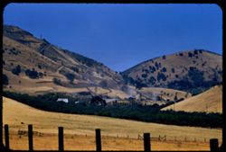
- Contra Costa county=Searched mouth in
- Call Number:
- P09334
- Country:
- United States
- State/Province:
- California
- Alternate Identifier:
- 857.18
- Persistent URL:
- http://purl.dlib.indiana.edu/iudl/archives/cushman/P09334
- Holding Location:
- Bloomington - University Archives
Wells Library E460
1320 E 10th St.
Bloomington, IN 47405
Contact at archives@indiana.edu, 812-855-1127
-
- Description:
- 100 f 8 tl
- Subject:
- Valleys, Barbed wire, Meadows, Fences, Hills, and Diablo, Mount (Calif.)
- Series:
- 7-57
- Creator:
- Cushman, Charles W., 1896-1972
- Date Created:
- 1957-05-31
- Genre:
- Landscape photographs
- Frame Number:
- 36
- County:
- Contra Costa
- Abstract:
- Toward foothills and hazy valley east of Mount Diablo
- Call Number:
- P09315
- Country:
- United States
- State/Province:
- California
- Physical Description:
- masked.
- Alternate Identifier:
- 757.36
- Persistent URL:
- http://purl.dlib.indiana.edu/iudl/archives/cushman/P09315
- Holding Location:
- Bloomington - University Archives
Wells Library E460
1320 E 10th St.
Bloomington, IN 47405
Contact at archives@indiana.edu, 812-855-1127
-
- Description:
- 100 f 8 tl ®
- Subject:
- Valleys, Barbed wire, Trees, Meadows, Plains, Fences, Hills, and Diablo, Mount (Calif.)
- Series:
- 7-57
- Creator:
- Cushman, Charles W., 1896-1972
- Date Created:
- 1957-05-31
- Genre:
- Landscape photographs
- Frame Number:
- 35
- County:
- Contra Costa
- Abstract:
- Toward foothills and hazy valley east of Mount Diablo
- Call Number:
- P09314
- Country:
- United States
- State/Province:
- California
- Alternate Identifier:
- 757.35
- Persistent URL:
- http://purl.dlib.indiana.edu/iudl/archives/cushman/P09314
- Holding Location:
- Bloomington - University Archives
Wells Library E460
1320 E 10th St.
Bloomington, IN 47405
Contact at archives@indiana.edu, 812-855-1127
-
- Description:
- 100 f 6.3 sl
- Subject:
- Croplands, Meadows, Caterpillar Tractor Company, Hills, Agricultural machinery & implements, Hay, Farms, and Tractors
- Series:
- 7-57
- Creator:
- Cushman, Charles W., 1896-1972
- Date Created:
- 1957-05-31
- Genre:
- Landscape photographs
- Frame Number:
- 34
- Street Address:
- Marsh Creek Road
- County:
- Contra Costa
- Abstract:
- More Caterpillars from Marsh Creek road
- Call Number:
- P09313
- Country:
- United States
- State/Province:
- California
- Alternate Identifier:
- 757.34
- Persistent URL:
- http://purl.dlib.indiana.edu/iudl/archives/cushman/P09313
- Holding Location:
- Bloomington - University Archives
Wells Library E460
1320 E 10th St.
Bloomington, IN 47405
Contact at archives@indiana.edu, 812-855-1127
-
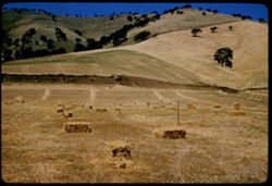
- Description:
- 100 f 8 sl
- Subject:
- Agricultural machinery & implements, Pitchforks, Meadows, Croplands, Caterpillar Tractor Company, Hills, Tractors, and Hay
- Series:
- 7-57
- Creator:
- Cushman, Charles W., 1896-1972
- Date Created:
- 1957-05-31
- Genre:
- Landscape photographs
- Frame Number:
- 33
- Street Address:
- Marsh Creek Road
- County:
- Contra Costa
- Abstract:
- Big Caterpiller machine and hills of Contra Costa county along Marsh Creek road
- Call Number:
- P09312
- Country:
- United States
- State/Province:
- California
- Alternate Identifier:
- 757.33
- Persistent URL:
- http://purl.dlib.indiana.edu/iudl/archives/cushman/P09312
- Holding Location:
- Bloomington - University Archives
Wells Library E460
1320 E 10th St.
Bloomington, IN 47405
Contact at archives@indiana.edu, 812-855-1127
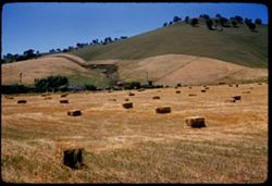
-
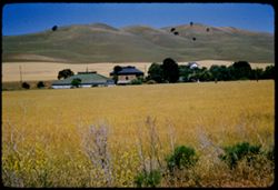
- Description:
- 100 f 6.3
- Subject:
- Meadows, Hills, Farmhouses, Outbuildings, Farms, and Grasses
- Series:
- 7-57
- Creator:
- Cushman, Charles W., 1896-1972
- Date Created:
- 1957-05-31
- Genre:
- Landscape photographs and Views
- Frame Number:
- 32
- County:
- Contra Costa
- Abstract:
- Contra Costa hills & farms near Clayton
- Call Number:
- P09311
- City:
- Clayton
- Country:
- United States
- State/Province:
- California
- Alternate Identifier:
- 757.32
- Persistent URL:
- http://purl.dlib.indiana.edu/iudl/archives/cushman/P09311
- Holding Location:
- Bloomington - University Archives
Wells Library E460
1320 E 10th St.
Bloomington, IN 47405
Contact at archives@indiana.edu, 812-855-1127
-
- Description:
- 100 f 8 tl
- Subject:
- Kirker Pass (Calif.), Valleys, Roads, Meadows, Mountains, Hills, and Utility poles
- Series:
- 2-57
- Creator:
- Cushman, Charles W., 1896-1972
- Date Created:
- 1957-03-27
- Genre:
- Landscape photographs
- Frame Number:
- 6
- County:
- Contra Costa
- Abstract:
- Contra Costa Hills - view N.E. from Kirker Pass
- Call Number:
- P09132
- Country:
- United States
- State/Province:
- California
- Alternate Identifier:
- 257.6
- Persistent URL:
- http://purl.dlib.indiana.edu/iudl/archives/cushman/P09132
- Holding Location:
- Bloomington - University Archives
Wells Library E460
1320 E 10th St.
Bloomington, IN 47405
Contact at archives@indiana.edu, 812-855-1127
-
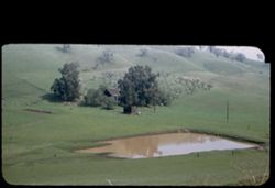
- Description:
- 50 f 5.6 sl
- Subject:
- Farmhouses, Outbuildings, Farms, Meadows, Croplands, Lakes & ponds, and Hills
- Series:
- 1-57
- Creator:
- Cushman, Charles W., 1896-1972
- Date Created:
- 1957-03-07
- Genre:
- Landscape photographs
- Frame Number:
- 5
- Street Address:
- Reliez Valley Road
- County:
- Contra Costa
- Abstract:
- Farm in Contra Costa county along Reliez Val. Rd.
- Call Number:
- P09111
- Country:
- United States
- State/Province:
- California
- Physical Description:
- masked.
- Alternate Identifier:
- 157.5
- Persistent URL:
- http://purl.dlib.indiana.edu/iudl/archives/cushman/P09111
- Holding Location:
- Bloomington - University Archives
Wells Library E460
1320 E 10th St.
Bloomington, IN 47405
Contact at archives@indiana.edu, 812-855-1127
-
- Description:
- 100 f 6.3 tl
- Subject:
- Horseback riding, Diablo, Mount (Calif.), Meadows, Valleys, Hills, Barbed wire, Roads, and Fences
- Series:
- 14-56
- Creator:
- Cushman, Charles W., 1896-1972
- Date Created:
- 1956-11-13
- Genre:
- Landscape photographs
- Frame Number:
- 28
- Street Address:
- Beck Road
- County:
- Contra Costa
- Abstract:
- View north up Beck road on overcast day Contra Costa county
- Call Number:
- P09025
- Country:
- United States
- State/Province:
- California
- Alternate Identifier:
- 1456.28
- Persistent URL:
- http://purl.dlib.indiana.edu/iudl/archives/cushman/P09025
- Holding Location:
- Bloomington - University Archives
Wells Library E460
1320 E 10th St.
Bloomington, IN 47405
Contact at archives@indiana.edu, 812-855-1127
-
- Description:
- 100 f 6.3 tl
- Subject:
- Valleys, Grasses, Barbed wire, Diablo, Mount (Calif.), Fences, Shrubs, Hills, and Meadows
- Series:
- 14-56
- Creator:
- Cushman, Charles W., 1896-1972
- Date Created:
- 1956-11-13
- Genre:
- Landscape photographs
- Frame Number:
- 27
- Street Address:
- Beck Road
- County:
- Contra Costa
- Abstract:
- Views E.ward from Beck road in Contra Costa county
- Call Number:
- P09024
- Country:
- United States
- State/Province:
- California
- Alternate Identifier:
- 1456.27
- Persistent URL:
- http://purl.dlib.indiana.edu/iudl/archives/cushman/P09024
- Holding Location:
- Bloomington - University Archives
Wells Library E460
1320 E 10th St.
Bloomington, IN 47405
Contact at archives@indiana.edu, 812-855-1127
-
- Description:
- 100 f 5.6 tl
- Subject:
- Grasses, Meadows, Shrubs, Hills, and Diablo, Mount (Calif.)
- Series:
- 14-56
- Creator:
- Cushman, Charles W., 1896-1972
- Date Created:
- 1956-11-13
- Genre:
- Landscape photographs
- Frame Number:
- 26
- Street Address:
- Beck Road
- County:
- Contra Costa
- Abstract:
- Views E.ward from Beck road in Contra Costa county
- Call Number:
- P09023
- Country:
- United States
- State/Province:
- California
- Alternate Identifier:
- 1456.26
- Persistent URL:
- http://purl.dlib.indiana.edu/iudl/archives/cushman/P09023
- Holding Location:
- Bloomington - University Archives
Wells Library E460
1320 E 10th St.
Bloomington, IN 47405
Contact at archives@indiana.edu, 812-855-1127
-
- Description:
- 100 f 8 tl
- Subject:
- Hills, Roads, Utility poles, and Trees
- Series:
- 8-56
- Creator:
- Cushman, Charles W., 1896-1972
- Date Created:
- 1956-06-29
- Genre:
- Landscape photographs
- Frame Number:
- 11
- Street Address:
- Kirker Pass Road
- County:
- Contra Costa
- Abstract:
- View NE down Kirker Pass road toward Pittsburg- Contra Costa co. very hot
- Call Number:
- P08795
- City:
- Pittsburg
- Country:
- United States
- State/Province:
- California
- Alternate Identifier:
- 856.11
- Persistent URL:
- http://purl.dlib.indiana.edu/iudl/archives/cushman/P08795
- Holding Location:
- Bloomington - University Archives
Wells Library E460
1320 E 10th St.
Bloomington, IN 47405
Contact at archives@indiana.edu, 812-855-1127
-
- Description:
- 100 f 8 tl
- Subject:
- Trees, Smoke, Diablo, Mount (Calif.), Fences, Hills, and Meadows
- Series:
- 8-56
- Creator:
- Cushman, Charles W., 1896-1972
- Date Created:
- 1956-06-29
- Genre:
- Landscape photographs
- Frame Number:
- 10
- Street Address:
- Pine Hollow Road
- County:
- Contra Costa
- Abstract:
- Contra Costa hills north of Mt Diablo from Pine Hollow rd nr. Clayton
- Call Number:
- P08794
- City:
- Clayton
- Country:
- United States
- State/Province:
- California
- Alternate Identifier:
- 856.10
- Persistent URL:
- http://purl.dlib.indiana.edu/iudl/archives/cushman/P08794
- Holding Location:
- Bloomington - University Archives
Wells Library E460
1320 E 10th St.
Bloomington, IN 47405
Contact at archives@indiana.edu, 812-855-1127
-
- Description:
- 100 f 5.6 sl
- Subject:
- Diablo, Mount (Calif.), Hills, Mountains, Trees, Fences, and North Peak (Contra Costa County, Calif.)
- Series:
- 3-56
- Creator:
- Cushman, Charles W., 1896-1972
- Date Created:
- 1956-04-02
- Genre:
- Landscape photographs
- Frame Number:
- 38
- County:
- Contra Costa
- Abstract:
- North PK from NE
- Call Number:
- P08639
- Country:
- United States
- State/Province:
- California
- Alternate Identifier:
- 356.38
- Persistent URL:
- http://purl.dlib.indiana.edu/iudl/archives/cushman/P08639
- Holding Location:
- Bloomington - University Archives
Wells Library E460
1320 E 10th St.
Bloomington, IN 47405
Contact at archives@indiana.edu, 812-855-1127
-
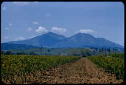
- Description:
- 100 f 6.3 tl
- Subject:
- Diablo, Mount (Calif.), Hills, Orchards, Mountains, Utility poles, Trees, Farms, and Clouds
- Series:
- 3-56
- Creator:
- Cushman, Charles W., 1896-1972
- Date Created:
- 1956-04-02
- Genre:
- Landscape photographs
- Frame Number:
- 37
- County:
- Contra Costa
- Abstract:
- Mt Diablo from east
- Call Number:
- P08638
- Country:
- United States
- State/Province:
- California
- Alternate Identifier:
- 356.37
- Persistent URL:
- http://purl.dlib.indiana.edu/iudl/archives/cushman/P08638
- Holding Location:
- Bloomington - University Archives
Wells Library E460
1320 E 10th St.
Bloomington, IN 47405
Contact at archives@indiana.edu, 812-855-1127
-
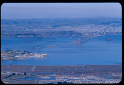
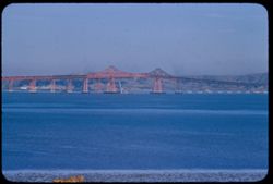
- Description:
- 100 f 8 tl
- Subject:
- Bays (Bodies of water), Richmond-San Rafael Bridge, Cities & towns, Bridges, Tamalpais, Mount (Calif.), Hills, and Canals
- Series:
- 2-56
- Creator:
- Cushman, Charles W., 1896-1972
- Date Created:
- 1956-03-14
- Genre:
- Landscape photographs and Cityscape photographs
- Frame Number:
- 18
- County:
- Marin and Contra Costa
- Abstract:
- San Rafael - Richm'd Bridge
- Call Number:
- P08584
- City:
- San Quentin, Richmond, and San Rafael
- Country:
- United States
- State/Province:
- California
- Alternate Identifier:
- 256.18
- Persistent URL:
- http://purl.dlib.indiana.edu/iudl/archives/cushman/P08584
- Holding Location:
- Bloomington - University Archives
Wells Library E460
1320 E 10th St.
Bloomington, IN 47405
Contact at archives@indiana.edu, 812-855-1127
-
- Description:
- 100 f 8 tl
- Subject:
- Bays (Bodies of water), Richmond-San Rafael Bridge, Mountains, Bridges, Tamalpais, Mount (Calif.), Hills, Canals, and Cities & towns
- Series:
- 2-56
- Creator:
- Cushman, Charles W., 1896-1972
- Date Created:
- 1956-03-14
- Genre:
- Cityscape photographs
- Frame Number:
- 14
- County:
- Marin and Contra Costa
- Abstract:
- New San Rafael - Richmond Bridge from east point
- Call Number:
- P08580
- City:
- Richmond and San Rafael
- Country:
- United States
- State/Province:
- California
- Alternate Identifier:
- 256.14
- Persistent URL:
- http://purl.dlib.indiana.edu/iudl/archives/cushman/P08580
- Holding Location:
- Bloomington - University Archives
Wells Library E460
1320 E 10th St.
Bloomington, IN 47405
Contact at archives@indiana.edu, 812-855-1127
-
- Description:
- 100 f 8 tl
- Subject:
- Richmond-San Rafael Bridge, Girders, Bridge construction, Hills, San Francisco Bay (Calif.), Bridges, and Bays (Bodies of water)
- Series:
- 1-56
- Creator:
- Cushman, Charles W., 1896-1972
- Date Created:
- 1956-03-07
- Genre:
- Seascapes
- Frame Number:
- 37
- County:
- Marin and Contra Costa
- Abstract:
- Center span of new bridge from road near navy depot
- Call Number:
- P08566
- City:
- San Rafael and Richmond
- Country:
- United States
- State/Province:
- California
- Alternate Identifier:
- 156.37
- Persistent URL:
- http://purl.dlib.indiana.edu/iudl/archives/cushman/P08566
- Holding Location:
- Bloomington - University Archives
Wells Library E460
1320 E 10th St.
Bloomington, IN 47405
Contact at archives@indiana.edu, 812-855-1127
-
- Description:
- 100 f 6.3 tl
- Subject:
- Bays (Bodies of water), Girders, Richmond-San Rafael Bridge, Bridge construction, Bridges, Hills, and San Francisco Bay (Calif.)
- Series:
- 1-56
- Creator:
- Cushman, Charles W., 1896-1972
- Date Created:
- 1956-03-07
- Genre:
- Seascapes
- Frame Number:
- 36
- County:
- Marin and Contra Costa
- Abstract:
- Final day for new San Rafael-Richmond bridge - center span placed
- Call Number:
- P08565
- City:
- San Quentin, Richmond, and San Rafael
- Country:
- United States
- State/Province:
- California
- Alternate Identifier:
- 156.36
- Persistent URL:
- http://purl.dlib.indiana.edu/iudl/archives/cushman/P08565
- Holding Location:
- Bloomington - University Archives
Wells Library E460
1320 E 10th St.
Bloomington, IN 47405
Contact at archives@indiana.edu, 812-855-1127
-
- Description:
- 100 f 8 tl
- Subject:
- Bays (Bodies of water), Girders, Richmond-San Rafael Bridge, Bridge construction, Bridges, Hills, and San Francisco Bay (Calif.)
- Series:
- 1-56
- Creator:
- Cushman, Charles W., 1896-1972
- Date Created:
- 1956-03-07
- Genre:
- Seascapes
- Frame Number:
- 35
- County:
- Marin and Contra Costa
- Abstract:
- Final day for new San Rafael-Richmond bridge - center span placed
- Call Number:
- P08564
- City:
- Richmond and San Rafael
- Country:
- United States
- State/Province:
- California
- Alternate Identifier:
- 156.35
- Persistent URL:
- http://purl.dlib.indiana.edu/iudl/archives/cushman/P08564
- Holding Location:
- Bloomington - University Archives
Wells Library E460
1320 E 10th St.
Bloomington, IN 47405
Contact at archives@indiana.edu, 812-855-1127
-
- Description:
- 100 f 6.3 tl
- Subject:
- Bays (Bodies of water), Girders, Richmond-San Rafael Bridge, Bridge construction, Bridges, Hills, and San Francisco Bay (Calif.)
- Series:
- 1-56
- Creator:
- Cushman, Charles W., 1896-1972
- Date Created:
- 1956-03-07
- Genre:
- Seascapes
- Frame Number:
- 34
- County:
- Marin and Contra Costa
- Abstract:
- Final day for new San Rafael-Richmond bridge - center span placed
- Call Number:
- P08563
- City:
- San Quentin, Richmond, and San Rafael
- Country:
- United States
- State/Province:
- California
- Alternate Identifier:
- 156.34
- Persistent URL:
- http://purl.dlib.indiana.edu/iudl/archives/cushman/P08563
- Holding Location:
- Bloomington - University Archives
Wells Library E460
1320 E 10th St.
Bloomington, IN 47405
Contact at archives@indiana.edu, 812-855-1127