
Search Constraints
You searched for:
Campus
IUB
Remove constraint Campus: IUB
County
Marin
Remove constraint County: Marin
Subject
Bays (Bodies of water)
Remove constraint Subject: Bays (Bodies of water)
« Previous |
1 - 100 of 104
|
Next »
Search Results
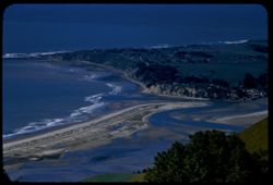
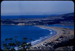
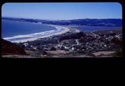
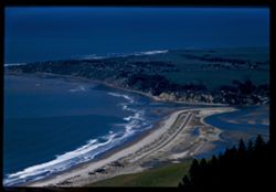
-
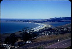
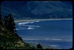
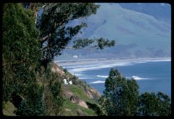
- Description:
- 50 f 9
- Subject:
- Stinson Beach (Calif.), Lakes & ponds, Bolinas Lagoon (Calif.), Roads, Bays (Bodies of water), Shrubs, Trees, Bolinas Bay (Calif.), Seas, Dwellings, and ...
- Series:
- 16-54
- Creator:
- Cushman, Charles W., 1896-1972
- Date Created:
- 1954-10-23
- Genre:
- Landscape photographs
- Frame Number:
- 4
- County:
- Marin
- Abstract:
- The beautiful crescent of Stinson Beach at Bolinas Bay.
- Call Number:
- P07503
- City:
- Bolinas
- Country:
- United States
- State/Province:
- California
- Physical Description:
- Anscochrome film.
- Alternate Identifier:
- 1654.4
- Persistent URL:
- http://purl.dlib.indiana.edu/iudl/archives/cushman/P07503
- Holding Location:
- Bloomington - University Archives
Wells Library E460
1320 E 10th St.
Bloomington, IN 47405
Contact at archives@indiana.edu, 812-855-1127
-
- Description:
- 100 f 8 tl
- Subject:
- Canals, Streets, Hills, Bays (Bodies of water), Trees, Buildings, Angel Island (Calif.), and Islands
- Series:
- 2-56
- Creator:
- Cushman, Charles W., 1896-1972
- Date Created:
- 1956-03-14
- Genre:
- Cityscape photographs
- Frame Number:
- 12
- County:
- Marin
- Abstract:
- Toward Angel Is.
- Call Number:
- P08578
- Country:
- United States
- State/Province:
- California
- Alternate Identifier:
- 256.12
- Persistent URL:
- http://purl.dlib.indiana.edu/iudl/archives/cushman/P08578
- Holding Location:
- Bloomington - University Archives
Wells Library E460
1320 E 10th St.
Bloomington, IN 47405
Contact at archives@indiana.edu, 812-855-1127
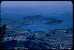
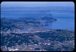
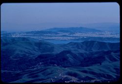
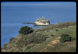
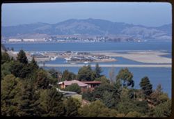
-
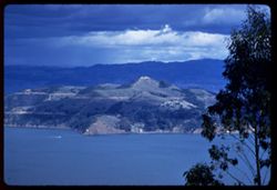
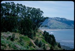
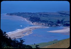
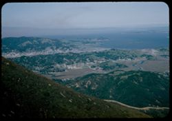
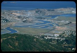
- Description:
- 100 f 6.3 tl
- Subject:
- Sandbars, Hills, Bolinas Lagoon (Calif.), Bays (Bodies of water), Tamalpais, Mount (Calif.), Trees, Coastlines, and Seas
- Series:
- 2-56
- Creator:
- Cushman, Charles W., 1896-1972
- Date Created:
- 1956-03-14
- Genre:
- Landscape photographs
- Frame Number:
- 6
- County:
- Marin
- Abstract:
- Looking down on Bolinas Lagoon
- Call Number:
- P08572
- City:
- Bolinas
- Country:
- United States
- State/Province:
- California
- Alternate Identifier:
- 256.6
- Persistent URL:
- http://purl.dlib.indiana.edu/iudl/archives/cushman/P08572
- Holding Location:
- Bloomington - University Archives
Wells Library E460
1320 E 10th St.
Bloomington, IN 47405
Contact at archives@indiana.edu, 812-855-1127
-

- Description:
- 25 f 6.3 Pola
- Subject:
- Bays (Bodies of water), Shrubs, Trees, Trails & paths, Grasses, and Wildflowers
- Series:
- 12-52
- Creator:
- Cushman, Charles W., 1896-1972
- Date Created:
- 1952-03-30
- Genre:
- Landscape photographs and Cityscape photographs
- Frame Number:
- 14
- Street Address:
- Mount Tamalpais Road
- County:
- Marin
- Abstract:
- View East toward Belvedere - from Mt. Tamalpais Rd. above Mill Valley.
- Call Number:
- P05921
- City:
- Belvedere and Mill Valley
- Country:
- United States
- State/Province:
- California
- Alternate Identifier:
- 1252.14
- Persistent URL:
- http://purl.dlib.indiana.edu/iudl/archives/cushman/P05921
- Holding Location:
- Bloomington - University Archives
Wells Library E460
1320 E 10th St.
Bloomington, IN 47405
Contact at archives@indiana.edu, 812-855-1127
-
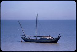
- Description:
- 100 f 5.6 tl
- Subject:
- Junks, San Pablo Bay (Calif.), and Bays (Bodies of water)
- Series:
- 12-56
- Creator:
- Cushman, Charles W., 1896-1972
- Date Created:
- 1956-08-14
- Genre:
- Marine photographs and Seascapes
- Frame Number:
- 17
- County:
- Marin
- Abstract:
- Old junk off shore near china camp
- Call Number:
- P08952
- City:
- China Camp
- Country:
- United States
- State/Province:
- California
- Alternate Identifier:
- 1256.17
- Persistent URL:
- http://purl.dlib.indiana.edu/iudl/archives/cushman/P08952
- Holding Location:
- Bloomington - University Archives
Wells Library E460
1320 E 10th St.
Bloomington, IN 47405
Contact at archives@indiana.edu, 812-855-1127
-
- Description:
- 100 f 6.3 tl
- Subject:
- Cities & towns, Streets, Capes (Coasts), San Pablo Bay (Calif.), Bays (Bodies of water), Point San Pedro (Marin County, Calif.), Tamalpais, Mount (Calif....
- Series:
- 2-56
- Creator:
- Cushman, Charles W., 1896-1972
- Date Created:
- 1956-03-14
- Genre:
- Cityscape photographs
- Frame Number:
- 17
- County:
- Marin
- Abstract:
- Toward Pt. San Pedro
- Call Number:
- P08583
- Country:
- United States
- State/Province:
- California
- Alternate Identifier:
- 256.17
- Persistent URL:
- http://purl.dlib.indiana.edu/iudl/archives/cushman/P08583
- Holding Location:
- Bloomington - University Archives
Wells Library E460
1320 E 10th St.
Bloomington, IN 47405
Contact at archives@indiana.edu, 812-855-1127
-
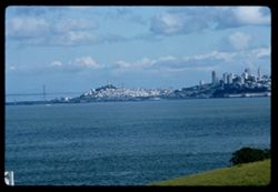
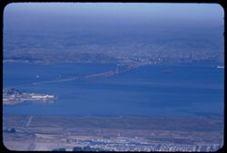
- Description:
- 100 f TL
- Subject:
- Channels, Houses, San Francisco Bay (Calif.), Bridges, Bays (Bodies of water), Waterfronts, Tunnels, Golden Gate Bridge (San Francisco, Calif.), Coastlines, ...
- Series:
- 1-69
- Creator:
- Cushman, Charles W., 1896-1972
- Date Created:
- 1969-02-01
- Genre:
- Landscape photographs
- Frame Number:
- 5
- County:
- Marin and San Francisco
- Call Number:
- P15700
- City:
- San Francisco
- Country:
- United States
- State/Province:
- California
- Alternate Identifier:
- 169.5
- Persistent URL:
- http://purl.dlib.indiana.edu/iudl/archives/cushman/P15700
- Holding Location:
- Bloomington - University Archives
Wells Library E460
1320 E 10th St.
Bloomington, IN 47405
Contact at archives@indiana.edu, 812-855-1127
-
- Description:
- 100 f 8 TL
- Subject:
- Channels, Hills, Bridges, Bays (Bodies of water), Waterfronts, Tunnels, Trees, Golden Gate Bridge (San Francisco, Calif.), Cargo ships, Clouds, and Coastlines
- Series:
- 1-69
- Creator:
- Cushman, Charles W., 1896-1972
- Date Created:
- 1969-02-01
- Genre:
- Marine photographs and Landscape photographs
- Frame Number:
- 10
- County:
- Marin and San Francisco
- Call Number:
- P15705
- City:
- San Francisco
- Country:
- United States
- State/Province:
- California
- Alternate Identifier:
- 169.10
- Persistent URL:
- http://purl.dlib.indiana.edu/iudl/archives/cushman/P15705
- Holding Location:
- Bloomington - University Archives
Wells Library E460
1320 E 10th St.
Bloomington, IN 47405
Contact at archives@indiana.edu, 812-855-1127
-
- Description:
- 100 f 8 TL
- Subject:
- Hills, San Francisco Bay (Calif.), Bridges, Bays (Bodies of water), Trees, Golden Gate Bridge (San Francisco, Calif.), Coastlines, Clouds, and Houses
- Series:
- 1-69
- Creator:
- Cushman, Charles W., 1896-1972
- Date Created:
- 1969-02-01
- Genre:
- Landscape photographs
- Frame Number:
- 1
- County:
- Marin and San Francisco
- Call Number:
- P15696
- City:
- San Francisco
- Country:
- United States
- State/Province:
- California
- Alternate Identifier:
- 169.1
- Persistent URL:
- http://purl.dlib.indiana.edu/iudl/archives/cushman/P15696
- Holding Location:
- Bloomington - University Archives
Wells Library E460
1320 E 10th St.
Bloomington, IN 47405
Contact at archives@indiana.edu, 812-855-1127
-
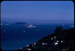
- Description:
- 100 f 8 tl
- Subject:
- Prisons, Roofs, Alcatraz Island (Calif.), San Francisco Bay (Calif.), San Francisco-Oakland Bay Bridge (Oakland and San Francisco, Calif.), Bays (Bodies of w...
- Series:
- 12-56
- Creator:
- Cushman, Charles W., 1896-1972
- Date Created:
- 1956-09-08
- Genre:
- Seascapes and Views
- Frame Number:
- 29
- County:
- Marin and San Francisco
- Abstract:
- Alcatraz from Sausalito
- Call Number:
- P08964
- City:
- San Francisco and Sausalito
- Country:
- United States
- State/Province:
- California
- Alternate Identifier:
- 1256.29
- Persistent URL:
- http://purl.dlib.indiana.edu/iudl/archives/cushman/P08964
- Holding Location:
- Bloomington - University Archives
Wells Library E460
1320 E 10th St.
Bloomington, IN 47405
Contact at archives@indiana.edu, 812-855-1127
-
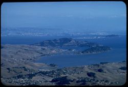
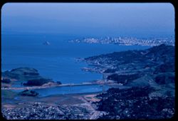
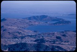
- Description:
- 100 f 6.3 tl
- Subject:
- Cities & towns, Bays (Bodies of water), Tamalpais, Mount (Calif.), Angel Island (Calif.), and Islands
- Series:
- 15-57
- Creator:
- Cushman, Charles W., 1896-1972
- Date Created:
- 1957-10-03
- Genre:
- Cityscape photographs and Views
- Frame Number:
- 32
- County:
- Marin
- Abstract:
- Angel island
- Call Number:
- P09562
- City:
- Belvedere
- Country:
- United States
- State/Province:
- California
- Alternate Identifier:
- 1557.32
- Persistent URL:
- http://purl.dlib.indiana.edu/iudl/archives/cushman/P09562
- Holding Location:
- Bloomington - University Archives
Wells Library E460
1320 E 10th St.
Bloomington, IN 47405
Contact at archives@indiana.edu, 812-855-1127
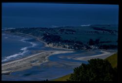
-
- Description:
- 100 f 6.3 tl
- Subject:
- Bays (Bodies of water), Seas, Bolinas Lagoon (Calif.), Trees, Coastlines, Forests, Hills, Sandbars, and Tamalpais, Mount (Calif.)
- Series:
- 2-56
- Creator:
- Cushman, Charles W., 1896-1972
- Date Created:
- 1956-03-14
- Genre:
- Landscape photographs
- Frame Number:
- 5
- County:
- Marin
- Abstract:
- Looking down on Bolinas Lagoon
- Call Number:
- P08571
- City:
- Bolinas
- Country:
- United States
- State/Province:
- California
- Alternate Identifier:
- 256.5
- Persistent URL:
- http://purl.dlib.indiana.edu/iudl/archives/cushman/P08571
- Holding Location:
- Bloomington - University Archives
Wells Library E460
1320 E 10th St.
Bloomington, IN 47405
Contact at archives@indiana.edu, 812-855-1127
-
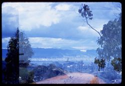
- Description:
- 100 f 6.3 TL
- Subject:
- Bays (Bodies of water), Waldo Height, Boats, Waldo Point Harbor (Calif.), Tree limbs, Mountains, Richardson Bay (Calif.), and Trees
- Series:
- 1-60
- Creator:
- Cushman, Charles W., 1896-1972
- Date Created:
- 1960-02-18
- Genre:
- Cityscape photographs
- Frame Number:
- 28
- County:
- Marin
- Abstract:
- Double exposure
- Call Number:
- P10921
- City:
- Sausalito
- Country:
- United States
- State/Province:
- California
- Alternate Identifier:
- 160.28
- Persistent URL:
- http://purl.dlib.indiana.edu/iudl/archives/cushman/P10921
- Holding Location:
- Bloomington - University Archives
Wells Library E460
1320 E 10th St.
Bloomington, IN 47405
Contact at archives@indiana.edu, 812-855-1127
-
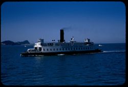
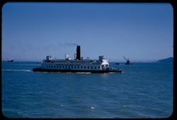
- Description:
- 125 f 5.6
- Subject:
- Bays (Bodies of water), Bodies of water, Boats, Signs (Notices), Ferries, Vehicles, Klamath (Ferry), Russian River (Ferry), Smokestacks, San Francisco Bay (C...
- Series:
- 2-54
- Creator:
- Cushman, Charles W., 1896-1972
- Date Created:
- 1954-05-21
- Genre:
- Marine photographs
- Frame Number:
- 8
- County:
- Marin and Contra Costa
- Abstract:
- Aboard Ferry Boat Russian River from San Rafael to Richmond W bound ferry on port side
- Call Number:
- P07138
- City:
- Richmond and San Rafael
- Country:
- United States
- State/Province:
- California
- Alternate Identifier:
- 254.8
- Persistent URL:
- http://purl.dlib.indiana.edu/iudl/archives/cushman/P07138
- Holding Location:
- Bloomington - University Archives
Wells Library E460
1320 E 10th St.
Bloomington, IN 47405
Contact at archives@indiana.edu, 812-855-1127
-
- Description:
- 108 f 8 TL
- Subject:
- Bays (Bodies of water), Oceans, Cliffs, Trees, Coastlines, Bolinas Bay (Calif.), Beaches, and Hills
- Series:
- 7-56
- Creator:
- Cushman, Charles W., 1896-1972
- Date Created:
- 1956-05-16
- Genre:
- Seascapes
- Frame Number:
- 5
- County:
- Marin
- Abstract:
- Bolinas Bay
- Call Number:
- P08752
- City:
- Bolinas
- Country:
- United States
- State/Province:
- California
- Alternate Identifier:
- 756.5
- Persistent URL:
- http://purl.dlib.indiana.edu/iudl/archives/cushman/P08752
- Holding Location:
- Bloomington - University Archives
Wells Library E460
1320 E 10th St.
Bloomington, IN 47405
Contact at archives@indiana.edu, 812-855-1127
-
- Description:
- 100 f 6.3 TL
- Subject:
- Bays (Bodies of water), Waldo Height, Roads, Angel Island (Calif.), Waldo Point Harbor (Calif.), Mountains, Richardson Bay (Calif.), Clouds, Islands, and Hills
- Series:
- 1-60
- Creator:
- Cushman, Charles W., 1896-1972
- Date Created:
- 1960-02-18
- Genre:
- Landscape photographs
- Frame Number:
- 32
- County:
- Marin
- Abstract:
- Top of Angel Island
- Call Number:
- P10925
- City:
- Sausalito
- Country:
- United States
- State/Province:
- California
- Alternate Identifier:
- 160.32
- Persistent URL:
- http://purl.dlib.indiana.edu/iudl/archives/cushman/P10925
- Holding Location:
- Bloomington - University Archives
Wells Library E460
1320 E 10th St.
Bloomington, IN 47405
Contact at archives@indiana.edu, 812-855-1127
-
- Description:
- 100 f 8 tl
- Subject:
- Bays (Bodies of water), Trees, Cities & towns, Bridges, Tamalpais, Mount (Calif.), Hills, San Francisco Bay (Calif.), and Canals
- Series:
- 2-56
- Creator:
- Cushman, Charles W., 1896-1972
- Date Created:
- 1956-03-14
- Genre:
- Cityscape photographs
- Frame Number:
- 16
- County:
- Marin and San Francisco
- Abstract:
- San Francisco
- Call Number:
- P08582
- City:
- San Francisco
- Country:
- United States
- State/Province:
- California
- Alternate Identifier:
- 256.16
- Persistent URL:
- http://purl.dlib.indiana.edu/iudl/archives/cushman/P08582
- Holding Location:
- Bloomington - University Archives
Wells Library E460
1320 E 10th St.
Bloomington, IN 47405
Contact at archives@indiana.edu, 812-855-1127
-
- Description:
- 100 f 7.8 tl
- Subject:
- Bays (Bodies of water), Seas, Bolinas Lagoon (Calif.), Coastlines, Bolinas Bay (Calif.), Beaches, Tamalpais, Mount (Calif.), and Sandbars
- Series:
- 2-57
- Creator:
- Cushman, Charles W., 1896-1972
- Date Created:
- 1957-03-22
- Genre:
- Landscape photographs and Seascapes
- Frame Number:
- 1
- County:
- Marin
- Abstract:
- Bolinas Bay from Tamalpais
- Call Number:
- P09128
- City:
- Bolinas
- Country:
- United States
- State/Province:
- California
- Alternate Identifier:
- 257.1
- Persistent URL:
- http://purl.dlib.indiana.edu/iudl/archives/cushman/P09128
- Holding Location:
- Bloomington - University Archives
Wells Library E460
1320 E 10th St.
Bloomington, IN 47405
Contact at archives@indiana.edu, 812-855-1127
-
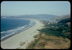
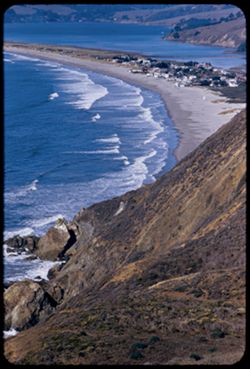
- Description:
- 50 f 8
- Subject:
- Bays (Bodies of water), Seas, Sand, Trees, Coastlines, Bolinas Bay (Calif.), Mountains, Beaches, Shrubs, Lakes & ponds, Dwellings, Stinson Beach (Calif.)...
- Series:
- 4-54
- Creator:
- Cushman, Charles W., 1896-1972
- Date Created:
- 1954-07-29
- Genre:
- Landscape photographs
- Frame Number:
- 11
- County:
- Marin
- Abstract:
- Bolinas Bay from [ct] south
- Call Number:
- P07185
- City:
- Bolinas
- Country:
- United States
- State/Province:
- California
- Physical Description:
- Anscochrome film.
- Alternate Identifier:
- 454.11
- Persistent URL:
- http://purl.dlib.indiana.edu/iudl/archives/cushman/P07185
- Holding Location:
- Bloomington - University Archives
Wells Library E460
1320 E 10th St.
Bloomington, IN 47405
Contact at archives@indiana.edu, 812-855-1127
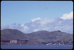
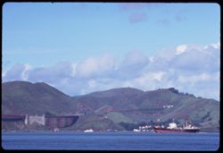
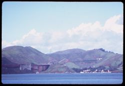
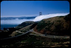
-
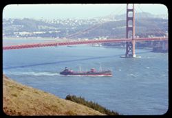
- Description:
- 100 f 8 tl
- Subject:
- Bays (Bodies of water), Fort Barry Military Reservation (Calif.), Golden Gate Bridge (San Francisco, Calif.), Suspension bridges, Cargo ships, Ships, Bridges...
- Series:
- 16-59
- Creator:
- Cushman, Charles W., 1896-1972
- Date Created:
- 1959-09-04
- Genre:
- Landscape photographs, Views, Cityscape photographs, and Architectural photographs
- Frame Number:
- 1
- County:
- Marin and San Francisco
- Abstract:
- Ship outbound
- Call Number:
- P10860
- City:
- San Francisco
- Country:
- United States
- State/Province:
- California
- Physical Description:
- Anscochrome film.
- Alternate Identifier:
- 1659.1
- Persistent URL:
- http://purl.dlib.indiana.edu/iudl/archives/cushman/P10860
- Holding Location:
- Bloomington - University Archives
Wells Library E460
1320 E 10th St.
Bloomington, IN 47405
Contact at archives@indiana.edu, 812-855-1127
-
- Description:
- 100 f 6.3 tl
- Subject:
- Bays (Bodies of water), Trees, Cities & towns, Islands, Tamalpais, Mount (Calif.), Hills, Streams, Canals, and Corte Madera Creek (Marin County, Calif.)
- Series:
- 29-55
- Creator:
- Cushman, Charles W., 1896-1972
- Date Created:
- 1955-10-31
- Genre:
- Landscape photographs and Cityscape photographs
- Frame Number:
- 8
- County:
- Marin
- Abstract:
- Canals (?)
- Call Number:
- P08499
- Country:
- United States
- State/Province:
- California
- Alternate Identifier:
- 2955.8
- Persistent URL:
- http://purl.dlib.indiana.edu/iudl/archives/cushman/P08499
- Holding Location:
- Bloomington - University Archives
Wells Library E460
1320 E 10th St.
Bloomington, IN 47405
Contact at archives@indiana.edu, 812-855-1127
-
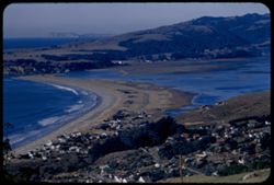
- Description:
- 100 f 8 tl
- Subject:
- Bays (Bodies of water), Oceans, Stinson Beach (Calif.), Cliffs, Sandbars, Coastlines, Pacific Ocean, Cities & towns, Buildings, Pacific Coast (Calif.), W...
- Series:
- 16-56
- Creator:
- Cushman, Charles W., 1896-1972
- Date Created:
- 1956-12-07
- Genre:
- Seascapes and Views
- Frame Number:
- 2
- Street Address:
- Panoramic Highway
- County:
- Marin
- Abstract:
- Curve of Bolinas Bay - from Panoramic Hwy.
- Call Number:
- P09070
- Country:
- United States
- State/Province:
- California
- Alternate Identifier:
- 1656.2
- Persistent URL:
- http://purl.dlib.indiana.edu/iudl/archives/cushman/P09070
- Holding Location:
- Bloomington - University Archives
Wells Library E460
1320 E 10th St.
Bloomington, IN 47405
Contact at archives@indiana.edu, 812-855-1127
-
- Description:
- 100 f 8 tl
- Subject:
- Bays (Bodies of water), Trees, San Francisco-Oakland Bay Bridge (Oakland and San Francisco, Calif.), Telegraph Hill (San Francisco, Calif.), Buildings, Coit ...
- Series:
- 12-56
- Creator:
- Cushman, Charles W., 1896-1972
- Date Created:
- 1956-09-08
- Genre:
- Views and Cityscape photographs
- Frame Number:
- 28
- County:
- Marin and San Francisco
- Abstract:
- SF from Sausalito
- Call Number:
- P08963
- City:
- Sausalito and San Francisco
- Country:
- United States
- State/Province:
- California
- Alternate Identifier:
- 1256.28
- Persistent URL:
- http://purl.dlib.indiana.edu/iudl/archives/cushman/P08963
- Holding Location:
- Bloomington - University Archives
Wells Library E460
1320 E 10th St.
Bloomington, IN 47405
Contact at archives@indiana.edu, 812-855-1127
-
- Description:
- 100 f 5.6 tl
- Subject:
- Bays (Bodies of water), Richmond-San Rafael Bridge, Bridge construction, Cities & towns, Buildings, Bridges, Islands, Tamalpais, Mount (Calif.), Hills, a...
- Series:
- 29-55
- Creator:
- Cushman, Charles W., 1896-1972
- Date Created:
- 1955-10-31
- Genre:
- Landscape photographs and Cityscape photographs
- Frame Number:
- 13
- County:
- Marin
- Abstract:
- New bridge - SR to Richmond again
- Call Number:
- P08504
- Country:
- United States
- State/Province:
- California
- Alternate Identifier:
- 2955.13
- Persistent URL:
- http://purl.dlib.indiana.edu/iudl/archives/cushman/P08504
- Holding Location:
- Bloomington - University Archives
Wells Library E460
1320 E 10th St.
Bloomington, IN 47405
Contact at archives@indiana.edu, 812-855-1127
-
- Description:
- 100 f 5.6 tl
- Subject:
- Bays (Bodies of water), Angel Island (Calif.), Trees, Mountains, Islands, Tamalpais, Mount (Calif.), Hills, and Cities & towns
- Series:
- 29-55
- Creator:
- Cushman, Charles W., 1896-1972
- Date Created:
- 1955-10-31
- Genre:
- Landscape photographs and Cityscape photographs
- Frame Number:
- 12
- County:
- Marin
- Abstract:
- Toward Angel Island & Belvidere
- Call Number:
- P08503
- City:
- Belvedere
- Country:
- United States
- State/Province:
- California
- Alternate Identifier:
- 2955.12
- Persistent URL:
- http://purl.dlib.indiana.edu/iudl/archives/cushman/P08503
- Holding Location:
- Bloomington - University Archives
Wells Library E460
1320 E 10th St.
Bloomington, IN 47405
Contact at archives@indiana.edu, 812-855-1127
-
- Description:
- 100 f 8 tl
- Subject:
- Bays (Bodies of water), Skyscrapers, Cities & towns, Buildings, Bridges, Tamalpais, Mount (Calif.), Hills, San Francisco Bay (Calif.), Canals, and Trees
- Series:
- 2-56
- Creator:
- Cushman, Charles W., 1896-1972
- Date Created:
- 1956-03-14
- Genre:
- Cityscape photographs
- Frame Number:
- 11
- County:
- Marin and San Francisco
- Abstract:
- City of San Francisco
- Call Number:
- P08577
- City:
- San Francisco
- Country:
- United States
- State/Province:
- California
- Alternate Identifier:
- 256.11
- Persistent URL:
- http://purl.dlib.indiana.edu/iudl/archives/cushman/P08577
- Holding Location:
- Bloomington - University Archives
Wells Library E460
1320 E 10th St.
Bloomington, IN 47405
Contact at archives@indiana.edu, 812-855-1127
-
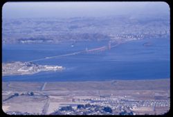
- Description:
- 100 f 8 tl
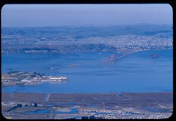
- Subject:
- Bays (Bodies of water), Richmond-San Rafael Bridge, Cities & towns, Bridges, Tamalpais, Mount (Calif.), Hills, and Canals
- Series:
- 2-56
- Creator:
- Cushman, Charles W., 1896-1972
- Date Created:
- 1956-03-14
- Genre:
- Landscape photographs and Cityscape photographs
- Frame Number:
- 18
- County:
- Marin and Contra Costa
- Abstract:
- San Rafael - Richm'd Bridge
- Call Number:
- P08584
- City:
- San Quentin, Richmond, and San Rafael
- Country:
- United States
- State/Province:
- California
- Alternate Identifier:
- 256.18
- Persistent URL:
- http://purl.dlib.indiana.edu/iudl/archives/cushman/P08584
- Holding Location:
- Bloomington - University Archives
Wells Library E460
1320 E 10th St.
Bloomington, IN 47405
Contact at archives@indiana.edu, 812-855-1127
-
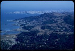
- Description:
- 25 f 6 Pola
- Subject:
- Bays (Bodies of water), Oceans, Coastlines, Pacific Ocean, Shrubs, Pacific Coast (Calif.), Tamalpais, Mount (Calif.), Hills, and San Francisco Bay (Calif.)
- Series:
- 12-52
- Creator:
- Cushman, Charles W., 1896-1972
- Date Created:
- 1952-03-30
- Genre:
- Landscape photographs and Cityscape photographs
- Frame Number:
- 17
- County:
- Marin and San Francisco
- Abstract:
- SF beyond Marin hills.
- Call Number:
- P05924
- City:
- San Francisco
- Country:
- United States
- State/Province:
- California
- Alternate Identifier:
- 1252.17
- Persistent URL:
- http://purl.dlib.indiana.edu/iudl/archives/cushman/P05924
- Holding Location:
- Bloomington - University Archives
Wells Library E460
1320 E 10th St.
Bloomington, IN 47405
Contact at archives@indiana.edu, 812-855-1127
-
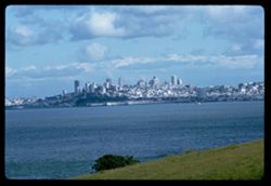
- Description:
- 100 f 8 tl
- Subject:
- Bays (Bodies of water), Trees, San Francisco-Oakland Bay Bridge (Oakland and San Francisco, Calif.), Roofs, Telegraph Hill (San Francisco, Calif.), Buildings...
- Series:
- 12-56
- Creator:
- Cushman, Charles W., 1896-1972
- Date Created:
- 1956-09-08
- Genre:
- Cityscape photographs
- Frame Number:
- 32
- County:
- Marin and San Francisco
- Abstract:
- SF from hts of Sausalito
- Call Number:
- P08967
- City:
- Sausalito and San Francisco
- Country:
- United States
- State/Province:
- California
- Alternate Identifier:
- 1256.32
- Persistent URL:
- http://purl.dlib.indiana.edu/iudl/archives/cushman/P08967
- Holding Location:
- Bloomington - University Archives
Wells Library E460
1320 E 10th St.
Bloomington, IN 47405
Contact at archives@indiana.edu, 812-855-1127
-
- Description:
- 100 f 5.6 tl
- Subject:
- Bays (Bodies of water), Bodies of water, Trees, and Birds
- Series:
- 5-55
- Creator:
- Cushman, Charles W., 1896-1972
- Date Created:
- 1955-03-10
- Genre:
- Views
- Frame Number:
- 15
- County:
- Marin
- Abstract:
- From Belvedere - birds on water of bay
- Call Number:
- P07680
- City:
- Belvedere
- Country:
- United States
- State/Province:
- California
- Alternate Identifier:
- 555.15
- Persistent URL:
- http://purl.dlib.indiana.edu/iudl/archives/cushman/P07680
- Holding Location:
- Bloomington - University Archives
Wells Library E460
1320 E 10th St.
Bloomington, IN 47405
Contact at archives@indiana.edu, 812-855-1127
-
- Description:
- 100 f 6.3 tl
- Subject:
- Bays (Bodies of water), Richmond-San Rafael Bridge, Bridge construction, Cities & towns, Bridges, Tamalpais, Mount (Calif.), and Hills
- Series:
- 29-55
- Creator:
- Cushman, Charles W., 1896-1972
- Date Created:
- 1955-10-31
- Genre:
- Cityscape photographs
- Frame Number:
- 7
- County:
- Marin
- Abstract:
- San Rafael - Richmond bridge under construction
- Call Number:
- P08498
- Country:
- United States
- State/Province:
- California
- Alternate Identifier:
- 2955.7
- Persistent URL:
- http://purl.dlib.indiana.edu/iudl/archives/cushman/P08498
- Holding Location:
- Bloomington - University Archives
Wells Library E460
1320 E 10th St.
Bloomington, IN 47405
Contact at archives@indiana.edu, 812-855-1127
-
- Description:
- 100 f 4 TL
- Subject:
- Bays (Bodies of water), Vessels, Golden Gate Bridge (San Francisco, Calif.), Suspension bridges, Coastlines, Clouds, Hills, San Francisco Bay (Calif.), and C...
- Series:
- 1-69
- Creator:
- Cushman, Charles W., 1896-1972
- Date Created:
- 1969-02-01
- Genre:
- Landscape photographs and Marine photographs
- Frame Number:
- 3
- County:
- Marin and San Francisco
- Call Number:
- P15698
- City:
- San Francisco
- Country:
- United States
- State/Province:
- California
- Alternate Identifier:
- 169.3
- Persistent URL:
- http://purl.dlib.indiana.edu/iudl/archives/cushman/P15698
- Holding Location:
- Bloomington - University Archives
Wells Library E460
1320 E 10th St.
Bloomington, IN 47405
Contact at archives@indiana.edu, 812-855-1127
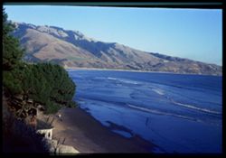
-
- Description:
- 100 f 8 tl
- Subject:
- Bays (Bodies of water), Oceans, Seas, Cliffs, Trees, Coastlines, Bolinas Bay (Calif.), Tree limbs, Mountains, Beaches, Hills, and People
- Series:
- 1-68
- Creator:
- Cushman, Charles W., 1896-1972
- Date Created:
- 1968-03-02
- Genre:
- Landscape photographs and Seascapes
- Frame Number:
- 18
- County:
- Marin
- Abstract:
- at Bolinas
- Call Number:
- P15613
- City:
- Bolinas
- Country:
- United States
- State/Province:
- California
- Alternate Identifier:
- 168.18
- Persistent URL:
- http://purl.dlib.indiana.edu/iudl/archives/cushman/P15613
- Holding Location:
- Bloomington - University Archives
Wells Library E460
1320 E 10th St.
Bloomington, IN 47405
Contact at archives@indiana.edu, 812-855-1127
-
- Description:
- 100 f 8 tl
- Subject:
- Bays (Bodies of water), Oceans, Seas, Cliffs, Trees, Coastlines, Bolinas Bay (Calif.), Tree limbs, Mountains, Beaches, Hills, and People
- Series:
- 1-68
- Creator:
- Cushman, Charles W., 1896-1972
- Date Created:
- 1968-03-02
- Genre:
- Landscape photographs and Seascapes
- Frame Number:
- 16
- County:
- Marin
- Abstract:
- at Bolinas
- Call Number:
- P15611
- City:
- Bolinas
- Country:
- United States
- State/Province:
- California
- Alternate Identifier:
- 168.16
- Persistent URL:
- http://purl.dlib.indiana.edu/iudl/archives/cushman/P15611
- Holding Location:
- Bloomington - University Archives
Wells Library E460
1320 E 10th St.
Bloomington, IN 47405
Contact at archives@indiana.edu, 812-855-1127
-
- Description:
- 100 f 8
- Subject:
- Bays (Bodies of water), Grasses, Cliffs, Trees, Coastlines, Bolinas Bay (Calif.), Mountains, Beaches, Shrubs, and Hills
- Series:
- 1-68
- Creator:
- Cushman, Charles W., 1896-1972
- Date Created:
- 1968-03-20
- Genre:
- Landscape photographs and Seascapes
- Frame Number:
- 29
- County:
- Marin
- Abstract:
- Across Bolinas Bay
- Call Number:
- P15623
- City:
- Bolinas
- Country:
- United States
- State/Province:
- California
- Alternate Identifier:
- 168.29
- Persistent URL:
- http://purl.dlib.indiana.edu/iudl/archives/cushman/P15623
- Holding Location:
- Bloomington - University Archives
Wells Library E460
1320 E 10th St.
Bloomington, IN 47405
Contact at archives@indiana.edu, 812-855-1127
-
- Description:
- 50 f 8
- Subject:
- Wildflowers, Bays (Bodies of water), Richardson Bay Bridge (Calif.), Grasses, Trees, Mountains, Richardson Bay (Calif.), Shrubs, Tamalpais, Mount (Calif.), H...
- Series:
- 4-54
- Creator:
- Cushman, Charles W., 1896-1972
- Date Created:
- 1954-08-13
- Genre:
- Cityscape photographs
- Frame Number:
- 14
- Street Address:
- United States Highway 101
- County:
- Marin
- Abstract:
- Mt. Tamalpais from US101- Richardson Bay bridge
- Call Number:
- P07188
- Country:
- United States
- State/Province:
- California
- Physical Description:
- Anscochrome film.
- Alternate Identifier:
- 454.14
- Persistent URL:
- http://purl.dlib.indiana.edu/iudl/archives/cushman/P07188
- Holding Location:
- Bloomington - University Archives
Wells Library E460
1320 E 10th St.
Bloomington, IN 47405
Contact at archives@indiana.edu, 812-855-1127
-
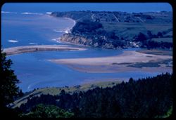
- Description:
- 100 f 6.3 tl
- Subject:
- Bays (Bodies of water), Oceans, Stinson Beach (Calif.), Sandbars, Coastlines, Bolinas Bay (Calif.), Cities & towns, Beaches, Pacific Coast (Calif.), Wate...
- Series:
- 16-56
- Creator:
- Cushman, Charles W., 1896-1972
- Date Created:
- 1956-12-07
- Genre:
- Landscape photographs, Seascapes, and Views
- Frame Number:
- 3
- Street Address:
- Panoramic Highway
- County:
- Marin
- Abstract:
- Spit & lagoon - from Panoramic Hwy
- Call Number:
- P09071
- Country:
- United States
- State/Province:
- California
- Alternate Identifier:
- 1656.3
- Persistent URL:
- http://purl.dlib.indiana.edu/iudl/archives/cushman/P09071
- Holding Location:
- Bloomington - University Archives
Wells Library E460
1320 E 10th St.
Bloomington, IN 47405
Contact at archives@indiana.edu, 812-855-1127
-
- Description:
- 100 f 7 tl
- Subject:
- Bays (Bodies of water), Seas, Sandbars, Trees, Coastlines, Peninsulas, Tamalpais, Mount (Calif.), and Hills
- Series:
- 2-56
- Creator:
- Cushman, Charles W., 1896-1972
- Date Created:
- 1956-03-14
- Genre:
- Landscape photographs
- Frame Number:
- 10
- County:
- Marin
- Abstract:
- Down on Bolinas noon
- Call Number:
- P08576
- City:
- Bolinas
- Country:
- United States
- State/Province:
- California
- Alternate Identifier:
- 256.10
- Persistent URL:
- http://purl.dlib.indiana.edu/iudl/archives/cushman/P08576
- Holding Location:
- Bloomington - University Archives
Wells Library E460
1320 E 10th St.
Bloomington, IN 47405
Contact at archives@indiana.edu, 812-855-1127
-
- Description:
- 25 f 8 Pola
- Subject:
- Bays (Bodies of water), Grasses, Houses, Fog, Flowers, Roofs, Shrubs, Clouds, Tomales Bay (Calif.), Bleu Baie Tavern (Marshall, Calif.), and Pacific Coast Hi...
- Series:
- 7-53
- Creator:
- Cushman, Charles W., 1896-1972
- Date Created:
- 1953-07-08
- Genre:
- Views
- Frame Number:
- 26
- Street Address:
- California State Highway 1
- County:
- Marin
- Abstract:
- Tomales Bay from cove at Bleu Baie Tavern 3 mi. north of Marshall on Calif. 1.
- Call Number:
- P06751
- City:
- Marshall
- Country:
- United States
- State/Province:
- California
- Alternate Identifier:
- 753.26
- Persistent URL:
- http://purl.dlib.indiana.edu/iudl/archives/cushman/P06751
- Holding Location:
- Bloomington - University Archives
Wells Library E460
1320 E 10th St.
Bloomington, IN 47405
Contact at archives@indiana.edu, 812-855-1127
-
- Description:
- 100 f 6.3 tl
- Subject:
- Bays (Bodies of water), Richmond-San Rafael Bridge (Calif.), Mountains, Bridges, Tamalpais, Mount (Calif.), San Francisco Bay (Calif.), and Cities & towns
- Series:
- 15-57
- Creator:
- Cushman, Charles W., 1896-1972
- Date Created:
- 1957-10-03
- Genre:
- Views and Cityscape photographs
- Frame Number:
- 31
- County:
- Marin
- Abstract:
- Richmond - San Rafael Bridge
- Call Number:
- P09561
- Country:
- United States
- State/Province:
- California
- Alternate Identifier:
- 1557.31
- Persistent URL:
- http://purl.dlib.indiana.edu/iudl/archives/cushman/P09561
- Holding Location:
- Bloomington - University Archives
Wells Library E460
1320 E 10th St.
Bloomington, IN 47405
Contact at archives@indiana.edu, 812-855-1127
-
- Description:
- 50mm f 8 sl
- Subject:
- Bays (Bodies of water), Seas, Bolinas Lagoon (Calif.), Trees, Coastlines, Bolinas Bay (Calif.), Peninsulas, Hills, and Sandbars
- Series:
- 2-56
- Creator:
- Cushman, Charles W., 1896-1972
- Date Created:
- 1956-03-14
- Genre:
- Landscape photographs
- Frame Number:
- 8
- County:
- Marin
- Abstract:
- Bolinas lagoon - noon
- Call Number:
- P08574
- City:
- Bolinas
- Country:
- United States
- State/Province:
- California
- Alternate Identifier:
- 256.8
- Persistent URL:
- http://purl.dlib.indiana.edu/iudl/archives/cushman/P08574
- Holding Location:
- Bloomington - University Archives
Wells Library E460
1320 E 10th St.
Bloomington, IN 47405
Contact at archives@indiana.edu, 812-855-1127
-
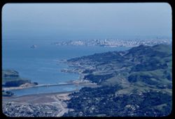
- Description:
- 100 f 8 tl
- Subject:
- Bays (Bodies of water), San Bruno Mountain (Calif.), Roads, Trees, Cities & towns, Tamalpais, Mount (Calif.), Hills, and Mountains
- Series:
- 2-56
- Creator:
- Cushman, Charles W., 1896-1972
- Date Created:
- 1956-03-14
- Genre:
- Landscape photographs and Cityscape photographs
- Frame Number:
- 13
- County:
- Marin and San Francisco
- Abstract:
- Toward Mt. San Bruno
- Call Number:
- P08579
- City:
- San Francisco
- Country:
- United States
- State/Province:
- California
- Alternate Identifier:
- 256.13
- Persistent URL:
- http://purl.dlib.indiana.edu/iudl/archives/cushman/P08579
- Holding Location:
- Bloomington - University Archives
Wells Library E460
1320 E 10th St.
Bloomington, IN 47405
Contact at archives@indiana.edu, 812-855-1127
-
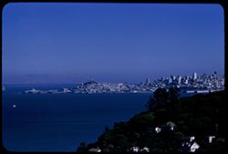
- Description:
- 100 f 9 TL
- Subject:
- Bays (Bodies of water), Piers & wharves, Grasses, Skyscrapers, Coastlines, Clouds, Hills, and San Francisco Bay (Calif.)
- Series:
- 1-63
- Creator:
- Cushman, Charles W., 1896-1972
- Date Created:
- 1963-04-09
- Genre:
- Cityscape photographs
- Frame Number:
- 17
- County:
- Marin and San Francisco
- Abstract:
- S.F. from Marin
- Call Number:
- P12821
- City:
- San Francisco
- Country:
- United States
- State/Province:
- California
- Alternate Identifier:
- 163.17
- Persistent URL:
- http://purl.dlib.indiana.edu/iudl/archives/cushman/P12821
- Holding Location:
- Bloomington - University Archives
Wells Library E460
1320 E 10th St.
Bloomington, IN 47405
Contact at archives@indiana.edu, 812-855-1127
-
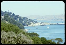
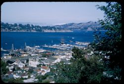
- Description:
- 100 f 8 tl
- Subject:
- Bays (Bodies of water), Piers & wharves, Trees, Buildings, Hills, Boats, and Richardson Bay (Calif.)
- Series:
- 15-59
- Creator:
- Cushman, Charles W., 1896-1972
- Date Created:
- 1959-08-25
- Genre:
- Landscape photographs, Marine photographs, Views, and Cityscape photographs
- Frame Number:
- 18
- County:
- Marin
- Abstract:
- Suasalito from up Richardson Bay
- Call Number:
- P10857
- City:
- Sausalito
- Country:
- United States
- State/Province:
- California
- Physical Description:
- Anscochrome film.
- Alternate Identifier:
- 1559.18
- Persistent URL:
- http://purl.dlib.indiana.edu/iudl/archives/cushman/P10857
- Holding Location:
- Bloomington - University Archives
Wells Library E460
1320 E 10th St.
Bloomington, IN 47405
Contact at archives@indiana.edu, 812-855-1127
-
- Subject:
- Bays (Bodies of water), Vessels, Angel Island (Calif.), Trees, Streets, Richardson Bay (Calif.), Shrubs, Islands, Dwellings, and Hills
- Series:
- 8-40
- Creator:
- Cushman, Charles W., 1896-1972
- Date Created:
- 1940-07-01
- Genre:
- Landscape photographs
- Frame Number:
- 19
- County:
- Marin
- Abstract:
- East across Richardson Bay.
- Call Number:
- P01902
- City:
- Sausalito and Belvedere
- Country:
- United States
- State/Province:
- California
- Physical Description:
- Image was originally mounted in a glass enclosure. Before digitization, the image was removed and placed in a Wess Plastic, Inc. brand, 2" x 2", pl...
- Alternate Identifier:
- 840.19
- Persistent URL:
- http://purl.dlib.indiana.edu/iudl/archives/cushman/P01902
- Holding Location:
- Bloomington - University Archives
Wells Library E460
1320 E 10th St.
Bloomington, IN 47405
Contact at archives@indiana.edu, 812-855-1127
-
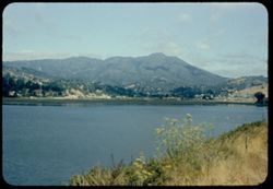
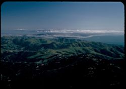
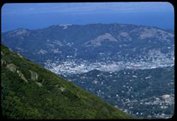
- Description:
- 25 f 8 Pola
- Subject:
- Bays (Bodies of water), Roads, Mountains, Tamalpais, Mount (Calif.), Hills, and San Francisco Bay (Calif.)
- Series:
- 12-52
- Creator:
- Cushman, Charles W., 1896-1972
- Date Created:
- 1952-03-30
- Genre:
- Landscape photographs and Cityscape photographs
- Frame Number:
- 23
- County:
- Marin
- Abstract:
- View N by E over San Rafael.
- Call Number:
- P05930
- City:
- San Rafael
- Country:
- United States
- State/Province:
- California
- Alternate Identifier:
- 1252.23
- Persistent URL:
- http://purl.dlib.indiana.edu/iudl/archives/cushman/P05930
- Holding Location:
- Bloomington - University Archives
Wells Library E460
1320 E 10th St.
Bloomington, IN 47405
Contact at archives@indiana.edu, 812-855-1127
-
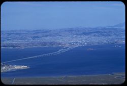
- Description:
- 100 f 11 ft
- Subject:
- Towers, Bays (Bodies of water), Grasses, Suspension bridges, Skyscrapers, Coastlines, San Francisco-Oakland Bay Bridge (Oakland and San Francisco, Calif.), T...
- Series:
- 1-63
- Creator:
- Cushman, Charles W., 1896-1972
- Date Created:
- 1963-04-09
- Genre:
- Cityscape photographs
- Frame Number:
- 16
- County:
- Marin and San Francisco
- Abstract:
- S.F. from Marin
- Call Number:
- P12820
- City:
- San Francisco
- Country:
- United States
- State/Province:
- California
- Alternate Identifier:
- 163.16
- Persistent URL:
- http://purl.dlib.indiana.edu/iudl/archives/cushman/P12820
- Holding Location:
- Bloomington - University Archives
Wells Library E460
1320 E 10th St.
Bloomington, IN 47405
Contact at archives@indiana.edu, 812-855-1127
-
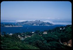
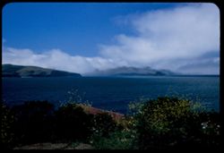
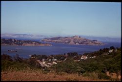
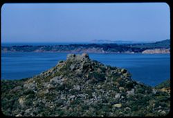
- Description:
- 25 f 6.3 Pola
- Subject:
- Bays (Bodies of water), Roads, Angel Island (Calif.), Fog, Trees, Mountains, Islands, Hills, North Bay (Humboldt County, Calif.), San Francisco Bay (Calif.),...
- Series:
- 8-53
- Creator:
- Cushman, Charles W., 1896-1972
- Date Created:
- 1953-08-30
- Genre:
- Landscape photographs
- Frame Number:
- 8
- County:
- Marin
- Abstract:
- Looking down on Angel Island from heights above Sausalito with fog over North Bay.
- Call Number:
- P06770
- City:
- Sausalito
- Country:
- United States
- State/Province:
- California
- Alternate Identifier:
- 853.8
- Persistent URL:
- http://purl.dlib.indiana.edu/iudl/archives/cushman/P06770
- Holding Location:
- Bloomington - University Archives
Wells Library E460
1320 E 10th St.
Bloomington, IN 47405
Contact at archives@indiana.edu, 812-855-1127
-
- Description:
- 25 f 6.3 Pola
- Subject:
- Bays (Bodies of water), Oceans, Fog, Trees, Coastlines, Pacific Ocean, Pacific Coast (Calif.), Tamalpais, Mount (Calif.), Hills, San Francisco Bay (Calif.), ...
- Series:
- 12-52
- Creator:
- Cushman, Charles W., 1896-1972
- Date Created:
- 1952-03-30
- Genre:
- Landscape photographs and Cityscape photographs
- Frame Number:
- 18
- County:
- Marin and San Francisco
- Abstract:
- Fog bank over SF.
- Call Number:
- P05925
- City:
- San Francisco
- Country:
- United States
- State/Province:
- California
- Alternate Identifier:
- 1252.18
- Persistent URL:
- http://purl.dlib.indiana.edu/iudl/archives/cushman/P05925
- Holding Location:
- Bloomington - University Archives
Wells Library E460
1320 E 10th St.
Bloomington, IN 47405
Contact at archives@indiana.edu, 812-855-1127
-
- Description:
- 100 f 5.6
- Subject:
- Bays (Bodies of water), Seas, Bolinas Lagoon (Calif.), Automobiles, Trees, Bolinas Bay (Calif.), Streets, Beaches, Shrubs, Lakes & ponds, Dwellings, Hill...
- Series:
- 16-54
- Creator:
- Cushman, Charles W., 1896-1972
- Date Created:
- 1954-10-23
- Genre:
- Landscape photographs
- Frame Number:
- 5
- County:
- Marin
- Abstract:
- The beautiful crescent of Stinson Beach at Bolinas Bay from lower + closer.
- Call Number:
- P07504
- City:
- Bolinas
- Country:
- United States
- State/Province:
- California
- Physical Description:
- Anscochrome film, mask.
- Alternate Identifier:
- 1654.5
- Persistent URL:
- http://purl.dlib.indiana.edu/iudl/archives/cushman/P07504
- Holding Location:
- Bloomington - University Archives
Wells Library E460
1320 E 10th St.
Bloomington, IN 47405
Contact at archives@indiana.edu, 812-855-1127
-
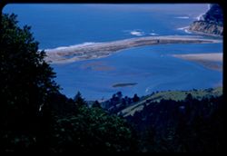
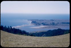
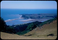
- Description:
- 100 f 6.3 tl
- Subject:
- Bays (Bodies of water), Seas, Bolinas Lagoon (Calif.), Coastlines, Bolinas Bay (Calif.), Cities & towns, Land, Firs, Sandbars, and Forests
- Series:
- 29-55
- Creator:
- Cushman, Charles W., 1896-1972
- Date Created:
- 1955-11-06
- Genre:
- Landscape photographs
- Frame Number:
- 17
- Street Address:
- Ridgecrest Road
- County:
- Marin
- Abstract:
- Bolinas Bar
- Call Number:
- P08508
- City:
- Bolinas
- Country:
- United States
- State/Province:
- California
- Alternate Identifier:
- 2955.17
- Persistent URL:
- http://purl.dlib.indiana.edu/iudl/archives/cushman/P08508
- Holding Location:
- Bloomington - University Archives
Wells Library E460
1320 E 10th St.
Bloomington, IN 47405
Contact at archives@indiana.edu, 812-855-1127
-
- Description:
- 100 f 8 tl
- Subject:
- Bays (Bodies of water), Seas, Sandbars, Coastlines, Bolinas Bay (Calif.), Beaches, Tamalpais, Mount (Calif.), and Bolinas Lagoon (Calif.)
- Series:
- 2-57
- Creator:
- Cushman, Charles W., 1896-1972
- Date Created:
- 1957-03-22
- Genre:
- Landscape photographs and Seascapes
- Frame Number:
- 3
- County:
- Marin
- Abstract:
- Tamalpais looking down on Bolinas
- Call Number:
- P09129
- City:
- Bolinas
- Country:
- United States
- State/Province:
- California
- Physical Description:
- Image was originally mounted in a glass enclosure. Before digitization, the image was removed and placed in a Wess Plastic, Inc. brand, 2" x 2", pl...
- Alternate Identifier:
- 257.3
- Persistent URL:
- http://purl.dlib.indiana.edu/iudl/archives/cushman/P09129
- Holding Location:
- Bloomington - University Archives
Wells Library E460
1320 E 10th St.
Bloomington, IN 47405
Contact at archives@indiana.edu, 812-855-1127
-
- Description:
- 50 f 8
- Subject:
- Bays (Bodies of water), Oceans, Seas, Trees, Coastlines, Bolinas Bay (Calif.), Beaches, Shrubs, Dwellings, and Hills
- Series:
- 16-54
- Creator:
- Cushman, Charles W., 1896-1972
- Date Created:
- 1954-10-23
- Genre:
- Landscape photographs
- Frame Number:
- 7
- County:
- Marin
- Abstract:
- East across Bolinas Bay with breakers.
- Call Number:
- P07506
- Country:
- United States
- State/Province:
- California
- Physical Description:
- Anscochrome film. Image was originally mounted in a glass enclosure. Before digitization, the image was removed and placed in a Wess Plastic, Inc. brand, 2&q...
- Alternate Identifier:
- 1654.7
- Persistent URL:
- http://purl.dlib.indiana.edu/iudl/archives/cushman/P07506
- Holding Location:
- Bloomington - University Archives
Wells Library E460
1320 E 10th St.
Bloomington, IN 47405
Contact at archives@indiana.edu, 812-855-1127
-
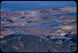
- Description:
- 100 f 6.3 tl
- Subject:
- Bays (Bodies of water), San Pablo Bay (Calif.), Grasses, Cliffs, Shrubs, and Islands
- Series:
- 27-60
- Creator:
- Cushman, Charles W., 1896-1972
- Date Created:
- 1961-01-31
- Genre:
- Landscape photographs and Seascapes
- Frame Number:
- 16
- County:
- Marin
- Abstract:
- San Pablo Bay- Islet near China Camp
- Call Number:
- P11758
- City:
- China Camp
- Country:
- United States
- State/Province:
- California
- Alternate Identifier:
- 2760.16
- Persistent URL:
- http://purl.dlib.indiana.edu/iudl/archives/cushman/P11758
- Holding Location:
- Bloomington - University Archives
Wells Library E460
1320 E 10th St.
Bloomington, IN 47405
Contact at archives@indiana.edu, 812-855-1127
-
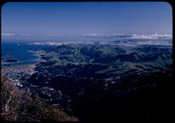
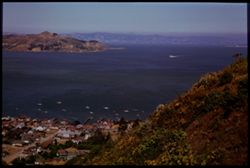
- Description:
- 100 f 6.3 tl
- Subject:
- Bays (Bodies of water), Mountains, Bridges, Tamalpais, Mount (Calif.), Hills, San Francisco Bay (Calif.), and Cities & towns
- Series:
- 15-57
- Creator:
- Cushman, Charles W., 1896-1972
- Date Created:
- 1957-10-03
- Genre:
- Cityscape photographs
- Frame Number:
- 33
- County:
- Marin and San Francisco
- Abstract:
- Marin hills above Sausalito from Tam.
- Call Number:
- P09563
- City:
- Sausalito and San Francisco
- Country:
- United States
- State/Province:
- California
- Alternate Identifier:
- 1557.33
- Persistent URL:
- http://purl.dlib.indiana.edu/iudl/archives/cushman/P09563
- Holding Location:
- Bloomington - University Archives
Wells Library E460
1320 E 10th St.
Bloomington, IN 47405
Contact at archives@indiana.edu, 812-855-1127
-
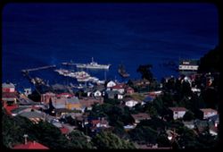
- Description:
- 100 f 6.3 tl
- Subject:
- Bays (Bodies of water), Piers & wharves, Electric lines, Cities & towns, Buildings, Waterfronts, Raccoon Strait (Calif.), and Utility poles
- Series:
- 1-60
- Creator:
- Cushman, Charles W., 1896-1972
- Date Created:
- 1960-02-02
- Genre:
- Cityscape photographs
- Frame Number:
- 8
- County:
- Marin
- Abstract:
- N. shore of Raccoon Strt.
- Call Number:
- P10902
- City:
- Tiburon
- Country:
- United States
- State/Province:
- California
- Alternate Identifier:
- 160.8
- Persistent URL:
- http://purl.dlib.indiana.edu/iudl/archives/cushman/P10902
- Holding Location:
- Bloomington - University Archives
Wells Library E460
1320 E 10th St.
Bloomington, IN 47405
Contact at archives@indiana.edu, 812-855-1127
-
- Subject:
- East Bay Hills (Calif.), Vessels, Islands, Mountains, Angel Island (Calif.), Trees, Dwellings, Bays (Bodies of water), San Francisco Bay (Calif.), Streets, A...
- Series:
- 8-40
- Creator:
- Cushman, Charles W., 1896-1972
- Date Created:
- 1940-07-01
- Genre:
- Views
- Frame Number:
- 17
- County:
- Marin and San Francisco
- Abstract:
- Sausolito, Angel Island, and East Bay Hills.
- Call Number:
- P01900
- City:
- San Francisco and Sausalito
- Country:
- United States
- State/Province:
- California
- Physical Description:
- Image was originally mounted in a glass enclosure. Before digitization, the image was removed and placed in a Wess Plastic, Inc. brand, 2" x 2", pl...
- Alternate Identifier:
- 840.17
- Persistent URL:
- http://purl.dlib.indiana.edu/iudl/archives/cushman/P01900
- Holding Location:
- Bloomington - University Archives
Wells Library E460
1320 E 10th St.
Bloomington, IN 47405
Contact at archives@indiana.edu, 812-855-1127
-
- Description:
- 100 f 6.3 tl
- Subject:
- Buildings, Cities & towns, Bays (Bodies of water), Corte Madera Creek (Marin County, Calif.), Tamalpais, Mount (Calif.), Rivers, Hills, and San Francisco...
- Series:
- 15-57
- Creator:
- Cushman, Charles W., 1896-1972
- Date Created:
- 1957-10-03
- Genre:
- Views and Cityscape photographs
- Frame Number:
- 30
- County:
- Marin
- Abstract:
- Mouth of Corte Madera ? Creek
- Call Number:
- P09560
- City:
- San Quentin
- Country:
- United States
- State/Province:
- California
- Alternate Identifier:
- 1557.30
- Persistent URL:
- http://purl.dlib.indiana.edu/iudl/archives/cushman/P09560
- Holding Location:
- Bloomington - University Archives
Wells Library E460
1320 E 10th St.
Bloomington, IN 47405
Contact at archives@indiana.edu, 812-855-1127
-
- Description:
- 100 f 8 tl
- Subject:
- Tree limbs, San Pablo Bay (Calif.), Cliffs, Bays (Bodies of water), Boats, Trees, Rocks, Grasses, and Islands
- Series:
- 15-59
- Creator:
- Cushman, Charles W., 1896-1972
- Date Created:
- 1959-08-28
- Genre:
- Seascapes
- Frame Number:
- 20
- County:
- Marin
- Abstract:
- Island off China Island
- Call Number:
- P10859
- City:
- China Camp
- Country:
- United States
- State/Province:
- California
- Physical Description:
- Anscochrome film.
- Alternate Identifier:
- 1559.20
- Persistent URL:
- http://purl.dlib.indiana.edu/iudl/archives/cushman/P10859
- Holding Location:
- Bloomington - University Archives
Wells Library E460
1320 E 10th St.
Bloomington, IN 47405
Contact at archives@indiana.edu, 812-855-1127
-
- Description:
- 25 f 6.3 Pola
- Subject:
- Hills, San Francisco Bay (Calif.), Pacific Ocean, Bays (Bodies of water), Pacific Coast (Calif.), Tamalpais, Mount (Calif.), Trees, Oceans, Coastlines, and C...
- Series:
- 12-52
- Creator:
- Cushman, Charles W., 1896-1972
- Date Created:
- 1952-03-30
- Genre:
- Landscape photographs and Cityscape photographs
- Frame Number:
- 16
- County:
- Marin and San Francisco
- Abstract:
- S.F. west end.
- Call Number:
- P05923
- City:
- San Francisco
- Country:
- United States
- State/Province:
- California
- Alternate Identifier:
- 1252.16
- Persistent URL:
- http://purl.dlib.indiana.edu/iudl/archives/cushman/P05923
- Holding Location:
- Bloomington - University Archives
Wells Library E460
1320 E 10th St.
Bloomington, IN 47405
Contact at archives@indiana.edu, 812-855-1127
-
- Description:
- 100 f8 tl
- Subject:
- Telegraph Hill (San Francisco, Calif.), Roofs, Houses, San Francisco Bay (Calif.), Coit Memorial Tower (San Francisco, Calif.), San Francisco-Oakland Bay Bri...
- Series:
- 12-56
- Creator:
- Cushman, Charles W., 1896-1972
- Date Created:
- 1956-09-08
- Genre:
- Cityscape photographs and Views
- Frame Number:
- 31
- County:
- Marin and San Francisco
- Abstract:
- SF from hts of Sausalito
- Call Number:
- P08966
- City:
- San Francisco and Sausalito
- Country:
- United States
- State/Province:
- California
- Physical Description:
- masked.
- Alternate Identifier:
- 1256.31
- Persistent URL:
- http://purl.dlib.indiana.edu/iudl/archives/cushman/P08966
- Holding Location:
- Bloomington - University Archives
Wells Library E460
1320 E 10th St.
Bloomington, IN 47405
Contact at archives@indiana.edu, 812-855-1127
-
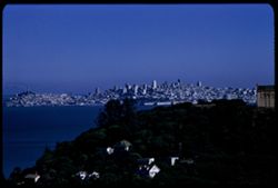
- Description:
- 100 f 6.3 TL
- Subject:
- Paradise Bay (Marin County, Calif.), Hills, Mountains, Trees, Piers & wharves, Houses, Bays (Bodies of water), and Buildings
- Series:
- 22-61
- Creator:
- Cushman, Charles W., 1896-1972
- Date Created:
- 1961-10-06
- Genre:
- Marine photographs and Cityscape photographs
- Frame Number:
- 3
- County:
- Marin
- Abstract:
- Paradise Cay
- Call Number:
- P12494
- Country:
- United States
- State/Province:
- California
- Alternate Identifier:
- 2261.3
- Persistent URL:
- http://purl.dlib.indiana.edu/iudl/archives/cushman/P12494
- Holding Location:
- Bloomington - University Archives
Wells Library E460
1320 E 10th St.
Bloomington, IN 47405
Contact at archives@indiana.edu, 812-855-1127
-
- Description:
- 100 f 5.6 sl - 50mm
- Subject:
- Peninsulas, Sandbars, Hills, Bolinas Lagoon (Calif.), Bays (Bodies of water), Tamalpais, Mount (Calif.), Trees, Coastlines, and Seas
- Series:
- 2-56
- Creator:
- Cushman, Charles W., 1896-1972
- Date Created:
- 1956-03-14
- Genre:
- Landscape photographs
- Frame Number:
- 7
- County:
- Marin
- Abstract:
- Looking down on Bolinas Lagoon
- Call Number:
- P08573
- City:
- Bolinas
- Country:
- United States
- State/Province:
- California
- Alternate Identifier:
- 256.7
- Persistent URL:
- http://purl.dlib.indiana.edu/iudl/archives/cushman/P08573
- Holding Location:
- Bloomington - University Archives
Wells Library E460
1320 E 10th St.
Bloomington, IN 47405
Contact at archives@indiana.edu, 812-855-1127
-
- Description:
- 100 f 6.3 tl
- Subject:
- Cities & towns, San Francisco Bay (Calif.), Mountains, Tamalpais, Mount (Calif.), and Bays (Bodies of water)
- Series:
- 15-57
- Creator:
- Cushman, Charles W., 1896-1972
- Date Created:
- 1957-10-03
- Genre:
- Landscape photographs, Cityscape photographs, and Views
- Frame Number:
- 29
- County:
- Marin
- Abstract:
- Toward San Rafael
- Call Number:
- P09559
- City:
- San Rafael
- Country:
- United States
- State/Province:
- California
- Alternate Identifier:
- 1557.29
- Persistent URL:
- http://purl.dlib.indiana.edu/iudl/archives/cushman/P09559
- Holding Location:
- Bloomington - University Archives
Wells Library E460
1320 E 10th St.
Bloomington, IN 47405
Contact at archives@indiana.edu, 812-855-1127
-
- Description:
- 100 f 8 tl
- Subject:
- Point Reyes (Calif.), Capes (Coasts), Mounds (Landforms), Bays (Bodies of water), Rocks, Coastlines, Plants, and Bolinas Bay (Calif.)
- Series:
- 2-56
- Creator:
- Cushman, Charles W., 1896-1972
- Date Created:
- 1956-03-14
- Genre:
- Landscape photographs
- Frame Number:
- 1
- Street Address:
- California State Highway 1
- County:
- Marin
- Abstract:
- From Calif 1, looking toward Bolinas headland and beyond to Pt. Reyes
- Call Number:
- P08567
- City:
- San Quentin and Bolinas
- Country:
- United States
- State/Province:
- California
- Alternate Identifier:
- 256.1
- Persistent URL:
- http://purl.dlib.indiana.edu/iudl/archives/cushman/P08567
- Holding Location:
- Bloomington - University Archives
Wells Library E460
1320 E 10th St.
Bloomington, IN 47405
Contact at archives@indiana.edu, 812-855-1127
-
- Description:
- 100 f 6.3 tl
- Subject:
- Diablo, Mount (Calif.), San Francisco Bay (Calif.), Bays (Bodies of water), Tamalpais, Mount (Calif.), Rocks, Coastlines, Clouds, Mists, and Mountains
- Series:
- 14-56
- Creator:
- Cushman, Charles W., 1896-1972
- Date Created:
- 1956-11-07
- Genre:
- Landscape photographs
- Frame Number:
- 25
- County:
- Marin and Contra Costa
- Abstract:
- Mt. Diablo from Tamalpais
- Call Number:
- P09022
- Country:
- United States
- State/Province:
- California
- Alternate Identifier:
- 1456.25
- Persistent URL:
- http://purl.dlib.indiana.edu/iudl/archives/cushman/P09022
- Holding Location:
- Bloomington - University Archives
Wells Library E460
1320 E 10th St.
Bloomington, IN 47405
Contact at archives@indiana.edu, 812-855-1127
-
- Description:
- 100 f 6.3 tl
- Subject:
- Cities & towns, Hills, Roads, Mountains, Tamalpais, Mount (Calif.), Shadows, San Bruno Mountain (Calif.), and Bays (Bodies of water)
- Series:
- 29-55
- Creator:
- Cushman, Charles W., 1896-1972
- Date Created:
- 1955-10-31
- Genre:
- Landscape photographs and Cityscape photographs
- Frame Number:
- 10
- County:
- Marin and San Francisco
- Abstract:
- Toward SE - to San Bruno Mtn
- Call Number:
- P08501
- City:
- San Francisco
- Country:
- United States
- State/Province:
- California
- Alternate Identifier:
- 2955.10
- Persistent URL:
- http://purl.dlib.indiana.edu/iudl/archives/cushman/P08501
- Holding Location:
- Bloomington - University Archives
Wells Library E460
1320 E 10th St.
Bloomington, IN 47405
Contact at archives@indiana.edu, 812-855-1127
-
- Description:
- 100 f 5.6 tl
- Subject:
- Bolinas Lagoon (Calif.), Bays (Bodies of water), Tamalpais, Mount (Calif.), Land, Coastlines, and Trees
- Series:
- 29-55
- Creator:
- Cushman, Charles W., 1896-1972
- Date Created:
- 1955-11-06
- Genre:
- Landscape photographs
- Frame Number:
- 15
- Street Address:
- Ridgecrest Road
- County:
- Marin
- Abstract:
- Bolinas Lagoon at low tide from Ridgecrest road high above on east
- Call Number:
- P08506
- Country:
- United States
- State/Province:
- California
- Alternate Identifier:
- 2955.15
- Persistent URL:
- http://purl.dlib.indiana.edu/iudl/archives/cushman/P08506
- Holding Location:
- Bloomington - University Archives
Wells Library E460
1320 E 10th St.
Bloomington, IN 47405
Contact at archives@indiana.edu, 812-855-1127
-
- Description:
- 100 f 8 tl
- Subject:
- Richmond-San Rafael Bridge, Girders, Bridge construction, Hills, San Francisco Bay (Calif.), Bridges, and Bays (Bodies of water)
- Series:
- 1-56
- Creator:
- Cushman, Charles W., 1896-1972
- Date Created:
- 1956-03-07
- Genre:
- Seascapes
- Frame Number:
- 37
- County:
- Marin and Contra Costa
- Abstract:
- Center span of new bridge from road near navy depot
- Call Number:
- P08566
- City:
- San Rafael and Richmond
- Country:
- United States
- State/Province:
- California
- Alternate Identifier:
- 156.37
- Persistent URL:
- http://purl.dlib.indiana.edu/iudl/archives/cushman/P08566
- Holding Location:
- Bloomington - University Archives
Wells Library E460
1320 E 10th St.
Bloomington, IN 47405
Contact at archives@indiana.edu, 812-855-1127
-
- Description:
- 100 f 8 tl
- Subject:
- Sandbars, Bolinas Lagoon (Calif.), Bays (Bodies of water), Tamalpais, Mount (Calif.), Coastlines, Bolinas Bay (Calif.), Seas, and Beaches
- Series:
- 2-57
- Creator:
- Cushman, Charles W., 1896-1972
- Date Created:
- 1957-03-22
- Genre:
- Landscape photographs
- Frame Number:
- 4
- County:
- Marin
- Abstract:
- Bolinas sand bar
- Call Number:
- P09130
- City:
- Bolinas
- Country:
- United States
- State/Province:
- California
- Physical Description:
- Image was originally mounted in a glass enclosure. Before digitization, the image was removed and placed in a Wess Plastic, Inc. brand, 2" x 2", pl...
- Alternate Identifier:
- 257.4
- Persistent URL:
- http://purl.dlib.indiana.edu/iudl/archives/cushman/P09130
- Holding Location:
- Bloomington - University Archives
Wells Library E460
1320 E 10th St.
Bloomington, IN 47405
Contact at archives@indiana.edu, 812-855-1127
-
- Description:
- 100 f 6.3 tl
- Subject:
- Richmond-San Rafael Bridge, Cities & towns, Haze, Bays (Bodies of water), Tamalpais, Mount (Calif.), and Construction
- Series:
- 28-55
- Creator:
- Cushman, Charles W., 1896-1972
- Date Created:
- 1955-10-12
- Genre:
- Cityscape photographs
- Frame Number:
- 22
- County:
- Marin
- Abstract:
- Richmond - San Rafael bridge abuilding - from Tamalpais in smoke haze
- Call Number:
- P08477
- City:
- San Rafael
- Country:
- United States
- State/Province:
- California
- Alternate Identifier:
- 2855.22
- Persistent URL:
- http://purl.dlib.indiana.edu/iudl/archives/cushman/P08477
- Holding Location:
- Bloomington - University Archives
Wells Library E460
1320 E 10th St.
Bloomington, IN 47405
Contact at archives@indiana.edu, 812-855-1127
-
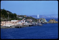
- Description:
- 100 f 8 tl
- Subject:
- Bays (Bodies of water), Piers & wharves, Houses, Warehouses, Boats, Roofs, Harbors, Ships, Waterfronts, San Francisco Bay (Calif.), and Trees
- Series:
- 12-56
- Creator:
- Cushman, Charles W., 1896-1972
- Date Created:
- 1956-09-08
- Genre:
- Marine photographs and Views
- Frame Number:
- 30
- County:
- Marin
- Abstract:
- Small boat harbor from Sausalito
- Call Number:
- P08965
- City:
- Sausalito
- Country:
- United States
- State/Province:
- California
- Alternate Identifier:
- 1256.30
- Persistent URL:
- http://purl.dlib.indiana.edu/iudl/archives/cushman/P08965
- Holding Location:
- Bloomington - University Archives
Wells Library E460
1320 E 10th St.
Bloomington, IN 47405
Contact at archives@indiana.edu, 812-855-1127
-
- Description:
- 25 f 8 Pola
- Subject:
- Bays (Bodies of water), Grasses, Roads, Golden Gate Bridge (San Francisco, Calif.), Fog, Trees, Mountains, Buildings, Tunnels, Hills, Waldo Tunnel (Calif.), ...
- Series:
- 7-53
- Creator:
- Cushman, Charles W., 1896-1972
- Date Created:
- 1953-07-08
- Genre:
- Views
- Frame Number:
- 25
- County:
- Marin and San Francisco
- Abstract:
- Fog through the Golden Gate from Waldo Tunnel entrance.
- Call Number:
- P06750
- City:
- San Francisco
- Country:
- United States
- State/Province:
- California
- Alternate Identifier:
- 753.25
- Persistent URL:
- http://purl.dlib.indiana.edu/iudl/archives/cushman/P06750
- Holding Location:
- Bloomington - University Archives
Wells Library E460
1320 E 10th St.
Bloomington, IN 47405
Contact at archives@indiana.edu, 812-855-1127
-
- Description:
- 100 f 5.6
- Subject:
- Bays (Bodies of water), Vessels, Bodies of water, Automobiles, Bridge construction, Signs (Notices), El Paso (Ferry), Ferries, Hills, Russian River (Ferry), ...
- Series:
- 2-54
- Creator:
- Cushman, Charles W., 1896-1972
- Date Created:
- 1954-05-21
- Genre:
- Marine photographs
- Frame Number:
- 9
- County:
- Marin and Contra Costa
- Abstract:
- Aboard Ferry Boat Russian River from San Rafael to Richmond Ferry boat Klamath [sic] - starboard
- Call Number:
- P07139
- City:
- Richmond and San Rafael
- Country:
- United States
- State/Province:
- California
- Alternate Identifier:
- 254.9
- Persistent URL:
- http://purl.dlib.indiana.edu/iudl/archives/cushman/P07139
- Holding Location:
- Bloomington - University Archives
Wells Library E460
1320 E 10th St.
Bloomington, IN 47405
Contact at archives@indiana.edu, 812-855-1127
-
- Description:
- 100 f 6.3 tl
- Subject:
- Bays (Bodies of water), Stinson Beach (Calif.), Houses, Bolinas Lagoon (Calif.), Trees, Boulders, Bolinas Bay (Calif.), Beaches, Hills, Seas, and Coastlines
- Series:
- 29-55
- Creator:
- Cushman, Charles W., 1896-1972
- Date Created:
- 1955-10-31
- Genre:
- Landscape photographs
- Frame Number:
- 1
- County:
- Marin
- Abstract:
- from above [P]
- Call Number:
- P08492
- Country:
- United States
- State/Province:
- California
- Alternate Identifier:
- 2955.1
- Persistent URL:
- http://purl.dlib.indiana.edu/iudl/archives/cushman/P08492
- Holding Location:
- Bloomington - University Archives
Wells Library E460
1320 E 10th St.
Bloomington, IN 47405
Contact at archives@indiana.edu, 812-855-1127
-
- Description:
- 50 f 8
- Subject:
- Bays (Bodies of water), Piers & wharves, Houses, Angel Island (Calif.), Boats, Streets, Tree limbs, Richardson Bay (Calif.), Ships, Islands, Dwellings, S...
- Series:
- 8-53
- Creator:
- Cushman, Charles W., 1896-1972
- Date Created:
- 1953-08-30
- Genre:
- Marine photographs
- Frame Number:
- 9
- County:
- Marin
- Abstract:
- Sausalito harbor.
- Call Number:
- P06771
- City:
- Sausalito
- Country:
- United States
- State/Province:
- California
- Alternate Identifier:
- 853.9
- Persistent URL:
- http://purl.dlib.indiana.edu/iudl/archives/cushman/P06771
- Holding Location:
- Bloomington - University Archives
Wells Library E460
1320 E 10th St.
Bloomington, IN 47405
Contact at archives@indiana.edu, 812-855-1127
-
- Description:
- 100 f 8 tl
- Subject:
- Bays (Bodies of water), Skyscrapers, San Francisco-Oakland Bay Bridge (Oakland and San Francisco, Calif.), Roofs, Telegraph Hill (San Francisco, Calif.), Bui...
- Series:
- 12-56
- Creator:
- Cushman, Charles W., 1896-1972
- Date Created:
- 1956-09-08
- Genre:
- Cityscape photographs
- Frame Number:
- 33
- County:
- Marin and San Francisco
- Abstract:
- SF from hts of Sausalito
- Call Number:
- P08968
- City:
- Sausalito and San Francisco
- Country:
- United States
- State/Province:
- California
- Alternate Identifier:
- 1256.33
- Persistent URL:
- http://purl.dlib.indiana.edu/iudl/archives/cushman/P08968
- Holding Location:
- Bloomington - University Archives
Wells Library E460
1320 E 10th St.
Bloomington, IN 47405
Contact at archives@indiana.edu, 812-855-1127
-
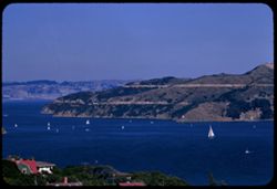
- Description:
- 100 f 8 tl
- Subject:
- Bays (Bodies of water), Sailboats, Angel Island (Calif.), Trees, Coastlines, Roofs, Richardson Bay (Calif.), Waterfronts, and Islands
- Series:
- 12-56
- Creator:
- Cushman, Charles W., 1896-1972
- Date Created:
- 1956-09-08
- Genre:
- Landscape photographs
- Frame Number:
- 34
- County:
- Marin
- Abstract:
- Angel Island from Sausalito
- Call Number:
- P08969
- City:
- Sausalito
- Country:
- United States
- State/Province:
- California
- Alternate Identifier:
- 1256.34
- Persistent URL:
- http://purl.dlib.indiana.edu/iudl/archives/cushman/P08969
- Holding Location:
- Bloomington - University Archives
Wells Library E460
1320 E 10th St.
Bloomington, IN 47405
Contact at archives@indiana.edu, 812-855-1127
-
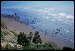
- Description:
- 100 f 5.6
- Subject:
- Rocks, Bays (Bodies of water), Oceans, Seas, Grasses, Cliffs, Trees, Coastlines, Bolinas Bay (Calif.), and Beaches
- Series:
- 1-68
- Creator:
- Cushman, Charles W., 1896-1972
- Date Created:
- 1968-03-20
- Genre:
- Seascapes
- Frame Number:
- 30
- County:
- Marin
- Abstract:
- Down on Bolinas beach
- Call Number:
- P15624
- City:
- Bolinas
- Country:
- United States
- State/Province:
- California
- Alternate Identifier:
- 168.30
- Persistent URL:
- http://purl.dlib.indiana.edu/iudl/archives/cushman/P15624
- Holding Location:
- Bloomington - University Archives
Wells Library E460
1320 E 10th St.
Bloomington, IN 47405
Contact at archives@indiana.edu, 812-855-1127
-
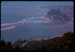
- Description:
- 100 f 11 tl
- Subject:
- Bays (Bodies of water), Oceans, Seas, Bolinas Lagoon (Calif.), Coastlines, Bolinas Bay (Calif.), Tamalpais, Mount (Calif.), Hills, and Sandbars
- Series:
- 26-65
- Creator:
- Cushman, Charles W., 1896-1972
- Date Created:
- 1965-07-09
- Genre:
- Landscape photographs and Seascapes
- Frame Number:
- 35
- County:
- Marin
- Call Number:
- P14796
- Country:
- United States
- State/Province:
- California
- Alternate Identifier:
- 2665.35
- Persistent URL:
- http://purl.dlib.indiana.edu/iudl/archives/cushman/P14796
- Holding Location:
- Bloomington - University Archives
Wells Library E460
1320 E 10th St.
Bloomington, IN 47405
Contact at archives@indiana.edu, 812-855-1127
-
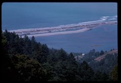
- Description:
- 100 f 11 tl
- Subject:
- Bays (Bodies of water), Oceans, Seas, Bolinas Lagoon (Calif.), Trees, Coastlines, Bolinas Bay (Calif.), Mountains, Beaches, Forests, Hills, and Sandbars
- Series:
- 26-65
- Creator:
- Cushman, Charles W., 1896-1972
- Date Created:
- 1965-07-09
- Genre:
- Landscape photographs and Seascapes
- Frame Number:
- 36
- County:
- Marin
- Call Number:
- P14797
- Country:
- United States
- State/Province:
- California
- Alternate Identifier:
- 2665.36
- Persistent URL:
- http://purl.dlib.indiana.edu/iudl/archives/cushman/P14797
- Holding Location:
- Bloomington - University Archives
Wells Library E460
1320 E 10th St.
Bloomington, IN 47405
Contact at archives@indiana.edu, 812-855-1127
-
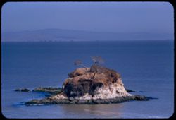
- Description:
- 100 f 6.3 tl
- Subject:
- Bays (Bodies of water), San Pablo Bay (Calif.), Cliffs, Trees, Coastlines, Shrubs, and Islands
- Series:
- 12-56
- Creator:
- Cushman, Charles W., 1896-1972
- Date Created:
- 1956-08-14
- Genre:
- Seascapes
- Frame Number:
- 18
- County:
- Marin
- Abstract:
- Small island nearby
- Call Number:
- P08953
- City:
- China Camp
- Country:
- United States
- State/Province:
- California
- Alternate Identifier:
- 1256.18
- Persistent URL:
- http://purl.dlib.indiana.edu/iudl/archives/cushman/P08953
- Holding Location:
- Bloomington - University Archives
Wells Library E460
1320 E 10th St.
Bloomington, IN 47405
Contact at archives@indiana.edu, 812-855-1127
-
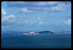
- Description:
- 100 f 11 TL
- Subject:
- Bays (Bodies of water), United States Penitentiary, Alcatraz Island, California, Suspension bridges, San Francisco-Oakland Bay Bridge (Oakland and San Franci...
- Series:
- 1-63
- Creator:
- Cushman, Charles W., 1896-1972
- Date Created:
- 1963-04-09
- Genre:
- Marine photographs and Identification photographs
- Frame Number:
- 15
- County:
- Marin and San Francisco
- Abstract:
- Alcatraz from Marin
- Call Number:
- P12819
- City:
- San Francisco
- Country:
- United States
- State/Province:
- California
- Alternate Identifier:
- 163.15
- Persistent URL:
- http://purl.dlib.indiana.edu/iudl/archives/cushman/P12819
- Holding Location:
- Bloomington - University Archives
Wells Library E460
1320 E 10th St.
Bloomington, IN 47405
Contact at archives@indiana.edu, 812-855-1127
-
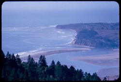
- Description:
- 100 f 5.6 tl
- Subject:
- Bays (Bodies of water), Seas, Bolinas Lagoon (Calif.), Coastlines, Bolinas Bay (Calif.), Cities & towns, Land, Forests, Sandbars, Firs, and Tamalpais, Mo...
- Series:
- 29-55
- Creator:
- Cushman, Charles W., 1896-1972
- Date Created:
- 1955-11-06
- Genre:
- Landscape photographs
- Frame Number:
- 16
- Street Address:
- Ridgecrest Road
- County:
- Marin
- Abstract:
- Bolinas Bay from Ridgecrest Rd
- Call Number:
- P08507
- City:
- Bolinas
- Country:
- United States
- State/Province:
- California
- Alternate Identifier:
- 2955.16
- Persistent URL:
- http://purl.dlib.indiana.edu/iudl/archives/cushman/P08507
- Holding Location:
- Bloomington - University Archives
Wells Library E460
1320 E 10th St.
Bloomington, IN 47405
Contact at archives@indiana.edu, 812-855-1127
-
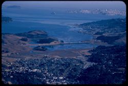
- Description:
- 100 f 6.3 tl
- Subject:
- Bays (Bodies of water), Seas, Trees, Cities & towns, Richardson Bay (Calif.), Peninsulas, Bridges, Tamalpais, Mount (Calif.), San Francisco Bay (Calif.),...
- Series:
- 29-55
- Creator:
- Cushman, Charles W., 1896-1972
- Date Created:
- 1955-10-31
- Genre:
- Landscape photographs and Cityscape photographs
- Frame Number:
- 11
- County:
- Marin and San Francisco
- Abstract:
- Richardson Bay Bridge
- Call Number:
- P08502
- City:
- San Francisco
- Country:
- United States
- State/Province:
- California
- Alternate Identifier:
- 2955.11
- Persistent URL:
- http://purl.dlib.indiana.edu/iudl/archives/cushman/P08502
- Holding Location:
- Bloomington - University Archives
Wells Library E460
1320 E 10th St.
Bloomington, IN 47405
Contact at archives@indiana.edu, 812-855-1127
-
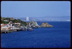
- Description:
- 100 f 8 tl
- Subject:
- Bays (Bodies of water), Piers & wharves, Channels, Houses, Buildings, Ferries, Raccoon Strait (Calif.), Utility poles, and Hills
- Series:
- 1-60
- Creator:
- Cushman, Charles W., 1896-1972
- Date Created:
- 1960-02-02
- Genre:
- Marine photographs and Cityscape photographs
- Frame Number:
- 7
- County:
- Marin
- Abstract:
- Car ferry up Raccoon Strait
- Call Number:
- P10901
- City:
- Tiburon
- Country:
- United States
- State/Province:
- California
- Alternate Identifier:
- 160.7
- Persistent URL:
- http://purl.dlib.indiana.edu/iudl/archives/cushman/P10901
- Holding Location:
- Bloomington - University Archives
Wells Library E460
1320 E 10th St.
Bloomington, IN 47405
Contact at archives@indiana.edu, 812-855-1127
-
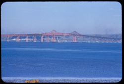
- Description:
- 100 f 6.3 tl
- Subject:
- Bays (Bodies of water), Girders, Richmond-San Rafael Bridge, Bridge construction, Bridges, Hills, and San Francisco Bay (Calif.)
- Series:
- 1-56
- Creator:
- Cushman, Charles W., 1896-1972
- Date Created:
- 1956-03-07
- Genre:
- Seascapes
- Frame Number:
- 36
- County:
- Marin and Contra Costa
- Abstract:
- Final day for new San Rafael-Richmond bridge - center span placed
- Call Number:
- P08565
- City:
- San Quentin, Richmond, and San Rafael
- Country:
- United States
- State/Province:
- California
- Alternate Identifier:
- 156.36
- Persistent URL:
- http://purl.dlib.indiana.edu/iudl/archives/cushman/P08565
- Holding Location:
- Bloomington - University Archives
Wells Library E460
1320 E 10th St.
Bloomington, IN 47405
Contact at archives@indiana.edu, 812-855-1127
-
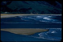
- Description:
- 100 f 8 tl
- Subject:
- Bays (Bodies of water), Seas, Sandbars, Coastlines, Bolinas Bay (Calif.), Beaches, and Waterfronts
- Series:
- 2-57
- Creator:
- Cushman, Charles W., 1896-1972
- Date Created:
- 1957-03-22
- Genre:
- Landscape photographs
- Frame Number:
- 5
- County:
- Marin
- Abstract:
- Surf of Bolinas Bay from town of Bolinas
- Call Number:
- P09131
- City:
- Bolinas
- Country:
- United States
- State/Province:
- California
- Alternate Identifier:
- 257.5
- Persistent URL:
- http://purl.dlib.indiana.edu/iudl/archives/cushman/P09131
- Holding Location:
- Bloomington - University Archives
Wells Library E460
1320 E 10th St.
Bloomington, IN 47405
Contact at archives@indiana.edu, 812-855-1127
-
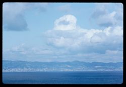
- Description:
- 100 f 9 TL
- Subject:
- Bays (Bodies of water), Coastlines, Clouds, and San Francisco Bay (Calif.)
- Series:
- 1-63
- Creator:
- Cushman, Charles W., 1896-1972
- Date Created:
- 1963-04-09
- Genre:
- Landscape photographs
- Frame Number:
- 18
- County:
- Marin and Alameda
- Abstract:
- Cloud mass above Berkeley - Oakland - from Marin
- Call Number:
- P12822
- City:
- Oakland, Sausalito, and Berkeley
- Country:
- United States
- State/Province:
- California
- Alternate Identifier:
- 163.18
- Persistent URL:
- http://purl.dlib.indiana.edu/iudl/archives/cushman/P12822
- Holding Location:
- Bloomington - University Archives
Wells Library E460
1320 E 10th St.
Bloomington, IN 47405
Contact at archives@indiana.edu, 812-855-1127
-
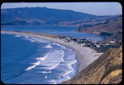
- Description:
- 100 f 6.3 tl
- Subject:
- Bays (Bodies of water), Stinson Beach (Calif.), Houses, Bolinas Lagoon (Calif.), Trees, Coastlines, Beaches, Hills, and Seas
- Series:
- 29-55
- Creator:
- Cushman, Charles W., 1896-1972
- Date Created:
- 1955-10-31
- Genre:
- Landscape photographs
- Frame Number:
- 2
- County:
- Marin
- Abstract:
- from above [L]
- Call Number:
- P08493
- Country:
- United States
- State/Province:
- California
- Alternate Identifier:
- 2955.2
- Persistent URL:
- http://purl.dlib.indiana.edu/iudl/archives/cushman/P08493
- Holding Location:
- Bloomington - University Archives
Wells Library E460
1320 E 10th St.
Bloomington, IN 47405
Contact at archives@indiana.edu, 812-855-1127
-
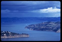
- Description:
- 100 f 6.3 TL
- Subject:
- Bays (Bodies of water), Channels, Waldo Height, Waldo Point Harbor (Calif.), Richardson Bay (Calif.), Clouds, Islands, Hills, and Raccoon Strait (Calif.)
- Series:
- 1-60
- Creator:
- Cushman, Charles W., 1896-1972
- Date Created:
- 1960-02-18
- Genre:
- Seascapes
- Frame Number:
- 30
- County:
- Marin
- Abstract:
- [Raccoon] Str.
- Call Number:
- P10923
- City:
- Sausalito
- Country:
- United States
- State/Province:
- California
- Alternate Identifier:
- 160.30
- Persistent URL:
- http://purl.dlib.indiana.edu/iudl/archives/cushman/P10923
- Holding Location:
- Bloomington - University Archives
Wells Library E460
1320 E 10th St.
Bloomington, IN 47405
Contact at archives@indiana.edu, 812-855-1127
-
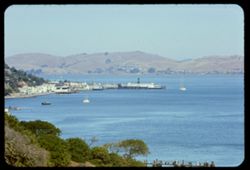
- Description:
- 250 f 8 tl
- Subject:
- Bays (Bodies of water), Piers & wharves, Boats, Buildings, Hills, Trees, and Richardson Bay (Calif.)
- Series:
- 15-59
- Creator:
- Cushman, Charles W., 1896-1972
- Date Created:
- 1959-08-25
- Genre:
- Marine photographs, Seascapes, Views, and Cityscape photographs
- Frame Number:
- 17
- County:
- Marin
- Abstract:
- View up Richardson Bay past Sausalito
- Call Number:
- P10856
- City:
- Sausalito
- Country:
- United States
- State/Province:
- California
- Physical Description:
- Anscochrome film.
- Alternate Identifier:
- 1559.17
- Persistent URL:
- http://purl.dlib.indiana.edu/iudl/archives/cushman/P10856
- Holding Location:
- Bloomington - University Archives
Wells Library E460
1320 E 10th St.
Bloomington, IN 47405
Contact at archives@indiana.edu, 812-855-1127
-
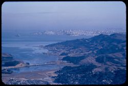
- Description:
- 100 f 5.6 tl
- Subject:
- Bays (Bodies of water), Richardson Bay Bridge (Calif.), Skyscrapers, Cities & towns, Buildings, Bridges, Tamalpais, Mount (Calif.), Hills, San Francisco ...
- Series:
- 29-55
- Creator:
- Cushman, Charles W., 1896-1972
- Date Created:
- 1955-10-31
- Genre:
- Landscape photographs and Cityscape photographs
- Frame Number:
- 9
- County:
- Marin and San Francisco
- Abstract:
- Toward Sausalito & SF
- Call Number:
- P08500
- City:
- Sausalito and San Francisco
- Country:
- United States
- State/Province:
- California
- Alternate Identifier:
- 2955.9
- Persistent URL:
- http://purl.dlib.indiana.edu/iudl/archives/cushman/P08500
- Holding Location:
- Bloomington - University Archives
Wells Library E460
1320 E 10th St.
Bloomington, IN 47405
Contact at archives@indiana.edu, 812-855-1127
-
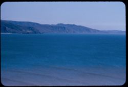
- Description:
- 100 f 6.3 tl
- Subject:
- Bays (Bodies of water), Seas, Bolinas Bay (Calif.), and Hills
- Series:
- 29-55
- Creator:
- Cushman, Charles W., 1896-1972
- Date Created:
- 1955-10-31
- Genre:
- Seascapes
- Frame Number:
- 4
- County:
- Marin
- Abstract:
- Southeast from same point - across Bolinas Bay
- Call Number:
- P08495
- City:
- Bolinas
- Country:
- United States
- State/Province:
- California
- Alternate Identifier:
- 2955.4
- Persistent URL:
- http://purl.dlib.indiana.edu/iudl/archives/cushman/P08495
- Holding Location:
- Bloomington - University Archives
Wells Library E460
1320 E 10th St.
Bloomington, IN 47405
Contact at archives@indiana.edu, 812-855-1127
-
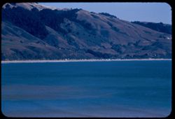
- Description:
- 100 f 6.3 tl
- Subject:
- Bays (Bodies of water), Seas, Trees, Bolinas Bay (Calif.), Cities & towns, Beaches, and Hills
- Series:
- 29-55
- Creator:
- Cushman, Charles W., 1896-1972
- Date Created:
- 1955-10-31
- Genre:
- Seascapes
- Frame Number:
- 3
- County:
- Marin
- Abstract:
- Toward town of Stinson Beach - from heights back of Bolinas
- Call Number:
- P08494
- City:
- Stinson Beach and Bolinas
- Country:
- United States
- State/Province:
- California
- Alternate Identifier:
- 2955.3
- Persistent URL:
- http://purl.dlib.indiana.edu/iudl/archives/cushman/P08494
- Holding Location:
- Bloomington - University Archives
Wells Library E460
1320 E 10th St.
Bloomington, IN 47405
Contact at archives@indiana.edu, 812-855-1127
-
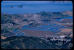
- Description:
- 100 f 8 tl
- Subject:
- Bays (Bodies of water), Channels, Trees, San Pablo Strait (Calif.), Cities & towns, Waterfronts, Islands, Tamalpais, Mount (Calif.), Hills, and Canals
- Series:
- 2-56
- Creator:
- Cushman, Charles W., 1896-1972
- Date Created:
- 1956-03-14
- Genre:
- Landscape photographs and Cityscape photographs
- Frame Number:
- 15
- County:
- Marin
- Abstract:
- Toward San Pablo Strait
- Call Number:
- P08581
- Country:
- United States
- State/Province:
- California
- Alternate Identifier:
- 256.15
- Persistent URL:
- http://purl.dlib.indiana.edu/iudl/archives/cushman/P08581
- Holding Location:
- Bloomington - University Archives
Wells Library E460
1320 E 10th St.
Bloomington, IN 47405
Contact at archives@indiana.edu, 812-855-1127
-
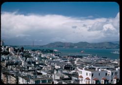
- Description:
- 25 f 6.3 pola
- Subject:
- Bays (Bodies of water), Apartment houses, Golden Gate Bridge (San Francisco, Calif.), Suspension bridges, Roofs, Mountains, Buildings, Clouds, Coit Memorial ...
- Series:
- 10-52
- Creator:
- Cushman, Charles W., 1896-1972
- Date Created:
- 1952-03-12
- Genre:
- Cityscape photographs
- Frame Number:
- 17
- County:
- Marin and San Francisco
- Abstract:
- Golden Gate Bridge from Coit Tower [bse]
- Call Number:
- P05849
- City:
- San Francisco
- Country:
- United States
- State/Province:
- California
- Alternate Identifier:
- 1052.17
- Persistent URL:
- http://purl.dlib.indiana.edu/iudl/archives/cushman/P05849
- Holding Location:
- Bloomington - University Archives
Wells Library E460
1320 E 10th St.
Bloomington, IN 47405
Contact at archives@indiana.edu, 812-855-1127
-
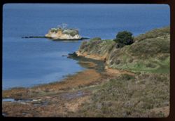
- Description:
- 100 f 8 tl
- Subject:
- Bays (Bodies of water), San Pablo Bay (Calif.), Grasses, Cliffs, Shrubs, and Islands
- Series:
- 27-60
- Creator:
- Cushman, Charles W., 1896-1972
- Date Created:
- 1961-01-31
- Genre:
- Landscape photographs
- Frame Number:
- 15
- County:
- Marin
- Abstract:
- San Pablo Bay- Islet near China Camp
- Call Number:
- P11757
- City:
- China Camp
- Country:
- United States
- State/Province:
- California
- Alternate Identifier:
- 2760.15
- Persistent URL:
- http://purl.dlib.indiana.edu/iudl/archives/cushman/P11757
- Holding Location:
- Bloomington - University Archives
Wells Library E460
1320 E 10th St.
Bloomington, IN 47405
Contact at archives@indiana.edu, 812-855-1127
-
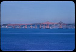
- Description:
- 100 f 8 tl
- Subject:
- Bays (Bodies of water), Girders, Richmond-San Rafael Bridge, Bridge construction, Bridges, Hills, and San Francisco Bay (Calif.)
- Series:
- 1-56
- Creator:
- Cushman, Charles W., 1896-1972
- Date Created:
- 1956-03-07
- Genre:
- Seascapes
- Frame Number:
- 35
- County:
- Marin and Contra Costa
- Abstract:
- Final day for new San Rafael-Richmond bridge - center span placed
- Call Number:
- P08564
- City:
- Richmond and San Rafael
- Country:
- United States
- State/Province:
- California
- Alternate Identifier:
- 156.35
- Persistent URL:
- http://purl.dlib.indiana.edu/iudl/archives/cushman/P08564
- Holding Location:
- Bloomington - University Archives
Wells Library E460
1320 E 10th St.
Bloomington, IN 47405
Contact at archives@indiana.edu, 812-855-1127
-
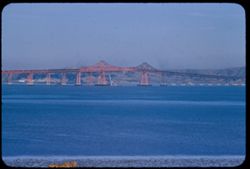
- Description:
- 100 f 6.3 tl
- Subject:
- Bays (Bodies of water), Girders, Richmond-San Rafael Bridge, Bridge construction, Bridges, Hills, and San Francisco Bay (Calif.)
- Series:
- 1-56
- Creator:
- Cushman, Charles W., 1896-1972
- Date Created:
- 1956-03-07
- Genre:
- Seascapes
- Frame Number:
- 34
- County:
- Marin and Contra Costa
- Abstract:
- Final day for new San Rafael-Richmond bridge - center span placed
- Call Number:
- P08563
- City:
- San Quentin, Richmond, and San Rafael
- Country:
- United States
- State/Province:
- California
- Alternate Identifier:
- 156.34
- Persistent URL:
- http://purl.dlib.indiana.edu/iudl/archives/cushman/P08563
- Holding Location:
- Bloomington - University Archives
Wells Library E460
1320 E 10th St.
Bloomington, IN 47405
Contact at archives@indiana.edu, 812-855-1127