
Search Constraints
You searched for:
Campus
IUB
Remove constraint Campus: IUB
County
Marin
Remove constraint County: Marin
Subject
Tamalpais, Mount (Calif.)
Remove constraint Subject: Tamalpais, Mount (Calif.)
1 - 56 of 56
Search Results
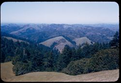
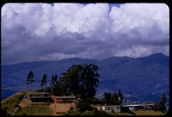
-
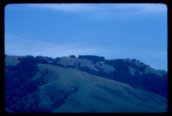
- Subject:
- Trees, Mountains, Tamalpais, Mount (Calif.), and Hills
- Series:
- 1-68
- Creator:
- Cushman, Charles W., 1896-1972
- Date Created:
- 1968-03-20
- Genre:
- Landscape photographs
- Frame Number:
- 31
- County:
- Marin
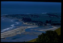
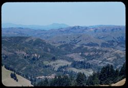
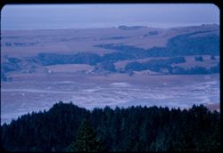
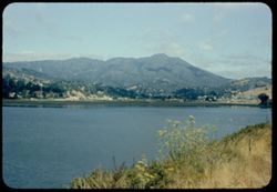
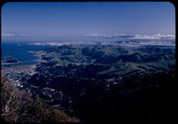
- Abstract:
- Toward Tamalpais from Bolinas
- Call Number:
- P15625
- City:
- Bolinas
- Country:
- United States
- State/Province:
- California
- Alternate Identifier:
- 168.31
- Persistent URL:
- http://purl.dlib.indiana.edu/iudl/archives/cushman/P15625
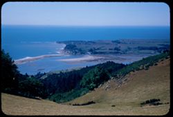
-
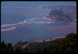
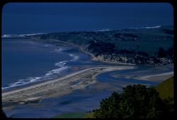
- Description:
- 100 f 11 tl
- Subject:
- Bays (Bodies of water), Oceans, Seas, Bolinas Lagoon (Calif.), Coastlines, Bolinas Bay (Calif.), Tamalpais, Mount (Calif.), Hills, and Sandbars
- Series:
- 26-65
- Creator:
- Cushman, Charles W., 1896-1972
- Date Created:
- 1965-07-09
- Genre:
- Landscape photographs and Seascapes
- Frame Number:
- 35
- County:
- Marin
- Call Number:
- P14796
- Country:
- United States
- State/Province:
- California
- Alternate Identifier:
- 2665.35
- Persistent URL:
- http://purl.dlib.indiana.edu/iudl/archives/cushman/P14796
-
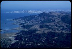
- Description:
- 100 f 6.3 tl
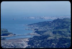
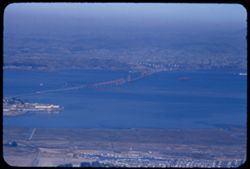
- Subject:
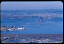
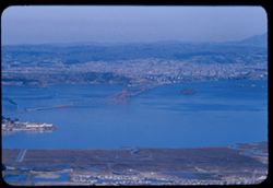
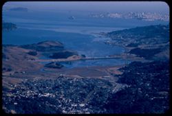
- Bays (Bodies of water), Mountains, Bridges, Tamalpais, Mount (Calif.), Hills, San Francisco Bay (Calif.), and Cities & towns
- Series:
- 15-57
- Creator:
- Cushman, Charles W., 1896-1972
- Date Created:
- 1957-10-03
- Genre:
- Cityscape photographs
- Frame Number:
- 33
- County:
- Marin and San Francisco
- Abstract:
- Marin hills above Sausalito from Tam.
- Call Number:
- P09563
- City:
- Sausalito and San Francisco
- Country:
- United States
- State/Province:
- California
- Alternate Identifier:
- 1557.33
- Persistent URL:
- http://purl.dlib.indiana.edu/iudl/archives/cushman/P09563
-
- Description:
- 100 f 6.3 tl
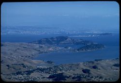
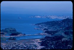
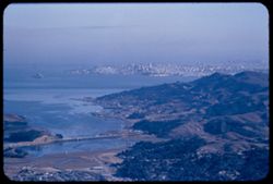
- Subject:
- Cities & towns, Bays (Bodies of water), Tamalpais, Mount (Calif.), Angel Island (Calif.), and Islands
- Series:
- 15-57
- Creator:
- Cushman, Charles W., 1896-1972
- Date Created:
- 1957-10-03
- Genre:
- Cityscape photographs and Views
- Frame Number:
- 32
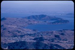
- County:
- Marin
- Abstract:
- Angel island
- Call Number:
- P09562
- City:
- Belvedere
- Country:
- United States
- State/Province:
- California
- Alternate Identifier:
- 1557.32
- Persistent URL:
- http://purl.dlib.indiana.edu/iudl/archives/cushman/P09562
-
- Description:
- 100 f 6.3 tl
- Subject:
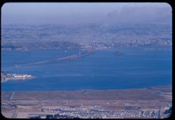
- Bays (Bodies of water), Richmond-San Rafael Bridge (Calif.), Mountains, Bridges, Tamalpais, Mount (Calif.), San Francisco Bay (Calif.), and Cities & towns
- Series:
- 15-57
- Creator:
- Cushman, Charles W., 1896-1972
- Date Created:
- 1957-10-03
- Genre:
- Views and Cityscape photographs
- Frame Number:
- 31
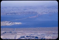
- County:
- Marin
- Abstract:
- Richmond - San Rafael Bridge
- Call Number:
- P09561
- Country:
- United States
- State/Province:
- California
- Alternate Identifier:
- 1557.31
- Persistent URL:
- http://purl.dlib.indiana.edu/iudl/archives/cushman/P09561
-
- Description:
- 100 f 6.3 tl
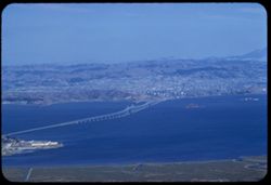
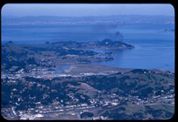
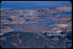
- Subject:
- Buildings, Cities & towns, Bays (Bodies of water), Corte Madera Creek (Marin County, Calif.), Tamalpais, Mount (Calif.), Rivers, Hills, and San Francisco...
- Series:
- 15-57
- Creator:
- Cushman, Charles W., 1896-1972
- Date Created:
- 1957-10-03
- Genre:
- Views and Cityscape photographs
- Frame Number:
- 30
- County:
- Marin
- Abstract:
- Mouth of Corte Madera ? Creek
- Call Number:
- P09560
- City:
- San Quentin
- Country:
- United States
- State/Province:
- California
- Alternate Identifier:
- 1557.30
- Persistent URL:
- http://purl.dlib.indiana.edu/iudl/archives/cushman/P09560
-
- Description:
- 100 f 6.3 tl
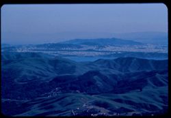
- Subject:
- Cities & towns, San Francisco Bay (Calif.), Mountains, Tamalpais, Mount (Calif.), and Bays (Bodies of water)
- Series:
- 15-57
- Creator:
- Cushman, Charles W., 1896-1972
- Date Created:
- 1957-10-03
- Genre:
- Landscape photographs, Cityscape photographs, and Views
- Frame Number:
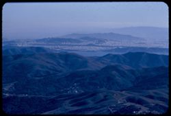
- 29
- County:
- Marin
- Abstract:
- Toward San Rafael
- Call Number:
- P09559
- City:
- San Rafael
- Country:
- United States
- State/Province:
- California
- Alternate Identifier:
- 1557.29
- Persistent URL:
- http://purl.dlib.indiana.edu/iudl/archives/cushman/P09559
-
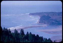
- Description:
- 100 f 8 tl
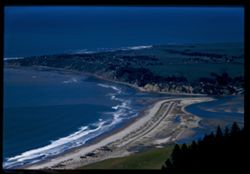
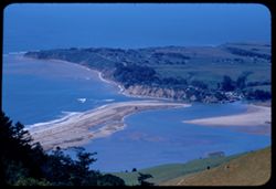
- Subject:
- Sandbars, Bolinas Lagoon (Calif.), Bays (Bodies of water), Tamalpais, Mount (Calif.), Coastlines, Bolinas Bay (Calif.), Seas, and Beaches
- Series:
- 2-57
- Creator:
- Cushman, Charles W., 1896-1972
- Date Created:
- 1957-03-22
- Genre:
- Landscape photographs
- Frame Number:
- 4
- County:
- Marin
- Abstract:
- Bolinas sand bar
- Call Number:
- P09130
- City:
- Bolinas
- Country:
- United States
- State/Province:
- California
- Physical Description:
- Image was originally mounted in a glass enclosure. Before digitization, the image was removed and placed in a Wess Plastic, Inc. brand, 2" x 2", pl...
- Alternate Identifier:
- 257.4
- Persistent URL:
- http://purl.dlib.indiana.edu/iudl/archives/cushman/P09130
-
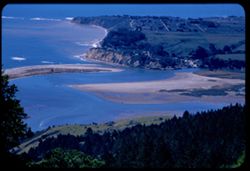
- Description:
- 100 f 8 tl
- Subject:
- Bays (Bodies of water), Seas, Sandbars, Coastlines, Bolinas Bay (Calif.), Beaches, Tamalpais, Mount (Calif.), and Bolinas Lagoon (Calif.)
- Series:
- 2-57
- Creator:
- Cushman, Charles W., 1896-1972
- Date Created:
- 1957-03-22
- Genre:
- Landscape photographs and Seascapes
- Frame Number:
- 3
- County:
- Marin
- Abstract:
- Tamalpais looking down on Bolinas
- Call Number:
- P09129
- City:
- Bolinas
- Country:
- United States
- State/Province:
- California
- Physical Description:
- Image was originally mounted in a glass enclosure. Before digitization, the image was removed and placed in a Wess Plastic, Inc. brand, 2" x 2", pl...
- Alternate Identifier:
- 257.3
- Persistent URL:
- http://purl.dlib.indiana.edu/iudl/archives/cushman/P09129
-
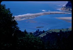
- Description:
- 100 f 7.8 tl
- Subject:
- Bays (Bodies of water), Seas, Bolinas Lagoon (Calif.), Coastlines, Bolinas Bay (Calif.), Beaches, Tamalpais, Mount (Calif.), and Sandbars
- Series:
- 2-57
- Creator:
- Cushman, Charles W., 1896-1972
- Date Created:
- 1957-03-22
- Genre:
- Landscape photographs and Seascapes
- Frame Number:
- 1
- County:
- Marin
- Abstract:
- Bolinas Bay from Tamalpais
- Call Number:
- P09128
- City:
- Bolinas
- Country:
- United States
- State/Province:
- California
- Alternate Identifier:
- 257.1
- Persistent URL:
- http://purl.dlib.indiana.edu/iudl/archives/cushman/P09128
-
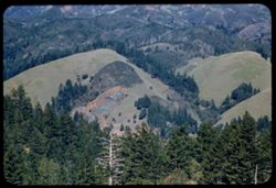
- Description:
- 100 f 8 tl
- Subject:
- Cities & towns, Mountains, Tamalpais, Mount (Calif.), and Buildings
- Series:
- 1-57
- Creator:
- Cushman, Charles W., 1896-1972
- Date Created:
- 1957-03-22
- Genre:
- Landscape photographs and Cityscape photographs
- Frame Number:
- 20
- County:
- Marin
- Abstract:
- Mt. Tamalpais from top of Waldo grade
- Call Number:
- P09126
- City:
- Waldo
- Country:
- United States
- State/Province:
- California
- Alternate Identifier:
- 157.20
- Persistent URL:
- http://purl.dlib.indiana.edu/iudl/archives/cushman/P09126
-
- Description:
- 100 f 6.3 tl
- Subject:
- Diablo, Mount (Calif.), San Francisco Bay (Calif.), Bays (Bodies of water), Tamalpais, Mount (Calif.), Rocks, Coastlines, Clouds, Mists, and Mountains
- Series:
- 14-56
- Creator:
- Cushman, Charles W., 1896-1972
- Date Created:
- 1956-11-07
- Genre:
- Landscape photographs
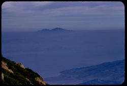
- Frame Number:
- 25
- County:
- Marin and Contra Costa
- Abstract:
- Mt. Diablo from Tamalpais
- Call Number:
- P09022
- Country:
- United States
- State/Province:
- California
- Alternate Identifier:
- 1456.25
- Persistent URL:
- http://purl.dlib.indiana.edu/iudl/archives/cushman/P09022
-
- Description:
- 100 f 8 tl
- Subject:
- Bays (Bodies of water), Richmond-San Rafael Bridge, Cities & towns, Bridges, Tamalpais, Mount (Calif.), Hills, and Canals
- Series:
- 2-56
- Creator:
- Cushman, Charles W., 1896-1972
- Date Created:
- 1956-03-14
- Genre:
- Landscape photographs and Cityscape photographs
- Frame Number:
- 18
- County:
- Marin and Contra Costa
- Abstract:
- San Rafael - Richm'd Bridge
- Call Number:
- P08584
- City:
- San Quentin, Richmond, and San Rafael
- Country:
- United States
- State/Province:
- California
- Alternate Identifier:
- 256.18
- Persistent URL:
- http://purl.dlib.indiana.edu/iudl/archives/cushman/P08584
-
- Description:
- 100 f 6.3 tl
- Subject:
- Cities & towns, Streets, Capes (Coasts), San Pablo Bay (Calif.), Bays (Bodies of water), Point San Pedro (Marin County, Calif.), Tamalpais, Mount (Calif....
- Series:
- 2-56
- Creator:
- Cushman, Charles W., 1896-1972
- Date Created:
- 1956-03-14
- Genre:
- Cityscape photographs
- Frame Number:
- 17
- County:
- Marin
- Abstract:
- Toward Pt. San Pedro
- Call Number:
- P08583
- Country:
- United States
- State/Province:
- California
- Alternate Identifier:
- 256.17
- Persistent URL:
- http://purl.dlib.indiana.edu/iudl/archives/cushman/P08583
-
- Description:
- 100 f 8 tl
- Subject:
- Bays (Bodies of water), Trees, Cities & towns, Bridges, Tamalpais, Mount (Calif.), Hills, San Francisco Bay (Calif.), and Canals
- Series:
- 2-56
- Creator:
- Cushman, Charles W., 1896-1972
- Date Created:
- 1956-03-14
- Genre:
- Cityscape photographs
- Frame Number:
- 16
- County:
- Marin and San Francisco
- Abstract:
- San Francisco
- Call Number:
- P08582
- City:
- San Francisco
- Country:
- United States
- State/Province:
- California
- Alternate Identifier:
- 256.16
- Persistent URL:
- http://purl.dlib.indiana.edu/iudl/archives/cushman/P08582
-
- Description:
- 100 f 8 tl
- Subject:
- Bays (Bodies of water), Channels, Trees, San Pablo Strait (Calif.), Cities & towns, Waterfronts, Islands, Tamalpais, Mount (Calif.), Hills, and Canals
- Series:
- 2-56
- Creator:
- Cushman, Charles W., 1896-1972
- Date Created:
- 1956-03-14
- Genre:
- Landscape photographs and Cityscape photographs
- Frame Number:
- 15
- County:
- Marin
- Abstract:
- Toward San Pablo Strait
- Call Number:
- P08581
- Country:
- United States
- State/Province:
- California
- Alternate Identifier:
- 256.15
- Persistent URL:
- http://purl.dlib.indiana.edu/iudl/archives/cushman/P08581
-
- Description:
- 100 f 8 tl
- Subject:
- Bays (Bodies of water), Richmond-San Rafael Bridge, Mountains, Bridges, Tamalpais, Mount (Calif.), Hills, Canals, and Cities & towns
- Series:
- 2-56
- Creator:
- Cushman, Charles W., 1896-1972
- Date Created:
- 1956-03-14
- Genre:
- Cityscape photographs
- Frame Number:
- 14
- County:
- Marin and Contra Costa
- Abstract:
- New San Rafael - Richmond Bridge from east point
- Call Number:
- P08580
- City:
- Richmond and San Rafael
- Country:
- United States
- State/Province:
- California
- Alternate Identifier:
- 256.14
- Persistent URL:
- http://purl.dlib.indiana.edu/iudl/archives/cushman/P08580
-
- Description:
- 100 f 8 tl
- Subject:
- Bays (Bodies of water), San Bruno Mountain (Calif.), Roads, Trees, Cities & towns, Tamalpais, Mount (Calif.), Hills, and Mountains
- Series:
- 2-56
- Creator:
- Cushman, Charles W., 1896-1972
- Date Created:
- 1956-03-14
- Genre:
- Landscape photographs and Cityscape photographs
- Frame Number:
- 13
- County:
- Marin and San Francisco
- Abstract:
- Toward Mt. San Bruno
- Call Number:
- P08579
- City:
- San Francisco
- Country:
- United States
- State/Province:
- California
- Alternate Identifier:
- 256.13
- Persistent URL:
- http://purl.dlib.indiana.edu/iudl/archives/cushman/P08579
-
- Description:
- 100 f 8 tl
- Subject:
- Bays (Bodies of water), Skyscrapers, Cities & towns, Buildings, Bridges, Tamalpais, Mount (Calif.), Hills, San Francisco Bay (Calif.), Canals, and Trees
- Series:
- 2-56
- Creator:
- Cushman, Charles W., 1896-1972
- Date Created:
- 1956-03-14
- Genre:
- Cityscape photographs
- Frame Number:
- 11
- County:
- Marin and San Francisco
- Abstract:
- City of San Francisco
- Call Number:
- P08577
- City:
- San Francisco
- Country:
- United States
- State/Province:
- California
- Alternate Identifier:
- 256.11
- Persistent URL:
- http://purl.dlib.indiana.edu/iudl/archives/cushman/P08577
-
- Description:
- 100 f 7 tl
- Subject:
- Bays (Bodies of water), Seas, Sandbars, Trees, Coastlines, Peninsulas, Tamalpais, Mount (Calif.), and Hills
- Series:
- 2-56
- Creator:
- Cushman, Charles W., 1896-1972
- Date Created:
- 1956-03-14
- Genre:
- Landscape photographs
- Frame Number:
- 10
- County:
- Marin
- Abstract:
- Down on Bolinas noon
- Call Number:
- P08576
- City:
- Bolinas
- Country:
- United States
- State/Province:
- California
- Alternate Identifier:
- 256.10
- Persistent URL:
- http://purl.dlib.indiana.edu/iudl/archives/cushman/P08576
-
- Description:
- 50 f 8 sl
- Subject:
- Trees, Mountains, Tamalpais, Mount (Calif.), and Hills
- Series:
- 2-56
- Creator:
- Cushman, Charles W., 1896-1972
- Date Created:
- 1956-03-14
- Genre:
- Landscape photographs
- Frame Number:
- 9
- County:
- Marin
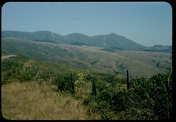
- Abstract:
- View north eastward from west shoulder of Mt Tamalpais
- Call Number:
- P08575
- Country:
- United States
- State/Province:
- California
- Alternate Identifier:
- 256.9
- Persistent URL:
- http://purl.dlib.indiana.edu/iudl/archives/cushman/P08575
-
- Description:
- 100 f 5.6 sl - 50mm
- Subject:
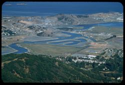
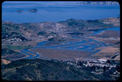
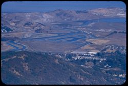
- Peninsulas, Sandbars, Hills, Bolinas Lagoon (Calif.), Bays (Bodies of water), Tamalpais, Mount (Calif.), Trees, Coastlines, and Seas
- Series:
- 2-56
- Creator:
- Cushman, Charles W., 1896-1972
- Date Created:
- 1956-03-14
- Genre:
- Landscape photographs
- Frame Number:
- 7
- County:
- Marin
- Abstract:
- Looking down on Bolinas Lagoon
- Call Number:
- P08573
- City:
- Bolinas
- Country:
- United States
- State/Province:
- California
- Alternate Identifier:
- 256.7
- Persistent URL:
- http://purl.dlib.indiana.edu/iudl/archives/cushman/P08573
-
- Description:
- 100 f 6.3 tl
- Subject:
- Sandbars, Hills, Bolinas Lagoon (Calif.), Bays (Bodies of water), Tamalpais, Mount (Calif.), Trees, Coastlines, and Seas
- Series:
- 2-56
- Creator:
- Cushman, Charles W., 1896-1972
- Date Created:
- 1956-03-14
- Genre:
- Landscape photographs
- Frame Number:
- 6
- County:
- Marin
- Abstract:
- Looking down on Bolinas Lagoon
- Call Number:
- P08572
- City:
- Bolinas
- Country:
- United States
- State/Province:
- California
- Alternate Identifier:
- 256.6
- Persistent URL:
- http://purl.dlib.indiana.edu/iudl/archives/cushman/P08572
-
- Description:
- 100 f 6.3 tl
- Subject:
- Bays (Bodies of water), Seas, Bolinas Lagoon (Calif.), Trees, Coastlines, Forests, Hills, Sandbars, and Tamalpais, Mount (Calif.)
- Series:
- 2-56
- Creator:
- Cushman, Charles W., 1896-1972
- Date Created:
- 1956-03-14
- Genre:
- Landscape photographs
- Frame Number:
- 5
- County:
- Marin
- Abstract:
- Looking down on Bolinas Lagoon
- Call Number:
- P08571
- City:
- Bolinas
- Country:
- United States
- State/Province:
- California
- Alternate Identifier:
- 256.5
- Persistent URL:
- http://purl.dlib.indiana.edu/iudl/archives/cushman/P08571
-
- Description:
- 100 f 8 tl
- Subject:
- Trees, Saint Helena, Mount (Calif.), Mountains, Tamalpais, Mount (Calif.), and Hills
- Series:
- 2-56
- Creator:
- Cushman, Charles W., 1896-1972
- Date Created:
- 1956-03-14
- Genre:
- Landscape photographs
- Frame Number:
- 4
- County:
- Marin
- Abstract:
- Distant view north - toward Mt. St. Helena noon
- Call Number:
- P08570
- Country:
- United States
- State/Province:
- California
- Alternate Identifier:
- 256.4
- Persistent URL:
- http://purl.dlib.indiana.edu/iudl/archives/cushman/P08570
-
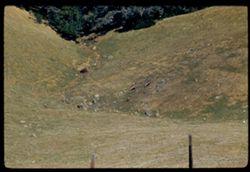
- Description:
- 100 f 6.3 tl
- Subject:
- Valleys, Deer, and Tamalpais, Mount (Calif.)
- Series:
- 2-56
- Creator:
- Cushman, Charles W., 1896-1972
- Date Created:
- 1956-03-14
- Frame Number:
- 3
- County:
- Marin
- Abstract:
- 3 Deer below
- Call Number:
- P08569
- Country:
- United States
- State/Province:
- California
- Alternate Identifier:
- 256.3
- Persistent URL:
- http://purl.dlib.indiana.edu/iudl/archives/cushman/P08569
-
- Description:
- 100 f 6.3 tl
- Subject:
- Hills, Mountains, Tamalpais, Mount (Calif.), and Trees
- Series:
- 2-56
- Creator:
- Cushman, Charles W., 1896-1972
- Date Created:
- 1956-03-14
- Genre:
- Landscape photographs
- Frame Number:
- 2
- County:
- Marin
- Abstract:
- From road on West shoulder of Mt. Tamalpais: Folded hills to north
- Call Number:
- P08568
- Country:
- United States
- State/Province:
- California
- Alternate Identifier:
- 256.2
- Persistent URL:
- http://purl.dlib.indiana.edu/iudl/archives/cushman/P08568
-
- Description:
- 100 f 5.6 tl
- Subject:
- Bays (Bodies of water), Seas, Bolinas Lagoon (Calif.), Coastlines, Bolinas Bay (Calif.), Cities & towns, Land, Forests, Sandbars, Firs, and Tamalpais, Mo...
- Series:
- 29-55
- Creator:
- Cushman, Charles W., 1896-1972
- Date Created:
- 1955-11-06
- Genre:
- Landscape photographs
- Frame Number:
- 16
- Street Address:
- Ridgecrest Road
- County:
- Marin
- Abstract:
- Bolinas Bay from Ridgecrest Rd
- Call Number:
- P08507
- City:
- Bolinas
- Country:
- United States
- State/Province:
- California
- Alternate Identifier:
- 2955.16
- Persistent URL:
- http://purl.dlib.indiana.edu/iudl/archives/cushman/P08507
-
- Description:
- 100 f 5.6 tl
- Subject:
- Bolinas Lagoon (Calif.), Bays (Bodies of water), Tamalpais, Mount (Calif.), Land, Coastlines, and Trees
- Series:
- 29-55
- Creator:
- Cushman, Charles W., 1896-1972
- Date Created:
- 1955-11-06
- Genre:
- Landscape photographs
- Frame Number:
- 15
- Street Address:
- Ridgecrest Road
- County:
- Marin
- Abstract:
- Bolinas Lagoon at low tide from Ridgecrest road high above on east
- Call Number:
- P08506
- Country:
- United States
- State/Province:
- California
- Alternate Identifier:
- 2955.15
- Persistent URL:
- http://purl.dlib.indiana.edu/iudl/archives/cushman/P08506
-
- Description:
- 100 f 5.6 tl
- Subject:
- Bays (Bodies of water), Richmond-San Rafael Bridge, Bridge construction, Cities & towns, Buildings, Bridges, Islands, Tamalpais, Mount (Calif.), Hills, a...
- Series:
- 29-55
- Creator:
- Cushman, Charles W., 1896-1972
- Date Created:
- 1955-10-31
- Genre:
- Landscape photographs and Cityscape photographs
- Frame Number:
- 13
- County:
- Marin
- Abstract:
- New bridge - SR to Richmond again
- Call Number:
- P08504
- Country:
- United States
- State/Province:
- California
- Alternate Identifier:
- 2955.13
- Persistent URL:
- http://purl.dlib.indiana.edu/iudl/archives/cushman/P08504
-
- Description:
- 100 f 5.6 tl
- Subject:
- Bays (Bodies of water), Angel Island (Calif.), Trees, Mountains, Islands, Tamalpais, Mount (Calif.), Hills, and Cities & towns
- Series:
- 29-55
- Creator:
- Cushman, Charles W., 1896-1972
- Date Created:
- 1955-10-31
- Genre:
- Landscape photographs and Cityscape photographs
- Frame Number:
- 12
- County:
- Marin
- Abstract:
- Toward Angel Island & Belvidere
- Call Number:
- P08503
- City:
- Belvedere
- Country:
- United States
- State/Province:
- California
- Alternate Identifier:
- 2955.12
- Persistent URL:
- http://purl.dlib.indiana.edu/iudl/archives/cushman/P08503
-
- Description:
- 100 f 6.3 tl
- Subject:
- Cities & towns, Hills, Roads, Mountains, Tamalpais, Mount (Calif.), Shadows, San Bruno Mountain (Calif.), and Bays (Bodies of water)
- Series:
- 29-55
- Creator:
- Cushman, Charles W., 1896-1972
- Date Created:
- 1955-10-31
- Genre:
- Landscape photographs and Cityscape photographs
- Frame Number:
- 10
- County:
- Marin and San Francisco
- Abstract:
- Toward SE - to San Bruno Mtn
- Call Number:
- P08501
- City:
- San Francisco
- Country:
- United States
- State/Province:
- California
- Alternate Identifier:
- 2955.10
- Persistent URL:
- http://purl.dlib.indiana.edu/iudl/archives/cushman/P08501
-
- Description:
- 100 f 6.3 tl
- Subject:
- Bays (Bodies of water), Seas, Trees, Cities & towns, Richardson Bay (Calif.), Peninsulas, Bridges, Tamalpais, Mount (Calif.), San Francisco Bay (Calif.),...
- Series:
- 29-55
- Creator:
- Cushman, Charles W., 1896-1972
- Date Created:
- 1955-10-31
- Genre:
- Landscape photographs and Cityscape photographs
- Frame Number:
- 11
- County:
- Marin and San Francisco
- Abstract:
- Richardson Bay Bridge
- Call Number:
- P08502
- City:
- San Francisco
- Country:
- United States
- State/Province:
- California
- Alternate Identifier:
- 2955.11
- Persistent URL:
- http://purl.dlib.indiana.edu/iudl/archives/cushman/P08502
-
- Description:
- 100 f 5.6 tl
- Subject:
- Bays (Bodies of water), Richardson Bay Bridge (Calif.), Skyscrapers, Cities & towns, Buildings, Bridges, Tamalpais, Mount (Calif.), Hills, San Francisco ...
- Series:
- 29-55
- Creator:
- Cushman, Charles W., 1896-1972
- Date Created:
- 1955-10-31
- Genre:
- Landscape photographs and Cityscape photographs
- Frame Number:
- 9
- County:
- Marin and San Francisco
- Abstract:
- Toward Sausalito & SF
- Call Number:
- P08500
- City:
- Sausalito and San Francisco
- Country:
- United States
- State/Province:
- California
- Alternate Identifier:
- 2955.9
- Persistent URL:
- http://purl.dlib.indiana.edu/iudl/archives/cushman/P08500
-
- Description:
- 100 f 6.3 tl
- Subject:
- Bays (Bodies of water), Trees, Cities & towns, Islands, Tamalpais, Mount (Calif.), Hills, Streams, Canals, and Corte Madera Creek (Marin County, Calif.)
- Series:
- 29-55
- Creator:
- Cushman, Charles W., 1896-1972
- Date Created:
- 1955-10-31
- Genre:
- Landscape photographs and Cityscape photographs
- Frame Number:
- 8
- County:
- Marin
- Abstract:
- Canals (?)
- Call Number:
- P08499
- Country:
- United States
- State/Province:
- California
- Alternate Identifier:
- 2955.8
- Persistent URL:
- http://purl.dlib.indiana.edu/iudl/archives/cushman/P08499
-
- Description:
- 100 f 6.3 tl
- Subject:
- Bays (Bodies of water), Richmond-San Rafael Bridge, Bridge construction, Cities & towns, Bridges, Tamalpais, Mount (Calif.), and Hills
- Series:
- 29-55
- Creator:
- Cushman, Charles W., 1896-1972
- Date Created:
- 1955-10-31
- Genre:
- Cityscape photographs
- Frame Number:
- 7
- County:
- Marin
- Abstract:
- San Rafael - Richmond bridge under construction
- Call Number:
- P08498
- Country:
- United States
- State/Province:
- California
- Alternate Identifier:
- 2955.7
- Persistent URL:
- http://purl.dlib.indiana.edu/iudl/archives/cushman/P08498
-
- Description:
- 100 f 6.3 tl
- Subject:
- Richmond-San Rafael Bridge, Cities & towns, Haze, Bays (Bodies of water), Tamalpais, Mount (Calif.), and Construction
- Series:
- 28-55
- Creator:
- Cushman, Charles W., 1896-1972
- Date Created:
- 1955-10-12
- Genre:
- Cityscape photographs
- Frame Number:
- 22
- County:
- Marin
- Abstract:
- Richmond - San Rafael bridge abuilding - from Tamalpais in smoke haze
- Call Number:
- P08477
- City:
- San Rafael
- Country:
- United States
- State/Province:
- California
- Alternate Identifier:
- 2855.22
- Persistent URL:
- http://purl.dlib.indiana.edu/iudl/archives/cushman/P08477
-
- Description:
- 100 f 6.3 tl
- Subject:
- Oceans, Houses, Trees, Pacific Ocean, Mountains, and Tamalpais, Mount (Calif.)
- Series:
- 28-55
- Creator:
- Cushman, Charles W., 1896-1972
- Date Created:
- 1955-10-12
- Genre:
- Landscape photographs
- Frame Number:
- 21
- County:
- Marin
- Abstract:
- View down (E) from Tamalpais
- Call Number:
- P08476
- Country:
- United States
- State/Province:
- California
- Alternate Identifier:
- 2855.21
- Persistent URL:
- http://purl.dlib.indiana.edu/iudl/archives/cushman/P08476
-
- Description:
- 100 f 6.3 tl
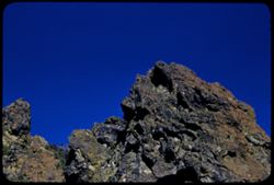
- Subject:
- Mountains, Rock formations, and Tamalpais, Mount (Calif.)
- Series:
- 28-55
- Creator:
- Cushman, Charles W., 1896-1972
- Date Created:
- 1955-10-12
- Genre:
- Landscape photographs
- Frame Number:
- 20
- County:
- Marin
- Abstract:
- Craggy rock near top of Mt. Tamalpais
- Call Number:
- P08475
- Country:
- United States
- State/Province:
- California
- Alternate Identifier:
- 2855.20
- Persistent URL:
- http://purl.dlib.indiana.edu/iudl/archives/cushman/P08475
-

- Description:
- 100 f 5.6 tl
- Subject:
- Bodies of water, Angel Island (Calif.), Trees, Coastlines, Streets, Mountains, Buildings, Shrubs, Clouds, Islands, Tamalpais, Mount (Calif.), Hills, and Dwel...
- Series:
- 5-55
- Creator:
- Cushman, Charles W., 1896-1972
- Date Created:
- 1955-03-10
- Genre:
- Landscape photographs
- Frame Number:
- 19
- Street Address:
- Tamalpais Road
- County:
- Marin
- Abstract:
- View ESE east from Tamalpais road toward Angel Island were out too far to left and had to be remounted
- Call Number:
- P07684
- City:
- Belvedere
- Country:
- United States
- State/Province:
- California
- Alternate Identifier:
- 555.19
- Persistent URL:
- http://purl.dlib.indiana.edu/iudl/archives/cushman/P07684
-
- Description:
- 100 f 5.6 tl
- Subject:
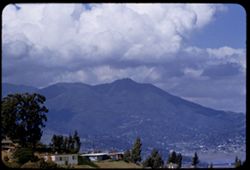
- Valleys, Hills, Bodies of water, Roads, Mountains, Tamalpais, Mount (Calif.), Trees, Buildings, Clouds, Dwellings, and Utility poles
- Series:
- 5-55
- Creator:
- Cushman, Charles W., 1896-1972
- Date Created:
- 1955-03-10
- Genre:
- Landscape photographs
- Frame Number:
- 4
- County:
- Marin
- Abstract:
- Cloud mass above Mt. Tamalpais from top of Sausalito All of frame will next to 3
- Call Number:
- P07669
- City:
- Sausalito
- Country:
- United States
- State/Province:
- California
- Alternate Identifier:
- 555.4
- Persistent URL:
- http://purl.dlib.indiana.edu/iudl/archives/cushman/P07669
-
- Description:
- 100 f 6 tl
- Subject:
- Valleys, Roads, Trees, Mountains, Buildings, Clouds, Tamalpais, Mount (Calif.), Hills, Utility poles, Fences, and Dwellings
- Series:
- 5-55
- Creator:
- Cushman, Charles W., 1896-1972
- Date Created:
- 1955-03-10
- Genre:
- Landscape photographs
- Frame Number:
- 3
- County:
- Marin
- Abstract:
- Cloud mass above Mt. Tamalpais from top of Sausalito
- Call Number:
- P07668
- City:
- Sausalito
- Country:
- United States
- State/Province:
- California
- Alternate Identifier:
- 555.3
- Persistent URL:
- http://purl.dlib.indiana.edu/iudl/archives/cushman/P07668
-
- Description:
- 50 f 9
- Subject:
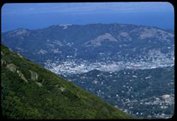
- San Quentin Bridge (Calif.), Bodies of water, Trees, Cities & towns, Buildings, Shrubs, Tamalpais, Mount (Calif.), Hills, and Mountains
- Series:
- 16-54
- Creator:
- Cushman, Charles W., 1896-1972
- Date Created:
- 1954-10-23
- Genre:
- Landscape photographs
- Frame Number:
- 3
- County:
- Marin
- Abstract:
- View east from Tamalpais down toward San Quentin + [?] bridge.
- Call Number:
- P07502
- Country:
- United States
- State/Province:
- California
- Physical Description:
- Anscochrome film.
- Alternate Identifier:
- 1654.3
- Persistent URL:
- http://purl.dlib.indiana.edu/iudl/archives/cushman/P07502
-
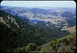
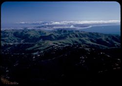
- Description:
- 50 f 9
- Subject:
- Valleys, Trees, Mountains, Shrubs, Lakes & ponds, and Tamalpais, Mount (Calif.)
- Series:
- 16-54
- Creator:
- Cushman, Charles W., 1896-1972
- Date Created:
- 1954-10-23
- Genre:
- Landscape photographs
- Frame Number:
- 2
- County:
- Marin
- Abstract:
- View NNW from top of Tamalpais.
- Call Number:
- P07501
- Country:
- United States
- State/Province:
- California
- Physical Description:
- Anscochrome film.
- Alternate Identifier:
- 1654.2
- Persistent URL:
- http://purl.dlib.indiana.edu/iudl/archives/cushman/P07501
-
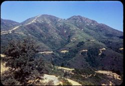
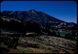
- Description:
- 50 f 8
- Subject:
- Trails & paths, Trees, Mountains, Shrubs, and Tamalpais, Mount (Calif.)
- Series:
- 16-54
- Creator:
- Cushman, Charles W., 1896-1972
- Date Created:
- 1954-10-23
- Genre:
- Landscape photographs
- Frame Number:
- 1
- County:
- Marin
- Abstract:
- Mt Tamalpais from SSW.
- Call Number:
- P07500
- Country:
- United States
- State/Province:
- California
- Physical Description:
- Anscochrome film.
- Alternate Identifier:
- 1654.1
- Persistent URL:
- http://purl.dlib.indiana.edu/iudl/archives/cushman/P07500
-
- Description:
- 50 f 8
- Subject:
- Wildflowers, Bays (Bodies of water), Richardson Bay Bridge (Calif.), Grasses, Trees, Mountains, Richardson Bay (Calif.), Shrubs, Tamalpais, Mount (Calif.), H...
- Series:
- 4-54
- Creator:
- Cushman, Charles W., 1896-1972
- Date Created:
- 1954-08-13
- Genre:
- Cityscape photographs
- Frame Number:
- 14
- Street Address:
- United States Highway 101
- County:
- Marin
- Abstract:
- Mt. Tamalpais from US101- Richardson Bay bridge
- Call Number:
- P07188
- Country:
- United States
- State/Province:
- California
- Physical Description:
- Anscochrome film.
- Alternate Identifier:
- 454.14
- Persistent URL:
- http://purl.dlib.indiana.edu/iudl/archives/cushman/P07188
-
- Description:
- 50 f 9
- Subject:
- Grasses, Grazing, Trees, Meadows, Mountains, Fences, Shrubs, and Tamalpais, Mount (Calif.)
- Series:
- 4-54
- Creator:
- Cushman, Charles W., 1896-1972
- Date Created:
- 1954-07-29
- Genre:
- Landscape photographs
- Frame Number:
- 10
- County:
- Marin
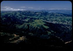
- Abstract:
- Tamalpais from SW.
- Call Number:
- P07184
- Country:
- United States
- State/Province:
- California
- Physical Description:
- Anscochrome film.
- Alternate Identifier:
- 454.10
- Persistent URL:
- http://purl.dlib.indiana.edu/iudl/archives/cushman/P07184
-
- Description:
- 25 f 5.6 Pola
- Subject:
- Lakes & ponds, Hills, Tamalpais, Mount (Calif.), Shadows, and Clouds
- Series:
- 12-52
- Creator:
- Cushman, Charles W., 1896-1972
- Date Created:
- 1952-03-30
- Genre:
- Landscape photographs
- Frame Number:
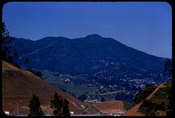
- 27
- County:
- Marin
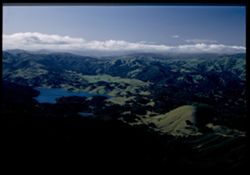
- Abstract:
- Marin hills north of Tamalpais
- Call Number:
- P05933
- Country:
- United States
- State/Province:
- California
- Physical Description:
- Image was originally mounted in a glass enclosure. Before digitization, the image was removed and placed in a Wess Plastic, Inc. brand, 2" x 2", pl...
- Alternate Identifier:
- 1252.27
- Persistent URL:
- http://purl.dlib.indiana.edu/iudl/archives/cushman/P05933
-
- Description:
- 25 f 6.3 Pola
- Subject:
- Tamalpais, Mount (Calif.) and Hills
- Series:
- 12-52
- Creator:
- Cushman, Charles W., 1896-1972
- Date Created:
- 1952-03-30
- Genre:
- Landscape photographs and Cityscape photographs
- Frame Number:
- 26
- County:
- Marin
- Abstract:
- Marin hills north of Tamalpais.
- Call Number:
- P05932
- Country:
- United States
- State/Province:
- California
- Alternate Identifier:
- 1252.26
- Persistent URL:
- http://purl.dlib.indiana.edu/iudl/archives/cushman/P05932
-
- Description:
- 25 f 8 Pola
- Subject:
- Bays (Bodies of water), Roads, Mountains, Tamalpais, Mount (Calif.), Hills, and San Francisco Bay (Calif.)
- Series:
- 12-52
- Creator:
- Cushman, Charles W., 1896-1972
- Date Created:
- 1952-03-30
- Genre:
- Landscape photographs and Cityscape photographs
- Frame Number:
- 23
- County:
- Marin
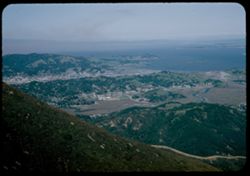
- Abstract:
- View N by E over San Rafael.
- Call Number:
- P05930
- City:
- San Rafael
- Country:
- United States
- State/Province:
- California
- Alternate Identifier:
- 1252.23
- Persistent URL:
- http://purl.dlib.indiana.edu/iudl/archives/cushman/P05930
-
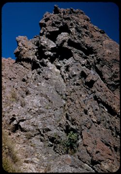
- Description:
- 25 f 9
- Subject:
- Rock formations, Tamalpais, Mount (Calif.), and Shrubs
- Series:
- 12-52
- Creator:
- Cushman, Charles W., 1896-1972
- Date Created:
- 1952-03-30
- Genre:
- Landscape photographs
- Frame Number:
- 20
- County:
- Marin
- Abstract:
- Close-up of 19 [Cinder-like rock atop Mt. Tamalpais.]
- Call Number:
- P05927
- Country:
- United States
- State/Province:
- California
- Alternate Identifier:
- 1252.20
- Persistent URL:
- http://purl.dlib.indiana.edu/iudl/archives/cushman/P05927
-
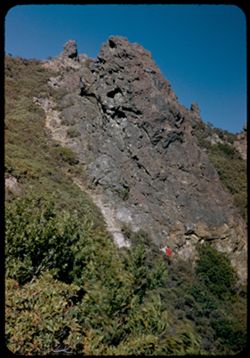
- Description:
- 25 f 9
- Subject:
- Hiking, Cliffs, People, Shrubs, Rock formations, and Tamalpais, Mount (Calif.)
- Series:
- 12-52
- Creator:
- Cushman, Charles W., 1896-1972
- Date Created:
- 1952-03-30
- Genre:
- Landscape photographs
- Frame Number:
- 19
- County:
- Marin
- Abstract:
- Cinder-like rock atop Mt. Tamalpais.
- Call Number:
- P05926
- Country:
- United States
- State/Province:
- California
- Alternate Identifier:
- 1252.19
- Persistent URL:
- http://purl.dlib.indiana.edu/iudl/archives/cushman/P05926
-
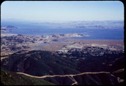
- Description:
- 25 f 6.3 Pola
- Subject:
- Bays (Bodies of water), Oceans, Fog, Trees, Coastlines, Pacific Ocean, Pacific Coast (Calif.), Tamalpais, Mount (Calif.), Hills, San Francisco Bay (Calif.), ...
- Series:
- 12-52
- Creator:
- Cushman, Charles W., 1896-1972
- Date Created:
- 1952-03-30
- Genre:
- Landscape photographs and Cityscape photographs
- Frame Number:
- 18
- County:
- Marin and San Francisco
- Abstract:
- Fog bank over SF.
- Call Number:
- P05925
- City:
- San Francisco
- Country:
- United States
- State/Province:
- California
- Alternate Identifier:
- 1252.18
- Persistent URL:
- http://purl.dlib.indiana.edu/iudl/archives/cushman/P05925
-
- Description:
- 25 f 6 Pola
- Subject:
- Bays (Bodies of water), Oceans, Coastlines, Pacific Ocean, Shrubs, Pacific Coast (Calif.), Tamalpais, Mount (Calif.), Hills, and San Francisco Bay (Calif.)
- Series:
- 12-52
- Creator:
- Cushman, Charles W., 1896-1972
- Date Created:
- 1952-03-30
- Genre:
- Landscape photographs and Cityscape photographs
- Frame Number:
- 17
- County:
- Marin and San Francisco
- Abstract:
- SF beyond Marin hills.
- Call Number:
- P05924
- City:
- San Francisco
- Country:
- United States
- State/Province:
- California
- Alternate Identifier:
- 1252.17
- Persistent URL:
- http://purl.dlib.indiana.edu/iudl/archives/cushman/P05924
-
- Description:
- 25 f 6.3 Pola
- Subject:
- Hills, San Francisco Bay (Calif.), Pacific Ocean, Bays (Bodies of water), Pacific Coast (Calif.), Tamalpais, Mount (Calif.), Trees, Oceans, Coastlines, and C...
- Series:
- 12-52
- Creator:
- Cushman, Charles W., 1896-1972
- Date Created:
- 1952-03-30
- Genre:
- Landscape photographs and Cityscape photographs
- Frame Number:
- 16
- County:
- Marin and San Francisco
- Abstract:
- S.F. west end.
- Call Number:
- P05923
- City:
- San Francisco
- Country:
- United States
- State/Province:
- California
- Alternate Identifier:
- 1252.16
- Persistent URL:
- http://purl.dlib.indiana.edu/iudl/archives/cushman/P05923
-
- Description:
- 25 f 6.3 Pola
- Subject:
- Wildflowers, Grasses, Roads, Trees, Mountains, Shrubs, Tamalpais, Mount (Calif.), Utility poles, and Houses
- Series:
- 12-52
- Creator:
- Cushman, Charles W., 1896-1972
- Date Created:
- 1952-03-30
- Genre:
- Landscape photographs
- Frame Number:
- 15
- County:
- Marin
- Abstract:
- Mt. Tamalpais from road above Mill Valley.
- Call Number:
- P05922
- City:
- Mill Valley
- Country:
- United States
- State/Province:
- California
- Alternate Identifier:
- 1252.15
- Persistent URL:
- http://purl.dlib.indiana.edu/iudl/archives/cushman/P05922