
Search Constraints
You searched for:
Campus
IUB
Remove constraint Campus: IUB
County
Mono
Remove constraint County: Mono
« Previous |
1 - 100 of 102
|
Next »
Search Results
-
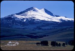
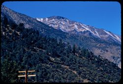
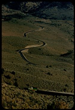
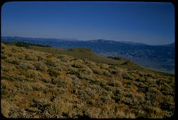
- Description:
- 100 f 8 tl
- Subject:
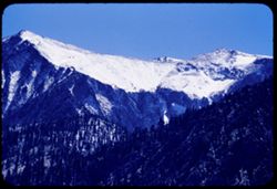
- Snow, Valleys, Trees, Conway Summit (Calif.), Mountains, and Dunderberg Peak (Calif.)
- Series:
- 28-55
- Creator:
- Cushman, Charles W., 1896-1972
- Date Created:
- 1955-09-26
- Genre:
- Landscape photographs
- Frame Number:
- 1
- Street Address:
- United States Highway 395
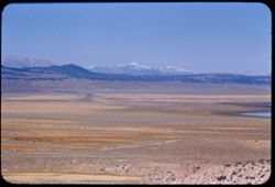
- County:
- Mono
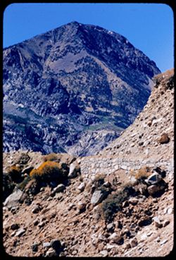
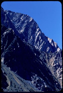
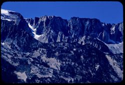
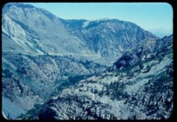
- Abstract:
- West from just below Conway Summit toward The Thundese ? and West from just below Conway Summit toward (?) Dunderberg Pk.(?)
- Call Number:
- P08458
- Country:
- United States
- State/Province:
- California
- Alternate Identifier:
- 2855.1
- Persistent URL:
- http://purl.dlib.indiana.edu/iudl/archives/cushman/P08458
- Holding Location:
- Bloomington - University Archives
Wells Library E460
1320 E 10th St.
Bloomington, IN 47405
Contact at archives@indiana.edu, 812-855-1127
-
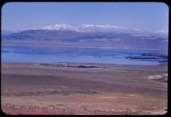
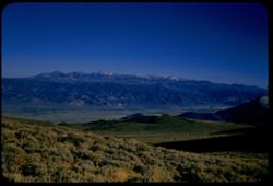
- Description:
- 100 f 8 tl
- Subject:
- White Mountains (Calif. and Nev.), Mountains, Lakes & ponds, Land, Waterfronts, Mono Lake (Calif.), and Reflections
- Series:
- 27-55
- Creator:
- Cushman, Charles W., 1896-1972
- Date Created:
- 1955-09-26
- Genre:
- Landscape photographs
- Frame Number:
- 37
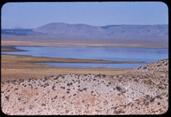
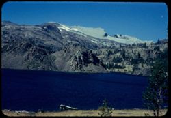
- County:
- Mono
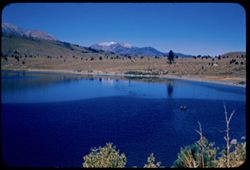
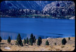
- Abstract:
- Mono Lake - White Mtns. in distance
- Call Number:
- P08456
- Country:
- United States
- State/Province:
- California
- Alternate Identifier:
- 2755.37
- Persistent URL:
- http://purl.dlib.indiana.edu/iudl/archives/cushman/P08456
- Holding Location:
- Bloomington - University Archives
Wells Library E460
1320 E 10th St.
Bloomington, IN 47405
Contact at archives@indiana.edu, 812-855-1127
-
- Description:
- 100 f 8 tl
- Subject:
- Sonora Pass (Calif.), Conway Summit (Calif.), Mountains, and Land
- Series:
- 28-55
- Creator:
- Cushman, Charles W., 1896-1972
- Date Created:
- 1955-09-26
- Genre:
- Landscape photographs
- Frame Number:
- 0
- Street Address:
- United States Highway 395
- County:
- Mono
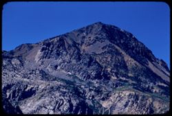
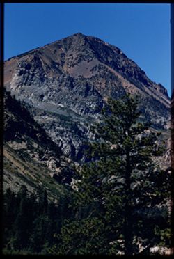
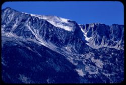
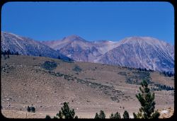
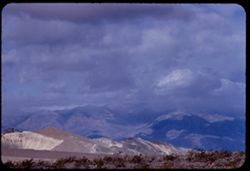
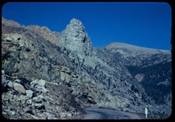
- Abstract:
- Toward Sonora Peak from just below Conway Summit at 8000 ft. and Toward Sonora Pk from just below Conway Summit 8000 ft.
- Call Number:
- P08457
- Country:
- United States
- State/Province:
- California
- Alternate Identifier:
- 2855.0
- Persistent URL:
- http://purl.dlib.indiana.edu/iudl/archives/cushman/P08457
- Holding Location:
- Bloomington - University Archives
Wells Library E460
1320 E 10th St.
Bloomington, IN 47405
Contact at archives@indiana.edu, 812-855-1127
-
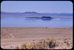
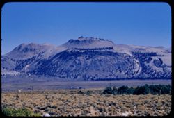
- Description:
- 100 f 6.3 tl
- Subject:
- Trees, Lakes & ponds, Mounds (Landforms), Islands, Mono Lake (Calif.), and Reflections
- Series:
- 27-55
- Creator:
- Cushman, Charles W., 1896-1972
- Date Created:
- 1955-09-26
- Genre:
- Landscape photographs
- Frame Number:
- 36
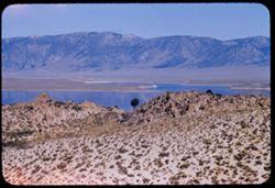
- County:
- Mono
- Abstract:
- Strange domes south of Mono Lake
- Call Number:
- P08455
- Country:
- United States
- State/Province:
- California
- Alternate Identifier:
- 2755.36
- Persistent URL:
- http://purl.dlib.indiana.edu/iudl/archives/cushman/P08455
- Holding Location:
- Bloomington - University Archives
Wells Library E460
1320 E 10th St.
Bloomington, IN 47405
Contact at archives@indiana.edu, 812-855-1127
-
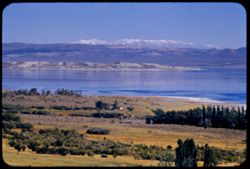
- Description:
- 100 f 8 tl
- Subject:
- Snow, Grasses, White Mountains (Calif. and Nev.), Trees, Mountains, Lakes & ponds, Waterfronts, Islands, Reflections, and Mono Lake (Calif.)
- Series:
- 27-55
- Creator:
- Cushman, Charles W., 1896-1972
- Date Created:
- 1955-09-26
- Genre:
- Landscape photographs
- Frame Number:
- 35
- County:
- Mono
- Abstract:
- Snow-colored White Mtns beyond Mono Lake
- Call Number:
- P08454
- Country:
- United States
- State/Province:
- California
- Alternate Identifier:
- 2755.35
- Persistent URL:
- http://purl.dlib.indiana.edu/iudl/archives/cushman/P08454
- Holding Location:
- Bloomington - University Archives
Wells Library E460
1320 E 10th St.
Bloomington, IN 47405
Contact at archives@indiana.edu, 812-855-1127
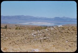
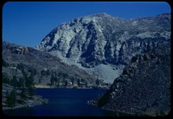
-
- Description:
- 100 f 8 tl
- Subject:
- Lakes & ponds, Mono Lake (Calif.), Mountains, Waterfronts, Plants, and Islands
- Series:
- 27-55
- Creator:
- Cushman, Charles W., 1896-1972
- Date Created:
- 1955-09-26
- Genre:
- Landscape photographs
- Frame Number:
- 34
- County:
- Mono
- Abstract:
- Island in Mono L.
- Call Number:
- P08453
- Country:
- United States
- State/Province:
- California
- Alternate Identifier:
- 2755.34
- Persistent URL:
- http://purl.dlib.indiana.edu/iudl/archives/cushman/P08453
- Holding Location:
- Bloomington - University Archives
Wells Library E460
1320 E 10th St.
Bloomington, IN 47405
Contact at archives@indiana.edu, 812-855-1127
-
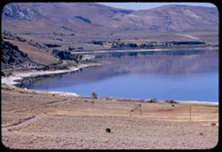
- Description:
- 100 f 6.3 tl
- Subject:
- Lakes & ponds, Reflections, Roads, Mountains, Waterfronts, Utility poles, Trees, and Mono Lake (Calif.)
- Series:
- 27-55
- Creator:
- Cushman, Charles W., 1896-1972
- Date Created:
- 1955-09-26
- Genre:
- Landscape photographs
- Frame Number:
- 33
- County:
- Mono
- Abstract:
- West end of Mono Lake
- Call Number:
- P08452
- Country:
- United States
- State/Province:
- California
- Alternate Identifier:
- 2755.33
- Persistent URL:
- http://purl.dlib.indiana.edu/iudl/archives/cushman/P08452
- Holding Location:
- Bloomington - University Archives
Wells Library E460
1320 E 10th St.
Bloomington, IN 47405
Contact at archives@indiana.edu, 812-855-1127
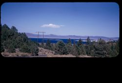
-
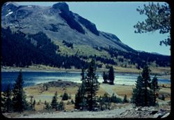
- Description:
- 100 f 8 tl
- Subject:
- Electric lines, Roads, Trees, Mountains, Lakes & ponds, Islands, Utility poles, Reflections, Plants, and Mono Lake (Calif.)
- Series:
- 27-55
- Creator:
- Cushman, Charles W., 1896-1972
- Date Created:
- 1955-09-26
- Genre:
- Landscape photographs
- Frame Number:
- 32
- Street Address:
- Tioga Pass Road
- County:
- Mono
- Abstract:
- Mono Lake from Tioga Pass road
- Call Number:
- P08451
- Country:
- United States
- State/Province:
- California
- Alternate Identifier:
- 2755.32
- Persistent URL:
- http://purl.dlib.indiana.edu/iudl/archives/cushman/P08451
- Holding Location:
- Bloomington - University Archives
Wells Library E460
1320 E 10th St.
Bloomington, IN 47405
Contact at archives@indiana.edu, 812-855-1127
-
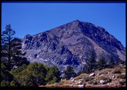
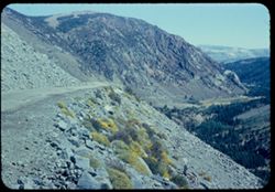
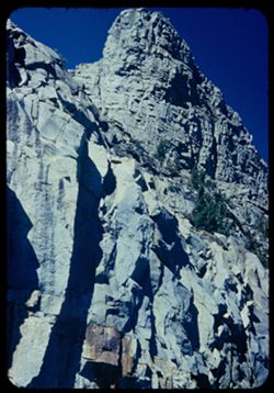
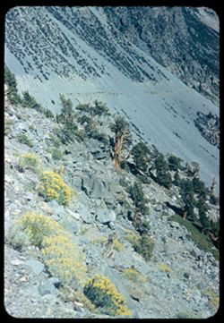
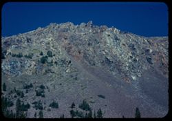
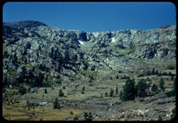
- Description:
- 100 f 5.6 tl
- Subject:
- Rocks, Trees, Tioga Peak (Calif.), Mountains, and Plants
- Series:
- 27-55
- Creator:
- Cushman, Charles W., 1896-1972
- Date Created:
- 1955-09-26
- Genre:
- Landscape photographs
- Frame Number:
- 30
- County:
- Mono
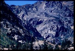
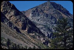
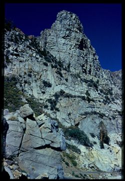
- Abstract:
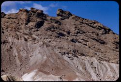
- Toward Tioga Pk & granite comb
- Call Number:
- P08449
- Country:
- United States
- State/Province:
- California
- Physical Description:
- Image was originally mounted in a glass enclosure. Before digitization, the image was removed and placed in a Wess Plastic, Inc. brand, 2" x 2", pl...
- Alternate Identifier:
- 2755.30
- Persistent URL:
- http://purl.dlib.indiana.edu/iudl/archives/cushman/P08449
- Holding Location:
- Bloomington - University Archives
Wells Library E460
1320 E 10th St.
Bloomington, IN 47405
Contact at archives@indiana.edu, 812-855-1127
-
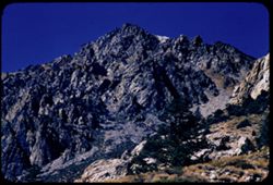
- Description:
- 100 f 8 tl
- Subject:
- Rocks, Trees, Tioga Peak (Calif.), Mountains, and Rock formations
- Series:
- 27-55
- Creator:
- Cushman, Charles W., 1896-1972
- Date Created:
- 1955-09-26
- Genre:
- Landscape photographs
- Frame Number:
- 31
- County:
- Mono
- Abstract:
- Up at top of peak north of Tioga
- Call Number:
- P08450
- Country:
- United States
- State/Province:
- California
- Alternate Identifier:
- 2755.31
- Persistent URL:
- http://purl.dlib.indiana.edu/iudl/archives/cushman/P08450
- Holding Location:
- Bloomington - University Archives
Wells Library E460
1320 E 10th St.
Bloomington, IN 47405
Contact at archives@indiana.edu, 812-855-1127
-
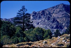
- Description:
- 100 f 5.6 tl
- Subject:
- Rocks, Trees, Tioga Peak (Calif.), Tioga Pass (Calif.), Mountains, and Plants
- Series:
- 27-55
- Creator:
- Cushman, Charles W., 1896-1972
- Date Created:
- 1955-09-26
- Genre:
- Landscape photographs
- Frame Number:
- 29
- County:
- Mono
- Abstract:
- Toward Tioga Pk & granite comb
- Call Number:
- P08448
- Country:
- United States
- State/Province:
- California
- Alternate Identifier:
- 2755.29
- Persistent URL:
- http://purl.dlib.indiana.edu/iudl/archives/cushman/P08448
- Holding Location:
- Bloomington - University Archives
Wells Library E460
1320 E 10th St.
Bloomington, IN 47405
Contact at archives@indiana.edu, 812-855-1127
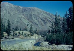
-
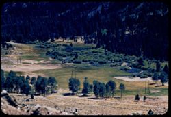
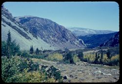
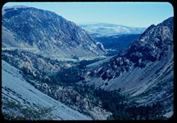
- Description:
- 100 f 6.3 tl
- Subject:
- Valleys, Dirt roads, Trees, Meadows, Lee Vining Creek (Calif.), Utility poles, and Streams
- Series:
- 27-55
- Creator:
- Cushman, Charles W., 1896-1972
- Date Created:
- 1955-09-26
- Genre:
- Landscape photographs
- Frame Number:
- 28
- County:
- Mono
- Abstract:
- Valley of Leevining Creek
- Call Number:
- P08447
- Country:
- United States
- State/Province:
- California
- Alternate Identifier:
- 2755.28
- Persistent URL:
- http://purl.dlib.indiana.edu/iudl/archives/cushman/P08447
- Holding Location:
- Bloomington - University Archives
Wells Library E460
1320 E 10th St.
Bloomington, IN 47405
Contact at archives@indiana.edu, 812-855-1127
-
- Description:
- 100 f 6.3 tl
- Subject:
- Rocks, Tioga Peak (Calif.), Mountains, and Plants
- Series:
- 27-55
- Creator:
- Cushman, Charles W., 1896-1972
- Date Created:
- 1955-09-26
- Genre:
- Landscape photographs
- Frame Number:
- 27
- County:
- Mono
- Abstract:
- Toward Tioga Pk
- Call Number:
- P08446
- Country:
- United States
- State/Province:
- California
- Alternate Identifier:
- 2755.27
- Persistent URL:
- http://purl.dlib.indiana.edu/iudl/archives/cushman/P08446
- Holding Location:
- Bloomington - University Archives
Wells Library E460
1320 E 10th St.
Bloomington, IN 47405
Contact at archives@indiana.edu, 812-855-1127
-
- Description:
- 100 f 6.3 tl
- Subject:
- Dana Plateau (Calif.), Mountains, Snow, Trees, Tioga Pass (Calif.), and Mesas
- Series:
- 27-55
- Creator:
- Cushman, Charles W., 1896-1972
- Date Created:
- 1955-09-26
- Genre:
- Landscape photographs
- Frame Number:
- 26
- County:
- Mono
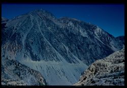
- Abstract:
- Snow on Dana Plateau
- Call Number:
- P08445
- Country:
- United States
- State/Province:
- California
- Alternate Identifier:
- 2755.26
- Persistent URL:
- http://purl.dlib.indiana.edu/iudl/archives/cushman/P08445
- Holding Location:
- Bloomington - University Archives
Wells Library E460
1320 E 10th St.
Bloomington, IN 47405
Contact at archives@indiana.edu, 812-855-1127
-
- Description:
- 100 f 8 tl
- Subject:
- Tioga Peak (Calif.) and Mountains
- Series:
- 27-55
- Creator:
- Cushman, Charles W., 1896-1972
- Date Created:
- 1955-09-26
- Genre:
- Landscape photographs
- Frame Number:
- 25
- County:
- Mono
- Abstract:
- Tioga Pk
- Call Number:
- P08444
- Country:
- United States
- State/Province:
- California
- Alternate Identifier:
- 2755.25
- Persistent URL:
- http://purl.dlib.indiana.edu/iudl/archives/cushman/P08444
- Holding Location:
- Bloomington - University Archives
Wells Library E460
1320 E 10th St.
Bloomington, IN 47405
Contact at archives@indiana.edu, 812-855-1127
-
- Description:
- 100 f 8 tl
- Subject:
- Trees, Tioga Peak (Calif.), Mountains, and Rock formations
- Series:
- 27-55
- Creator:
- Cushman, Charles W., 1896-1972
- Date Created:
- 1955-09-26
- Genre:
- Landscape photographs
- Frame Number:
- 24
- County:
- Mono
- Abstract:
- Granite mass below tioga Pk
- Call Number:
- P08443
- Country:
- United States
- State/Province:
- California
- Physical Description:
- Image was originally mounted in a glass enclosure. Before digitization, the image was removed and placed in a Wess Plastic, Inc. brand, 2" x 2", pl...
- Alternate Identifier:
- 2755.24
- Persistent URL:
- http://purl.dlib.indiana.edu/iudl/archives/cushman/P08443
- Holding Location:
- Bloomington - University Archives
Wells Library E460
1320 E 10th St.
Bloomington, IN 47405
Contact at archives@indiana.edu, 812-855-1127
-
- Description:
- 100 f 8 tl
- Subject:
- Dana Plateau (Calif.), Mesas, Lee Vining Creek (Calif.), Mountains, and Rock formations
- Series:
- 27-55
- Creator:
- Cushman, Charles W., 1896-1972
- Date Created:
- 1955-09-26
- Genre:
- Landscape photographs
- Frame Number:
- 23
- County:
- Mono
- Abstract:
- Granite comb at side of Dana Plateau
- Call Number:
- P08442
- Country:
- United States
- State/Province:
- California
- Alternate Identifier:
- 2755.23
- Persistent URL:
- http://purl.dlib.indiana.edu/iudl/archives/cushman/P08442
- Holding Location:
- Bloomington - University Archives
Wells Library E460
1320 E 10th St.
Bloomington, IN 47405
Contact at archives@indiana.edu, 812-855-1127
-
- Description:
- 100 f 9 tl tel lens
- Subject:
- Tioga Peak (Calif.), Mountains, Pines, and Rock formations
- Series:
- 27-55
- Creator:
- Cushman, Charles W., 1896-1972
- Date Created:
- 1955-09-26
- Genre:
- Landscape photographs
- Frame Number:
- 22
- County:
- Mono
- Abstract:
- Tioga Pk [P]
- Call Number:
- P08441
- Country:
- United States
- State/Province:
- California
- Physical Description:
- Image was originally mounted in a glass enclosure. Before digitization, the image was removed and placed in a Wess Plastic, Inc. brand, 2" x 2", pl...
- Alternate Identifier:
- 2755.22
- Persistent URL:
- http://purl.dlib.indiana.edu/iudl/archives/cushman/P08441
- Holding Location:
- Bloomington - University Archives
Wells Library E460
1320 E 10th St.
Bloomington, IN 47405
Contact at archives@indiana.edu, 812-855-1127
-
- Description:
- 100 f 8 tl
- Subject:
- Tioga Peak (Calif.), Mountains, Pines, and Rock formations
- Series:
- 27-55
- Creator:
- Cushman, Charles W., 1896-1972
- Date Created:
- 1955-09-26
- Genre:
- Landscape photographs
- Frame Number:
- 21
- County:
- Mono
- Abstract:
- Granite comb below Tioga Pk.
- Call Number:
- P08440
- Country:
- United States
- State/Province:
- California
- Alternate Identifier:
- 2755.21
- Persistent URL:
- http://purl.dlib.indiana.edu/iudl/archives/cushman/P08440
- Holding Location:
- Bloomington - University Archives
Wells Library E460
1320 E 10th St.
Bloomington, IN 47405
Contact at archives@indiana.edu, 812-855-1127
-
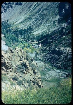
- Description:
- 100 f 8 tl
- Subject:
- Canyons, Trees, Lee Vining Creek (Calif.), and Mountains
- Series:
- 27-55
- Creator:
- Cushman, Charles W., 1896-1972
- Date Created:
- 1955-09-26
- Genre:
- Landscape photographs
- Frame Number:
- 19
- County:
- Mono
- Abstract:
- View of Leevining creek canyon
- Call Number:
- P08439
- Country:
- United States
- State/Province:
- California
- Alternate Identifier:
- 2755.19
- Persistent URL:
- http://purl.dlib.indiana.edu/iudl/archives/cushman/P08439
- Holding Location:
- Bloomington - University Archives
Wells Library E460
1320 E 10th St.
Bloomington, IN 47405
Contact at archives@indiana.edu, 812-855-1127
-
- Description:
- 100 f 8 tl
- Subject:
- Snow, Dana Plateau (Calif.), Mesas, Rock formations, Hills, and Trees
- Series:
- 27-55
- Creator:
- Cushman, Charles W., 1896-1972
- Date Created:
- 1955-09-26
- Genre:
- Landscape photographs
- Frame Number:
- 18
- Street Address:
- Leevining Creek Road
- County:
- Mono
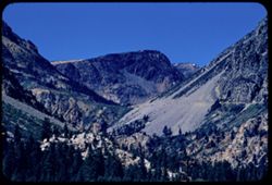
- Abstract:
- View up toward east wall of Dana Plateau from Leevining creek road
- Call Number:
- P08438
- Country:
- United States
- State/Province:
- California
- Alternate Identifier:
- 2755.18
- Persistent URL:
- http://purl.dlib.indiana.edu/iudl/archives/cushman/P08438
- Holding Location:
- Bloomington - University Archives
Wells Library E460
1320 E 10th St.
Bloomington, IN 47405
Contact at archives@indiana.edu, 812-855-1127
-
- Description:
- 100 f 8 tl
- Subject:
- Dana Plateau (Calif.), Snow, Trees, Rock formations, and Mesas
- Series:
- 27-55
- Creator:
- Cushman, Charles W., 1896-1972
- Date Created:
- 1955-09-26
- Genre:
- Landscape photographs
- Frame Number:
- 17
- Street Address:
- Leevining Creek Road
- County:
- Mono
- Abstract:
- View up toward east wall of Dana Plateau from Leevining creek road
- Call Number:
- P08437
- Country:
- United States
- State/Province:
- California
- Alternate Identifier:
- 2755.17
- Persistent URL:
- http://purl.dlib.indiana.edu/iudl/archives/cushman/P08437
- Holding Location:
- Bloomington - University Archives
Wells Library E460
1320 E 10th St.
Bloomington, IN 47405
Contact at archives@indiana.edu, 812-855-1127
-
- Description:
- 100 f 8 tl
- Subject:
- Birds, Animal behavior, Flying, and Mono Lake (Calif.)
- Series:
- 27-55
- Creator:
- Cushman, Charles W., 1896-1972
- Date Created:
- 1955-09-26
- Genre:
- Views
- Frame Number:
- 16
- County:
- Mono
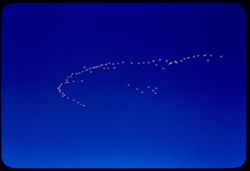
- Abstract:
- Flight of birds 70,333 miles
- Call Number:
- P08436
- Country:
- United States
- State/Province:
- California
- Alternate Identifier:
- 2755.16
- Persistent URL:
- http://purl.dlib.indiana.edu/iudl/archives/cushman/P08436
- Holding Location:
- Bloomington - University Archives
Wells Library E460
1320 E 10th St.
Bloomington, IN 47405
Contact at archives@indiana.edu, 812-855-1127
-
- Description:
- 100 f 8 tl
- Subject:
- Tioga Peak (Calif.), Hills, Mountains, and Trees
- Series:
- 27-55
- Creator:
- Cushman, Charles W., 1896-1972
- Date Created:
- 1955-09-26
- Genre:
- Landscape photographs
- Frame Number:
- 15
- Street Address:
- United States Highway 395
- County:
- Mono
- Abstract:
- Toward Tioga from US395 - 5 mi so. of Leevining
- Call Number:
- P08435
- City:
- Lee Vining
- Country:
- United States
- State/Province:
- California
- Alternate Identifier:
- 2755.15
- Persistent URL:
- http://purl.dlib.indiana.edu/iudl/archives/cushman/P08435
- Holding Location:
- Bloomington - University Archives
Wells Library E460
1320 E 10th St.
Bloomington, IN 47405
Contact at archives@indiana.edu, 812-855-1127
-
- Description:
- 100 f 8 tl
- Subject:
- Mountains, Rock formations, Mono Lake (Calif.), and Plants
- Series:
- 27-55
- Creator:
- Cushman, Charles W., 1896-1972
- Date Created:
- 1955-09-26
- Genre:
- Landscape photographs
- Frame Number:
- 14
- County:
- Mono
- Abstract:
- One of a series of strange domes south of Mono Lake = Mono craters =
- Call Number:
- P08434
- Country:
- United States
- State/Province:
- California
- Alternate Identifier:
- 2755.14
- Persistent URL:
- http://purl.dlib.indiana.edu/iudl/archives/cushman/P08434
- Holding Location:
- Bloomington - University Archives
Wells Library E460
1320 E 10th St.
Bloomington, IN 47405
Contact at archives@indiana.edu, 812-855-1127
-
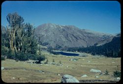
- Description:
- 100 f 8 tl
- Subject:
- Rocks, Grant Lake (Calif.), Mountains, Lakes & ponds, Islands, Hills, Mono Lake (Calif.), and Plants
- Series:
- 27-55
- Creator:
- Cushman, Charles W., 1896-1972
- Date Created:
- 1955-09-26
- Genre:
- Landscape photographs
- Frame Number:
- 13
- Street Address:
- Grant Lake Road
- County:
- Mono
- Abstract:
- Mono Lake from Grant Lake road
- Call Number:
- P08433
- Country:
- United States
- State/Province:
- California
- Alternate Identifier:
- 2755.13
- Persistent URL:
- http://purl.dlib.indiana.edu/iudl/archives/cushman/P08433
- Holding Location:
- Bloomington - University Archives
Wells Library E460
1320 E 10th St.
Bloomington, IN 47405
Contact at archives@indiana.edu, 812-855-1127
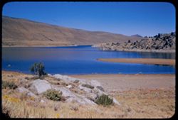
-
- Description:
- 100 f 6.3 sl
- Subject:
- Lakes & ponds, Hills, Waterfronts, Rocks, Plants, and Grant Lake (Calif.)
- Series:
- 27-55
- Creator:
- Cushman, Charles W., 1896-1972
- Date Created:
- 1955-09-26
- Genre:
- Landscape photographs
- Frame Number:
- 12
- County:
- Mono
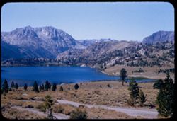
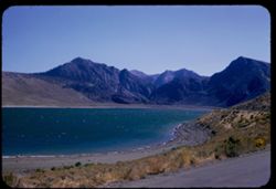
- Abstract:
- Grant lake
- Call Number:
- P08432
- Country:
- United States
- State/Province:
- California
- Alternate Identifier:
- 2755.12
- Persistent URL:
- http://purl.dlib.indiana.edu/iudl/archives/cushman/P08432
- Holding Location:
- Bloomington - University Archives
Wells Library E460
1320 E 10th St.
Bloomington, IN 47405
Contact at archives@indiana.edu, 812-855-1127
-
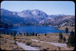
- Description:
- 100 f 5.6 sl
- Subject:
- Lakes & ponds, June Lake (Calif.), Mountains, Trees, and Rocks
- Series:
- 27-55
- Creator:
- Cushman, Charles W., 1896-1972
- Date Created:
- 1955-09-26
- Genre:
- Landscape photographs
- Frame Number:
- 11
- County:
- Mono
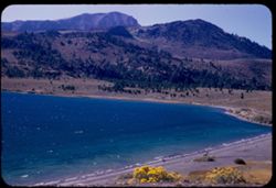
- Abstract:
- Southwestward across June lake
- Call Number:
- P08431
- Country:
- United States
- State/Province:
- California
- Alternate Identifier:
- 2755.11
- Persistent URL:
- http://purl.dlib.indiana.edu/iudl/archives/cushman/P08431
- Holding Location:
- Bloomington - University Archives
Wells Library E460
1320 E 10th St.
Bloomington, IN 47405
Contact at archives@indiana.edu, 812-855-1127
-
- Description:
- 100 f 8 sl
- Subject:
- Trees, June Lake (Calif.), Light, Lakes & ponds, Hills, Reflections, and Mountains
- Series:
- 27-55
- Creator:
- Cushman, Charles W., 1896-1972
- Date Created:
- 1955-09-26
- Genre:
- Landscape photographs
- Frame Number:
- 10
- County:
- Mono
- Abstract:
- Northward across June lake
- Call Number:
- P08430
- Country:
- United States
- State/Province:
- California
- Alternate Identifier:
- 2755.10
- Persistent URL:
- http://purl.dlib.indiana.edu/iudl/archives/cushman/P08430
- Holding Location:
- Bloomington - University Archives
Wells Library E460
1320 E 10th St.
Bloomington, IN 47405
Contact at archives@indiana.edu, 812-855-1127
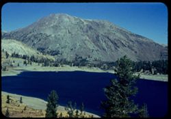
-
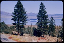
- Description:
- 100 f 8 tl
- Subject:
- Tioga Peak (Calif.), Hills, June Lake (Calif.), Mountains, and Pines
- Series:
- 27-55
- Creator:
- Cushman, Charles W., 1896-1972
- Date Created:
- 1955-09-26
- Genre:
- Landscape photographs
- Frame Number:
- 9
- County:
- Mono
- Abstract:
- from June Lake toward Tioga peak
- Call Number:
- P08429
- Country:
- United States
- State/Province:
- California
- Alternate Identifier:
- 2755.9
- Persistent URL:
- http://purl.dlib.indiana.edu/iudl/archives/cushman/P08429
- Holding Location:
- Bloomington - University Archives
Wells Library E460
1320 E 10th St.
Bloomington, IN 47405
Contact at archives@indiana.edu, 812-855-1127
-
- Description:
- 100 f 5.6 tl
- Subject:
- Lakes & ponds, June Lake (Calif.), Mountains, and Trees
- Series:
- 27-55
- Creator:
- Cushman, Charles W., 1896-1972
- Date Created:
- 1955-09-26
- Genre:
- Landscape photographs
- Frame Number:
- 8
- County:
- Mono
- Abstract:
- June Lake 70,316 mi.
- Call Number:
- P08428
- Country:
- United States
- State/Province:
- California
- Alternate Identifier:
- 2755.8
- Persistent URL:
- http://purl.dlib.indiana.edu/iudl/archives/cushman/P08428
- Holding Location:
- Bloomington - University Archives
Wells Library E460
1320 E 10th St.
Bloomington, IN 47405
Contact at archives@indiana.edu, 812-855-1127
-
- Description:
- 50 f 8 sl
- Subject:
- Lakes & ponds, Roads, June Lake (Calif.), Mountains, and Trees
- Series:
- 27-55
- Creator:
- Cushman, Charles W., 1896-1972
- Date Created:
- 1955-09-26
- Genre:
- Landscape photographs
- Frame Number:
- 7
- County:
- Mono
- Abstract:
- June Lake
- Call Number:
- P08427
- Country:
- United States
- State/Province:
- California
- Alternate Identifier:
- 2755.7
- Persistent URL:
- http://purl.dlib.indiana.edu/iudl/archives/cushman/P08427
- Holding Location:
- Bloomington - University Archives
Wells Library E460
1320 E 10th St.
Bloomington, IN 47405
Contact at archives@indiana.edu, 812-855-1127
-
- Description:
- 50 f 8 sl
- Subject:
- Lakes & ponds, Roads, June Lake (Calif.), Mountains, and Trees
- Series:
- 27-55
- Creator:
- Cushman, Charles W., 1896-1972
- Date Created:
- 1955-09-26
- Genre:
- Landscape photographs
- Frame Number:
- 6
- County:
- Mono
- Abstract:
- June Lake
- Call Number:
- P08426
- Country:
- United States
- State/Province:
- California
- Alternate Identifier:
- 2755.6
- Persistent URL:
- http://purl.dlib.indiana.edu/iudl/archives/cushman/P08426
- Holding Location:
- Bloomington - University Archives
Wells Library E460
1320 E 10th St.
Bloomington, IN 47405
Contact at archives@indiana.edu, 812-855-1127
-
- Description:
- 100 f 8 tl
- Subject:
- Snow, Mountains, Utility poles, and Plants
- Series:
- 27-55
- Creator:
- Cushman, Charles W., 1896-1972
- Date Created:
- 1955-09-26
- Genre:
- Landscape photographs
- Frame Number:
- 5
- Street Address:
- United States Highway 395
- County:
- Mono
- Abstract:
- Fresh snow on Mtn from US 395 at 70296 near Mammoth Lakes
- Call Number:
- P08425
- City:
- Mammoth Lakes
- Country:
- United States
- State/Province:
- California
- Alternate Identifier:
- 2755.5
- Persistent URL:
- http://purl.dlib.indiana.edu/iudl/archives/cushman/P08425
- Holding Location:
- Bloomington - University Archives
Wells Library E460
1320 E 10th St.
Bloomington, IN 47405
Contact at archives@indiana.edu, 812-855-1127
-
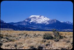
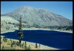
- Description:
- 100 f 7 tl
- Subject:
- Snow, Tom's Place, Mountains, and Lake Crowley (Calif.)
- Series:
- 27-55
- Creator:
- Cushman, Charles W., 1896-1972
- Date Created:
- 1955-09-26
- Genre:
- Landscape photographs
- Frame Number:
- 4
- Street Address:
- United States Highway 395
- County:
- Mono
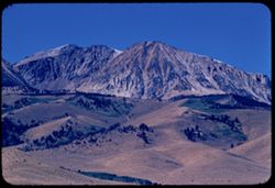
- Abstract:
- Dark red mtn nearby
- Call Number:
- P08424
- Country:
- United States
- State/Province:
- California
- Alternate Identifier:
- 2755.4
- Persistent URL:
- http://purl.dlib.indiana.edu/iudl/archives/cushman/P08424
- Holding Location:
- Bloomington - University Archives
Wells Library E460
1320 E 10th St.
Bloomington, IN 47405
Contact at archives@indiana.edu, 812-855-1127
-
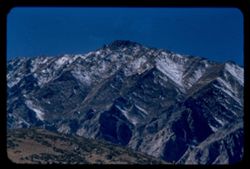
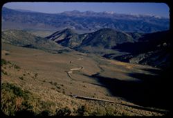
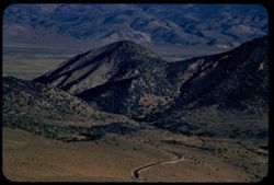
- Description:
- 100 f 8 tl
- Subject:
- Rocks, Mountains, Fences, Lake Crowley (Calif.), Sierra Nevada (Calif. and Nev.), and Utility poles
- Series:
- 27-55
- Creator:
- Cushman, Charles W., 1896-1972
- Date Created:
- 1955-09-26
- Genre:
- Landscape photographs
- Frame Number:
- 3
- County:
- Mono
- Abstract:
- Red & gray [jagged] peak west of Crowley Lake
- Call Number:
- P08423
- Country:
- United States
- State/Province:
- California
- Alternate Identifier:
- 2755.3
- Persistent URL:
- http://purl.dlib.indiana.edu/iudl/archives/cushman/P08423
- Holding Location:
- Bloomington - University Archives
Wells Library E460
1320 E 10th St.
Bloomington, IN 47405
Contact at archives@indiana.edu, 812-855-1127
-
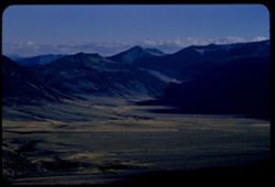
- Description:
- 100 f 8 tl
- Subject:
- Valleys, Mountains, Lakes & ponds, Lake Crowley (Calif.), and Land
- Series:
- 27-55
- Creator:
- Cushman, Charles W., 1896-1972
- Date Created:
- 1955-09-26
- Genre:
- Landscape photographs
- Frame Number:
- 2
- Street Address:
- United States Highway 395
- County:
- Mono
- Abstract:
- View north across valley to distant pks
- Call Number:
- P08422
- Country:
- United States
- State/Province:
- California
- Alternate Identifier:
- 2755.2
- Persistent URL:
- http://purl.dlib.indiana.edu/iudl/archives/cushman/P08422
- Holding Location:
- Bloomington - University Archives
Wells Library E460
1320 E 10th St.
Bloomington, IN 47405
Contact at archives@indiana.edu, 812-855-1127
-
- Description:
- 100 f 8 tl
- Subject:
- Lakes & ponds, Mountains, Waterfronts, and Lake Crowley (Calif.)
- Series:
- 27-55
- Creator:
- Cushman, Charles W., 1896-1972
- Date Created:
- 1955-09-26
- Genre:
- Landscape photographs
- Frame Number:
- 1
- Street Address:
- United States Highway 395
- County:
- Mono
- Abstract:
- Crowley Lake from US 395 above
- Call Number:
- P08421
- Country:
- United States
- State/Province:
- California
- Alternate Identifier:
- 2755.1
- Persistent URL:
- http://purl.dlib.indiana.edu/iudl/archives/cushman/P08421
- Holding Location:
- Bloomington - University Archives
Wells Library E460
1320 E 10th St.
Bloomington, IN 47405
Contact at archives@indiana.edu, 812-855-1127
-
- Description:
- 100 f 7 tl
- Subject:
- Mountains, Plants, Waterfronts, Lake Crowley (Calif.), and Lakes & ponds
- Series:
- 27-55
- Creator:
- Cushman, Charles W., 1896-1972
- Date Created:
- 1955-09-26
- Genre:
- Landscape photographs
- Frame Number:
- 0
- Street Address:
- United States Highway 395
- County:
- Mono
- Abstract:
- Crowley Lake from US 395 above
- Call Number:
- P08420
- Country:
- United States
- State/Province:
- California
- Alternate Identifier:
- 2755.0
- Persistent URL:
- http://purl.dlib.indiana.edu/iudl/archives/cushman/P08420
- Holding Location:
- Bloomington - University Archives
Wells Library E460
1320 E 10th St.
Bloomington, IN 47405
Contact at archives@indiana.edu, 812-855-1127
-
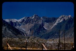
- Description:
- 100 f 8 tl
- Subject:
- Mountains, Sierra Nevada (Calif. and Nev.), Trees, and Lake Crowley (Calif.)
- Series:
- 26-55
- Creator:
- Cushman, Charles W., 1896-1972
- Date Created:
- 1955-09-26
- Genre:
- Landscape photographs
- Frame Number:
- 37
- Street Address:
- United States Highway 395
- County:
- Mono
- Abstract:
- Mtn above Crowley Lake
- Call Number:
- P08419
- Country:
- United States
- State/Province:
- California
- Alternate Identifier:
- 2655.37
- Persistent URL:
- http://purl.dlib.indiana.edu/iudl/archives/cushman/P08419
- Holding Location:
- Bloomington - University Archives
Wells Library E460
1320 E 10th St.
Bloomington, IN 47405
Contact at archives@indiana.edu, 812-855-1127
-
- Description:
- 100 f 7 tl
- Subject:
- Snow, Trees, Mountains, Rock formations, Sierra Nevada (Calif. and Nev.), and Utility poles
- Series:
- 26-55
- Creator:
- Cushman, Charles W., 1896-1972
- Date Created:
- 1955-09-26
- Genre:
- Landscape photographs
- Frame Number:
- 36
- Street Address:
- United States Highway 395
- County:
- Mono
- Abstract:
- Striped snow at top of anohter mountain to left of that 35
- Call Number:
- P08418
- Country:
- United States
- State/Province:
- California
- Alternate Identifier:
- 2655.36
- Persistent URL:
- http://purl.dlib.indiana.edu/iudl/archives/cushman/P08418
- Holding Location:
- Bloomington - University Archives
Wells Library E460
1320 E 10th St.
Bloomington, IN 47405
Contact at archives@indiana.edu, 812-855-1127
-
- Description:
- 100 f 5.6 SL
- Subject:
- Valleys, Roads, Shadows, Mountains, Antelope Valley (Calif.), Land, Monitor Pass (Calif.), Sweetwater Mountains (Calif. and Nev.), and Plants
- Series:
- 25-55
- Creator:
- Cushman, Charles W., 1896-1972
- Date Created:
- 1955-09-24
- Genre:
- Landscape photographs
- Frame Number:
- 22
- Street Address:
- California State Highway 89
- County:
- Mono and Alpine
- Abstract:
- Across to high Sweetwater mtns SE.
- Call Number:
- P08370
- City:
- Coleville
- Country:
- United States
- State/Province:
- California
- Alternate Identifier:
- 2555.22
- Persistent URL:
- http://purl.dlib.indiana.edu/iudl/archives/cushman/P08370
- Holding Location:
- Bloomington - University Archives
Wells Library E460
1320 E 10th St.
Bloomington, IN 47405
Contact at archives@indiana.edu, 812-855-1127
-
- Description:
- 100 f 7 TL
- Subject:
- Valleys, Mountains, Slinkard Valley (Calif.), Monitor Pass (Calif.), and Clouds
- Series:
- 25-55
- Creator:
- Cushman, Charles W., 1896-1972
- Date Created:
- 1955-09-24
- Genre:
- Landscape photographs
- Frame Number:
- 21
- County:
- Mono and Alpine
- Abstract:
- And to south into Slinkard's Valley
- Call Number:
- P08369
- City:
- Coleville
- Country:
- United States
- State/Province:
- California
- Alternate Identifier:
- 2555.21
- Persistent URL:
- http://purl.dlib.indiana.edu/iudl/archives/cushman/P08369
- Holding Location:
- Bloomington - University Archives
Wells Library E460
1320 E 10th St.
Bloomington, IN 47405
Contact at archives@indiana.edu, 812-855-1127
-

- Description:
- 100 f 7 TL
- Subject:
- Shadows, Mountains, Monitor Pass (Calif.), and Sweetwater Mountains (Calif. and Nev.)
- Series:
- 25-55
- Creator:
- Cushman, Charles W., 1896-1972
- Date Created:
- 1955-09-24
- Genre:
- Landscape photographs
- Frame Number:
- 20
- Street Address:
- California State Highway 89
- County:
- Mono
- Abstract:
- Across to high Sweetwater mtns SE.
- Call Number:
- P08368
- City:
- Coleville
- Country:
- United States
- State/Province:
- California
- Alternate Identifier:
- 2555.20
- Persistent URL:
- http://purl.dlib.indiana.edu/iudl/archives/cushman/P08368
- Holding Location:
- Bloomington - University Archives
Wells Library E460
1320 E 10th St.
Bloomington, IN 47405
Contact at archives@indiana.edu, 812-855-1127
-
- Description:
- 100 f 6.3 TL
- Subject:
- Roads, Mountains, Antelope Valley (Calif.), Monitor Pass (Calif.), and Plants
- Series:
- 25-55
- Creator:
- Cushman, Charles W., 1896-1972
- Date Created:
- 1955-09-24
- Genre:
- Landscape photographs
- Frame Number:
- 19
- Street Address:
- United States Highway 395 and California State Highway 89
- County:
- Alpine and Mono
- Abstract:
- View far down on Hwy 89 from far up [L]
- Call Number:
- P08367
- City:
- Coleville
- Country:
- United States
- State/Province:
- California
- Alternate Identifier:
- 2555.19
- Persistent URL:
- http://purl.dlib.indiana.edu/iudl/archives/cushman/P08367
- Holding Location:
- Bloomington - University Archives
Wells Library E460
1320 E 10th St.
Bloomington, IN 47405
Contact at archives@indiana.edu, 812-855-1127
-
- Description:
- 100 f 6.3 TL
- Subject:
- Roads, Antelope Valley (Calif.), Land, Trucks, Monitor Pass (Calif.), and Plants
- Series:
- 25-55
- Creator:
- Cushman, Charles W., 1896-1972
- Date Created:
- 1955-09-24
- Genre:
- Views
- Frame Number:
- 18
- Street Address:
- United States Highway 395 and California State Highway 89
- County:
- Mono and Alpine
- Abstract:
- View far down on Hwy 89 from far up
- Call Number:
- P08366
- City:
- Coleville
- Country:
- United States
- State/Province:
- California
- Alternate Identifier:
- 2555.18
- Persistent URL:
- http://purl.dlib.indiana.edu/iudl/archives/cushman/P08366
- Holding Location:
- Bloomington - University Archives
Wells Library E460
1320 E 10th St.
Bloomington, IN 47405
Contact at archives@indiana.edu, 812-855-1127
-
- Description:
- 100 f 6.3 TL
- Subject:
- Sonora Pass (Calif.), Shadows, Mountains, Clouds, Monitor Pass (Calif.), and Sonora Mountains (Calif.)
- Series:
- 25-55
- Creator:
- Cushman, Charles W., 1896-1972
- Date Created:
- 1955-09-24
- Genre:
- Landscape photographs
- Frame Number:
- 17
- Street Address:
- California State Highway 89
- County:
- Alpine and Mono
- Abstract:
- View south toward Sonora mtns
- Call Number:
- P08365
- City:
- Coleville
- Country:
- United States
- State/Province:
- California
- Alternate Identifier:
- 2555.17
- Persistent URL:
- http://purl.dlib.indiana.edu/iudl/archives/cushman/P08365
- Holding Location:
- Bloomington - University Archives
Wells Library E460
1320 E 10th St.
Bloomington, IN 47405
Contact at archives@indiana.edu, 812-855-1127
-
- Description:
- 100 f 6.3 TL
- Subject:
- Sweetwater Mountains (Calif. and Nev.), Mountains, Antelope Valley (Calif.), Land, and Monitor Pass (Calif.)
- Series:
- 25-55
- Creator:
- Cushman, Charles W., 1896-1972
- Date Created:
- 1955-09-24
- Genre:
- Landscape photographs
- Frame Number:
- 16
- Street Address:
- California State Highway 89
- County:
- Alpine and Mono
- Abstract:
- From same pt. SE
- Call Number:
- P08364
- Country:
- United States
- State/Province:
- California
- Alternate Identifier:
- 2555.16
- Persistent URL:
- http://purl.dlib.indiana.edu/iudl/archives/cushman/P08364
- Holding Location:
- Bloomington - University Archives
Wells Library E460
1320 E 10th St.
Bloomington, IN 47405
Contact at archives@indiana.edu, 812-855-1127
-
- Description:
- 100 f 6.3 TL
- Subject:
- Mountains, Antelope Valley (Calif.), Mounds (Landforms), Monitor Pass (Calif.), Sweetwater Mountains (Calif. and Nev.), and Land
- Series:
- 25-55
- Creator:
- Cushman, Charles W., 1896-1972
- Date Created:
- 1955-09-24
- Genre:
- Landscape photographs
- Frame Number:
- 15
- Street Address:
- California State Highway 89
- County:
- Mono and Alpine
- Abstract:
- From same pt. SE
- Call Number:
- P08363
- City:
- Coleville
- Country:
- United States
- State/Province:
- California
- Physical Description:
- Image was originally mounted in a glass enclosure. Before digitization, the image was removed and placed in a Wess Plastic, Inc. brand, 2" x 2", pl...
- Alternate Identifier:
- 2555.15
- Persistent URL:
- http://purl.dlib.indiana.edu/iudl/archives/cushman/P08363
- Holding Location:
- Bloomington - University Archives
Wells Library E460
1320 E 10th St.
Bloomington, IN 47405
Contact at archives@indiana.edu, 812-855-1127
-
- Description:
- 100 f 8 SL
- Subject:
- Grasses, Mountains, and Hills
- Series:
- 25-55
- Creator:
- Cushman, Charles W., 1896-1972
- Date Created:
- 1955-09-24
- Genre:
- Landscape photographs
- Frame Number:
- 14
- Street Address:
- California State Highway 89
- County:
- Alpine and Mono
- Abstract:
- East by So. From same pt.
- Call Number:
- P08362
- City:
- Coleville
- Country:
- United States
- State/Province:
- California
- Alternate Identifier:
- 2555.14
- Persistent URL:
- http://purl.dlib.indiana.edu/iudl/archives/cushman/P08362
- Holding Location:
- Bloomington - University Archives
Wells Library E460
1320 E 10th St.
Bloomington, IN 47405
Contact at archives@indiana.edu, 812-855-1127
-
- Description:
- 100 f 7 SL
- Subject:
- Shadows, Mountains, Antelope Valley (Calif.), Monitor Pass (Calif.), Hills, Sweetwater Mountains (Calif. and Nev.), and Plants
- Series:
- 25-55
- Creator:
- Cushman, Charles W., 1896-1972
- Date Created:
- 1955-09-24
- Genre:
- Landscape photographs
- Frame Number:
- 13
- Street Address:
- California State Highway 89
- County:
- Alpine and Mono
- Abstract:
- View SE from Cal Hwy 89 at Mono Alpine county line 7910 ft (Monitor Pass)
- Call Number:
- P08361
- Country:
- United States
- State/Province:
- California
- Alternate Identifier:
- 2555.13
- Persistent URL:
- http://purl.dlib.indiana.edu/iudl/archives/cushman/P08361
- Holding Location:
- Bloomington - University Archives
Wells Library E460
1320 E 10th St.
Bloomington, IN 47405
Contact at archives@indiana.edu, 812-855-1127
-
- Description:
- 100 f 8 tl
- Subject:
- Deserts, Valleys, Black Mountains (Inyo County, Calif.), Death Valley (Calif. and Nev.), Mountains, Shrubs, and Furnace Creek (Calif.)
- Series:
- 9-55
- Creator:
- Cushman, Charles W., 1896-1972
- Date Created:
- 1955-03-22
- Genre:
- Landscape photographs
- Frame Number:
- 26
- Street Address:
- Furnace Creek-Bad Water Road
- County:
- Mono and Inyo
- Abstract:
- From Bad Water road near exit to Golden Canyon
- Call Number:
- P07817
- City:
- Badwater
- Country:
- United States
- State/Province:
- California
- Alternate Identifier:
- 955.26
- Persistent URL:
- http://purl.dlib.indiana.edu/iudl/archives/cushman/P07817
- Holding Location:
- Bloomington - University Archives
Wells Library E460
1320 E 10th St.
Bloomington, IN 47405
Contact at archives@indiana.edu, 812-855-1127
-
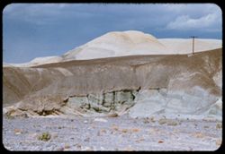
- Description:
- 200 f 5.6
- Subject:
- Rocks, Rock formations, Mounds (Landforms), Death Valley (Calif. and Nev.), Utility poles, Shrubs, Clouds, and Domes
- Series:
- 3-55
- Creator:
- Cushman, Charles W., 1896-1972
- Date Created:
- 1955-02-27
- Genre:
- Landscape photographs
- Frame Number:
- 15
- County:
- Mono
- Abstract:
- White sand dome near Furnace Ck.
- Call Number:
- P07607
- City:
- Furnace Creek
- Country:
- United States
- State/Province:
- California
- Alternate Identifier:
- 355.15
- Persistent URL:
- http://purl.dlib.indiana.edu/iudl/archives/cushman/P07607
- Holding Location:
- Bloomington - University Archives
Wells Library E460
1320 E 10th St.
Bloomington, IN 47405
Contact at archives@indiana.edu, 812-855-1127
-
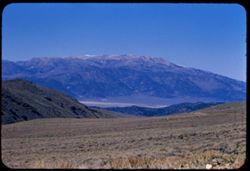
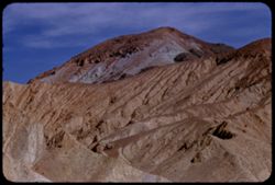
- Description:
- 100 f 8 tl
- Subject:
- Rocks, Mountains, Rock formations, Clouds, and Death Valley (Calif. and Nev.)
- Series:
- 3-55
- Creator:
- Cushman, Charles W., 1896-1972
- Date Created:
- 1955-02-27
- Genre:
- Landscape photographs
- Frame Number:
- 13
- County:
- Mono
- Abstract:
- Approaching Furnace Creek = a big back drop
- Call Number:
- P07605
- City:
- Furnace Creek
- Country:
- United States
- State/Province:
- California
- Alternate Identifier:
- 355.13
- Persistent URL:
- http://purl.dlib.indiana.edu/iudl/archives/cushman/P07605
- Holding Location:
- Bloomington - University Archives
Wells Library E460
1320 E 10th St.
Bloomington, IN 47405
Contact at archives@indiana.edu, 812-855-1127
-
- Description:
- 100 f 8 tl
- Subject:
- Hills, Funeral Mountains (Calif.), Funeral Mountains Wilderness (Calif.), Mountains, Shrubs, Furnace Creek (Calif.), Rocks, and Clouds
- Series:
- 2-55
- Creator:
- Cushman, Charles W., 1896-1972
- Date Created:
- 1955-02-27
- Genre:
- Landscape photographs
- Frame Number:
- 29
- Street Address:
- Furance Creek-Death Valley Junction Road
- County:
- Mono and Inyo
- Abstract:
- North toward Funeral Mtns
- Call Number:
- P07586
- City:
- Death Valley Junction
- Country:
- United States
- State/Province:
- California
- Alternate Identifier:
- 255.29
- Persistent URL:
- http://purl.dlib.indiana.edu/iudl/archives/cushman/P07586
- Holding Location:
- Bloomington - University Archives
Wells Library E460
1320 E 10th St.
Bloomington, IN 47405
Contact at archives@indiana.edu, 812-855-1127
-
- Description:
- 50 f 6.3
- Subject:
- Bodies of water, Trees, Coastlines, June Lake (Calif.), Shrubs, Lakes & ponds, Flowers, and Mountains
- Series:
- 11-54
- Creator:
- Cushman, Charles W., 1896-1972
- Date Created:
- 1954-09-16
- Genre:
- Landscape photographs
- Frame Number:
- 3
- County:
- Mono
- Abstract:
- June Lake from east side in mid afternoon.
- Call Number:
- P07372
- Country:
- United States
- State/Province:
- California
- Alternate Identifier:
- 1154.3
- Persistent URL:
- http://purl.dlib.indiana.edu/iudl/archives/cushman/P07372
- Holding Location:
- Bloomington - University Archives
Wells Library E460
1320 E 10th St.
Bloomington, IN 47405
Contact at archives@indiana.edu, 812-855-1127
-
- Description:
- 50 f 8
- Subject:
- Lakes & ponds, Bodies of water, Mountains, Shrubs, Trees, Coastlines, and Grant Lake (Calif.)
- Series:
- 11-54
- Creator:
- Cushman, Charles W., 1896-1972
- Date Created:
- 1954-09-16
- Genre:
- Landscape photographs
- Frame Number:
- 2
- County:
- Mono
- Abstract:
- Grant Lake.
- Call Number:
- P07371
- Country:
- United States
- State/Province:
- California
- Alternate Identifier:
- 1154.2
- Persistent URL:
- http://purl.dlib.indiana.edu/iudl/archives/cushman/P07371
- Holding Location:
- Bloomington - University Archives
Wells Library E460
1320 E 10th St.
Bloomington, IN 47405
Contact at archives@indiana.edu, 812-855-1127
-
- Description:
- 50 f 11
- Subject:
- Bodies of water, Roads, Trees, Mountains, Shrubs, Lakes & ponds, Islands, Utility poles, and Mono Lake (Calif.)
- Series:
- 11-54
- Creator:
- Cushman, Charles W., 1896-1972
- Date Created:
- 1954-09-16
- Genre:
- Landscape photographs
- Frame Number:
- 1
- Street Address:
- Tioga Pass Road
- County:
- Mono
- Abstract:
- Mono Lake from Tioga Pass Road.
- Call Number:
- P07370
- City:
- Lee Vining
- Country:
- United States
- State/Province:
- California
- Physical Description:
- masked.
- Alternate Identifier:
- 1154.1
- Persistent URL:
- http://purl.dlib.indiana.edu/iudl/archives/cushman/P07370
- Holding Location:
- Bloomington - University Archives
Wells Library E460
1320 E 10th St.
Bloomington, IN 47405
Contact at archives@indiana.edu, 812-855-1127
-
- Description:
- 50 f 8
- Subject:
- Rocks, Valleys, Lee Vining Canyon (Calif.), Roads, Mono Basin (Calif.), Trees, Lee Vining Creek (Calif.), Mountains, Shrubs, and Canyons
- Series:
- 10-54
- Creator:
- Cushman, Charles W., 1896-1972
- Date Created:
- 1954-09-16
- Genre:
- Landscape photographs
- Frame Number:
- 22
- County:
- Mono
- Abstract:
- Another view east down canyon - a little vurther along.
- Call Number:
- P07369
- Country:
- United States
- State/Province:
- California
- Physical Description:
- Anscochrome film.
- Alternate Identifier:
- 1054.22
- Persistent URL:
- http://purl.dlib.indiana.edu/iudl/archives/cushman/P07369
- Holding Location:
- Bloomington - University Archives
Wells Library E460
1320 E 10th St.
Bloomington, IN 47405
Contact at archives@indiana.edu, 812-855-1127
-
- Description:
- 50 f 9
- Subject:
- Rocks, Canyons, Grasses, Trees, Flowers, Lee Vining Creek (Calif.), Mountains, Shrubs, and Lee Vining Canyon (Calif.)
- Series:
- 10-54
- Creator:
- Cushman, Charles W., 1896-1972
- Date Created:
- 1954-09-16
- Genre:
- Landscape photographs
- Frame Number:
- 21
- County:
- Mono
- Abstract:
- Another view east down canyon.
- Call Number:
- P07368
- Country:
- United States
- State/Province:
- California
- Physical Description:
- Anscochrome film.
- Alternate Identifier:
- 1054.21
- Persistent URL:
- http://purl.dlib.indiana.edu/iudl/archives/cushman/P07368
- Holding Location:
- Bloomington - University Archives
Wells Library E460
1320 E 10th St.
Bloomington, IN 47405
Contact at archives@indiana.edu, 812-855-1127
-
- Description:
- 50 f 8
- Subject:
- Rocks, Canyons, Cliffs, Trees, Lee Vining Creek (Calif.), Mountains, and Shrubs
- Series:
- 10-54
- Creator:
- Cushman, Charles W., 1896-1972
- Date Created:
- 1954-09-16
- Genre:
- Landscape photographs
- Frame Number:
- 20
- Street Address:
- California State Highway 140
- County:
- Mono
- Abstract:
- View down into canyon.
- Call Number:
- P07367
- City:
- Lee Vining
- Country:
- United States
- State/Province:
- California
- Physical Description:
- Anscochrome film.
- Alternate Identifier:
- 1054.20
- Persistent URL:
- http://purl.dlib.indiana.edu/iudl/archives/cushman/P07367
- Holding Location:
- Bloomington - University Archives
Wells Library E460
1320 E 10th St.
Bloomington, IN 47405
Contact at archives@indiana.edu, 812-855-1127
-
- Description:
- 50 f 10
- Subject:
- Rocks, Canyons, Trees, Lee Vining Creek (Calif.), Mountains, Shrubs, Passes (Landforms), and Valleys
- Series:
- 10-54
- Creator:
- Cushman, Charles W., 1896-1972
- Date Created:
- 1954-09-16
- Genre:
- Landscape photographs
- Frame Number:
- 19
- Street Address:
- Tioga Pass Road
- County:
- Mono
- Abstract:
- View east down Tioga Pass road to Leevining.
- Call Number:
- P07366
- Country:
- United States
- State/Province:
- California
- Physical Description:
- Anscochrome film, film scratched.
- Alternate Identifier:
- 1054.19
- Persistent URL:
- http://purl.dlib.indiana.edu/iudl/archives/cushman/P07366
- Holding Location:
- Bloomington - University Archives
Wells Library E460
1320 E 10th St.
Bloomington, IN 47405
Contact at archives@indiana.edu, 812-855-1127
-
- Description:
- 50 f 9
- Subject:
- Trees, Lee Vining Creek (Calif.), Rock formations, and Shrubs
- Series:
- 10-54
- Creator:
- Cushman, Charles W., 1896-1972
- Date Created:
- 1954-09-16
- Genre:
- Landscape photographs
- Frame Number:
- 17
- Street Address:
- Tioga Pass Road
- County:
- Mono
- Abstract:
- View up from same turnout.
- Call Number:
- P07365
- Country:
- United States
- State/Province:
- California
- Physical Description:
- Anscochrome film.
- Alternate Identifier:
- 1054.17
- Persistent URL:
- http://purl.dlib.indiana.edu/iudl/archives/cushman/P07365
- Holding Location:
- Bloomington - University Archives
Wells Library E460
1320 E 10th St.
Bloomington, IN 47405
Contact at archives@indiana.edu, 812-855-1127
-
- Description:
- 50 f 9
- Subject:
- Rocks, Canyons, Mono Basin (Calif.), Trees, Flowers, Lee Vining Creek (Calif.), and Shrubs
- Series:
- 10-54
- Creator:
- Cushman, Charles W., 1896-1972
- Date Created:
- 1954-09-16
- Genre:
- Landscape photographs
- Frame Number:
- 16
- Street Address:
- Tioga Pass Road
- County:
- Mono
- Abstract:
- Two views east down Tioga Pass Rd.
- Call Number:
- P07363
- Country:
- United States
- State/Province:
- California
- Physical Description:
- Anscochrome film.
- Alternate Identifier:
- 1054.16
- Persistent URL:
- http://purl.dlib.indiana.edu/iudl/archives/cushman/P07363
- Holding Location:
- Bloomington - University Archives
Wells Library E460
1320 E 10th St.
Bloomington, IN 47405
Contact at archives@indiana.edu, 812-855-1127
-
- Description:
- 50 f 9
- Subject:
- Rocks, Canyons, Trees, Lee Vining Creek (Calif.), Shrubs, and Dwellings
- Series:
- 10-54
- Creator:
- Cushman, Charles W., 1896-1972
- Date Created:
- 1954-09-16
- Genre:
- Landscape photographs
- Frame Number:
- 18
- Street Address:
- California State Highway 140 and Tioga Pass Road
- County:
- Mono
- Abstract:
- Down into canyon.
- Call Number:
- P07364
- Country:
- United States
- State/Province:
- California
- Physical Description:
- Anscochrome film.
- Alternate Identifier:
- 1054.18
- Persistent URL:
- http://purl.dlib.indiana.edu/iudl/archives/cushman/P07364
- Holding Location:
- Bloomington - University Archives
Wells Library E460
1320 E 10th St.
Bloomington, IN 47405
Contact at archives@indiana.edu, 812-855-1127
-
- Description:
- 50 f 9
- Subject:
- Rocks, Canyons, Trees, Mountains, and Shrubs
- Series:
- 10-54
- Creator:
- Cushman, Charles W., 1896-1972
- Date Created:
- 1954-09-16
- Genre:
- Landscape photographs
- Frame Number:
- 15
- Street Address:
- Tioga Pass Road
- County:
- Mono
- Abstract:
- Two views east down Tioga Pass Rd.
- Call Number:
- P07362
- Country:
- United States
- State/Province:
- California
- Physical Description:
- Anscochrome film.
- Alternate Identifier:
- 1054.15
- Persistent URL:
- http://purl.dlib.indiana.edu/iudl/archives/cushman/P07362
- Holding Location:
- Bloomington - University Archives
Wells Library E460
1320 E 10th St.
Bloomington, IN 47405
Contact at archives@indiana.edu, 812-855-1127
-
- Description:
- 100 f 6
- Subject:
- Rocks, Trees, Shrubs, and Rock formations
- Series:
- 10-54
- Creator:
- Cushman, Charles W., 1896-1972
- Date Created:
- 1954-09-16
- Genre:
- Landscape photographs
- Frame Number:
- 14
- Street Address:
- Tioga Pass Road
- County:
- Mono
- Abstract:
- The granite pinnacle again.
- Call Number:
- P07361
- Country:
- United States
- State/Province:
- California
- Physical Description:
- Image was originally mounted in a glass enclosure. Before digitization, the image was removed and placed in a Wess Plastic, Inc. brand, 2" x 2", pl...
- Alternate Identifier:
- 1054.14
- Persistent URL:
- http://purl.dlib.indiana.edu/iudl/archives/cushman/P07361
- Holding Location:
- Bloomington - University Archives
Wells Library E460
1320 E 10th St.
Bloomington, IN 47405
Contact at archives@indiana.edu, 812-855-1127
-
- Description:
- 100 f 6
- Subject:
- Canyons, Trees, Lee Vining Creek (Calif.), Mountains, and Shrubs
- Series:
- 10-54
- Creator:
- Cushman, Charles W., 1896-1972
- Date Created:
- 1954-09-16
- Genre:
- Landscape photographs
- Frame Number:
- 13
- Street Address:
- Tioga Pass Road
- County:
- Mono
- Abstract:
- Great granite mountain.
- Call Number:
- P07360
- Country:
- United States
- State/Province:
- California
- Physical Description:
- Image was originally mounted in a glass enclosure. Before digitization, the image was removed and placed in a Wess Plastic, Inc. brand, 2" x 2", pl...
- Alternate Identifier:
- 1054.13
- Persistent URL:
- http://purl.dlib.indiana.edu/iudl/archives/cushman/P07360
- Holding Location:
- Bloomington - University Archives
Wells Library E460
1320 E 10th St.
Bloomington, IN 47405
Contact at archives@indiana.edu, 812-855-1127
-
- Description:
- 50 f 9
- Subject:
- Rocks, Roads, Trees, Buttes, Signs (Notices), Tioga Pass (Calif.), Mountains, Rock formations, and Shrubs
- Series:
- 10-54
- Creator:
- Cushman, Charles W., 1896-1972
- Date Created:
- 1954-09-16
- Genre:
- Landscape photographs
- Frame Number:
- 12
- Street Address:
- California State Highway 140 and Tioga Pass Road
- County:
- Mono
- Abstract:
- Granite [pinnacle?] on downgrade of Tioga Pass road.
- Call Number:
- P07359
- Country:
- United States
- State/Province:
- California
- Physical Description:
- Anscochrome film.
- Alternate Identifier:
- 1054.12
- Persistent URL:
- http://purl.dlib.indiana.edu/iudl/archives/cushman/P07359
- Holding Location:
- Bloomington - University Archives
Wells Library E460
1320 E 10th St.
Bloomington, IN 47405
Contact at archives@indiana.edu, 812-855-1127
-
- Description:
- 50 f 9
- Subject:
- Rocks, Trees, Tioga Peak (Calif.), Mountains, and Shrubs
- Series:
- 10-54
- Creator:
- Cushman, Charles W., 1896-1972
- Date Created:
- 1954-09-16
- Genre:
- Landscape photographs
- Frame Number:
- 11
- Street Address:
- California State Highway 140
- County:
- Mono
- Abstract:
- Top of Tioga Pk from below.
- Call Number:
- P07358
- Country:
- United States
- State/Province:
- California
- Physical Description:
- Anscochrome film.
- Alternate Identifier:
- 1054.11
- Persistent URL:
- http://purl.dlib.indiana.edu/iudl/archives/cushman/P07358
- Holding Location:
- Bloomington - University Archives
Wells Library E460
1320 E 10th St.
Bloomington, IN 47405
Contact at archives@indiana.edu, 812-855-1127
-
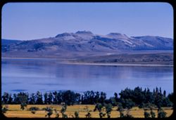
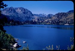
- Description:
- 50 f 10
- Subject:
- Bodies of water, Rocks, Mountains, Trees, Dana Plateau (Calif.), Ellery Lake (Calif.), Shrubs, and Lakes & ponds
- Series:
- 10-54
- Creator:
- Cushman, Charles W., 1896-1972
- Date Created:
- 1954-09-16
- Genre:
- Landscape photographs
- Frame Number:
- 10
- County:
- Mono
- Abstract:
- View east across Ellery Lake.
- Call Number:
- P07357
- Country:
- United States
- State/Province:
- California
- Physical Description:
- Anscochrome film.
- Alternate Identifier:
- 1054.10
- Persistent URL:
- http://purl.dlib.indiana.edu/iudl/archives/cushman/P07357
- Holding Location:
- Bloomington - University Archives
Wells Library E460
1320 E 10th St.
Bloomington, IN 47405
Contact at archives@indiana.edu, 812-855-1127
-
- Description:
- 50 f 8.8
- Subject:
- Yosemite National Park (Calif.), Tioga Peak (Calif.), Mountains, Trees, Streams, Shrubs, Roads, Rocks, and Tioga Pass (Calif.)
- Series:
- 10-54
- Creator:
- Cushman, Charles W., 1896-1972
- Date Created:
- 1954-09-16
- Genre:
- Landscape photographs
- Frame Number:
- 9
- County:
- Mono
- Abstract:
- Great red brown mtn next to Tioga Pk.
- Call Number:
- P07356
- Country:
- United States
- State/Province:
- California
- Physical Description:
- Anscochrome film.
- Alternate Identifier:
- 1054.9
- Persistent URL:
- http://purl.dlib.indiana.edu/iudl/archives/cushman/P07356
- Holding Location:
- Bloomington - University Archives
Wells Library E460
1320 E 10th St.
Bloomington, IN 47405
Contact at archives@indiana.edu, 812-855-1127
-
- Description:
- 50 f 9
- Subject:
- Bodies of water, Yosemite National Park (Calif.), Trees, Coastlines, Tioga Peak (Calif.), Mountains, Shrubs, Lakes & ponds, and Tioga Lake (Calif.)
- Series:
- 10-54
- Creator:
- Cushman, Charles W., 1896-1972
- Date Created:
- 1954-09-16
- Genre:
- Landscape photographs
- Frame Number:
- 8
- County:
- Mono
- Abstract:
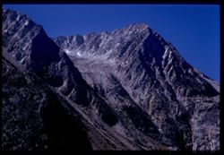
- Tioga Lake and Tioga Pk. Tioga Peak 11,537 ft.
- Call Number:
- P07355
- Country:
- United States
- State/Province:
- California
- Physical Description:
- Anscochrome film.
- Alternate Identifier:
- 1054.8
- Persistent URL:
- http://purl.dlib.indiana.edu/iudl/archives/cushman/P07355
- Holding Location:
- Bloomington - University Archives
Wells Library E460
1320 E 10th St.
Bloomington, IN 47405
Contact at archives@indiana.edu, 812-855-1127
-
- Description:
- 50 f 9
- Subject:
- Lakes & ponds, Tioga Peak (Calif.), Bodies of water, Tioga Lake (Calif.), Mountains, Shrubs, Trees, and Coastlines
- Series:
- 10-54
- Creator:
- Cushman, Charles W., 1896-1972
- Date Created:
- 1954-09-16
- Genre:
- Landscape photographs
- Frame Number:
- 7
- County:
- Mono
- Abstract:
- Tioga Lake and Tioga Pk. Tioga Peak 11,537 ft.
- Call Number:
- P07354
- Country:
- United States
- State/Province:
- California
- Physical Description:
- Image was originally mounted in a glass enclosure. Before digitization, the image was removed and placed in a Wess Plastic, Inc. brand, 2" x 2", pl...
- Alternate Identifier:
- 1054.7
- Persistent URL:
- http://purl.dlib.indiana.edu/iudl/archives/cushman/P07354
- Holding Location:
- Bloomington - University Archives
Wells Library E460
1320 E 10th St.
Bloomington, IN 47405
Contact at archives@indiana.edu, 812-855-1127
-
- Description:
- 50 f 9
- Subject:
- Rocks, Bodies of water, Yosemite National Park (Calif.), Trees, Meadows, Tioga Peak (Calif.), Tioga Pass (Calif.), Mountains, Shrubs, Lakes & ponds, and ...
- Series:
- 10-54
- Creator:
- Cushman, Charles W., 1896-1972
- Date Created:
- 1954-09-16
- Genre:
- Landscape photographs
- Frame Number:
- 6
- County:
- Mono
- Abstract:
- Tioga Pk (11,537) across Tioga Lake from entrance to Yosemite Pk.
- Call Number:
- P07353
- Country:
- United States
- State/Province:
- California
- Physical Description:
- Anscochrome film.
- Alternate Identifier:
- 1054.6
- Persistent URL:
- http://purl.dlib.indiana.edu/iudl/archives/cushman/P07353
- Holding Location:
- Bloomington - University Archives
Wells Library E460
1320 E 10th St.
Bloomington, IN 47405
Contact at archives@indiana.edu, 812-855-1127
-
- Description:
- 50 f 8
- Subject:
- Lakes & ponds, Passes (Landforms), Bodies of water, Tioga Lake (Calif.), Mountains, Dirt roads, Shrubs, Trees, Buttes, Tioga Pass (Calif.), and Yosemite ...
- Series:
- 10-54
- Creator:
- Cushman, Charles W., 1896-1972
- Date Created:
- 1954-09-16
- Genre:
- Landscape photographs
- Frame Number:
- 4
- County:
- Mono
- Abstract:
- Tioga Lake (9700 ft).
- Call Number:
- P07351
- Country:
- United States
- State/Province:
- California
- Physical Description:
- Anscochrome film.
- Alternate Identifier:
- 1054.4
- Persistent URL:
- http://purl.dlib.indiana.edu/iudl/archives/cushman/P07351
- Holding Location:
- Bloomington - University Archives
Wells Library E460
1320 E 10th St.
Bloomington, IN 47405
Contact at archives@indiana.edu, 812-855-1127
-
- Description:
- 50 f 8
- Subject:
- Rocks, Tioga Lake (Calif.), Trees, Tioga Pass (Calif.), Shrubs, and Rock formations
- Series:
- 10-54
- Creator:
- Cushman, Charles W., 1896-1972
- Date Created:
- 1954-09-16
- Genre:
- Landscape photographs
- Frame Number:
- 5
- County:
- Mono
- Abstract:
- Granite wall above Tioga Lake.
- Call Number:
- P07352
- Country:
- United States
- State/Province:
- California
- Physical Description:
- Anscochrome film.
- Alternate Identifier:
- 1054.5
- Persistent URL:
- http://purl.dlib.indiana.edu/iudl/archives/cushman/P07352
- Holding Location:
- Bloomington - University Archives
Wells Library E460
1320 E 10th St.
Bloomington, IN 47405
Contact at archives@indiana.edu, 812-855-1127
-
- Description:
- 50 f 9
- Subject:
- Bodies of water, Yosemite National Park (Calif.), Boats, Tioga Pass (Calif.), Mountains, Shrubs, Lakes & ponds, Passes (Landforms), Ellery Lake (Calif.),...
- Series:
- 10-54
- Creator:
- Cushman, Charles W., 1896-1972
- Date Created:
- 1954-09-16
- Genre:
- Landscape photographs
- Frame Number:
- 3
- County:
- Mono
- Abstract:
- Ellory [sic] Lake.
- Call Number:
- P07350
- Country:
- United States
- State/Province:
- California
- Physical Description:
- Anscochrome film.
- Alternate Identifier:
- 1054.3
- Persistent URL:
- http://purl.dlib.indiana.edu/iudl/archives/cushman/P07350
- Holding Location:
- Bloomington - University Archives
Wells Library E460
1320 E 10th St.
Bloomington, IN 47405
Contact at archives@indiana.edu, 812-855-1127
-
- Description:
- 50 f 9
- Subject:
- Rocks, Yosemite National Park (Calif.), Trees, Lee Vining Creek (Calif.), Tioga Pass (Calif.), Mountains, and Shrubs
- Series:
- 10-54
- Creator:
- Cushman, Charles W., 1896-1972
- Date Created:
- 1954-09-16
- Genre:
- Landscape photographs
- Frame Number:
- 2
- Street Address:
- California State Highway 140
- County:
- Mono
- Abstract:
- Granite + red rock.
- Call Number:
- P07349
- Country:
- United States
- State/Province:
- California
- Physical Description:
- Anscochrome film, masked.
- Alternate Identifier:
- 1054.2
- Persistent URL:
- http://purl.dlib.indiana.edu/iudl/archives/cushman/P07349
- Holding Location:
- Bloomington - University Archives
Wells Library E460
1320 E 10th St.
Bloomington, IN 47405
Contact at archives@indiana.edu, 812-855-1127
-
- Description:
- 50 f 9
- Subject:
- Rocks, Valleys, Trees, Lee Vining Creek (Calif.), Tioga Pass (Calif.), Shrubs, and Rock formations
- Series:
- 10-54
- Creator:
- Cushman, Charles W., 1896-1972
- Date Created:
- 1954-09-16
- Genre:
- Landscape photographs
- Frame Number:
- 1
- Street Address:
- California State Highway 140 and Tioga Pass Road
- County:
- Mono
- Abstract:
- Granite up-thrust along Tioga Pass road.
- Call Number:
- P07348
- Country:
- United States
- State/Province:
- California
- Physical Description:
- Anscochrome film, masked.
- Alternate Identifier:
- 1054.1
- Persistent URL:
- http://purl.dlib.indiana.edu/iudl/archives/cushman/P07348
- Holding Location:
- Bloomington - University Archives
Wells Library E460
1320 E 10th St.
Bloomington, IN 47405
Contact at archives@indiana.edu, 812-855-1127
-
- Description:
- 50 f 9
- Subject:
- Dana, Mount (Calif.), Mountains, Yosemite National Park (Calif.), Rocks, Tioga Pass (Calif.), and Volcanoes
- Series:
- 9-54
- Creator:
- Cushman, Charles W., 1896-1972
- Date Created:
- 1954-09-16
- Genre:
- Landscape photographs
- Frame Number:
- 38
- Street Address:
- Tioga Pass Road
- County:
- Mono
- Abstract:
- Last call for Mt Dana. South toward Mt Dana from Tioga Pass Rd.
- Call Number:
- P07347
- Country:
- United States
- State/Province:
- California
- Physical Description:
- Image was originally mounted in a glass enclosure. Before digitization, the image was removed and placed in a Wess Plastic, Inc. brand, 2" x 2", pl...
- Alternate Identifier:
- 954.38
- Persistent URL:
- http://purl.dlib.indiana.edu/iudl/archives/cushman/P07347
- Holding Location:
- Bloomington - University Archives
Wells Library E460
1320 E 10th St.
Bloomington, IN 47405
Contact at archives@indiana.edu, 812-855-1127
-
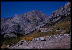
- Description:
- 50 f 10
- Subject:
- Rocks, Yosemite National Park (Calif.), Trees, Flowers, Volcanoes, Tioga Peak (Calif.), Mountains, and Shrubs
- Series:
- 9-54
- Creator:
- Cushman, Charles W., 1896-1972
- Date Created:
- 1954-09-16
- Genre:
- Landscape photographs
- Frame Number:
- 37
- Street Address:
- California State Highway 140
- County:
- Mono
- Abstract:
- Another view up toward Tioga Peak.
- Call Number:
- P07346
- Country:
- United States
- State/Province:
- California
- Physical Description:
- Image was originally mounted in a glass enclosure. Before digitization, the image was removed and placed in a Wess Plastic, Inc. brand, 2" x 2", pl...
- Alternate Identifier:
- 954.37
- Persistent URL:
- http://purl.dlib.indiana.edu/iudl/archives/cushman/P07346
- Holding Location:
- Bloomington - University Archives
Wells Library E460
1320 E 10th St.
Bloomington, IN 47405
Contact at archives@indiana.edu, 812-855-1127
-
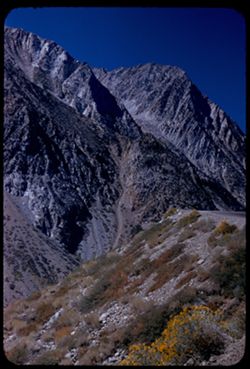
- Description:
- 50 f 9
- Subject:
- Passes (Landforms), Rocks, Mountains, Tioga Pass (Calif.), Yosemite Creek (Calif.), Dana Plateau (Calif.), Volcanoes, Shrubs, and Flowers
- Series:
- 9-54
- Creator:
- Cushman, Charles W., 1896-1972
- Date Created:
- 1954-09-16
- Genre:
- Landscape photographs
- Frame Number:
- 36
- County:
- Mono
- Abstract:
- Combs above south wall of Tioga Pass from N.
- Call Number:
- P07345
- Country:
- United States
- State/Province:
- California
- Alternate Identifier:
- 954.36
- Persistent URL:
- http://purl.dlib.indiana.edu/iudl/archives/cushman/P07345
- Holding Location:
- Bloomington - University Archives
Wells Library E460
1320 E 10th St.
Bloomington, IN 47405
Contact at archives@indiana.edu, 812-855-1127
-
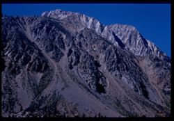
- Description:
- 50 f 9
- Subject:
- Dana Plateau (Calif.), Mountains, Yosemite National Park (Calif.), Shrubs, Tioga Pass (Calif.), and Volcanoes
- Series:
- 9-54
- Creator:
- Cushman, Charles W., 1896-1972
- Date Created:
- 1954-09-01
- Genre:
- Landscape photographs
- Frame Number:
- 35
- Street Address:
- California State Highway 140
- County:
- Mono
- Abstract:
- Combs above south wall of Tioga Pass from N.
- Call Number:
- P07344
- Country:
- United States
- State/Province:
- California
- Physical Description:
- Image was originally mounted in a glass enclosure. Before digitization, the image was removed and placed in a Wess Plastic, Inc. brand, 2" x 2", pl...
- Alternate Identifier:
- 954.35
- Persistent URL:
- http://purl.dlib.indiana.edu/iudl/archives/cushman/P07344
- Holding Location:
- Bloomington - University Archives
Wells Library E460
1320 E 10th St.
Bloomington, IN 47405
Contact at archives@indiana.edu, 812-855-1127
-
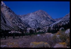
- Description:
- 50 f 10
- Subject:
- Lee Vining Creek (Calif.), Passes (Landforms), Flowers, Mountains, Shrubs, Trees, Rocks, and Tioga Pass (Calif.)
- Series:
- 9-54
- Creator:
- Cushman, Charles W., 1896-1972
- Date Created:
- 1954-09-16
- Genre:
- Landscape photographs
- Frame Number:
- 33
- Street Address:
- California State Highway 140
- County:
- Mono
- Abstract:
- Another look up toward Pass.
- Call Number:
- P07343
- Country:
- United States
- State/Province:
- California
- Physical Description:
- Image was originally mounted in a glass enclosure. Before digitization, the image was removed and placed in a Wess Plastic, Inc. brand, 2" x 2", pl...
- Alternate Identifier:
- 954.33
- Persistent URL:
- http://purl.dlib.indiana.edu/iudl/archives/cushman/P07343
- Holding Location:
- Bloomington - University Archives
Wells Library E460
1320 E 10th St.
Bloomington, IN 47405
Contact at archives@indiana.edu, 812-855-1127
-
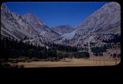
- Description:
- 50 f 10
- Subject:
- Yosemite National Park (Calif.), Trees, Volcanoes, Meadows, Lee Vining Creek (Calif.), Tioga Pass (Calif.), Mountains, Shrubs, and Passes (Landforms)
- Series:
- 9-54
- Creator:
- Cushman, Charles W., 1896-1972
- Date Created:
- 1954-09-16
- Genre:
- Landscape photographs
- Frame Number:
- 32
- County:
- Mono
- Abstract:
- View west toward Tioga Pass.
- Call Number:
- P07342
- Country:
- United States
- State/Province:
- California
- Physical Description:
- masked.
- Alternate Identifier:
- 954.32
- Persistent URL:
- http://purl.dlib.indiana.edu/iudl/archives/cushman/P07342
- Holding Location:
- Bloomington - University Archives
Wells Library E460
1320 E 10th St.
Bloomington, IN 47405
Contact at archives@indiana.edu, 812-855-1127
-
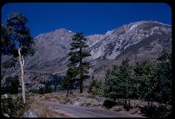
- Description:
- 50 f 9
- Subject:
- Rocks, Canyons, Grasses, Roads, Yosemite National Park (Calif.), Trees, Pines, Lee Vining Creek (Calif.), Tioga Peak (Calif.), Tioga Pass (Calif.), Mountains...
- Series:
- 9-54
- Creator:
- Cushman, Charles W., 1896-1972
- Date Created:
- 1954-09-16
- Genre:
- Landscape photographs
- Frame Number:
- 30
- Street Address:
- Tioga Pass Road
- County:
- Mono
- Abstract:
- Tioga Peak from east. 11,537 ft.
- Call Number:
- P07341
- Country:
- United States
- State/Province:
- California
- Alternate Identifier:
- 954.30
- Persistent URL:
- http://purl.dlib.indiana.edu/iudl/archives/cushman/P07341
- Holding Location:
- Bloomington - University Archives
Wells Library E460
1320 E 10th St.
Bloomington, IN 47405
Contact at archives@indiana.edu, 812-855-1127
-
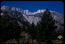
- Description:
- 50 f 9
- Subject:
- Dana Plateau (Calif.), Yosemite National Park (Calif.), Trees, Volcanoes, Dana, Mount (Calif.), Mountains, and Shrubs
- Series:
- 9-54
- Creator:
- Cushman, Charles W., 1896-1972
- Date Created:
- 1954-09-16
- Genre:
- Landscape photographs
- Frame Number:
- 29
- Street Address:
- Tioga Pass Road
- County:
- Mono
- Abstract:
- Top ridge of Mt Dana - last view from E.
- Call Number:
- P07340
- Country:
- United States
- State/Province:
- California
- Alternate Identifier:
- 954.29
- Persistent URL:
- http://purl.dlib.indiana.edu/iudl/archives/cushman/P07340
- Holding Location:
- Bloomington - University Archives
Wells Library E460
1320 E 10th St.
Bloomington, IN 47405
Contact at archives@indiana.edu, 812-855-1127
-
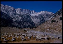
- Description:
- 50 f 10
- Subject:
- Sheep, Lee Vining Creek (Calif.), Deserts, Dana Plateau (Calif.), Roads, Mountains, Yosemite National Park (Calif.), Shrubs, Trees, Rocks, Grazing, Grasses, ...
- Series:
- 9-54
- Creator:
- Cushman, Charles W., 1896-1972
- Date Created:
- 1954-09-16
- Genre:
- Identification photographs
- Frame Number:
- 28
- Street Address:
- Tioga Pass Road
- County:
- Mono
- Abstract:
- Sheep along Tioga Pass road.
- Call Number:
- P07339
- Country:
- United States
- State/Province:
- California
- Physical Description:
- Image was originally mounted in a glass enclosure. Before digitization, the image was removed and placed in a Wess Plastic, Inc. brand, 2" x 2", pl...
- Alternate Identifier:
- 954.28
- Persistent URL:
- http://purl.dlib.indiana.edu/iudl/archives/cushman/P07339
- Holding Location:
- Bloomington - University Archives
Wells Library E460
1320 E 10th St.
Bloomington, IN 47405
Contact at archives@indiana.edu, 812-855-1127
-
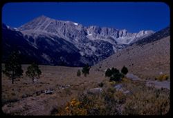
- Description:
- 50 f 10
- Subject:
- Lee Vining Creek (Calif.), Deserts, Flowers, Dana, Mount (Calif.), Dana Plateau (Calif.), Roads, Mountains, Yosemite National Park (Calif.), Shrubs, Trees, R...
- Series:
- 9-54
- Creator:
- Cushman, Charles W., 1896-1972
- Date Created:
- 1954-09-16
- Genre:
- Landscape photographs
- Frame Number:
- 27
- County:
- Mono
- Abstract:
- Great east wall of Mt. Dana.
- Call Number:
- P07338
- Country:
- United States
- State/Province:
- California
- Alternate Identifier:
- 954.27
- Persistent URL:
- http://purl.dlib.indiana.edu/iudl/archives/cushman/P07338
- Holding Location:
- Bloomington - University Archives
Wells Library E460
1320 E 10th St.
Bloomington, IN 47405
Contact at archives@indiana.edu, 812-855-1127
-
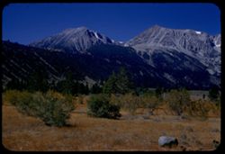
- Description:
- 50 f 9
- Subject:
- Rocks, Dana Plateau (Calif.), Grasses, Yosemite National Park (Calif.), Trees, Volcanoes, Gibbs, Mount (Calif.), Dana, Mount (Calif.), Mountains, and Shrubs
- Series:
- 9-54
- Creator:
- Cushman, Charles W., 1896-1972
- Date Created:
- 1954-09-16
- Genre:
- Landscape photographs
- Frame Number:
- 26
- Street Address:
- Tioga Pass Road
- County:
- Mono
- Abstract:
- Mt. Gibbs - to south of Dana.
- Call Number:
- P07337
- Country:
- United States
- State/Province:
- California
- Alternate Identifier:
- 954.26
- Persistent URL:
- http://purl.dlib.indiana.edu/iudl/archives/cushman/P07337
- Holding Location:
- Bloomington - University Archives
Wells Library E460
1320 E 10th St.
Bloomington, IN 47405
Contact at archives@indiana.edu, 812-855-1127
-
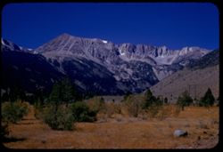
- Description:
- 50 f 11
- Subject:
- Dana, Mount (Calif.), Mountains, Yosemite National Park (Calif.), Shrubs, Trees, Rocks, Grasses, and Volcanoes
- Series:
- 9-54
- Creator:
- Cushman, Charles W., 1896-1972
- Date Created:
- 1954-09-16
- Genre:
- Landscape photographs
- Frame Number:
- 25
- Street Address:
- Tioga Pass Road
- County:
- Mono
- Abstract:
- Mt. Dana from east. (13,050 elev.)
- Call Number:
- P07336
- Country:
- United States
- State/Province:
- California
- Alternate Identifier:
- 954.25
- Persistent URL:
- http://purl.dlib.indiana.edu/iudl/archives/cushman/P07336
- Holding Location:
- Bloomington - University Archives
Wells Library E460
1320 E 10th St.
Bloomington, IN 47405
Contact at archives@indiana.edu, 812-855-1127
-
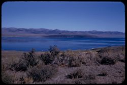
- Description:
- 50 f 9
- Subject:
- Bodies of water, Coastlines, Mountains, Shrubs, Lakes & ponds, Hills, and Mono Lake (Calif.)
- Series:
- 9-54
- Creator:
- Cushman, Charles W., 1896-1972
- Date Created:
- 1954-09-16
- Genre:
- Landscape photographs
- Frame Number:
- 24
- County:
- Mono
- Abstract:
- View across Mono Lake.
- Call Number:
- P07335
- Country:
- United States
- State/Province:
- California
- Alternate Identifier:
- 954.24
- Persistent URL:
- http://purl.dlib.indiana.edu/iudl/archives/cushman/P07335
- Holding Location:
- Bloomington - University Archives
Wells Library E460
1320 E 10th St.
Bloomington, IN 47405
Contact at archives@indiana.edu, 812-855-1127
-
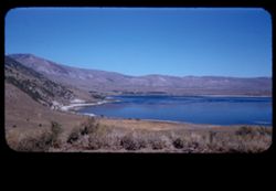
- Description:
- 50 f 11
- Subject:
- Bodies of water, Coastlines, Shrubs, Lakes & ponds, Hills, and Mono Lake (Calif.)
- Series:
- 9-54
- Creator:
- Cushman, Charles W., 1896-1972
- Date Created:
- 1954-09-16
- Genre:
- Landscape photographs
- Frame Number:
- 23
- County:
- Mono
- Abstract:
- View north across west end of Mono Lake.
- Call Number:
- P07334
- Country:
- United States
- State/Province:
- California
- Physical Description:
- masked.
- Alternate Identifier:
- 954.23
- Persistent URL:
- http://purl.dlib.indiana.edu/iudl/archives/cushman/P07334
- Holding Location:
- Bloomington - University Archives
Wells Library E460
1320 E 10th St.
Bloomington, IN 47405
Contact at archives@indiana.edu, 812-855-1127
-
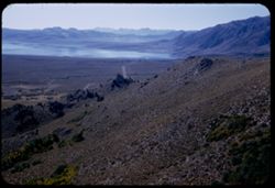
- Description:
- 50 f 8
- Subject:
- Bodies of water, Roads, Trees, Mountains, Shrubs, Lakes & ponds, Hills, and Mono Lake (Calif.)
- Series:
- 9-54
- Creator:
- Cushman, Charles W., 1896-1972
- Date Created:
- 1954-09-16
- Genre:
- Landscape photographs
- Frame Number:
- 22
- Street Address:
- United States Highway 395
- County:
- Mono
- Abstract:
- Looking down from north on west end of Mono Lake.
- Call Number:
- P07333
- Country:
- United States
- State/Province:
- California
- Alternate Identifier:
- 954.22
- Persistent URL:
- http://purl.dlib.indiana.edu/iudl/archives/cushman/P07333
- Holding Location:
- Bloomington - University Archives
Wells Library E460
1320 E 10th St.
Bloomington, IN 47405
Contact at archives@indiana.edu, 812-855-1127
-
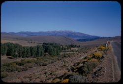
- Description:
- 50 f 11
- Subject:
- Deserts, Valleys, Trees, Flowers, Conway Summit (Calif.), Mountains, Shrubs, and Hills
- Series:
- 9-54
- Creator:
- Cushman, Charles W., 1896-1972
- Date Created:
- 1954-09-16
- Genre:
- Landscape photographs
- Frame Number:
- 21
- Street Address:
- United States Highway 395
- County:
- Mono
- Abstract:
- View north (w.) from US 395, 12 1/2 mi. so of Bridgeport. (19-20-21 were taken less than mile north of Conway Summit)
- Call Number:
- P07332
- City:
- Bridgeport
- Country:
- United States
- State/Province:
- California
- Alternate Identifier:
- 954.21
- Persistent URL:
- http://purl.dlib.indiana.edu/iudl/archives/cushman/P07332
- Holding Location:
- Bloomington - University Archives
Wells Library E460
1320 E 10th St.
Bloomington, IN 47405
Contact at archives@indiana.edu, 812-855-1127
-
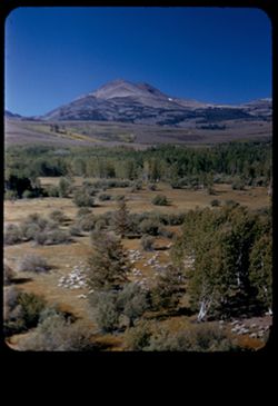
- Description:
- 50 f 9
- Subject:
- Sheep, Hills, Mountains, Shrubs, Sierra Nevada (Calif. and Nev.), Trees, Grazing, Grasses, and Dunderberg Peak (Calif.)
- Series:
- 9-54
- Creator:
- Cushman, Charles W., 1896-1972
- Date Created:
- 1954-09-16
- Genre:
- Landscape photographs
- Frame Number:
- 20
- Street Address:
- United States Highway 395
- County:
- Mono
- Abstract:
- Sheep below - looking toward Dunderberg Pk. (19-20-21 were taken less than mile north of Conway Summit)
- Call Number:
- P07331
- City:
- Bridgeport
- Country:
- United States
- State/Province:
- California
- Physical Description:
- masked.
- Alternate Identifier:
- 954.20
- Persistent URL:
- http://purl.dlib.indiana.edu/iudl/archives/cushman/P07331
- Holding Location:
- Bloomington - University Archives
Wells Library E460
1320 E 10th St.
Bloomington, IN 47405
Contact at archives@indiana.edu, 812-855-1127
-
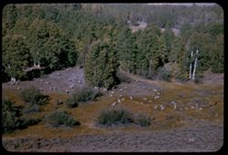
- Description:
- 50 f 9
- Subject:
- Grasses, Grazing, Trees, Conway Summit (Calif.), Mountains, Shrubs, Sheep, and Hills
- Series:
- 9-54
- Creator:
- Cushman, Charles W., 1896-1972
- Date Created:
- 1954-09-16
- Genre:
- Identification photographs
- Frame Number:
- 19
- Street Address:
- United States Highway 395
- County:
- Mono
- Abstract:
- Sheep below. (19-20-21 were taken less than mile north of Conway Summit)
- Call Number:
- P07330
- City:
- Bridgeport
- Country:
- United States
- State/Province:
- California
- Alternate Identifier:
- 954.19
- Persistent URL:
- http://purl.dlib.indiana.edu/iudl/archives/cushman/P07330
- Holding Location:
- Bloomington - University Archives
Wells Library E460
1320 E 10th St.
Bloomington, IN 47405
Contact at archives@indiana.edu, 812-855-1127
-
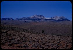
- Description:
- 50 f 11
- Subject:
- Trees, Mountains, Shrubs, Dunderberg Peak (Calif.), and Hills
- Series:
- 9-54
- Creator:
- Cushman, Charles W., 1896-1972
- Date Created:
- 1954-09-16
- Genre:
- Landscape photographs
- Frame Number:
- 18
- Street Address:
- United States Highway 395
- County:
- Mono
- Abstract:
- Dunderberg Pk., 12,368, from US 395, 8 1/2 mi. south of Bridgeport.
- Call Number:
- P07329
- City:
- Bridgeport
- Country:
- United States
- State/Province:
- California
- Alternate Identifier:
- 954.18
- Persistent URL:
- http://purl.dlib.indiana.edu/iudl/archives/cushman/P07329
- Holding Location:
- Bloomington - University Archives
Wells Library E460
1320 E 10th St.
Bloomington, IN 47405
Contact at archives@indiana.edu, 812-855-1127
-
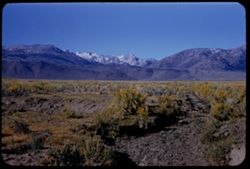
- Description:
- 50 f 11
- Subject:
- Sawtooth Ridge (Calif.), Twin Peaks (San Francisco County, Calif.), Dirt roads, Flowers, Matterhorn Peak (Calif.), Mountains, Shrubs, Sierra Nevada (Calif. a...
- Series:
- 9-54
- Creator:
- Cushman, Charles W., 1896-1972
- Date Created:
- 1954-09-16
- Genre:
- Landscape photographs
- Frame Number:
- 17
- Street Address:
- United States Highway 395
- County:
- Mono
- Abstract:
- Matterhorn and Twin Peaks from Hwy 395 to NE (?). Mountains of Sawtooth Ridge, all over, 11,000 ft.
- Call Number:
- P07328
- City:
- Bridgeport
- Country:
- United States
- State/Province:
- California
- Alternate Identifier:
- 954.17
- Persistent URL:
- http://purl.dlib.indiana.edu/iudl/archives/cushman/P07328
- Holding Location:
- Bloomington - University Archives
Wells Library E460
1320 E 10th St.
Bloomington, IN 47405
Contact at archives@indiana.edu, 812-855-1127