
Search Constraints
You searched for:
Campus
IUB
Remove constraint Campus: IUB
County
Monterey
Remove constraint County: Monterey
Pages
0-99 pages
Remove constraint Pages: 0-99 pages
State/Province
California
Remove constraint State/Province: California
« Previous |
1 - 100 of 122
|
Next »
Search Results
-
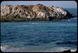
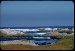
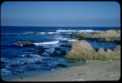
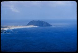
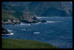
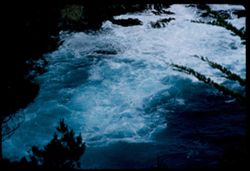
- Description:
- 50 f 6.3 sl hf
- Subject:
- Rocks, Oceans, Cliffs, Capes (Coasts), Beaches, Bixby Creek (Calif.), and Pacific Coast (Calif.)
- Series:
- 14-58
- Creator:
- Cushman, Charles W., 1896-1972
- Date Created:
- 1958-07-28
- Genre:
- Landscape photographs and Marine photographs
- Frame Number:
- 21
- County:
- Monterey
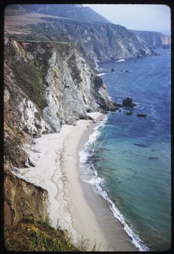
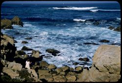
- Abstract:
- Coast at mouth of Bixby Creek
- Call Number:
- P10106
- Country:
- United States
- State/Province:
- California
- Alternate Identifier:
- 1458.21
- Persistent URL:
- http://purl.dlib.indiana.edu/iudl/archives/cushman/P10106
- Holding Location:
- Bloomington - University Archives
Wells Library E460
1320 E 10th St.
Bloomington, IN 47405
Contact at archives@indiana.edu, 812-855-1127
-
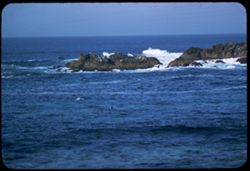
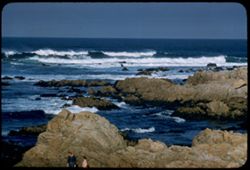
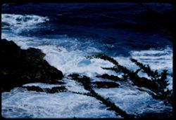
- Description:
- 50 f 6.3 sl hf
- Subject:
- Rocks, Oceans, Boulders, Capes (Coasts), Mountains, Sur, Point (Calif.), Mists, and Pacific Coast (Calif.)
- Series:
- 14-58
- Creator:
- Cushman, Charles W., 1896-1972
- Date Created:
- 1958-07-28
- Genre:
- Landscape photographs and Marine photographs
- Frame Number:
- 20
- County:
- Monterey
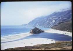
- Abstract:
- Coast near Pt. Sur
- Call Number:
- P10105
- Country:
- United States
- State/Province:
- California
- Alternate Identifier:
- 1458.20
- Persistent URL:
- http://purl.dlib.indiana.edu/iudl/archives/cushman/P10105
- Holding Location:
- Bloomington - University Archives
Wells Library E460
1320 E 10th St.
Bloomington, IN 47405
Contact at archives@indiana.edu, 812-855-1127
-
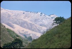
- Description:
- 100 f 8 tl
- Subject:
- Trees, Meadows, and Mountains
- Series:
- 8-58
- Creator:
- Cushman, Charles W., 1896-1972
- Date Created:
- 1958-05-01
- Genre:
- Landscape photographs
- Frame Number:
- 31
- Street Address:
- California State Highway 198
- County:
- Fresno and Monterey
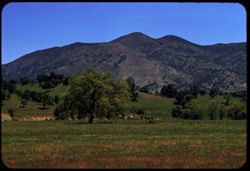
- Abstract:
- Mtn. Ridge east of 198 below Fresno-Monterey line
- Call Number:
- P09916
- Country:
- United States
- State/Province:
- California
- Alternate Identifier:
- 858.31
- Persistent URL:
- http://purl.dlib.indiana.edu/iudl/archives/cushman/P09916
- Holding Location:
- Bloomington - University Archives
Wells Library E460
1320 E 10th St.
Bloomington, IN 47405
Contact at archives@indiana.edu, 812-855-1127
-
- Description:
- 100 f 5.6 tl
- Subject:
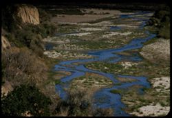
- Sandbars, Plains, Shrubs, Salinas River (Calif.), Streams, and Rivers
- Series:
- 18-57
- Creator:
- Cushman, Charles W., 1896-1972
- Date Created:
- 1957-12-02
- Genre:
- Landscape photographs
- Frame Number:
- 15
- County:
- Monterey
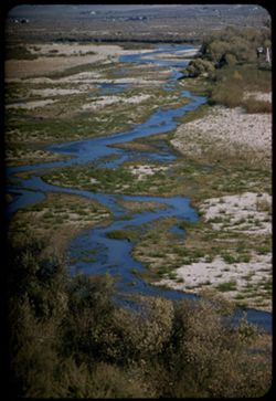
- Abstract:
- Salinas river between Bradley & San Ardo [P]
- Call Number:
- P09638
- City:
- San Ardo and Bradley
- Country:
- United States
- State/Province:
- California
- Alternate Identifier:
- 1857.15
- Persistent URL:
- http://purl.dlib.indiana.edu/iudl/archives/cushman/P09638
- Holding Location:
- Bloomington - University Archives
Wells Library E460
1320 E 10th St.
Bloomington, IN 47405
Contact at archives@indiana.edu, 812-855-1127
-
- Description:
- 100 f 6.3 tl
- Subject:
- Sandbars, Shrubs, Salinas River (Calif.), Streams, and Rivers
- Series:
- 18-57
- Creator:
- Cushman, Charles W., 1896-1972
- Date Created:
- 1957-12-02
- Genre:
- Landscape photographs
- Frame Number:
- 14
- County:
- Monterey
- Abstract:
- Salinas river between Bradley & San Ardo
- Call Number:
- P09637
- City:
- San Ardo and Bradley
- Country:
- United States
- State/Province:
- California
- Alternate Identifier:
- 1857.14
- Persistent URL:
- http://purl.dlib.indiana.edu/iudl/archives/cushman/P09637
- Holding Location:
- Bloomington - University Archives
Wells Library E460
1320 E 10th St.
Bloomington, IN 47405
Contact at archives@indiana.edu, 812-855-1127
-

- Description:
- 100 f 6.3 tl
- Subject:
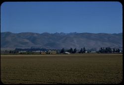
- Gabilan Range (Calif.), Trees, Croplands, Salinas River Valley (Calif.), and Mountains
- Series:
- 18-57
- Creator:
- Cushman, Charles W., 1896-1972
- Date Created:
- 1957-11-30
- Genre:
- Landscape photographs
- Frame Number:
- 3
- County:
- Monterey
- Abstract:
- Camel-shaped mountain of Gabilan Range SE of Soledad
- Call Number:
- P09626
- City:
- Soledad
- Country:
- United States
- State/Province:
- California
- Alternate Identifier:
- 1857.3
- Persistent URL:
- http://purl.dlib.indiana.edu/iudl/archives/cushman/P09626
- Holding Location:
- Bloomington - University Archives
Wells Library E460
1320 E 10th St.
Bloomington, IN 47405
Contact at archives@indiana.edu, 812-855-1127
-
- Description:
- 100 f 8 tl
- Subject:
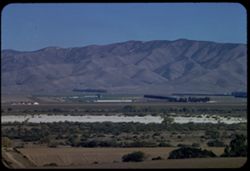
- Croplands, Valleys, Mountains, Agricultural facilities, Farms, Salinas River Valley (Calif.), and Pinnacles, The (Fresno County, Calif.)
- Series:
- 18-57
- Creator:
- Cushman, Charles W., 1896-1972
- Date Created:
- 1957-11-30
- Genre:
- Landscape photographs
- Frame Number:
- 2
- County:
- Monterey and Fresno
- Abstract:
- The Pinnacles - from point west of Soledad
- Call Number:
- P09625
- City:
- Soledad
- Country:
- United States
- State/Province:
- California
- Alternate Identifier:
- 1857.2
- Persistent URL:
- http://purl.dlib.indiana.edu/iudl/archives/cushman/P09625
- Holding Location:
- Bloomington - University Archives
Wells Library E460
1320 E 10th St.
Bloomington, IN 47405
Contact at archives@indiana.edu, 812-855-1127
-
- Description:
- 100 f 8 tl
- Subject:
- Valleys, Farms, Plains, Croplands, Shrubs, Salinas River Valley (Calif.), Mountains, and Agricultural facilities
- Series:
- 18-57
- Creator:
- Cushman, Charles W., 1896-1972
- Date Created:
- 1957-11-30
- Genre:
- Landscape photographs and Views
- Frame Number:
- 1
- County:
- Monterey
- Abstract:
- View NE across Salinas Valley between Gonzales & Soledad
- Call Number:
- P09624
- City:
- Soledad and Gonzales
- Country:
- United States
- State/Province:
- California
- Alternate Identifier:
- 1857.1
- Persistent URL:
- http://purl.dlib.indiana.edu/iudl/archives/cushman/P09624
- Holding Location:
- Bloomington - University Archives
Wells Library E460
1320 E 10th St.
Bloomington, IN 47405
Contact at archives@indiana.edu, 812-855-1127
-
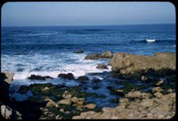
- Description:
- 100 f 5.6 tl
- Subject:
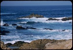
- Rocks, Oceans, Seas, Fan Shell Beach (Calif.), Pacific Ocean, Bird Rock (Monterey County, Calif.), Pacific Coast (Calif.), Islands, Seal Rock (Monterey Count...
- Series:
- 17-57
- Creator:
- Cushman, Charles W., 1896-1972
- Date Created:
- 1957-11-29
- Genre:
- Seascapes
- Frame Number:
- 21
- County:
- Monterey
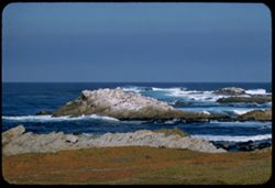
- Abstract:
- At Seal and Bird Rocks - Fan Shell Beach
- Call Number:
- P09623
- Country:
- United States
- State/Province:
- California
- Alternate Identifier:
- 1757.21
- Persistent URL:
- http://purl.dlib.indiana.edu/iudl/archives/cushman/P09623
- Holding Location:
- Bloomington - University Archives
Wells Library E460
1320 E 10th St.
Bloomington, IN 47405
Contact at archives@indiana.edu, 812-855-1127
-
- Description:
- 100 f 4.5 tl
- Subject:
- Seal Rock (Monterey County, Calif.), Oceans, Fan Shell Beach (Calif.), Birds, Monterey Peninsula (Calif.), Pacific Coast (Calif.), Islands, Seals (Animals), ...
- Series:
- 17-57
- Creator:
- Cushman, Charles W., 1896-1972
- Date Created:
- 1957-11-29
- Genre:
- Landscape photographs and Seascapes
- Frame Number:
- 20
- County:
- Monterey
- Abstract:
- At Seal and Bird Rocks - Fan Shell Beach
- Call Number:
- P09622
- Country:
- United States
- State/Province:
- California
- Alternate Identifier:
- 1757.20
- Persistent URL:
- http://purl.dlib.indiana.edu/iudl/archives/cushman/P09622
- Holding Location:
- Bloomington - University Archives
Wells Library E460
1320 E 10th St.
Bloomington, IN 47405
Contact at archives@indiana.edu, 812-855-1127
-
- Description:
- 100 f 4 tl
- Subject:
- Rocks, Oceans, Seas, Fan Shell Beach (Calif.), Pacific Ocean, Monterey Peninsula (Calif.), Pacific Coast (Calif.), Islands, Seals (Animals), Seal Rock (Monte...
- Series:
- 17-57
- Creator:
- Cushman, Charles W., 1896-1972
- Date Created:
- 1957-11-29
- Genre:
- Seascapes
- Frame Number:
- 19
- County:
- Monterey
- Abstract:
- At Seal and Bird Rocks - Fan Shell Beach
- Call Number:
- P09621
- Country:
- United States
- State/Province:
- California
- Alternate Identifier:
- 1757.19
- Persistent URL:
- http://purl.dlib.indiana.edu/iudl/archives/cushman/P09621
- Holding Location:
- Bloomington - University Archives
Wells Library E460
1320 E 10th St.
Bloomington, IN 47405
Contact at archives@indiana.edu, 812-855-1127
-
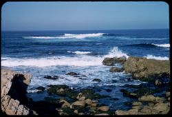
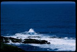
- Description:
- 100 f 4.5 sl
- Subject:
- Rocks, Oceans, Seas, Marine algae, Pacific Ocean, Monterey Peninsula (Calif.), Pacific Coast (Calif.), Point Joe (Calif.), and Seaweed
- Series:
- 17-57
- Creator:
- Cushman, Charles W., 1896-1972
- Date Created:
- 1957-11-29
- Genre:
- Seascapes
- Frame Number:
- 17
- County:
- Monterey
- Abstract:
- Surf at Point Joe
- Call Number:
- P09619
- Country:
- United States
- State/Province:
- California
- Alternate Identifier:
- 1757.17
- Persistent URL:
- http://purl.dlib.indiana.edu/iudl/archives/cushman/P09619
- Holding Location:
- Bloomington - University Archives
Wells Library E460
1320 E 10th St.
Bloomington, IN 47405
Contact at archives@indiana.edu, 812-855-1127
-
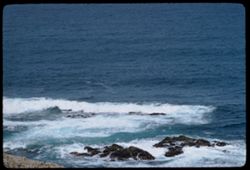
- Description:
- 100 f 4.5 sl
- Subject:
- Rocks, Oceans, Seas, Marine algae, Pacific Ocean, Capes (Coasts), Monterey Peninsula (Calif.), Pacific Coast (Calif.), Point Joe (Calif.), and Seaweed
- Series:
- 17-57
- Creator:
- Cushman, Charles W., 1896-1972
- Date Created:
- 1957-11-29
- Genre:
- Seascapes
- Frame Number:
- 18
- County:
- Monterey
- Abstract:
- Surf at Point Joe
- Call Number:
- P09620
- Country:
- United States
- State/Province:
- California
- Alternate Identifier:
- 1757.18
- Persistent URL:
- http://purl.dlib.indiana.edu/iudl/archives/cushman/P09620
- Holding Location:
- Bloomington - University Archives
Wells Library E460
1320 E 10th St.
Bloomington, IN 47405
Contact at archives@indiana.edu, 812-855-1127
-
- Description:
- 100 f 5.6 sl
- Subject:
- Rocks, Oceans, Seas, Cliffs, Pacific Ocean, Girls, Monterey Peninsula (Calif.), Pacific Coast (Calif.), and Point Joe (Calif.)
- Series:
- 17-57
- Creator:
- Cushman, Charles W., 1896-1972
- Date Created:
- 1957-11-29
- Genre:
- Seascapes
- Frame Number:
- 16
- County:
- Monterey
- Abstract:
- Surf at Point Joe
- Call Number:
- P09618
- Country:
- United States
- State/Province:
- California
- Alternate Identifier:
- 1757.16
- Persistent URL:
- http://purl.dlib.indiana.edu/iudl/archives/cushman/P09618
- Holding Location:
- Bloomington - University Archives
Wells Library E460
1320 E 10th St.
Bloomington, IN 47405
Contact at archives@indiana.edu, 812-855-1127
-
- Description:
- 100 f 6.3 tl
- Subject:
- Rocks, Oceans, Seas, Pacific Ocean, Monterey Peninsula (Calif.), Point Pinos (Calif.), and Pacific Coast (Calif.)
- Series:
- 17-57
- Creator:
- Cushman, Charles W., 1896-1972
- Date Created:
- 1957-11-28
- Genre:
- Seascapes
- Frame Number:
- 15
- County:
- Monterey
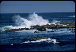
- Abstract:
- High surf near Pt. Pinos
- Call Number:
- P09617
- Country:
- United States
- State/Province:
- California
- Alternate Identifier:
- 1757.15
- Persistent URL:
- http://purl.dlib.indiana.edu/iudl/archives/cushman/P09617
- Holding Location:
- Bloomington - University Archives
Wells Library E460
1320 E 10th St.
Bloomington, IN 47405
Contact at archives@indiana.edu, 812-855-1127
-
- Description:
- 100 f 6.3 tl
- Subject:
- Rocks, Oceans, Seas, Pacific Ocean, Monterey Peninsula (Calif.), Point Pinos (Calif.), and Pacific Coast (Calif.)
- Series:
- 17-57
- Creator:
- Cushman, Charles W., 1896-1972
- Date Created:
- 1957-11-28
- Genre:
- Seascapes
- Frame Number:
- 14
- County:
- Monterey
- Abstract:
- High surf near Pt. Pinos
- Call Number:
- P09616
- Country:
- United States
- State/Province:
- California
- Alternate Identifier:
- 1757.14
- Persistent URL:
- http://purl.dlib.indiana.edu/iudl/archives/cushman/P09616
- Holding Location:
- Bloomington - University Archives
Wells Library E460
1320 E 10th St.
Bloomington, IN 47405
Contact at archives@indiana.edu, 812-855-1127
-
- Description:
- 100 f 6.3 tl
- Subject:
- Point Pinos (Calif.), Pacific Ocean, Pacific Coast (Calif.), Oceans, Islands, Seas, Rocks, Monterey Peninsula (Calif.), and Bird Rock (Monterey County, Calif.)
- Series:
- 17-57
- Creator:
- Cushman, Charles W., 1896-1972
- Date Created:
- 1957-11-28
- Genre:
- Seascapes
- Frame Number:
- 12
- County:
- Monterey
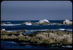
- Abstract:
- Surf around bird rocks near Pt. Pinos
- Call Number:
- P09614
- Country:
- United States
- State/Province:
- California
- Alternate Identifier:
- 1757.12
- Persistent URL:
- http://purl.dlib.indiana.edu/iudl/archives/cushman/P09614
- Holding Location:
- Bloomington - University Archives
Wells Library E460
1320 E 10th St.
Bloomington, IN 47405
Contact at archives@indiana.edu, 812-855-1127
-
- Description:
- 100 f 6.3 tl
- Subject:
- Rocks, Oceans, Seas, Pacific Ocean, Bird Rock (Monterey County, Calif.), Point Pinos (Calif.), Pacific Coast (Calif.), Islands, and Monterey Peninsula (Calif.)
- Series:
- 17-57
- Creator:
- Cushman, Charles W., 1896-1972
- Date Created:
- 1957-11-28
- Genre:
- Seascapes
- Frame Number:
- 13
- County:
- Monterey
- Abstract:
- Surf around bird rocks near Pt. Pinos
- Call Number:
- P09615
- Country:
- United States
- State/Province:
- California
- Alternate Identifier:
- 1757.13
- Persistent URL:
- http://purl.dlib.indiana.edu/iudl/archives/cushman/P09615
- Holding Location:
- Bloomington - University Archives
Wells Library E460
1320 E 10th St.
Bloomington, IN 47405
Contact at archives@indiana.edu, 812-855-1127
-
- Description:
- 100 f 6.3 tl
- Subject:
- Point Pinos (Calif.), Pacific Ocean, Pacific Coast (Calif.), Rocks, Seas, People, Oceans, and Monterey Peninsula (Calif.)
- Series:
- 17-57
- Creator:
- Cushman, Charles W., 1896-1972
- Date Created:
- 1957-11-28
- Genre:
- Seascapes
- Frame Number:
- 11
- Street Address:
- Sunset Drive
- County:
- Monterey
- Abstract:
- Rollers off Sunset Dr. near Pt. Pinos
- Call Number:
- P09613
- Country:
- United States
- State/Province:
- California
- Alternate Identifier:
- 1757.11
- Persistent URL:
- http://purl.dlib.indiana.edu/iudl/archives/cushman/P09613
- Holding Location:
- Bloomington - University Archives
Wells Library E460
1320 E 10th St.
Bloomington, IN 47405
Contact at archives@indiana.edu, 812-855-1127
-
- Description:
- 100 f 6.3 tl
- Subject:
- Point Pinos (Calif.), Pacific Ocean, Pacific Coast (Calif.), Oceans, Seas, Rocks, and Monterey Peninsula (Calif.)
- Series:
- 17-57
- Creator:
- Cushman, Charles W., 1896-1972
- Date Created:
- 1957-11-28
- Genre:
- Seascapes
- Frame Number:
- 10
- Street Address:
- Sunset Drive
- County:
- Monterey
- Abstract:
- Rollers off Sunset Dr. near Pt. Pinos
- Call Number:
- P09612
- Country:
- United States
- State/Province:
- California
- Alternate Identifier:
- 1757.10
- Persistent URL:
- http://purl.dlib.indiana.edu/iudl/archives/cushman/P09612
- Holding Location:
- Bloomington - University Archives
Wells Library E460
1320 E 10th St.
Bloomington, IN 47405
Contact at archives@indiana.edu, 812-855-1127
-
- Description:
- 100 f 5.6 sl
- Subject:
- Point Pinos (Calif.), Men, Pacific Ocean, Pacific Coast (Calif.), Walking, Monterey Peninsula (Calif.), Beaches, Seas, Rocks, and Oceans
- Series:
- 17-57
- Creator:
- Cushman, Charles W., 1896-1972
- Date Created:
- 1957-11-28
- Genre:
- Seascapes
- Frame Number:
- 9
- Street Address:
- Sunset Drive
- County:
- Monterey
- Abstract:
- Surf along Sunset Dr. near Pt. Pinos
- Call Number:
- P09611
- Country:
- United States
- State/Province:
- California
- Alternate Identifier:
- 1757.9
- Persistent URL:
- http://purl.dlib.indiana.edu/iudl/archives/cushman/P09611
- Holding Location:
- Bloomington - University Archives
Wells Library E460
1320 E 10th St.
Bloomington, IN 47405
Contact at archives@indiana.edu, 812-855-1127
-
- Description:
- 100 f 5.6 sl
- Subject:
- Rocks, Oceans, Seas, Pacific Ocean, Monterey Peninsula (Calif.), Point Pinos (Calif.), Beaches, and Pacific Coast (Calif.)
- Series:
- 17-57
- Creator:
- Cushman, Charles W., 1896-1972
- Date Created:
- 1957-11-28
- Genre:
- Seascapes
- Frame Number:
- 8
- Street Address:
- Sunset Drive
- County:
- Monterey
- Abstract:
- Surf along Sunset Dr. near Pt. Pinos
- Call Number:
- P09610
- Country:
- United States
- State/Province:
- California
- Alternate Identifier:
- 1757.8
- Persistent URL:
- http://purl.dlib.indiana.edu/iudl/archives/cushman/P09610
- Holding Location:
- Bloomington - University Archives
Wells Library E460
1320 E 10th St.
Bloomington, IN 47405
Contact at archives@indiana.edu, 812-855-1127
-
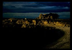
- Description:
- 100 f 6.3 tl probably taken at 1/50 in error ?
- Subject:
- Canyons, Kirk Creek (Calif.), Mountains, and Hills
- Series:
- 15-57
- Creator:
- Cushman, Charles W., 1896-1972
- Date Created:
- 1957-09-22
- Genre:
- Landscape photographs
- Frame Number:
- 18
- Street Address:
- California State Highway 1 and Pacific Coast Highway
- County:
- Monterey
- Abstract:
- Hump above Kirk Creek back of Cal 1
- Call Number:
- P09549
- Country:
- United States
- State/Province:
- California
- Alternate Identifier:
- 1557.18
- Persistent URL:
- http://purl.dlib.indiana.edu/iudl/archives/cushman/P09549
- Holding Location:
- Bloomington - University Archives
Wells Library E460
1320 E 10th St.
Bloomington, IN 47405
Contact at archives@indiana.edu, 812-855-1127
-
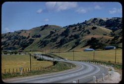
- Description:
- 100 f 6.3 tl
- Subject:
- Roads, Automobiles, Meadows, Fences, Hills, and Utility poles
- Series:
- 6-57
- Creator:
- Cushman, Charles W., 1896-1972
- Date Created:
- 1957-05-10
- Genre:
- Landscape photographs
- Frame Number:
- 17
- Street Address:
- United States Highway 101
- County:
- Monterey
- Abstract:
- Southern US 101 south of San Ardo
- Call Number:
- P09259
- City:
- San Ardo
- Country:
- United States
- State/Province:
- California
- Alternate Identifier:
- 657.17
- Persistent URL:
- http://purl.dlib.indiana.edu/iudl/archives/cushman/P09259
- Holding Location:
- Bloomington - University Archives
Wells Library E460
1320 E 10th St.
Bloomington, IN 47405
Contact at archives@indiana.edu, 812-855-1127
-
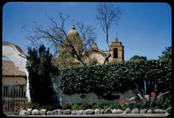
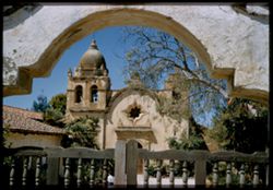
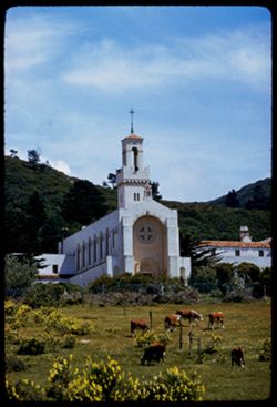
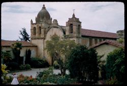
- Description:
- 50 f 8 sl
- Subject:
- Walls, Mission churches, Missions, Adobe buildings, Trees, Arches, Catholic churches, Domes, Gates, Bell towers, Crosses, Historic buildings, and Mission San...
- Series:
- 6-57
- Creator:
- Cushman, Charles W., 1896-1972
- Date Created:
- 1957-05-10
- Genre:
- Architectural photographs
- Frame Number:
- 16
- County:
- Monterey
- Abstract:
- Mission of San Carlos Borromeo del Carmelo - across wall
- Call Number:
- P09258
- City:
- Carmel
- Country:
- United States
- State/Province:
- California
- Alternate Identifier:
- 657.16
- Persistent URL:
- http://purl.dlib.indiana.edu/iudl/archives/cushman/P09258
- Holding Location:
- Bloomington - University Archives
Wells Library E460
1320 E 10th St.
Bloomington, IN 47405
Contact at archives@indiana.edu, 812-855-1127
-
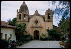
- Description:
- 50 f 7 sl
- Subject:
- Bell towers, Missions, Adobe buildings, Mission San Carlos Borromeo (Carmel, Calif.), Catholic churches, Domes, Gates, Courtyards, Mission churches, Historic...
- Series:
- 6-57
- Creator:
- Cushman, Charles W., 1896-1972
- Date Created:
- 1957-05-10
- Genre:
- Architectural photographs
- Frame Number:
- 15
- County:
- Monterey
- Abstract:
- Mission of San Carlos Borromeo del Carmelo through gate
- Call Number:
- P09257
- City:
- Carmel
- Country:
- United States
- State/Province:
- California
- Physical Description:
- Image was originally mounted in a glass enclosure. Before digitization, the image was removed and placed in a Wess Plastic, Inc. brand, 2" x 2", pl...
- Alternate Identifier:
- 657.15
- Persistent URL:
- http://purl.dlib.indiana.edu/iudl/archives/cushman/P09257
- Holding Location:
- Bloomington - University Archives
Wells Library E460
1320 E 10th St.
Bloomington, IN 47405
Contact at archives@indiana.edu, 812-855-1127
-
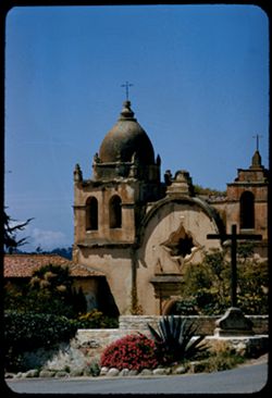
- Description:
- 100 f 6.3 tl
- Subject:
- Crosses, Historic buildings, Adobe buildings, Mission San Carlos Borromeo (Carmel, Calif.), Catholic churches, Domes, Bell towers, Mission churches, Missions...
- Series:
- 6-57
- Creator:
- Cushman, Charles W., 1896-1972
- Date Created:
- 1957-05-10
- Genre:
- Architectural photographs
- Frame Number:
- 14
- County:
- Monterey
- Abstract:
- Mission-San Carlos Borromeo
- Call Number:
- P09256
- City:
- Carmel
- Country:
- United States
- State/Province:
- California
- Alternate Identifier:
- 657.14
- Persistent URL:
- http://purl.dlib.indiana.edu/iudl/archives/cushman/P09256
- Holding Location:
- Bloomington - University Archives
Wells Library E460
1320 E 10th St.
Bloomington, IN 47405
Contact at archives@indiana.edu, 812-855-1127
-
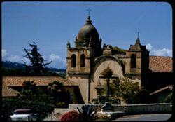
- Description:
- 100 f 6.3
- Subject:
- Bell towers, Missions, Automobiles, Mission San Carlos Borromeo (Carmel, Calif.), Catholic churches, Domes, Mission churches, Crosses, Historic buildings, Ad...
- Series:
- 6-57
- Creator:
- Cushman, Charles W., 1896-1972
- Date Created:
- 1957-05-10
- Genre:
- Architectural photographs
- Frame Number:
- 13
- County:
- Monterey
- Abstract:
- Mission-San Carlos Borromeo
- Call Number:
- P09255
- City:
- Carmel
- Country:
- United States
- State/Province:
- California
- Alternate Identifier:
- 657.13
- Persistent URL:
- http://purl.dlib.indiana.edu/iudl/archives/cushman/P09255
- Holding Location:
- Bloomington - University Archives
Wells Library E460
1320 E 10th St.
Bloomington, IN 47405
Contact at archives@indiana.edu, 812-855-1127
-
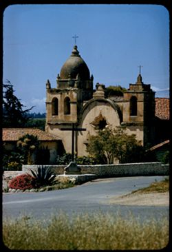
- Description:
- 100 f 6.3 tl
- Subject:
- Domes, Crosses, Missions, Mission churches, Arches, Roads, Catholic churches, Bell towers, Historic buildings, Adobe buildings, and Mission San Carlos Borrom...
- Series:
- 6-57
- Creator:
- Cushman, Charles W., 1896-1972
- Date Created:
- 1957-05-10
- Genre:
- Architectural photographs
- Frame Number:
- 12
- County:
- Monterey
- Abstract:
- Mission-San Carlos Borromeo
- Call Number:
- P09254
- City:
- Carmel
- Country:
- United States
- State/Province:
- California
- Alternate Identifier:
- 657.12
- Persistent URL:
- http://purl.dlib.indiana.edu/iudl/archives/cushman/P09254
- Holding Location:
- Bloomington - University Archives
Wells Library E460
1320 E 10th St.
Bloomington, IN 47405
Contact at archives@indiana.edu, 812-855-1127
-
- Description:
- 100 f 6.3 tl
- Subject:
- Women, Rocks, Beaches, Seas, Buildings, and Oceans
- Series:
- 6-57
- Creator:
- Cushman, Charles W., 1896-1972
- Date Created:
- 1957-05-10
- Genre:
- Seascapes and Views
- Frame Number:
- 11
- County:
- Monterey
- Abstract:
- Surf & rocks
- Call Number:
- P09253
- City:
- Carmel
- Country:
- United States
- State/Province:
- California
- Alternate Identifier:
- 657.11
- Persistent URL:
- http://purl.dlib.indiana.edu/iudl/archives/cushman/P09253
- Holding Location:
- Bloomington - University Archives
Wells Library E460
1320 E 10th St.
Bloomington, IN 47405
Contact at archives@indiana.edu, 812-855-1127
-
- Description:
- 100 f 6.3 tl
- Subject:
- Rocks, Oceans, Seas, Marine algae, Beaches, Children playing in sand, and Seaweed
- Series:
- 6-57
- Creator:
- Cushman, Charles W., 1896-1972
- Date Created:
- 1957-05-10
- Genre:
- Seascapes
- Frame Number:
- 10
- County:
- Monterey
- Abstract:
- Surf & rocks-Carmel
- Call Number:
- P09252
- City:
- Carmel
- Country:
- United States
- State/Province:
- California
- Alternate Identifier:
- 657.10
- Persistent URL:
- http://purl.dlib.indiana.edu/iudl/archives/cushman/P09252
- Holding Location:
- Bloomington - University Archives
Wells Library E460
1320 E 10th St.
Bloomington, IN 47405
Contact at archives@indiana.edu, 812-855-1127
-
- Description:
- 100 f 8 tl
- Subject:
- Oceans, Seas, Coastlines, Beaches, Children playing in sand, and People
- Series:
- 6-57
- Creator:
- Cushman, Charles W., 1896-1972
- Date Created:
- 1957-05-10
- Genre:
- Landscape photographs and Seascapes
- Frame Number:
- 9
- County:
- Monterey
- Abstract:
- Carmel Beach
- Call Number:
- P09251
- City:
- Carmel
- Country:
- United States
- State/Province:
- California
- Alternate Identifier:
- 657.9
- Persistent URL:
- http://purl.dlib.indiana.edu/iudl/archives/cushman/P09251
- Holding Location:
- Bloomington - University Archives
Wells Library E460
1320 E 10th St.
Bloomington, IN 47405
Contact at archives@indiana.edu, 812-855-1127
-
- Description:
- 100 f 8 tl
- Subject:
- Oceans, Seas, Women, Coastlines, Beaches, and Children playing in sand
- Series:
- 6-57
- Creator:
- Cushman, Charles W., 1896-1972
- Date Created:
- 1957-05-10
- Genre:
- Landscape photographs and Seascapes
- Frame Number:
- 8
- County:
- Monterey
- Abstract:
- Carmel Beach
- Call Number:
- P09250
- City:
- Carmel
- Country:
- United States
- State/Province:
- California
- Alternate Identifier:
- 657.8
- Persistent URL:
- http://purl.dlib.indiana.edu/iudl/archives/cushman/P09250
- Holding Location:
- Bloomington - University Archives
Wells Library E460
1320 E 10th St.
Bloomington, IN 47405
Contact at archives@indiana.edu, 812-855-1127
-
- Description:
- 100 f 8 tl
- Subject:
- Oceans, Seas, Women, Coastlines, Beaches, and Children playing in sand
- Series:
- 6-57
- Creator:
- Cushman, Charles W., 1896-1972
- Date Created:
- 1957-05-10
- Genre:
- Landscape photographs and Seascapes
- Frame Number:
- 7
- County:
- Monterey
- Abstract:
- Carmel Beach
- Call Number:
- P09249
- City:
- Carmel
- Country:
- United States
- State/Province:
- California
- Alternate Identifier:
- 657.7
- Persistent URL:
- http://purl.dlib.indiana.edu/iudl/archives/cushman/P09249
- Holding Location:
- Bloomington - University Archives
Wells Library E460
1320 E 10th St.
Bloomington, IN 47405
Contact at archives@indiana.edu, 812-855-1127
-
- Description:
- 100 f 5.6 tl
- Subject:
- Crosses, Historic buildings, Royal Presidio Chapel (Monterey, Calif.), Forts & fortifications, Adobe buildings, Arches, Catholic churches, Churches, and ...
- Series:
- 6-57
- Creator:
- Cushman, Charles W., 1896-1972
- Date Created:
- 1957-05-10
- Genre:
- Architectural photographs
- Frame Number:
- 6
- Street Address:
- 550 Church Street
- County:
- Monterey
- Abstract:
- Presidio Chapel of San Carlos de Barromeo
- Call Number:
- P09248
- City:
- Monterey
- Country:
- United States
- State/Province:
- California
- Alternate Identifier:
- 657.6
- Persistent URL:
- http://purl.dlib.indiana.edu/iudl/archives/cushman/P09248
- Holding Location:
- Bloomington - University Archives
Wells Library E460
1320 E 10th St.
Bloomington, IN 47405
Contact at archives@indiana.edu, 812-855-1127
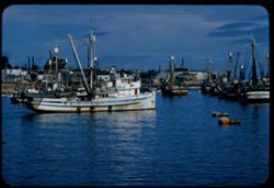
-
- Description:
- 100 f 8 tl
- Subject:
- Piers & wharves, Forts & fortifications, Fishing boats, Monterey Bay (Calif.), Presidio of Monterey (Calif.), Harbors, and Buildings
- Series:
- 6-57
- Creator:
- Cushman, Charles W., 1896-1972
- Date Created:
- 1957-05-10
- Genre:
- Marine photographs
- Frame Number:
- 5
- County:
- Monterey
- Abstract:
- Presidio from wharf
- Call Number:
- P09247
- City:
- Monterey
- Country:
- United States
- State/Province:
- California
- Alternate Identifier:
- 657.5
- Persistent URL:
- http://purl.dlib.indiana.edu/iudl/archives/cushman/P09247
- Holding Location:
- Bloomington - University Archives
Wells Library E460
1320 E 10th St.
Bloomington, IN 47405
Contact at archives@indiana.edu, 812-855-1127
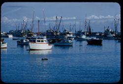
-
- Description:
- 100 f 8 tl
- Subject:
- Fishing boats, Boats, Monterey Bay (Calif.), Harbors, Rowboats, and Buildings
- Series:
- 6-57
- Creator:
- Cushman, Charles W., 1896-1972
- Date Created:
- 1957-05-10
- Genre:
- Marine photographs
- Frame Number:
- 4
- County:
- Monterey
- Abstract:
- Fishing boats in Monterey Harbor
- Call Number:
- P09246
- City:
- Monterey
- Country:
- United States
- State/Province:
- California
- Physical Description:
- Image was originally mounted in a glass enclosure. Before digitization, the image was removed and placed in a Wess Plastic, Inc. brand, 2" x 2", pl...
- Alternate Identifier:
- 657.4
- Persistent URL:
- http://purl.dlib.indiana.edu/iudl/archives/cushman/P09246
- Holding Location:
- Bloomington - University Archives
Wells Library E460
1320 E 10th St.
Bloomington, IN 47405
Contact at archives@indiana.edu, 812-855-1127
-
- Description:
- 100 f 8 tl
- Subject:
- Fishing boats, Monterey Bay (Calif.), and Harbors
- Series:
- 6-57
- Creator:
- Cushman, Charles W., 1896-1972
- Date Created:
- 1957-05-10
- Genre:
- Marine photographs
- Frame Number:
- 3
- County:
- Monterey
- Abstract:
- Fishing boats in Monetrey Harbor
- Call Number:
- P09245
- City:
- Monterey
- Country:
- United States
- State/Province:
- California
- Alternate Identifier:
- 657.3
- Persistent URL:
- http://purl.dlib.indiana.edu/iudl/archives/cushman/P09245
- Holding Location:
- Bloomington - University Archives
Wells Library E460
1320 E 10th St.
Bloomington, IN 47405
Contact at archives@indiana.edu, 812-855-1127
-
- Description:
- 100 f 5.6 tl
- Subject:
- Harbors, Monterey Bay (Calif.), and Fishing boats
- Series:
- 6-57
- Creator:
- Cushman, Charles W., 1896-1972
- Date Created:
- 1957-05-10
- Genre:
- Marine photographs
- Frame Number:
- 2
- County:
- Monterey
- Abstract:
- Harbor-Monterey
- Call Number:
- P09244
- City:
- Monterey
- Country:
- United States
- State/Province:
- California
- Alternate Identifier:
- 657.2
- Persistent URL:
- http://purl.dlib.indiana.edu/iudl/archives/cushman/P09244
- Holding Location:
- Bloomington - University Archives
Wells Library E460
1320 E 10th St.
Bloomington, IN 47405
Contact at archives@indiana.edu, 812-855-1127
-
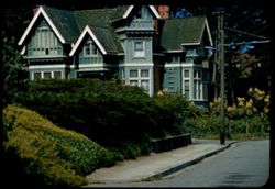
- Description:
- 100 f 6.3 tl
- Subject:
- Houses, Cornices, Gables, Sidewalks, Shrubs, Windows, and Utility poles
- Series:
- 6-57
- Creator:
- Cushman, Charles W., 1896-1972
- Date Created:
- 1957-05-10
- Genre:
- Architectural photographs
- Frame Number:
- 1
- Street Address:
- Fifth Street and Ocean View Boulevard
- County:
- Monterey
- Abstract:
- Old green house-Pacific Grove (5th & Ocean View)
- Call Number:
- P09243
- City:
- Pacific Grove
- Country:
- United States
- State/Province:
- California
- Alternate Identifier:
- 657.1
- Persistent URL:
- http://purl.dlib.indiana.edu/iudl/archives/cushman/P09243
- Holding Location:
- Bloomington - University Archives
Wells Library E460
1320 E 10th St.
Bloomington, IN 47405
Contact at archives@indiana.edu, 812-855-1127
-

- Description:
- 100 f 8 tl
- Subject:
- Bays (Bodies of water), Piers & wharves, Electric lines, Monterey Bay (Calif.), Pacific Coast (Calif.), Wooden buildings, and Utility poles
- Series:
- 5-57
- Creator:
- Cushman, Charles W., 1896-1972
- Date Created:
- 1957-05-09
- Genre:
- Marine photographs and Architectural photographs
- Frame Number:
- 37
- County:
- Monterey
- Abstract:
- The Wharf-Monterey
- Call Number:
- P09242
- City:
- Monterey
- Country:
- United States
- State/Province:
- California
- Alternate Identifier:
- 557.37
- Persistent URL:
- http://purl.dlib.indiana.edu/iudl/archives/cushman/P09242
- Holding Location:
- Bloomington - University Archives
Wells Library E460
1320 E 10th St.
Bloomington, IN 47405
Contact at archives@indiana.edu, 812-855-1127
-
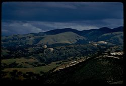
- Description:
- 100 f 8 tl
- Subject:
- Valleys, Laureles Grade (Calif.), Meadows, Mountains, Clouds, and Hills
- Series:
- 5-57
- Creator:
- Cushman, Charles W., 1896-1972
- Date Created:
- 1957-05-09
- Genre:
- Landscape photographs
- Frame Number:
- 36
- County:
- Monterey
- Abstract:
- Mountains to NE from Laureles Grade
- Call Number:
- P09241
- Country:
- United States
- State/Province:
- California
- Alternate Identifier:
- 557.36
- Persistent URL:
- http://purl.dlib.indiana.edu/iudl/archives/cushman/P09241
- Holding Location:
- Bloomington - University Archives
Wells Library E460
1320 E 10th St.
Bloomington, IN 47405
Contact at archives@indiana.edu, 812-855-1127
-
- Description:
- 100 f 8 tl
- Subject:
- Barns, Valleys, Farmhouses, Laureles Grade (Calif.), Outbuildings, Farms, Mountains, Clouds, and Antennas (Electronics)
- Series:
- 5-57
- Creator:
- Cushman, Charles W., 1896-1972
- Date Created:
- 1957-05-09
- Genre:
- Landscape photographs and Views
- Frame Number:
- 35
- County:
- Monterey
- Abstract:
- Mountains to NE from Laureles Grade
- Call Number:
- P09240
- Country:
- United States
- State/Province:
- California
- Alternate Identifier:
- 557.35
- Persistent URL:
- http://purl.dlib.indiana.edu/iudl/archives/cushman/P09240
- Holding Location:
- Bloomington - University Archives
Wells Library E460
1320 E 10th St.
Bloomington, IN 47405
Contact at archives@indiana.edu, 812-855-1127
-
- Description:
- 100 f 6.3 tl
- Subject:
- Barns, Valleys, Roads, Farms, Trees, Meadows, and Carmel Valley (Calif. : Valley)
- Series:
- 5-57
- Creator:
- Cushman, Charles W., 1896-1972
- Date Created:
- 1957-05-09
- Genre:
- Landscape photographs
- Frame Number:
- 34
- County:
- Monterey
- Abstract:
- Farm scene-Carmel Valley
- Call Number:
- P09239
- City:
- Carmel Valley
- Country:
- United States
- State/Province:
- California
- Alternate Identifier:
- 557.34
- Persistent URL:
- http://purl.dlib.indiana.edu/iudl/archives/cushman/P09239
- Holding Location:
- Bloomington - University Archives
Wells Library E460
1320 E 10th St.
Bloomington, IN 47405
Contact at archives@indiana.edu, 812-855-1127
-
- Description:
- 100 f 5.6 tl
- Subject:
- Valleys, Trees, Mountains, Carmel Valley (Calif. : Valley), and Forests
- Series:
- 5-57
- Creator:
- Cushman, Charles W., 1896-1972
- Date Created:
- 1957-05-09
- Genre:
- Landscape photographs and Views
- Frame Number:
- 33
- County:
- Monterey
- Abstract:
- Carmel Valley from hieght on NW
- Call Number:
- P09238
- City:
- Carmel Valley
- Country:
- United States
- State/Province:
- California
- Alternate Identifier:
- 557.33
- Persistent URL:
- http://purl.dlib.indiana.edu/iudl/archives/cushman/P09238
- Holding Location:
- Bloomington - University Archives
Wells Library E460
1320 E 10th St.
Bloomington, IN 47405
Contact at archives@indiana.edu, 812-855-1127
-
- Description:
- 100 f 6.3
- Subject:
- Grazing, Meadows, Cattle, Carmel Valley (Calif. : Valley), Hills, and Livestock
- Series:
- 5-57
- Creator:
- Cushman, Charles W., 1896-1972
- Date Created:
- 1957-05-09
- Genre:
- Landscape photographs
- Frame Number:
- 32
- County:
- Monterey
- Abstract:
- Green hill above Carmel Valley
- Call Number:
- P09237
- City:
- Carmel Valley
- Country:
- United States
- State/Province:
- California
- Alternate Identifier:
- 557.32
- Persistent URL:
- http://purl.dlib.indiana.edu/iudl/archives/cushman/P09237
- Holding Location:
- Bloomington - University Archives
Wells Library E460
1320 E 10th St.
Bloomington, IN 47405
Contact at archives@indiana.edu, 812-855-1127
-
- Description:
- 100 f 5.6 tl
- Subject:
- Barns, Valleys, Meadows, Mountains, Carmel Valley (Calif. : Valley), and Hills
- Series:
- 5-57
- Creator:
- Cushman, Charles W., 1896-1972
- Date Created:
- 1957-05-09
- Genre:
- Landscape photographs
- Frame Number:
- 31
- County:
- Monterey
- Abstract:
- View up the Carmel Valley
- Call Number:
- P09236
- Country:
- United States
- State/Province:
- California
- Alternate Identifier:
- 557.31
- Persistent URL:
- http://purl.dlib.indiana.edu/iudl/archives/cushman/P09236
- Holding Location:
- Bloomington - University Archives
Wells Library E460
1320 E 10th St.
Bloomington, IN 47405
Contact at archives@indiana.edu, 812-855-1127
-
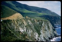
- Description:
- 100 f 6.3 tl
- Subject:
- Oceans, Coastlines, Pacific Ocean, Meadows, Clouds, Pacific Coast (Calif.), and Sur, Point (Calif.)
- Series:
- 5-57
- Creator:
- Cushman, Charles W., 1896-1972
- Date Created:
- 1957-05-09
- Genre:
- Landscape photographs
- Frame Number:
- 30
- County:
- Monterey
- Abstract:
- Bank of Clouds above coast south of Pt Sur
- Call Number:
- P09235
- Country:
- United States
- State/Province:
- California
- Alternate Identifier:
- 557.30
- Persistent URL:
- http://purl.dlib.indiana.edu/iudl/archives/cushman/P09235
- Holding Location:
- Bloomington - University Archives
Wells Library E460
1320 E 10th St.
Bloomington, IN 47405
Contact at archives@indiana.edu, 812-855-1127
-
- Description:
- 100 f 6.3 tl
- Subject:
- Oceans, Seas, Coastlines, Pacific Ocean, Mountains, Beaches, Rock formations, Sur, Point (Calif.), and Pacific Coast (Calif.)
- Series:
- 5-57
- Creator:
- Cushman, Charles W., 1896-1972
- Date Created:
- 1957-05-09
- Genre:
- Landscape photographs
- Frame Number:
- 29
- County:
- Monterey
- Abstract:
- Beach below
- Call Number:
- P09234
- Country:
- United States
- State/Province:
- California
- Alternate Identifier:
- 557.29
- Persistent URL:
- http://purl.dlib.indiana.edu/iudl/archives/cushman/P09234
- Holding Location:
- Bloomington - University Archives
Wells Library E460
1320 E 10th St.
Bloomington, IN 47405
Contact at archives@indiana.edu, 812-855-1127
-
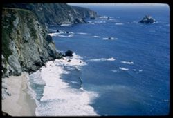
- Description:
- 100 f 6.3 tl
- Subject:
- Oceans, Seas, Cliffs, Coastlines, Pacific Ocean, Mountains, Beaches, Pacific Coast (Calif.), and Sur, Point (Calif.)
- Series:
- 5-57
- Creator:
- Cushman, Charles W., 1896-1972
- Date Created:
- 1957-05-09
- Genre:
- Landscape photographs
- Frame Number:
- 28
- County:
- Monterey
- Abstract:
- Green Velvet at Point Sur
- Call Number:
- P09233
- Country:
- United States
- State/Province:
- California
- Alternate Identifier:
- 557.28
- Persistent URL:
- http://purl.dlib.indiana.edu/iudl/archives/cushman/P09233
- Holding Location:
- Bloomington - University Archives
Wells Library E460
1320 E 10th St.
Bloomington, IN 47405
Contact at archives@indiana.edu, 812-855-1127
-
- Description:
- 100 f 6.3 tl
- Subject:
- Seas, Coastlines, Capes (Coasts), Beaches, Rock formations, and Sur, Point (Calif.)
- Series:
- 5-57
- Creator:
- Cushman, Charles W., 1896-1972
- Date Created:
- 1957-05-09
- Genre:
- Seascapes
- Frame Number:
- 27
- County:
- Monterey
- Abstract:
- Point Sur
- Call Number:
- P09232
- Country:
- United States
- State/Province:
- California
- Alternate Identifier:
- 557.27
- Persistent URL:
- http://purl.dlib.indiana.edu/iudl/archives/cushman/P09232
- Holding Location:
- Bloomington - University Archives
Wells Library E460
1320 E 10th St.
Bloomington, IN 47405
Contact at archives@indiana.edu, 812-855-1127
-
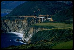
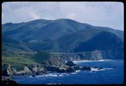
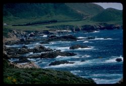
- Description:
- 100 f 6.3 tl
- Subject:
- Bays (Bodies of water), Oceans, Seas, Cliffs, Coastlines, Pacific Ocean, Bixby Bridge (Calif.), Pacific Coast (Calif.), Bixby Creek (Calif.), and Bridges
- Series:
- 5-57
- Creator:
- Cushman, Charles W., 1896-1972
- Date Created:
- 1957-05-09
- Genre:
- Landscape photographs
- Frame Number:
- 26
- County:
- Monterey
- Abstract:
- Mouth of Bixby Creek from south
- Call Number:
- P09231
- Country:
- United States
- State/Province:
- California
- Alternate Identifier:
- 557.26
- Persistent URL:
- http://purl.dlib.indiana.edu/iudl/archives/cushman/P09231
- Holding Location:
- Bloomington - University Archives
Wells Library E460
1320 E 10th St.
Bloomington, IN 47405
Contact at archives@indiana.edu, 812-855-1127
-
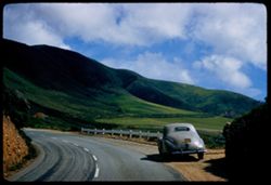
- Description:
- 100 f 5.6 sl
- Subject:
- Railings, Zephyr automobile, Roads, Automobiles, Lincoln Zephyr, Meadows, Mountains, Bixby Creek (Calif.), and Hills
- Series:
- 5-57
- Creator:
- Cushman, Charles W., 1896-1972
- Date Created:
- 1957-05-09
- Genre:
- Landscape photographs and Snapshots
- Frame Number:
- 25
- Street Address:
- California Highway 1 and Pacific Coast Highway
- County:
- Monterey
- Abstract:
- LZ & others south of Bixby Creek
- Call Number:
- P09230
- Country:
- United States
- State/Province:
- California
- Alternate Identifier:
- 557.25
- Persistent URL:
- http://purl.dlib.indiana.edu/iudl/archives/cushman/P09230
- Holding Location:
- Bloomington - University Archives
Wells Library E460
1320 E 10th St.
Bloomington, IN 47405
Contact at archives@indiana.edu, 812-855-1127
-
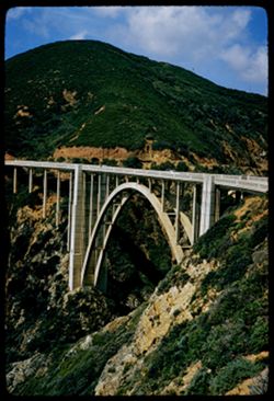
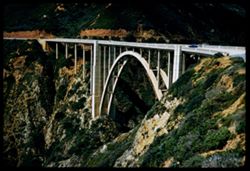
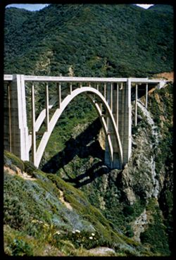
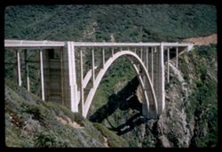
- Description:
- 100 f 6.3 sl
- Subject:
- Canyons, Arches, Mountains, Bixby Creek (Calif.), Bridges, and Bixby Bridge (Calif.)
- Series:
- 5-57
- Creator:
- Cushman, Charles W., 1896-1972
- Date Created:
- 1957-05-09
- Genre:
- Views and Architectural photographs
- Frame Number:
- 24
- Street Address:
- California Highway 1 and Pacific Coast Highway
- County:
- Monterey
- Abstract:
- Bixby Creek concrete arch bridge from south [P]
- Call Number:
- P09229
- Country:
- United States
- State/Province:
- California
- Alternate Identifier:
- 557.24
- Persistent URL:
- http://purl.dlib.indiana.edu/iudl/archives/cushman/P09229
- Holding Location:
- Bloomington - University Archives
Wells Library E460
1320 E 10th St.
Bloomington, IN 47405
Contact at archives@indiana.edu, 812-855-1127
-
- Description:
- 100 f 5.6 sl
- Subject:
- Canyons, Arches, Bixby Creek (Calif.), Bridges, and Bixby Bridge (Calif.)
- Series:
- 5-57
- Creator:
- Cushman, Charles W., 1896-1972
- Date Created:
- 1957-05-09
- Genre:
- Views and Architectural photographs
- Frame Number:
- 23
- Street Address:
- California State Highway 1 and Pacific Coast Highway
- County:
- Monterey
- Abstract:
- Bixby Creek concrete arch bridge from south [L]
- Call Number:
- P09228
- Country:
- United States
- State/Province:
- California
- Alternate Identifier:
- 557.23
- Persistent URL:
- http://purl.dlib.indiana.edu/iudl/archives/cushman/P09228
- Holding Location:
- Bloomington - University Archives
Wells Library E460
1320 E 10th St.
Bloomington, IN 47405
Contact at archives@indiana.edu, 812-855-1127
-
- Description:
- 100 f 4 sl
- Subject:
- Oceans, Seas, Cliffs, Pacific Ocean, Mountains, Bixby Creek (Calif.), Pacific Coast (Calif.), and Hills
- Series:
- 5-57
- Creator:
- Cushman, Charles W., 1896-1972
- Date Created:
- 1957-05-09
- Genre:
- Landscape photographs
- Frame Number:
- 22
- County:
- Monterey
- Abstract:
- Green slopes above
- Call Number:
- P09227
- Country:
- United States
- State/Province:
- California
- Alternate Identifier:
- 557.22
- Persistent URL:
- http://purl.dlib.indiana.edu/iudl/archives/cushman/P09227
- Holding Location:
- Bloomington - University Archives
Wells Library E460
1320 E 10th St.
Bloomington, IN 47405
Contact at archives@indiana.edu, 812-855-1127
-
- Description:
- 100 f 4 sl
- Subject:
- Cliffs, Pacific Ocean, Pacific Coast (Calif.), Rocks, Coastlines, Beaches, Islands, Seas, Bixby Creek (Calif.), and Oceans
- Series:
- 5-57
- Creator:
- Cushman, Charles W., 1896-1972
- Date Created:
- 1957-05-09
- Genre:
- Seascapes
- Frame Number:
- 21
- County:
- Monterey
- Abstract:
- Ocean near mouth of Bixby Creek
- Call Number:
- P09226
- Country:
- United States
- State/Province:
- California
- Alternate Identifier:
- 557.21
- Persistent URL:
- http://purl.dlib.indiana.edu/iudl/archives/cushman/P09226
- Holding Location:
- Bloomington - University Archives
Wells Library E460
1320 E 10th St.
Bloomington, IN 47405
Contact at archives@indiana.edu, 812-855-1127
-
- Description:
- 100 f 4 sl
- Subject:
- Canyons, Arches, Mountains, Bixby Bridge (Calif.), Bridges, Hills, and Bixby Creek (Calif.)
- Series:
- 5-57
- Creator:
- Cushman, Charles W., 1896-1972
- Date Created:
- 1957-05-09
- Genre:
- Architectural photographs
- Frame Number:
- 20
- Street Address:
- California Highway 1 and Pacific Coast Highway
- County:
- Monterey
- Abstract:
- Bixby Creek Concrete Arch Bridge [P]
- Call Number:
- P09225
- Country:
- United States
- State/Province:
- California
- Alternate Identifier:
- 557.20
- Persistent URL:
- http://purl.dlib.indiana.edu/iudl/archives/cushman/P09225
- Holding Location:
- Bloomington - University Archives
Wells Library E460
1320 E 10th St.
Bloomington, IN 47405
Contact at archives@indiana.edu, 812-855-1127
-
- Description:
- 50 f 5.6 sl
- Subject:
- Canyons, Arches, Bixby Creek (Calif.), Bridges, and Bixby Bridge (Calif.)
- Series:
- 5-57
- Creator:
- Cushman, Charles W., 1896-1972
- Date Created:
- 1957-05-09
- Genre:
- Architectural photographs
- Frame Number:
- 19
- Street Address:
- SR-1 and Pacific Coast Highway
- County:
- Monterey
- Abstract:
- Bixby Creek Concrete Arch Bridge [L]
- Call Number:
- P09224
- Country:
- United States
- State/Province:
- California
- Alternate Identifier:
- 557.19
- Persistent URL:
- http://purl.dlib.indiana.edu/iudl/archives/cushman/P09224
- Holding Location:
- Bloomington - University Archives
Wells Library E460
1320 E 10th St.
Bloomington, IN 47405
Contact at archives@indiana.edu, 812-855-1127
-
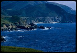
- Description:
- 100 f 5.6 tl
- Subject:
- Rocks, Bays (Bodies of water), Oceans, Seas, Cliffs, Coastlines, Pacific Ocean, Arches, Mountains, Rock formations, Bridges, Rocky Creek (Monterey County, Ca...
- Series:
- 5-57
- Creator:
- Cushman, Charles W., 1896-1972
- Date Created:
- 1957-05-09
- Genre:
- Landscape photographs and Seascapes
- Frame Number:
- 18
- County:
- Monterey
- Abstract:
- Cove between Rocky Pt and Rocky Creek
- Call Number:
- P09223
- Country:
- United States
- State/Province:
- California
- Alternate Identifier:
- 557.18
- Persistent URL:
- http://purl.dlib.indiana.edu/iudl/archives/cushman/P09223
- Holding Location:
- Bloomington - University Archives
Wells Library E460
1320 E 10th St.
Bloomington, IN 47405
Contact at archives@indiana.edu, 812-855-1127
-
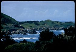
- Description:
- 100 f 5.6 tl
- Subject:
- Rocks, Oceans, Seas, Cliffs, Coastlines, Pacific Ocean, Arches, Mountains, Rock formations, Bridges, Rocky Point (Monterey County, Calif.), Rocky Creek Bridg...
- Series:
- 5-57
- Creator:
- Cushman, Charles W., 1896-1972
- Date Created:
- 1957-05-09
- Genre:
- Landscape photographs
- Frame Number:
- 17
- County:
- Monterey
- Abstract:
- Green Mt. back of Rocky Ck. bridge
- Call Number:
- P09222
- Country:
- United States
- State/Province:
- California
- Alternate Identifier:
- 557.17
- Persistent URL:
- http://purl.dlib.indiana.edu/iudl/archives/cushman/P09222
- Holding Location:
- Bloomington - University Archives
Wells Library E460
1320 E 10th St.
Bloomington, IN 47405
Contact at archives@indiana.edu, 812-855-1127
-
- Description:
- 100 f 6.3 tl
- Subject:
- Rocky Creek Bridge (Monterey County, Calif.), Arches, Cliffs, Bridges, Mountains, Oceans, Coastlines, Soberanes Point (Calif.), Rock formations, Seas, Rocks,...
- Series:
- 5-57
- Creator:
- Cushman, Charles W., 1896-1972
- Date Created:
- 1957-05-09
- Genre:
- Seascapes and Landscape photographs
- Frame Number:
- 16
- County:
- Monterey
- Abstract:
- Rocky Creek bridge from Rocky Point
- Call Number:
- P09221
- Country:
- United States
- State/Province:
- California
- Alternate Identifier:
- 557.16
- Persistent URL:
- http://purl.dlib.indiana.edu/iudl/archives/cushman/P09221
- Holding Location:
- Bloomington - University Archives
Wells Library E460
1320 E 10th St.
Bloomington, IN 47405
Contact at archives@indiana.edu, 812-855-1127
-
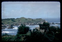
- Description:
- 100 f 6.3 tl
- Subject:
- Rocks, Oceans, Soberanes Point (Calif.), Coastlines, Pacific Ocean, Mountains, Pacific Coast (Calif.), and Garrapata Creek (Monterey County, Calif.)
- Series:
- 5-57
- Creator:
- Cushman, Charles W., 1896-1972
- Date Created:
- 1957-05-09
- Genre:
- Landscape photographs and Seascapes
- Frame Number:
- 15
- County:
- Monterey
- Abstract:
- Coast north of Garrapata Creek
- Call Number:
- P09220
- City:
- Carmel
- Country:
- United States
- State/Province:
- California
- Alternate Identifier:
- 557.15
- Persistent URL:
- http://purl.dlib.indiana.edu/iudl/archives/cushman/P09220
- Holding Location:
- Bloomington - University Archives
Wells Library E460
1320 E 10th St.
Bloomington, IN 47405
Contact at archives@indiana.edu, 812-855-1127
-
- Description:
- 100 f 6.3 tl
- Subject:
- Garrapata Creek (Monterey County, Calif.), Cliffs, Pacific Ocean, Mountains, Pacific Coast (Calif.), Oceans, Coastlines, Soberanes Point (Calif.), and Clouds
- Series:
- 5-57
- Creator:
- Cushman, Charles W., 1896-1972
- Date Created:
- 1957-05-09
- Genre:
- Landscape photographs
- Frame Number:
- 14
- County:
- Monterey
- Abstract:
- Rocky headland at Garrapata Creek
- Call Number:
- P09219
- City:
- Carmel
- Country:
- United States
- State/Province:
- California
- Alternate Identifier:
- 557.14
- Persistent URL:
- http://purl.dlib.indiana.edu/iudl/archives/cushman/P09219
- Holding Location:
- Bloomington - University Archives
Wells Library E460
1320 E 10th St.
Bloomington, IN 47405
Contact at archives@indiana.edu, 812-855-1127
-
- Description:
- 100 f 8 tl
- Subject:
- Oceans, Seas, Cliffs, Kasler Point (Calif.), Coastlines, Pacific Ocean, Beaches, Pacific Coast (Calif.), and Hills
- Series:
- 5-57
- Creator:
- Cushman, Charles W., 1896-1972
- Date Created:
- 1957-05-09
- Genre:
- Landscape photographs and Seascapes
- Frame Number:
- 13
- County:
- Monterey
- Abstract:
- Beach near Kasler Pt. at Garrapata Creek
- Call Number:
- P09218
- City:
- Garrapata Creek
- Country:
- United States
- State/Province:
- California
- Alternate Identifier:
- 557.13
- Persistent URL:
- http://purl.dlib.indiana.edu/iudl/archives/cushman/P09218
- Holding Location:
- Bloomington - University Archives
Wells Library E460
1320 E 10th St.
Bloomington, IN 47405
Contact at archives@indiana.edu, 812-855-1127
-
- Description:
- 100 f 6.3 tl
- Subject:
- Rocks, Oceans, Soberanes Point (Calif.), Cliffs, Coastlines, Pacific Ocean, Pacific Coast (Calif.), Hills, and Seas
- Series:
- 5-57
- Creator:
- Cushman, Charles W., 1896-1972
- Date Created:
- 1957-05-09
- Genre:
- Landscape photographs
- Frame Number:
- 12
- County:
- Monterey
- Abstract:
- Coast a few miles south of Carmel Bay near Soberanes Pt.
- Call Number:
- P09217
- City:
- Carmel
- Country:
- United States
- State/Province:
- California
- Alternate Identifier:
- 557.12
- Persistent URL:
- http://purl.dlib.indiana.edu/iudl/archives/cushman/P09217
- Holding Location:
- Bloomington - University Archives
Wells Library E460
1320 E 10th St.
Bloomington, IN 47405
Contact at archives@indiana.edu, 812-855-1127
-
- Description:
- 100 f 5.6 tl
- Subject:
- Bell towers, Monasteries, Grazing, Carmelite Monastery, Meadows, Flowering shrubs, Cattle, Catholic churches, Churches, Hills, Bull's eye windows, Crosse...
- Series:
- 5-57
- Creator:
- Cushman, Charles W., 1896-1972
- Date Created:
- 1957-05-09
- Genre:
- Architectural photographs
- Frame Number:
- 10
- County:
- Monterey
- Abstract:
- Carmelite Monastery on Carmel Bay
- Call Number:
- P09215
- City:
- Carmel
- Country:
- United States
- State/Province:
- California
- Alternate Identifier:
- 557.10
- Persistent URL:
- http://purl.dlib.indiana.edu/iudl/archives/cushman/P09215
- Holding Location:
- Bloomington - University Archives
Wells Library E460
1320 E 10th St.
Bloomington, IN 47405
Contact at archives@indiana.edu, 812-855-1127
-
- Description:
- 100 f 5.6 tl
- Subject:
- Rocks, Oceans, Soberanes Point (Calif.), Cliffs, Coastlines, Pacific Ocean, Pacific Coast (Calif.), Hills, and Seas
- Series:
- 5-57
- Creator:
- Cushman, Charles W., 1896-1972
- Date Created:
- 1957-05-09
- Genre:
- Landscape photographs and Seascapes
- Frame Number:
- 11
- County:
- Monterey
- Abstract:
- Coast a few miles south of Carmel Bay near Soberanes Pt.
- Call Number:
- P09216
- City:
- Carmel
- Country:
- United States
- State/Province:
- California
- Alternate Identifier:
- 557.11
- Persistent URL:
- http://purl.dlib.indiana.edu/iudl/archives/cushman/P09216
- Holding Location:
- Bloomington - University Archives
Wells Library E460
1320 E 10th St.
Bloomington, IN 47405
Contact at archives@indiana.edu, 812-855-1127
-
- Description:
- 100 f 5.6
- Subject:
- Rocks, Bays (Bodies of water), Oceans, Seas, Antennas (Electronics), Cliffs, Highlands Inn (Carmel, Calif.), Pacific Ocean, Pacific Coast (Calif.), Hills, an...
- Series:
- 5-57
- Creator:
- Cushman, Charles W., 1896-1972
- Date Created:
- 1957-05-09
- Genre:
- Landscape photographs and Seascapes
- Frame Number:
- 9
- County:
- Monterey
- Abstract:
- Cove southwest of Highlands Inn
- Call Number:
- P09214
- City:
- Carmel
- Country:
- United States
- State/Province:
- California
- Alternate Identifier:
- 557.9
- Persistent URL:
- http://purl.dlib.indiana.edu/iudl/archives/cushman/P09214
- Holding Location:
- Bloomington - University Archives
Wells Library E460
1320 E 10th St.
Bloomington, IN 47405
Contact at archives@indiana.edu, 812-855-1127
-
- Description:
- 100 f 6.3
- Subject:
- Rocks, Bays (Bodies of water), Oceans, Seas, Cliffs, Highlands Inn (Carmel, Calif.), Pacific Ocean, Pacific Coast (Calif.), Hills, and Carmel Highlands (Calif.)
- Series:
- 5-57
- Creator:
- Cushman, Charles W., 1896-1972
- Date Created:
- 1957-05-09
- Genre:
- Landscape photographs
- Frame Number:
- 8
- County:
- Monterey
- Abstract:
- Cove southwest of Highlands Inn
- Call Number:
- P09213
- City:
- Carmel
- Country:
- United States
- State/Province:
- California
- Alternate Identifier:
- 557.8
- Persistent URL:
- http://purl.dlib.indiana.edu/iudl/archives/cushman/P09213
- Holding Location:
- Bloomington - University Archives
Wells Library E460
1320 E 10th St.
Bloomington, IN 47405
Contact at archives@indiana.edu, 812-855-1127
-
- Description:
- 100 f 8 tl
- Subject:
- Rocks, Oceans, Seas, Pacific Ocean, Mission San Carlos Borromeo (Carmel, Calif.), Tree limbs, Pacific Coast (Calif.), and Carmel Highlands (Calif.)
- Series:
- 5-57
- Creator:
- Cushman, Charles W., 1896-1972
- Date Created:
- 1957-05-09
- Genre:
- Seascapes
- Frame Number:
- 7
- County:
- Monterey
- Abstract:
- Mission San Carlos Borromeo
- Call Number:
- P09212
- City:
- Carmel
- Country:
- United States
- State/Province:
- California
- Alternate Identifier:
- 557.7
- Persistent URL:
- http://purl.dlib.indiana.edu/iudl/archives/cushman/P09212
- Holding Location:
- Bloomington - University Archives
Wells Library E460
1320 E 10th St.
Bloomington, IN 47405
Contact at archives@indiana.edu, 812-855-1127
-
- Description:
- 100 f 8 tl
- Subject:
- Rocks, Oceans, Seas, Pacific Ocean, Mission San Carlos Borromeo (Carmel, Calif.), Tree limbs, Pacific Coast (Calif.), and Carmel Highlands (Calif.)
- Series:
- 5-57
- Creator:
- Cushman, Charles W., 1896-1972
- Date Created:
- 1957-05-09
- Genre:
- Seascapes
- Frame Number:
- 6
- County:
- Monterey
- Abstract:
- Mission San Carlos Borromeo
- Call Number:
- P09211
- City:
- Carmel
- Country:
- United States
- State/Province:
- California
- Alternate Identifier:
- 557.6
- Persistent URL:
- http://purl.dlib.indiana.edu/iudl/archives/cushman/P09211
- Holding Location:
- Bloomington - University Archives
Wells Library E460
1320 E 10th St.
Bloomington, IN 47405
Contact at archives@indiana.edu, 812-855-1127
-
- Description:
- 100 f 8 tl
- Subject:
- Rocks, Oceans, Seas, Pacific Ocean, Mission San Carlos Borromeo (Carmel, Calif.), Pacific Coast (Calif.), and Carmel Highlands (Calif.)
- Series:
- 5-57
- Creator:
- Cushman, Charles W., 1896-1972
- Date Created:
- 1957-05-09
- Genre:
- Seascapes
- Frame Number:
- 5
- County:
- Monterey
- Abstract:
- Mission San Carlos Borromeo
- Call Number:
- P09210
- City:
- Carmel
- Country:
- United States
- State/Province:
- California
- Alternate Identifier:
- 557.5
- Persistent URL:
- http://purl.dlib.indiana.edu/iudl/archives/cushman/P09210
- Holding Location:
- Bloomington - University Archives
Wells Library E460
1320 E 10th St.
Bloomington, IN 47405
Contact at archives@indiana.edu, 812-855-1127
-
- Description:
- 100 f 8 tl
- Subject:
- Pacific Ocean, Pacific Coast (Calif.), Rocks, Seas, Carmel Highlands (Calif.), and Oceans
- Series:
- 5-57
- Creator:
- Cushman, Charles W., 1896-1972
- Date Created:
- 1957-05-09
- Genre:
- Seascapes
- Frame Number:
- 4
- County:
- Monterey
- Abstract:
- Surf below Carmel Highlands
- Call Number:
- P09209
- City:
- Carmel
- Country:
- United States
- State/Province:
- California
- Alternate Identifier:
- 557.4
- Persistent URL:
- http://purl.dlib.indiana.edu/iudl/archives/cushman/P09209
- Holding Location:
- Bloomington - University Archives
Wells Library E460
1320 E 10th St.
Bloomington, IN 47405
Contact at archives@indiana.edu, 812-855-1127
-
- Description:
- 50 f 5.6 sl
- Subject:
- Bell towers, Missions, Women, Adobe buildings, Gardens, Arches, Catholic churches, Domes, Courtyards, Mission churches, Crosses, Historic buildings, and Miss...
- Series:
- 5-57
- Creator:
- Cushman, Charles W., 1896-1972
- Date Created:
- 1957-05-09
- Genre:
- Architectural photographs
- Frame Number:
- 3
- County:
- Monterey
- Abstract:
- Mission San Carlos Borromeo
- Call Number:
- P09208
- City:
- Carmel
- Country:
- United States
- State/Province:
- California
- Alternate Identifier:
- 557.3
- Persistent URL:
- http://purl.dlib.indiana.edu/iudl/archives/cushman/P09208
- Holding Location:
- Bloomington - University Archives
Wells Library E460
1320 E 10th St.
Bloomington, IN 47405
Contact at archives@indiana.edu, 812-855-1127
-
- Description:
- 50 f 5.6 sl
- Subject:
- Courtyards, Missions, Adobe buildings, Mission San Carlos Borromeo (Carmel, Calif.), Catholic churches, Domes, Doors & doorways, Bell towers, Mission chu...
- Series:
- 5-57
- Creator:
- Cushman, Charles W., 1896-1972
- Date Created:
- 1957-05-09
- Genre:
- Architectural photographs
- Frame Number:
- 2
- County:
- Monterey
- Abstract:
- Mission San Carlos Borromeo
- Call Number:
- P09207
- City:
- Carmel
- Country:
- United States
- State/Province:
- California
- Alternate Identifier:
- 557.2
- Persistent URL:
- http://purl.dlib.indiana.edu/iudl/archives/cushman/P09207
- Holding Location:
- Bloomington - University Archives
Wells Library E460
1320 E 10th St.
Bloomington, IN 47405
Contact at archives@indiana.edu, 812-855-1127
-
- Description:
- 100 f 5.6 sl
- Subject:
- Rocks, Bays (Bodies of water), Cliffs, Monterey Bay (Calif.), Beaches, Rock formations, Clouds, Sunrises & sunsets, and Pacific Coast (Calif.)
- Series:
- 5-57
- Creator:
- Cushman, Charles W., 1896-1972
- Date Created:
- 1957-05-08
- Genre:
- Landscape photographs
- Frame Number:
- 1
- County:
- Monterey
- Abstract:
- Cove at Pacific Grove evening sun
- Call Number:
- P09206
- City:
- Pacific Grove and Monterey
- Country:
- United States
- State/Province:
- California
- Physical Description:
- Image was originally mounted in a glass enclosure. Before digitization, the image was removed and placed in a Wess Plastic, Inc. brand, 2" x 2", pl...
- Alternate Identifier:
- 557.1
- Persistent URL:
- http://purl.dlib.indiana.edu/iudl/archives/cushman/P09206
- Holding Location:
- Bloomington - University Archives
Wells Library E460
1320 E 10th St.
Bloomington, IN 47405
Contact at archives@indiana.edu, 812-855-1127
-
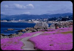
- Description:
- 100 f 6.3 tl
- Subject:
- Meadows, Cities & towns, Flowers, Monterey Bay (Calif.), Mountains, Waterfronts, Families, Rocks, Coastlines, Ice plant, Walkways, Bays (Bodies of water)...
- Series:
- 4-57
- Creator:
- Cushman, Charles W., 1896-1972
- Date Created:
- 1957-05-08
- Genre:
- Identification photographs, Seascapes, and Views
- Frame Number:
- 21
- County:
- Monterey
- Abstract:
- Ice plant along Monterey Bay at Pacific Grove
- Call Number:
- P09205
- City:
- Pacific Grove
- Country:
- United States
- State/Province:
- California
- Alternate Identifier:
- 457.21
- Persistent URL:
- http://purl.dlib.indiana.edu/iudl/archives/cushman/P09205
- Holding Location:
- Bloomington - University Archives
Wells Library E460
1320 E 10th St.
Bloomington, IN 47405
Contact at archives@indiana.edu, 812-855-1127
-
- Description:
- 100 f 6.3 TL
- Subject:
- Bull Canyon (Monterey County, Calif.), Valleys, Hills, Farmhouses, San Lorenzo Creek (Calif.), Trees, Farms, and Streams
- Series:
- 6-56
- Creator:
- Cushman, Charles W., 1896-1972
- Date Created:
- 1956-04-21
- Genre:
- Landscape photographs
- Frame Number:
- 7
- County:
- Monterey
- Abstract:
- Farm scene along San LorenzoCk east of King City near Bull Canyon
- Call Number:
- P08717
- City:
- King City
- Country:
- United States
- State/Province:
- California
- Alternate Identifier:
- 656.7
- Persistent URL:
- http://purl.dlib.indiana.edu/iudl/archives/cushman/P08717
- Holding Location:
- Bloomington - University Archives
Wells Library E460
1320 E 10th St.
Bloomington, IN 47405
Contact at archives@indiana.edu, 812-855-1127
-
- Description:
- 100 f 8 TL
- Subject:
- Traffic signs & signals, Valleys, Hills, Roads, Trees, and Peachtree Valley (Calif.)
- Series:
- 6-56
- Creator:
- Cushman, Charles W., 1896-1972
- Date Created:
- 1956-04-21
- Genre:
- Landscape photographs
- Frame Number:
- 5
- Street Address:
- California State Highway 198
- County:
- Monterey
- Abstract:
- From across deep (peach tree Valley) from 198 - 13 mi. east of San Lucas toward Mustang Ridge - view east as Hwy 198 crosses Peachtree Valley (198) in distance)
- Call Number:
- P08715
- Country:
- United States
- State/Province:
- California
- Alternate Identifier:
- 656.5
- Persistent URL:
- http://purl.dlib.indiana.edu/iudl/archives/cushman/P08715
- Holding Location:
- Bloomington - University Archives
Wells Library E460
1320 E 10th St.
Bloomington, IN 47405
Contact at archives@indiana.edu, 812-855-1127
-
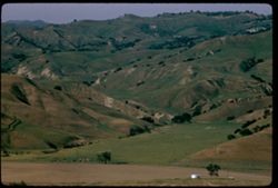
- Description:
- 100 f 8 TL
- Subject:
- Valleys, Trees, Meadows, Hills, and Peachtree Valley (Calif.)
- Series:
- 6-56
- Creator:
- Cushman, Charles W., 1896-1972
- Date Created:
- 1956-04-21
- Genre:
- Landscape photographs
- Frame Number:
- 4
- Street Address:
- California State Highway 198
- County:
- Monterey
- Abstract:
- Green meadow in Peach tree valley (from across deep (peach tree Valley) from 198 - 13 mi. east of San Lucas toward Mustang Ridge)
- Call Number:
- P08714
- Country:
- United States
- State/Province:
- California
- Alternate Identifier:
- 656.4
- Persistent URL:
- http://purl.dlib.indiana.edu/iudl/archives/cushman/P08714
- Holding Location:
- Bloomington - University Archives
Wells Library E460
1320 E 10th St.
Bloomington, IN 47405
Contact at archives@indiana.edu, 812-855-1127
-
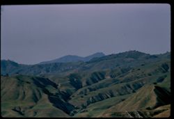
- Description:
- 100 f 8 TL
- Subject:
- Valleys, Mustang Ridge (Monterey County, Calif.), Mountains, Hills, Peachtree Valley (Calif.), and Canyons
- Series:
- 6-56
- Creator:
- Cushman, Charles W., 1896-1972
- Date Created:
- 1956-04-21
- Genre:
- Landscape photographs
- Frame Number:
- 3
- Street Address:
- California State Highway 198
- County:
- Monterey
- Abstract:
- View northward across deep (peach tree Valley) from 198 - 13 mi. east of San Lucas toward Mustang Ridge
- Call Number:
- P08713
- City:
- San Lucas
- Country:
- United States
- State/Province:
- California
- Alternate Identifier:
- 656.3
- Persistent URL:
- http://purl.dlib.indiana.edu/iudl/archives/cushman/P08713
- Holding Location:
- Bloomington - University Archives
Wells Library E460
1320 E 10th St.
Bloomington, IN 47405
Contact at archives@indiana.edu, 812-855-1127
-
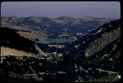
- Description:
- 100 f 8 TL
- Subject:
- Jolon Valley (Calif.), Roads, Jolon Grade, Trees, Mountains, and Hills
- Series:
- 6-56
- Creator:
- Cushman, Charles W., 1896-1972
- Date Created:
- 1956-04-21
- Genre:
- Landscape photographs
- Frame Number:
- 2
- County:
- Monterey
- Abstract:
- View eastward & down from Jolon grade
- Call Number:
- P08712
- Country:
- United States
- State/Province:
- California
- Alternate Identifier:
- 656.2
- Persistent URL:
- http://purl.dlib.indiana.edu/iudl/archives/cushman/P08712
- Holding Location:
- Bloomington - University Archives
Wells Library E460
1320 E 10th St.
Bloomington, IN 47405
Contact at archives@indiana.edu, 812-855-1127
-
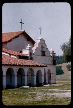
- Description:
- 100 f 4 TL
- Subject:
- Roofing tiles, Crosses, Trees, Roofs, Yards, Arcades (Architectural components), San Antonio de Pádua (Mission), Balconies, and Mission churches
- Series:
- 6-56
- Creator:
- Cushman, Charles W., 1896-1972
- Date Created:
- 1956-04-21
- Genre:
- Architectural photographs
- Frame Number:
- 1
- County:
- Monterey
- Abstract:
- Mission San Antonio de Padua
- Call Number:
- P08711
- Country:
- United States
- State/Province:
- California
- Alternate Identifier:
- 656.1
- Persistent URL:
- http://purl.dlib.indiana.edu/iudl/archives/cushman/P08711
- Holding Location:
- Bloomington - University Archives
Wells Library E460
1320 E 10th St.
Bloomington, IN 47405
Contact at archives@indiana.edu, 812-855-1127
-
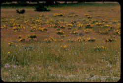
- Description:
- 100 f 6.3 TL
- Subject:
- Meadows, Flowers, Poppies, Grasses, and Owl's clovers
- Series:
- 5-56
- Creator:
- Cushman, Charles W., 1896-1972
- Date Created:
- 1956-04-21
- Genre:
- Identification photographs
- Frame Number:
- 37
- County:
- Monterey
- Abstract:
- Poppies, Owl clover & grass - near Jolon
- Call Number:
- P08710
- City:
- Jolon
- Country:
- United States
- State/Province:
- California
- Alternate Identifier:
- 556.37
- Persistent URL:
- http://purl.dlib.indiana.edu/iudl/archives/cushman/P08710
- Holding Location:
- Bloomington - University Archives
Wells Library E460
1320 E 10th St.
Bloomington, IN 47405
Contact at archives@indiana.edu, 812-855-1127
-
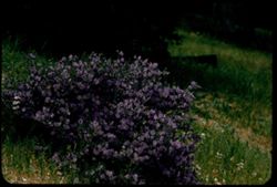
- Description:
- 100 f 8 TL
- Subject:
- Grasses, Flowers, Solanaceae, Hames Valley (Calif.), and Shrubs
- Series:
- 5-56
- Creator:
- Cushman, Charles W., 1896-1972
- Date Created:
- 1956-04-21
- Genre:
- Identification photographs
- Frame Number:
- 35
- County:
- Monterey
- Abstract:
- Lovely bush with blue flower - Hames Valley Solanum (nightshade)
- Call Number:
- P08708
- Country:
- United States
- State/Province:
- California
- Alternate Identifier:
- 556.35
- Persistent URL:
- http://purl.dlib.indiana.edu/iudl/archives/cushman/P08708
- Holding Location:
- Bloomington - University Archives
Wells Library E460
1320 E 10th St.
Bloomington, IN 47405
Contact at archives@indiana.edu, 812-855-1127
-
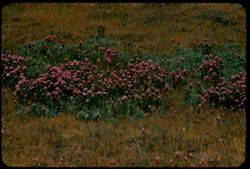
- Description:
- 100 f 7 TL
- Subject:
- Grasses, Flowers, Meadows, and Owl's clovers
- Series:
- 5-56
- Creator:
- Cushman, Charles W., 1896-1972
- Date Created:
- 1956-04-21
- Genre:
- Identification photographs
- Frame Number:
- 36
- County:
- Monterey
- Abstract:
- Owl's clover - near Jolon
- Call Number:
- P08709
- City:
- Jolon
- Country:
- United States
- State/Province:
- California
- Alternate Identifier:
- 556.36
- Persistent URL:
- http://purl.dlib.indiana.edu/iudl/archives/cushman/P08709
- Holding Location:
- Bloomington - University Archives
Wells Library E460
1320 E 10th St.
Bloomington, IN 47405
Contact at archives@indiana.edu, 812-855-1127
-
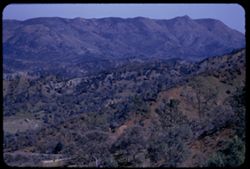
- Description:
- 100 f 5.6 tl
- Subject:
- Valleys, Hills, Diablo Range (Calif.), Roads, Mountains, Shrubs, and Trees
- Series:
- 7-55
- Creator:
- Cushman, Charles W., 1896-1972
- Date Created:
- 1955-03-20
- Genre:
- Landscape photographs
- Frame Number:
- 13
- Street Address:
- California State Highway 198 and Coalinga Road
- County:
- Monterey and Fresno
- Abstract:
- Eastward from summit of San Lucas Coalinga road 198 toward Diablo Range
- Call Number:
- P07737
- City:
- San Lucas
- Country:
- United States
- State/Province:
- California
- Alternate Identifier:
- 755.13
- Persistent URL:
- http://purl.dlib.indiana.edu/iudl/archives/cushman/P07737
- Holding Location:
- Bloomington - University Archives
Wells Library E460
1320 E 10th St.
Bloomington, IN 47405
Contact at archives@indiana.edu, 812-855-1127
-
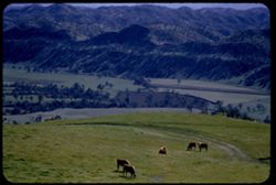
- Description:
- 100 f 5. tl
- Subject:
- Priest Valley (Calif.), Valleys, Grasses, Grazing, Trails & paths, Trees, Livestock, Cows, and Hills
- Series:
- 7-55
- Creator:
- Cushman, Charles W., 1896-1972
- Date Created:
- 1955-03-20
- Genre:
- Landscape photographs
- Frame Number:
- 11
- Street Address:
- California State Highway 198
- County:
- Fresno and Monterey
- Abstract:
- Southward from near Priest Valley near summit of Cal 198 between San Lucas & Coalinga
- Call Number:
- P07735
- City:
- Coalinga and San Lucas
- Country:
- United States
- State/Province:
- California
- Alternate Identifier:
- 755.11
- Persistent URL:
- http://purl.dlib.indiana.edu/iudl/archives/cushman/P07735
- Holding Location:
- Bloomington - University Archives
Wells Library E460
1320 E 10th St.
Bloomington, IN 47405
Contact at archives@indiana.edu, 812-855-1127
-

- Description:
- 100 f 5. tl
- Subject:
- Logs, Cows, Livestock, Priest Valley (Calif.), Trails & paths, Trees, Grazing, and Valleys
- Series:
- 7-55
- Creator:
- Cushman, Charles W., 1896-1972
- Date Created:
- 1955-03-20
- Genre:
- Landscape photographs
- Frame Number:
- 10
- Street Address:
- California State Highway 198
- County:
- Monterey and Fresno
- Abstract:
- Southward from near Priest Valley near summit of Cal 198 between San Lucas & Coalinga
- Call Number:
- P07734
- City:
- Coalinga and San Lucas
- Country:
- United States
- State/Province:
- California
- Alternate Identifier:
- 755.10
- Persistent URL:
- http://purl.dlib.indiana.edu/iudl/archives/cushman/P07734
- Holding Location:
- Bloomington - University Archives
Wells Library E460
1320 E 10th St.
Bloomington, IN 47405
Contact at archives@indiana.edu, 812-855-1127
-
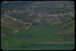
- Description:
- 100 f 6.3 tl
- Subject:
- San Lorenzo Creek (Calif.), Valleys, Grasses, Roads, Trees, Peach trees, Croplands, Hills, and Peachtree Valley (Calif.)
- Series:
- 7-55
- Creator:
- Cushman, Charles W., 1896-1972
- Date Created:
- 1955-03-20
- Genre:
- Landscape photographs
- Frame Number:
- 9
- Street Address:
- California State Highway 198
- County:
- Monterey
- Abstract:
- Lovely Valley of San Lorenzo Creek (and views across it Peachtree Valley) from top of Cal 198 12 or 13 mi. east of San Louas. (no. 9 was turned up and back)
- Call Number:
- P07733
- City:
- San Lucas
- Country:
- United States
- State/Province:
- California
- Alternate Identifier:
- 755.9
- Persistent URL:
- http://purl.dlib.indiana.edu/iudl/archives/cushman/P07733
- Holding Location:
- Bloomington - University Archives
Wells Library E460
1320 E 10th St.
Bloomington, IN 47405
Contact at archives@indiana.edu, 812-855-1127
-
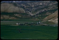
- Description:
- 100 f 6.3 tl
- Subject:
- Valleys, Roads, San Lorenzo Creek (Calif.), Mountains, Agricultural facilities, Trees, Vehicles, Storage tanks, Dwellings, and Utility poles
- Series:
- 7-55
- Creator:
- Cushman, Charles W., 1896-1972
- Date Created:
- 1955-03-20
- Genre:
- Landscape photographs
- Frame Number:
- 7
- Street Address:
- California State Highway 198
- County:
- Monterey
- Abstract:
- Lovely Valley of San Lorenzo Creek (and views across it Peachtree Valley) from top of Cal 198 12 or 13 mi. east of San Louas. (no. 9 was turned up and back)
- Call Number:
- P07731
- City:
- San Lucas
- Country:
- United States
- State/Province:
- California
- Alternate Identifier:
- 755.7
- Persistent URL:
- http://purl.dlib.indiana.edu/iudl/archives/cushman/P07731
- Holding Location:
- Bloomington - University Archives
Wells Library E460
1320 E 10th St.
Bloomington, IN 47405
Contact at archives@indiana.edu, 812-855-1127
-
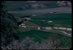
- Description:
- 100 f 6.3 tl
- Subject:
- San Lorenzo Creek (Calif.), Valleys, Grasses, Roads, Trees, Peach trees, Fences, Dwellings, Utility poles, and Streams
- Series:
- 7-55
- Creator:
- Cushman, Charles W., 1896-1972
- Date Created:
- 1955-03-20
- Genre:
- Landscape photographs
- Frame Number:
- 8
- Street Address:
- California State Highway 198
- County:
- Monterey
- Abstract:
- Lovely Valley of San Lorenzo Creek (and views across it Peachtree Valley) from top of Cal 198 12 or 13 mi. east of San Louas. (no. 9 was turned up and back)
- Call Number:
- P07732
- City:
- San Lucas
- Country:
- United States
- State/Province:
- California
- Alternate Identifier:
- 755.8
- Persistent URL:
- http://purl.dlib.indiana.edu/iudl/archives/cushman/P07732
- Holding Location:
- Bloomington - University Archives
Wells Library E460
1320 E 10th St.
Bloomington, IN 47405
Contact at archives@indiana.edu, 812-855-1127
-
Little valley of San Lorenzo creek from Cal Hwy 198 a dozen miles east of San Lucas, Monterey County
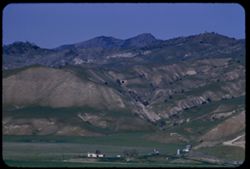
- Description:
- 100 f 6.3 tl
- Subject:
- San Lorenzo Creek (Calif.), Valleys, Roads, Trees, Mountains, Buildings, Dwellings, Agricultural facilities, and Storage tanks
- Series:
- 7-55
- Creator:
- Cushman, Charles W., 1896-1972
- Date Created:
- 1955-03-20
- Genre:
- Landscape photographs
- Frame Number:
- 6
- Street Address:
- California State Highway 198
- County:
- Monterey
- Abstract:
- Lovely Valley of San Lorenzo Creek (and views across it Peachtree Valley) from top of Cal 198 12 or 13 mi. east of San Louas. (no. 9 was turned up and back)
- Call Number:
- P07730
- City:
- San Lucas
- Country:
- United States
- State/Province:
- California
- Alternate Identifier:
- 755.6
- Persistent URL:
- http://purl.dlib.indiana.edu/iudl/archives/cushman/P07730
- Holding Location:
- Bloomington - University Archives
Wells Library E460
1320 E 10th St.
Bloomington, IN 47405
Contact at archives@indiana.edu, 812-855-1127
-
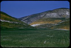
- Description:
- 100 f 6.3 tl
- Subject:
- Valleys, Grasses, and Hills
- Series:
- 7-55
- Creator:
- Cushman, Charles W., 1896-1972
- Date Created:
- 1955-03-20
- Genre:
- Landscape photographs
- Frame Number:
- 5
- Street Address:
- California State Highway 198
- County:
- Monterey
- Abstract:
- Round hills north of Cal. 198 about 10 mi. east of San Lucas
- Call Number:
- P07729
- City:
- San Lucas
- Country:
- United States
- State/Province:
- California
- Alternate Identifier:
- 755.5
- Persistent URL:
- http://purl.dlib.indiana.edu/iudl/archives/cushman/P07729
- Holding Location:
- Bloomington - University Archives
Wells Library E460
1320 E 10th St.
Bloomington, IN 47405
Contact at archives@indiana.edu, 812-855-1127
-
![Mountains of Gabilau Range on east side of Salinas Valley from US 101 [zuni] south of Greenfield, Monterey County](https://iiif.uits.iu.edu/iiif/2/f4752h29j%2Ffiles%2F3fdde8f0-e7ec-432e-891b-88663a382edf/full/250,/0/default.jpg)
- Description:
- 100 f 6.3 tl
- Subject:
- Valleys, Hills, Salinas Valley (Calif.), Gabilan Range (Calif.), Mountains, Dwellings, Trees, Plants, Farms, and Agricultural facilities
- Series:
- 7-55
- Creator:
- Cushman, Charles W., 1896-1972
- Date Created:
- 1955-03-20
- Genre:
- Landscape photographs
- Frame Number:
- 3
- Street Address:
- United States Highway 101
- County:
- Monterey
- Abstract:
- Mtns part of Gabilau range on east side of Salinas Valley from zuni south of Greenfield on US 101
- Call Number:
- P07727
- City:
- Greenfield
- Country:
- United States
- State/Province:
- California
- Alternate Identifier:
- 755.3
- Persistent URL:
- http://purl.dlib.indiana.edu/iudl/archives/cushman/P07727
- Holding Location:
- Bloomington - University Archives
Wells Library E460
1320 E 10th St.
Bloomington, IN 47405
Contact at archives@indiana.edu, 812-855-1127
-
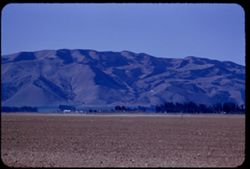
- Description:
- 100 f 5.6 tl
- Subject:
- Valleys, Santa Lucia Range (Calif.), Roads, Salinas Valley (Calif.), Trees, Mountains, Fences, and Dwellings
- Series:
- 7-55
- Creator:
- Cushman, Charles W., 1896-1972
- Date Created:
- 1955-03-20
- Genre:
- Landscape photographs
- Frame Number:
- 4
- Street Address:
- United States Highway 101
- County:
- Monterey
- Abstract:
- Folded mtns on west side of Salinas Valley Sierra de Salinas from zuni south of Greenfield on US 101
- Call Number:
- P07728
- City:
- Greenfield
- Country:
- United States
- State/Province:
- California
- Alternate Identifier:
- 755.4
- Persistent URL:
- http://purl.dlib.indiana.edu/iudl/archives/cushman/P07728
- Holding Location:
- Bloomington - University Archives
Wells Library E460
1320 E 10th St.
Bloomington, IN 47405
Contact at archives@indiana.edu, 812-855-1127
-
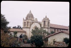
- Description:
- 25 f 4.5
- Subject:
- Towers, Bell towers, Missions, Trees, Flowers, Roofs, Mission San Carlos Borromeo (Carmel, Calif.), Shrubs, Domes, Mission churches, and Crosses
- Series:
- 9-52
- Creator:
- Cushman, Charles W., 1896-1972
- Date Created:
- 1952-03-04
- Genre:
- Architectural photographs
- Frame Number:
- 36
- County:
- Monterey
- Abstract:
- San Carlos Borromeo Mission at Carmel [L]
- Call Number:
- P05833
- City:
- Carmel
- Country:
- United States
- State/Province:
- California
- Alternate Identifier:
- 952.36
- Persistent URL:
- http://purl.dlib.indiana.edu/iudl/archives/cushman/P05833
- Holding Location:
- Bloomington - University Archives
Wells Library E460
1320 E 10th St.
Bloomington, IN 47405
Contact at archives@indiana.edu, 812-855-1127
-
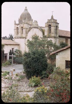
- Description:
- 25 f 4
- Subject:
- Towers, Crosses, Missions, Trees, Flowers, Walkways, Mission San Carlos Borromeo (Carmel, Calif.), Shrubs, Windows, Domes, Bell towers, Courtyards, and Missi...
- Series:
- 9-52
- Creator:
- Cushman, Charles W., 1896-1972
- Date Created:
- 1952-03-04
- Genre:
- Architectural photographs
- Frame Number:
- 35
- County:
- Monterey
- Abstract:
- San Carlos Borromeo Mission at Carmel
- Call Number:
- P05832
- City:
- Carmel
- Country:
- United States
- State/Province:
- California
- Alternate Identifier:
- 952.35
- Persistent URL:
- http://purl.dlib.indiana.edu/iudl/archives/cushman/P05832
- Holding Location:
- Bloomington - University Archives
Wells Library E460
1320 E 10th St.
Bloomington, IN 47405
Contact at archives@indiana.edu, 812-855-1127
-
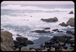
- Description:
- 50 f 3.5
- Subject:
- Point Joe (Calif.), Pacific Ocean, Pacific Coast (Calif.), Rocks, Beaches, Seas, Oceans, and Monterey Peninsula (Calif.)
- Series:
- 9-52
- Creator:
- Cushman, Charles W., 1896-1972
- Date Created:
- 1952-03-03
- Genre:
- Seascapes
- Frame Number:
- 34
- Street Address:
- Seventeen-Mile Drive
- County:
- Monterey
- Abstract:
- Pt. Joe-meeting of the Ocean currents
- Call Number:
- P05831
- Country:
- United States
- State/Province:
- California
- Alternate Identifier:
- 952.34
- Persistent URL:
- http://purl.dlib.indiana.edu/iudl/archives/cushman/P05831
- Holding Location:
- Bloomington - University Archives
Wells Library E460
1320 E 10th St.
Bloomington, IN 47405
Contact at archives@indiana.edu, 812-855-1127