
Search Constraints
You searched for:
Campus
IUB
Remove constraint Campus: IUB
Creator
Cushman, Charles W., 1896-1972
Remove constraint Creator: Cushman, Charles W., 1896-1972
Pages
0-99 pages
Remove constraint Pages: 0-99 pages
Series
11-58
Remove constraint Series: 11-58
Subject
Clouds
Remove constraint Subject: Clouds
« Previous |
1 - 20 of 30
|
Next »
Search Results
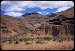
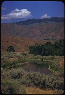
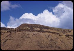
-
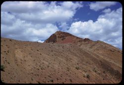
- Description:
- 100 f 6.3 SL
- Subject:
- Mountains, Shrubs, Rock formations, Malheur River (Or.), and Clouds
- Series:
- 11-58
- Creator:
- Cushman, Charles W., 1896-1972
- Date Created:
- 1958-06-14
- Genre:
- Landscape photographs
- Frame Number:
- 11
- County:
- Malheur
- Abstract:
- Tip of nearby
- Call Number:
- P09986
- Country:
- United States
- State/Province:
- Oregon
- Alternate Identifier:
- 1158.11
- Persistent URL:
- http://purl.dlib.indiana.edu/iudl/archives/cushman/P09986
- Holding Location:
- Bloomington - University Archives
Wells Library E460
1320 E 10th St.
Bloomington, IN 47405
Contact at archives@indiana.edu, 812-855-1127
-
- Description:
- 100 f 8 TL HF
- Subject:
- Hills, Mountains, Trees, Clouds, and Fences
- Series:
- 11-58
- Creator:
- Cushman, Charles W., 1896-1972
- Date Created:
- 1958-06-15
- Genre:
- Landscape photographs and Views
- Frame Number:
- 37
- County:
- Boise
- Abstract:
- Horseshoe Bend from south
- Call Number:
- P10012
- City:
- Horseshoe Bend
- Country:
- United States
- State/Province:
- Idaho
- Alternate Identifier:
- 1158.37
- Persistent URL:
- http://purl.dlib.indiana.edu/iudl/archives/cushman/P10012
- Holding Location:
- Bloomington - University Archives
Wells Library E460
1320 E 10th St.
Bloomington, IN 47405
Contact at archives@indiana.edu, 812-855-1127
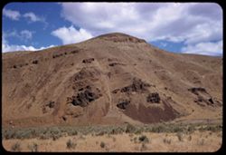
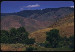
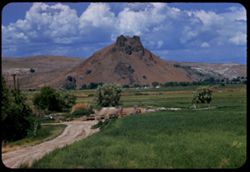
-
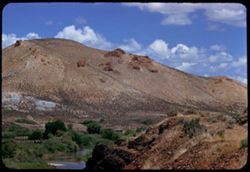
- Description:
- 100 f 8 TL
- Subject:
- Rocks, Shrubs, Clouds, Hills, Malheur River (Or.), Rivers, and Rock formations
- Series:
- 11-58
- Creator:
- Cushman, Charles W., 1896-1972
- Date Created:
- 1958-06-14
- Genre:
- Landscape photographs
- Frame Number:
- 15
- County:
- Malheur and Harney
- Abstract:
- [Nobs]
- Call Number:
- P09990
- City:
- Burns
- Country:
- United States
- State/Province:
- Oregon
- Alternate Identifier:
- 1158.15
- Persistent URL:
- http://purl.dlib.indiana.edu/iudl/archives/cushman/P09990
- Holding Location:
- Bloomington - University Archives
Wells Library E460
1320 E 10th St.
Bloomington, IN 47405
Contact at archives@indiana.edu, 812-855-1127
-
- Description:
- 100 f 6.3 SL
- Subject:
- Rocks, Shrubs, Clouds, and Hills
- Series:
- 11-58
- Creator:
- Cushman, Charles W., 1896-1972
- Date Created:
- 1958-06-14
- Genre:
- Landscape photographs
- Frame Number:
- 7
- Street Address:
- United States Highway 20
- County:
- Malheur
- Abstract:
- On south sid
- Call Number:
- P09982
- Country:
- United States
- State/Province:
- Oregon
- Alternate Identifier:
- 1158.7
- Persistent URL:
- http://purl.dlib.indiana.edu/iudl/archives/cushman/P09982
- Holding Location:
- Bloomington - University Archives
Wells Library E460
1320 E 10th St.
Bloomington, IN 47405
Contact at archives@indiana.edu, 812-855-1127
-
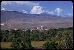
- Description:
- 100 f 5.6 TL
- Subject:
- Houses, Trees, Mountains, Buildings, Clouds, and Capitols
- Series:
- 11-58
- Creator:
- Cushman, Charles W., 1896-1972
- Date Created:
- 1958-06-14
- Genre:
- Landscape photographs
- Frame Number:
- 22
- County:
- Boise
- Abstract:
- Boise from western heights
- Call Number:
- P09997
- City:
- Boise
- Country:
- United States
- State/Province:
- Idaho
- Alternate Identifier:
- 1158.22
- Persistent URL:
- http://purl.dlib.indiana.edu/iudl/archives/cushman/P09997
- Holding Location:
- Bloomington - University Archives
Wells Library E460
1320 E 10th St.
Bloomington, IN 47405
Contact at archives@indiana.edu, 812-855-1127
-
- Description:
- 100 f 6.3 TL HF
- Subject:
- Boise Ridge (Idaho), Grasses, Trees, Boulders, Meadows, Mountains, Clouds, Hills, and Rivers
- Series:
- 11-58
- Creator:
- Cushman, Charles W., 1896-1972
- Date Created:
- 1958-06-15
- Genre:
- Landscape photographs
- Frame Number:
- 27
- County:
- Boise
- Abstract:
- Ridge above Horeshoe Bend
- Call Number:
- P10002
- City:
- Horseshoe Bend
- Country:
- United States
- State/Province:
- Idaho
- Alternate Identifier:
- 1158.27
- Persistent URL:
- http://purl.dlib.indiana.edu/iudl/archives/cushman/P10002
- Holding Location:
- Bloomington - University Archives
Wells Library E460
1320 E 10th St.
Bloomington, IN 47405
Contact at archives@indiana.edu, 812-855-1127
-
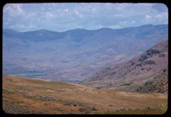
- Description:
- 100 f 5.6 TL HF
- Subject:
- Boise Ridge (Idaho), Valleys, Mountains, Shrubs, and Clouds
- Series:
- 11-58
- Creator:
- Cushman, Charles W., 1896-1972
- Date Created:
- 1958-06-15
- Genre:
- Landscape photographs
- Frame Number:
- 24
- County:
- Boise
- Abstract:
- Boise Ridge
- Call Number:
- P09999
- Country:
- United States
- State/Province:
- Idaho
- Alternate Identifier:
- 1158.24
- Persistent URL:
- http://purl.dlib.indiana.edu/iudl/archives/cushman/P09999
- Holding Location:
- Bloomington - University Archives
Wells Library E460
1320 E 10th St.
Bloomington, IN 47405
Contact at archives@indiana.edu, 812-855-1127
-
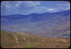
- Description:
- 100 f 5.6 TL HF
- Subject:
- Boise Ridge (Idaho), Grasses, Mountains, Fences, Shrubs, Clouds, and Hills
- Series:
- 11-58
- Creator:
- Cushman, Charles W., 1896-1972
- Date Created:
- 1958-06-15
- Genre:
- Landscape photographs
- Frame Number:
- 26
- County:
- Boise
- Abstract:
- Slope of Boise ridge - hazy
- Call Number:
- P10001
- City:
- Horseshoe Bend
- Country:
- United States
- State/Province:
- Idaho
- Alternate Identifier:
- 1158.26
- Persistent URL:
- http://purl.dlib.indiana.edu/iudl/archives/cushman/P10001
- Holding Location:
- Bloomington - University Archives
Wells Library E460
1320 E 10th St.
Bloomington, IN 47405
Contact at archives@indiana.edu, 812-855-1127
-
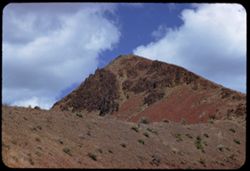
- Description:
- 100 f 6.3 SL
- Subject:
- Grasses, Volcanic rock, Mountains, Shrubs, and Clouds
- Series:
- 11-58
- Creator:
- Cushman, Charles W., 1896-1972
- Date Created:
- 1958-06-14
- Genre:
- Landscape photographs
- Frame Number:
- 5
- Street Address:
- United States Highway 20
- County:
- Malheur
- Abstract:
- Great brown lava
- Call Number:
- P09980
- Country:
- United States
- State/Province:
- Oregon
- Alternate Identifier:
- 1158.5
- Persistent URL:
- http://purl.dlib.indiana.edu/iudl/archives/cushman/P09980
- Holding Location:
- Bloomington - University Archives
Wells Library E460
1320 E 10th St.
Bloomington, IN 47405
Contact at archives@indiana.edu, 812-855-1127
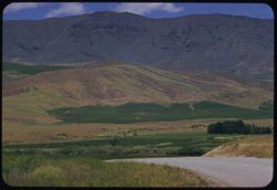
-
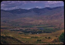
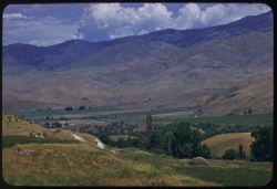
- Description:
- 100 f 6.3 TL
- Subject:
- Farms, Trees, Meadows, Buildings, Clouds, and Hills
- Series:
- 11-58
- Creator:
- Cushman, Charles W., 1896-1972
- Date Created:
- 1958-06-15
- Genre:
- Landscape photographs
- Frame Number:
- 23
- County:
- Boise
- Abstract:
- Farm scene 15 mi. north of Boise
- Call Number:
- P09998
- City:
- Boise
- Country:
- United States
- State/Province:
- Idaho
- Alternate Identifier:
- 1158.23
- Persistent URL:
- http://purl.dlib.indiana.edu/iudl/archives/cushman/P09998
- Holding Location:
- Bloomington - University Archives
Wells Library E460
1320 E 10th St.
Bloomington, IN 47405
Contact at archives@indiana.edu, 812-855-1127
-
- Description:
- 100 f 6.3 SL
- Subject:
- Grasses, Volcanic rock, Shrubs, Clouds, and Hills
- Series:
- 11-58
- Creator:
- Cushman, Charles W., 1896-1972
- Date Created:
- 1958-06-14
- Genre:
- Landscape photographs
- Frame Number:
- 6
- Street Address:
- United States Highway 20
- County:
- Malheur
- Abstract:
- Great brown lava
- Call Number:
- P09981
- Country:
- United States
- State/Province:
- Oregon
- Alternate Identifier:
- 1158.6
- Persistent URL:
- http://purl.dlib.indiana.edu/iudl/archives/cushman/P09981
- Holding Location:
- Bloomington - University Archives
Wells Library E460
1320 E 10th St.
Bloomington, IN 47405
Contact at archives@indiana.edu, 812-855-1127
-
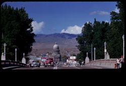
- Description:
- 100 f 6.3 TL
- Subject:
- Dogs, Automobiles, Trees, Signs (Notices), Streets, Capitols, Clouds, Pediments, Domes, People, Street lights, and Hills
- Series:
- 11-58
- Creator:
- Cushman, Charles W., 1896-1972
- Date Created:
- 1958-06-14
- Genre:
- Cityscape photographs
- Frame Number:
- 19
- Street Address:
- Capitol Avenue
- County:
- Boise
- Abstract:
- State Capitol
- Call Number:
- P09994
- City:
- Boise
- Country:
- United States
- State/Province:
- Idaho
- Physical Description:
- masked.
- Alternate Identifier:
- 1158.19
- Persistent URL:
- http://purl.dlib.indiana.edu/iudl/archives/cushman/P09994
- Holding Location:
- Bloomington - University Archives
Wells Library E460
1320 E 10th St.
Bloomington, IN 47405
Contact at archives@indiana.edu, 812-855-1127
-
- Description:
- 100 f 8 TL HF
- Subject:
- Rocks, Trees, Payette River (Idaho), Mountains, Shrubs, Clouds, Hills, and Rivers
- Series:
- 11-58
- Creator:
- Cushman, Charles W., 1896-1972
- Date Created:
- 1958-06-15
- Genre:
- Landscape photographs
- Frame Number:
- 35
- County:
- Boise
- Abstract:
- Mountains above Payette river near Horseshoe Bend [P]
- Call Number:
- P10010
- City:
- Horseshoe Bend
- Country:
- United States
- State/Province:
- Idaho
- Alternate Identifier:
- 1158.35
- Persistent URL:
- http://purl.dlib.indiana.edu/iudl/archives/cushman/P10010
- Holding Location:
- Bloomington - University Archives
Wells Library E460
1320 E 10th St.
Bloomington, IN 47405
Contact at archives@indiana.edu, 812-855-1127
-
- Description:
- 100 f 6.3 TL HF
- Subject:
- Grasses, Roads, Trees, Buttes, Squaw Butte (Gem County, Idaho), Clouds, and Hills
- Series:
- 11-58
- Creator:
- Cushman, Charles W., 1896-1972
- Date Created:
- 1958-06-15
- Genre:
- Landscape photographs
- Frame Number:
- 32
- County:
- Gem
- Abstract:
- Squaw Butte and green foothills
- Call Number:
- P10007
- Country:
- United States
- State/Province:
- Idaho
- Alternate Identifier:
- 1158.32
- Persistent URL:
- http://purl.dlib.indiana.edu/iudl/archives/cushman/P10007
- Holding Location:
- Bloomington - University Archives
Wells Library E460
1320 E 10th St.
Bloomington, IN 47405
Contact at archives@indiana.edu, 812-855-1127
-
- Description:
- 100 f 8 TL HF
- Subject:
- Trees, Payette River (Idaho), Mountains, Shrubs, Clouds, Hills, and Rivers
- Series:
- 11-58
- Creator:
- Cushman, Charles W., 1896-1972
- Date Created:
- 1958-06-15
- Genre:
- Landscape photographs
- Frame Number:
- 36
- County:
- Boise
- Abstract:
- Similar
- Call Number:
- P10011
- City:
- Horseshoe Bend
- Country:
- United States
- State/Province:
- Idaho
- Alternate Identifier:
- 1158.36
- Persistent URL:
- http://purl.dlib.indiana.edu/iudl/archives/cushman/P10011
- Holding Location:
- Bloomington - University Archives
Wells Library E460
1320 E 10th St.
Bloomington, IN 47405
Contact at archives@indiana.edu, 812-855-1127
-
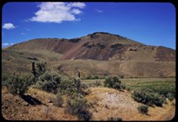
- Description:
- 100 f 6.3 TL
- Subject:
- Rock formations, Mountains, Plants, Malheur River (Or.), Volcanic rock, and Clouds
- Series:
- 11-58
- Creator:
- Cushman, Charles W., 1896-1972
- Date Created:
- 1958-06-14
- Genre:
- Landscape photographs
- Frame Number:
- 13
- County:
- Malheur
- Abstract:
- Tip of nearby
- Call Number:
- P09988
- Country:
- United States
- State/Province:
- Oregon
- Alternate Identifier:
- 1158.13
- Persistent URL:
- http://purl.dlib.indiana.edu/iudl/archives/cushman/P09988
- Holding Location:
- Bloomington - University Archives
Wells Library E460
1320 E 10th St.
Bloomington, IN 47405
Contact at archives@indiana.edu, 812-855-1127
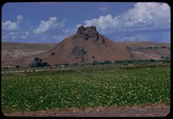
-
- Description:
- 100 f 7 TL
- Subject:
- Volcanic rock, Buttes, Clouds, and Malheur River (Or.)
- Series:
- 11-58
- Creator:
- Cushman, Charles W., 1896-1972
- Date Created:
- 1958-06-14
- Genre:
- Landscape photographs
- Frame Number:
- 3
- Street Address:
- United States Highway 20
- County:
- Malheur
- Abstract:
- Lava butte
- Call Number:
- P09978
- Country:
- United States
- State/Province:
- Oregon
- Alternate Identifier:
- 1158.3
- Persistent URL:
- http://purl.dlib.indiana.edu/iudl/archives/cushman/P09978
- Holding Location:
- Bloomington - University Archives
Wells Library E460
1320 E 10th St.
Bloomington, IN 47405
Contact at archives@indiana.edu, 812-855-1127
-
- Description:
- 100 f 8 TL
- Subject:
- Hills, Trees, Plants, Farms, and Clouds
- Series:
- 11-58
- Creator:
- Cushman, Charles W., 1896-1972
- Date Created:
- 1958-06-14
- Genre:
- Landscape photographs
- Frame Number:
- 16
- County:
- Malheur
- Abstract:
- Ridge above Vale
- Call Number:
- P09991
- City:
- Vale
- Country:
- United States
- State/Province:
- Oregon
- Alternate Identifier:
- 1158.16
- Persistent URL:
- http://purl.dlib.indiana.edu/iudl/archives/cushman/P09991
- Holding Location:
- Bloomington - University Archives
Wells Library E460
1320 E 10th St.
Bloomington, IN 47405
Contact at archives@indiana.edu, 812-855-1127
-
- Description:
- 100 f 7 TL
- Subject:
- Mountains, Dirt roads, Trees, Plants, Rock formations, and Clouds
- Series:
- 11-58
- Creator:
- Cushman, Charles W., 1896-1972
- Date Created:
- 1958-06-14
- Genre:
- Landscape photographs
- Frame Number:
- 17
- Street Address:
- United States Highway 20
- County:
- Malheur
- Abstract:
- Rock like a pussy cat - east of Vale
- Call Number:
- P09992
- City:
- Vale
- Country:
- United States
- State/Province:
- Oregon
- Alternate Identifier:
- 1158.17
- Persistent URL:
- http://purl.dlib.indiana.edu/iudl/archives/cushman/P09992
- Holding Location:
- Bloomington - University Archives
Wells Library E460
1320 E 10th St.
Bloomington, IN 47405
Contact at archives@indiana.edu, 812-855-1127
-
- Description:
- 100 f 8 TL
- Subject:
- Agriculture, Mountains, Trees, Plants, Rock formations, Hills, and Clouds
- Series:
- 11-58
- Creator:
- Cushman, Charles W., 1896-1972
- Date Created:
- 1958-06-14
- Genre:
- Landscape photographs
- Frame Number:
- 18
- Street Address:
- United States Highway 20
- County:
- Malheur
- Abstract:
- Rock like a pussy cat - east of Vale
- Call Number:
- P09993
- City:
- Vale
- Country:
- United States
- State/Province:
- Oregon
- Alternate Identifier:
- 1158.18
- Persistent URL:
- http://purl.dlib.indiana.edu/iudl/archives/cushman/P09993
- Holding Location:
- Bloomington - University Archives
Wells Library E460
1320 E 10th St.
Bloomington, IN 47405
Contact at archives@indiana.edu, 812-855-1127