
Search Constraints
You searched for:
Campus
IUB
Remove constraint Campus: IUB
Creator
Hollingsworth, John M.
Remove constraint Creator: Hollingsworth, John M.
Holding Location
B-WELLS
Remove constraint Holding Location: B-WELLS
Pages
0-99 pages
Remove constraint Pages: 0-99 pages
« Previous |
1 - 10 of 68
|
Next »
Search Results
-
- Subject:
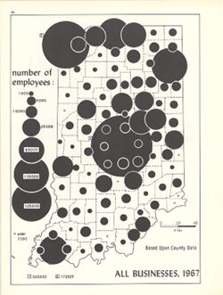
- Topical Subject: Labor supply, Topical Subject: Business enterprises--Employees, and Geographic Subject: Indiana
- Creator:
- Hollingsworth, John M. and Kingsbury, Robert C.
- Publisher:
- Indiana University. Department of Geography
- Date Created:
- 1970
- Identifier:
- VAC3073-M-00226
- Genre:
- Thematic maps
- Geographic Location:
- Coordinates: W0880700 W0844500 N0414500 N0374600
- Related URL:
- Catalog URL: https://iucat.iu.edu/catalog/15948581
- Abstract:
- Graduated symbol map. Shows number of employees by county. Detached from: An atlas of Indiana / by Robert C. Kingsbury , with contributions from John M. H...
- Call Number:
- G4091.G8 1967 .K56
- Caption:
- Imprint: Bloomington, Indiana : Department of Geography, Indiana University, [1970]
- Physical Description:
- Dimensions: 26 x 18 cm, on sheet 28 x 21 cm and Scale: Approximately 1:1,950,000
- Alternate Identifier:
- Alternate ID: 317383IP and Title Control Number: a15948581
- Persistent URL:
- https://purl.dlib.indiana.edu/iudl/images/VAC3073/VAC3073-M-00226
- Provenance:
- An atlas of Indiana / by Robert C. Kingsbury [1970].
-
- Subject:
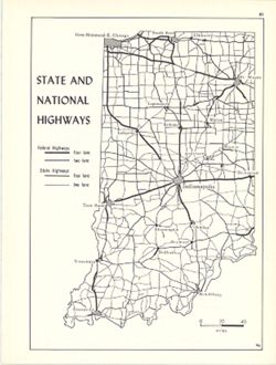
- Geographic Subject: Indiana and Topical Subject: Roads
- Creator:
- Hollingsworth, John M. and Kingsbury, Robert C.
- Publisher:
- Indiana University. Department of Geography
- Date Created:
- 1970
- Identifier:
- VAC3073-M-00815
- Genre:
- Road maps
- Geographic Location:
- Coordinates: W0880700 W0844500 N0414500 N0374600
- Related URL:
- Catalog URL: https://iucat.iu.edu/catalog/15938064
- Abstract:
- Shows two lane and four lane federal highways and two lane and four lane state highways. Detached from: An atlas of Indiana / by Robert C. Kingsbury , wit...
- Call Number:
- G4091.P2 1970 .K56
- Caption:
- Imprint: Bloomington, Indiana : Department of Geography, Indiana University, [1970]
- Physical Description:
- Scale: Approximately 1:2,000,000 and Dimensions: 26 x 18 cm, on sheet 28 x 21 cm
- Alternate Identifier:
- Alternate ID: 317383IP and Title Control Number: a15938064
- Persistent URL:
- https://purl.dlib.indiana.edu/iudl/images/VAC3073/VAC3073-M-00815
- Provenance:
- An atlas of Indiana / by Robert C. Kingsbury [1970].
-
- Subject:
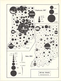
- Topical Subject: Retail trade--Employees, Geographic Subject: Indiana, and Topical Subject: Labor supply
- Creator:
- Hollingsworth, John M. and Kingsbury, Robert C.
- Publisher:
- Indiana University. Department of Geography
- Date Created:
- 1970
- Identifier:
- VAC3073-M-00179
- Genre:
- Thematic maps
- Geographic Location:
- Coordinates: W0880700 W0844500 N0414500 N0374600
- Related URL:
- Catalog URL: https://iucat.iu.edu/catalog/15987122
- Abstract:
- 2 maps on 1 sheet, Retail trade employees, 1967, and Retail trade sales, 1963. Graduated symbol map. Detached from: An atlas of Indiana / by Robert C. Kin...
- Call Number:
- G4091.G8 1963 .K57
- Caption:
- Imprint: Bloomington, Indiana : Department of Geography, Indiana University, [1970]
- Physical Description:
- Dimensions: on sheet 28 x 21 cm and Scale: Approximately 1:2,700,000
- Alternate Identifier:
- Alternate ID: 317383IP and Title Control Number: a15987122
- Persistent URL:
- https://purl.dlib.indiana.edu/iudl/images/VAC3073/VAC3073-M-00179
- Provenance:
- An atlas of Indiana / by Robert C. Kingsbury [1970].
-
- Subject:
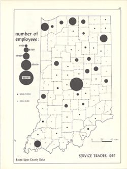
- Topical Subject: Service industries workers, Geographic Subject: Indiana, and Topical Subject: Labor supply
- Creator:
- Hollingsworth, John M. and Kingsbury, Robert C.
- Publisher:
- Indiana University. Department of Geography
- Date Created:
- 1970
- Identifier:
- VAC3073-M-00224
- Genre:
- Thematic maps
- Geographic Location:
- Coordinates: W0880700 W0844500 N0414500 N0374600
- Related URL:
- Catalog URL: https://iucat.iu.edu/catalog/15950444
- Abstract:
- Graduated symbol map. Shows number of employees by county. Detached from: An atlas of Indiana / by Robert C. Kingsbury , with contributions from John M. H...
- Call Number:
- G4091.G8 1967 .K57
- Caption:
- Imprint: Bloomington, Indiana : Department of Geography, Indiana University, [1970]
- Physical Description:
- Dimensions: 26 x 18 cm, on sheet 28 x 21 cm and Scale: Approximately 1:1,950,000
- Alternate Identifier:
- Alternate ID: 317383IP and Title Control Number: a15950444
- Persistent URL:
- https://purl.dlib.indiana.edu/iudl/images/VAC3073/VAC3073-M-00224
- Provenance:
- An atlas of Indiana / by Robert C. Kingsbury [1970].
-
- Subject:
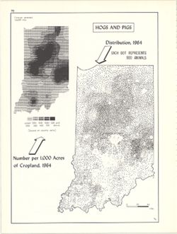
- Geographic Subject: Indiana, Topical Subject: Swine--Geographical distribution, and Topical Subject: SYMAP (Computer program language)
- Creator:
- Hollingsworth, John M., Kingsbury, Robert C., and Indiana University. Research Computing Center
- Publisher:
- Indiana University. Department of Geography
- Date Created:
- 1970
- Identifier:
- VAC3073-M-00632
- Genre:
- Thematic maps
- Geographic Location:
- Coordinates: W0880700 W0844500 N0414500 N0374600
- Related URL:
- Catalog URL: https://iucat.iu.edu/catalog/15984668
- Abstract:
- Dot distribution map. Includes ancillary computer generated isopleth map Hogs and pigs: number per 1,000 acres of cropland, 1964. ASCII-art map created using...
- Call Number:
- G4091.J5 1964 .K57
- Caption:
- Imprint: Bloomington, Indiana : Department of Geography, Indiana University, [1970]
- Physical Description:
- Dimensions: 26 x 18 cm, on sheet 28 x 21 cm and Scale: Approximately 1:2,534,400
- Alternate Identifier:
- Title Control Number: a15984668 and Alternate ID: 317383IP
- Persistent URL:
- https://purl.dlib.indiana.edu/iudl/images/VAC3073/VAC3073-M-00632
- Provenance:
- An atlas of Indiana / by Robert C. Kingsbury [1970].
-
- Subject:
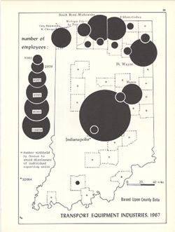
- Topical Subject: Labor supply, Topical Subject: Transportation equipment industry--Employees, and Geographic Subject: Indiana
- Creator:
- Kingsbury, Robert C. and Hollingsworth, John M.
- Publisher:
- Indiana University. Department of Geography
- Date Created:
- 1970
- Identifier:
- VAC3073-M-00620
- Genre:
- Thematic maps
- Geographic Location:
- Coordinates: W0880700 W0844500 N0414500 N0374600
- Related URL:
- Catalog URL: https://iucat.iu.edu/catalog/15951296
- Abstract:
- Graduated symbol map. Shows number of employees by county. Detached from: An atlas of Indiana / by Robert C. Kingsbury , with contributions from John M. H...
- Call Number:
- G4091.G8 1967 .K62
- Caption:
- Imprint: Bloomington, Indiana : Department of Geography, Indiana University, [1970]
- Physical Description:
- Dimensions: 26 x 18 cm, on sheet 28 x 21 cm and Scale: Approximately 1:1,950,000
- Alternate Identifier:
- Alternate ID: 317383IP and Title Control Number: a15951296
- Persistent URL:
- https://purl.dlib.indiana.edu/iudl/images/VAC3073/VAC3073-M-00620
- Provenance:
- An atlas of Indiana / by Robert C. Kingsbury [1970].
-
- Subject:
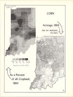
- Topical Subject: SYMAP (Computer program language), Topical Subject: Corn--Geographical distribution, Geographic Subject: Indiana, and Topical Subject: Phyto...
- Creator:
- Hollingsworth, John M., Indiana University. Research Computing Center, and Kingsbury, Robert C.
- Publisher:
- Indiana University. Department of Geography
- Date Created:
- 1970
- Identifier:
- VAC3073-M-00267
- Genre:
- Thematic maps
- Geographic Location:
- Coordinates: W0880700 W0844500 N0414500 N0374600
- Related URL:
- Catalog URL: https://iucat.iu.edu/catalog/15984676
- Abstract:
- Dot distribution map. Includes ancillary computer generated isopleth map Corn as a percent of all cropland, 1964. ASCII-art map created using SYMAP or simila...
- Call Number:
- G4091.J7 1964 .K56
- Caption:
- Imprint: Bloomington, Indiana : Department of Geography, Indiana University, [1970]
- Physical Description:
- Scale: Approximately 1:2,534,400 and Dimensions: 26 x 18 cm, on sheet 28 x 21 cm
- Alternate Identifier:
- Title Control Number: a15984676 and Alternate ID: 317383IP
- Persistent URL:
- https://purl.dlib.indiana.edu/iudl/images/VAC3073/VAC3073-M-00267
- Provenance:
- An atlas of Indiana / by Robert C. Kingsbury [1970].
-
- Subject:
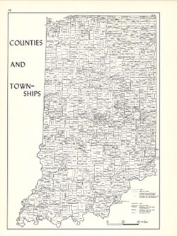
- Geographic Subject: Indiana, Topical Subject: Administrative and political divisions, and Topical Subject: Counties
- Creator:
- Kingsbury, Robert C. and Hollingsworth, John M.
- Publisher:
- Indiana University. Department of Geography
- Date Created:
- 1970
- Identifier:
- VAC3073-M-00412
- Genre:
- Thematic maps
- Geographic Location:
- Coordinates: W0880700 W0844500 N0414500 N0374600
- Related URL:
- Catalog URL: https://iucat.iu.edu/catalog/15942420
- Abstract:
- Shows locations of Indiana counties and townships. Detached from: An atlas of Indiana / by Robert C. Kingsbury , with contributions from John M. Hollings...
- Call Number:
- G4091.F7 1970 .K56
- Caption:
- Imprint: Bloomington, Indiana : Department of Geography, Indiana University, [1970]
- Physical Description:
- Scale: Approximately 1:1,800,000 and Dimensions: 26 x 18 cm, on sheet 28 x 21 cm
- Alternate Identifier:
- Title Control Number: a15942420 and Alternate ID: 317383IP
- Persistent URL:
- https://purl.dlib.indiana.edu/iudl/images/VAC3073/VAC3073-M-00412
- Provenance:
- An atlas of Indiana / by Robert C. Kingsbury [1970].
-
- Subject:
- Topical Subject: SYMAP (Computer program language), Topical Subject: Agricultural resources, Geographic Subject: Indiana, and Topical Subject: Land capabilit...
- Creator:
- Hollingsworth, John M., Kingsbury, Robert C., and Indiana University. Research Computing Center
- Publisher:
- Indiana University. Department of Geography
- Date Created:
- 1970
- Identifier:
- VAC3073-M-00052
- Genre:
- Thematic maps
- Geographic Location:
- Coordinates: W0880700 W0844500 N0414500 N0374600
- Related URL:
- Catalog URL: https://iucat.iu.edu/catalog/15995410
- Abstract:
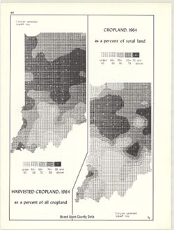
- 2 maps on 1 sheet, Cropland, 1964, as a percent of total land and Harvested cropland, 1964, as a percent of total land. Computer generated isopleth maps obta...
- Call Number:
- G4091.J1 1964 .K56
- Caption:
- Imprint: Bloomington, Indiana : Department of Geography, Indiana University, [1970]
- Physical Description:
- Dimensions: each 26 x 10 cm, on sheet 28 x 21 cm and Scale: Approximately 1:3,000,000
- Alternate Identifier:
- Alternate ID: 317383IP and Title Control Number: a15995410
- Persistent URL:
- https://purl.dlib.indiana.edu/iudl/images/VAC3073/VAC3073-M-00052
- Provenance:
- An atlas of Indiana / by Robert C. Kingsbury [1970].
-
- Subject:
- Topical Subject: Wholesale trade, Topical Subject: Labor supply, and Geographic Subject: Indiana
- Creator:
- Hollingsworth, John M. and Kingsbury, Robert C.
- Publisher:
- Indiana University. Department of Geography
- Date Created:
- 1970
- Identifier:
- VAC3073-M-00715
- Genre:
- Thematic maps
- Geographic Location:
- Coordinates: W0880700 W0844500 N0414500 N0374600
- Related URL:
- Catalog URL: https://iucat.iu.edu/catalog/15987137
- Abstract:
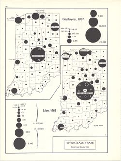
- 2 maps on 1 sheet, Wholesale trade, employees, 1967, and Wholesale trade sales, 1963. Graduated symbol maps. Detached from: An atlas of Indiana / by Rober...
- Call Number:
- G4091.G8 1963 .K58
- Caption:
- Imprint: Bloomington, Indiana : Department of Geography, Indiana University, [1970]
- Physical Description:
- Dimensions: on sheet 28 x 21 cm and Scale: Approximately 1:2,700,000
- Alternate Identifier:
- Title Control Number: a15987137 and Alternate ID: 317383IP
- Persistent URL:
- https://purl.dlib.indiana.edu/iudl/images/VAC3073/VAC3073-M-00715
- Provenance:
- An atlas of Indiana / by Robert C. Kingsbury [1970].
