
Search Constraints
You searched for:
Campus
IUB
Remove constraint Campus: IUB
Creator
Hollingsworth, John M.
Remove constraint Creator: Hollingsworth, John M.
Holding Location
B-WELLS
Remove constraint Holding Location: B-WELLS
Pages
0-99 pages
Remove constraint Pages: 0-99 pages
Search Results
-
- Subject:
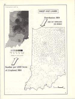
- Geographic Subject: Indiana, Topical Subject: Sheep--Geographical distribution, Topical Subject: SYMAP (Computer program language), and Topical Subject: Lamb...
- Creator:
- Indiana University. Research Computing Center, Hollingsworth, John M., and Kingsbury, Robert C.
- Publisher:
- Indiana University. Department of Geography
- Date Created:
- 1970
- Identifier:
- VAC3073-M-00362
- Genre:
- Thematic maps
- Geographic Location:
- Coordinates: W0880700 W0844500 N0414500 N0374600
- Related URL:
- Catalog URL: https://iucat.iu.edu/catalog/15984670
- Abstract:
- Dot distribution map. Includes ancillary computer generated isopleth map Sheep and lambs: number per 1,000 acres of cropland, 1964. ASCII-art map created usi...
- Call Number:
- G4091.J5 1964 .K58
- Caption:
- Imprint: Bloomington, Indiana : Department of Geography, Indiana University, [1970]
- Physical Description:
- Dimensions: 26 x 18 cm, on sheet 28 x 21 cm and Scale: Approximately 1:2,534,400
- Alternate Identifier:
- Title Control Number: a15984670 and Alternate ID: 317383IP
- Persistent URL:
- https://purl.dlib.indiana.edu/iudl/images/VAC3073/VAC3073-M-00362
- Provenance:
- An atlas of Indiana / by Robert C. Kingsbury [1970].
-
- Subject:
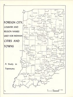
- Topical Subject: Toponymy, Topical Subject: Names, Geographical, and Geographic Subject: Indiana
- Creator:
- Kingsbury, Robert C. and Hollingsworth, John M.
- Publisher:
- Indiana University. Department of Geography
- Date Created:
- 1970
- Identifier:
- VAC3073-M-00355
- Genre:
- Thematic maps
- Geographic Location:
- Coordinates: W0880700 W0844500 N0414500 N0374600
- Related URL:
- Catalog URL: https://iucat.iu.edu/catalog/15948317
- Abstract:
- Detached from: An atlas of Indiana / by Robert C. Kingsbury , with contributions from John M. Hollingsworth and others. Bloomington, Indiana : Department of ...
- Call Number:
- G4091.A8 1960 .K56
- Caption:
- Imprint: Bloomington, Indiana : Department of Geography, Indiana University, [1970]
- Physical Description:
- Dimensions: 26 x 18 cm, on sheet 28 x 21 cm and Scale: Approximately 1:1,950,000
- Alternate Identifier:
- Alternate ID: 317383IP and Title Control Number: a15948317
- Persistent URL:
- https://purl.dlib.indiana.edu/iudl/images/VAC3073/VAC3073-M-00355
- Provenance:
- An atlas of Indiana / by Robert C. Kingsbury [1970].
-
- Subject:
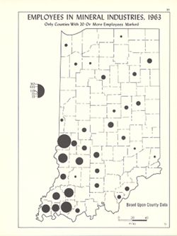
- Topical Subject: Mineral industries--Employees, Geographic Subject: Indiana, and Topical Subject: Labor supply
- Creator:
- Hollingsworth, John M. and Kingsbury, Robert C.
- Publisher:
- Indiana University. Department of Geography
- Date Created:
- 1970
- Identifier:
- VAC3073-M-00332
- Genre:
- Thematic maps
- Geographic Location:
- Coordinates: W0880700 W0844500 N0414500 N0374600
- Related URL:
- Catalog URL: https://iucat.iu.edu/catalog/15941776
- Abstract:
- Graduated symbol map. Shows number of employees by county. Detached from: An atlas of Indiana / by Robert C. Kingsbury , with contributions from John M. H...
- Call Number:
- G4091.G8 1963 .K56
- Caption:
- Imprint: Bloomington, Indiana : Department of Geography, Indiana University, [1970]
- Physical Description:
- Scale: Approximately 1:1,950,000 and Dimensions: 26 x 18 cm, on sheet 28 x 21 cm
- Alternate Identifier:
- Alternate ID: 317383IP and Title Control Number: a15941776
- Persistent URL:
- https://purl.dlib.indiana.edu/iudl/images/VAC3073/VAC3073-M-00332
- Provenance:
- An atlas of Indiana / by Robert C. Kingsbury [1970].
-
- Subject:
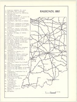
- Topical Subject: Railroads and Geographic Subject: Indiana
- Creator:
- Kingsbury, Robert C. and Hollingsworth, John M.
- Publisher:
- Indiana University. Department of Geography
- Date Created:
- 1970
- Identifier:
- VAC3073-M-00313
- Genre:
- Thematic maps
- Geographic Location:
- Coordinates: W0880700 W0844500 N0414500 N0374600
- Related URL:
- Catalog URL: https://iucat.iu.edu/catalog/15934621
- Abstract:
- Includes index of railroads. Detached from: An atlas of Indiana / by Robert C. Kingsbury , with contributions from John M. Hollingsworth and others. Bloom...
- Call Number:
- G4091.P3 1880 .K56
- Caption:
- Imprint: Bloomington, Indiana : Department of Geography, Indiana University, [1970]
- Physical Description:
- Scale: Approximately 1:2,300,000 and Dimensions: 26 x 18 cm, on sheet 28 x 21 cm
- Alternate Identifier:
- Title Control Number: a15934621 and Alternate ID: 317383IP
- Persistent URL:
- https://purl.dlib.indiana.edu/iudl/images/VAC3073/VAC3073-M-00313
- Provenance:
- An atlas of Indiana / by Robert C. Kingsbury [1970].
-
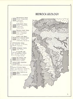
- Subject:
- Topical Subject: Geology, Geographic Subject: Indiana, and Topical Subject: Geology, Structural
- Creator:
- Hollingsworth, John M. and Kingsbury, Robert C.
- Publisher:
- Indiana University. Department of Geography
- Date Created:
- 1970
- Identifier:
- VAC3073-M-00305
- Genre:
- Geological maps
- Geographic Location:
- Coordinates: W0880700 W0844500 N0414500 N0374600
- Related URL:
- Catalog URL: https://iucat.iu.edu/catalog/15939159
- Abstract:
- Includes geological time table. Detached from: An atlas of Indiana / by Robert C. Kingsbury , with contributions from John M. Hollingsworth and others. Bl...
- Call Number:
- G4091.C5 1970 .K57
- Caption:
- Imprint: Bloomington, Indiana : Department of Geography, Indiana University, [1970]
- Physical Description:
- Dimensions: 26 x 18 cm, on sheet 28 x 21 cm and Scale: Approximately 1:2,150,000
- Alternate Identifier:
- Title Control Number: a15939159 and Alternate ID: 317383IP
- Persistent URL:
- https://purl.dlib.indiana.edu/iudl/images/VAC3073/VAC3073-M-00305
- Provenance:
- An atlas of Indiana / by Robert C. Kingsbury [1970].
-
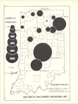
- Subject:
- Topical Subject: Labor supply, Topical Subject: Electric machinery industry--Employees, and Geographic Subject: Indiana
- Creator:
- Kingsbury, Robert C. and Hollingsworth, John M.
- Publisher:
- Indiana University. Department of Geography
- Date Created:
- 1970
- Identifier:
- VAC3073-M-00301
- Genre:
- Thematic maps
- Geographic Location:
- Coordinates: W0880700 W0844500 N0414500 N0374600
- Related URL:
- Catalog URL: https://iucat.iu.edu/catalog/15951253
- Abstract:
- Graduated symbol map. Shows number of employees by county. Detached from: An atlas of Indiana / by Robert C. Kingsbury , with contributions from John M. H...
- Call Number:
- G4091.G8 1967 .K5
- Caption:
- Imprint: Bloomington, Indiana : Department of Geography, Indiana University, [1970]
- Physical Description:
- Dimensions: 26 x 18 cm, on sheet 28 x 21 cm and Scale: Approximately 1:1,950,000
- Alternate Identifier:
- Alternate ID: 317383IP and Title Control Number: a15951253
- Persistent URL:
- https://purl.dlib.indiana.edu/iudl/images/VAC3073/VAC3073-M-00301
- Provenance:
- An atlas of Indiana / by Robert C. Kingsbury [1970].
-
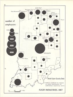
- Subject:
- Topical Subject: Labor supply, Geographic Subject: Indiana, and Topical Subject: Food industry and trade--Employees
- Creator:
- Kingsbury, Robert C. and Hollingsworth, John M.
- Publisher:
- Indiana University. Department of Geography
- Date Created:
- 1970
- Identifier:
- VAC3073-M-00268
- Genre:
- Thematic maps
- Geographic Location:
- Coordinates: W0880700 W0844500 N0414500 N0374600
- Related URL:
- Catalog URL: https://iucat.iu.edu/catalog/15950646
- Abstract:
- Graduated symbol map. Shows number of employees by county. Detached from: An atlas of Indiana / by Robert C. Kingsbury , with contributions from John M. H...
- Call Number:
- G4091.G8 1967 .K59
- Caption:
- Imprint: Bloomington, Indiana : Department of Geography, Indiana University, [1970]
- Physical Description:
- Scale: Approximately 1:1,950,000 and Dimensions: 26 x 18 cm, on sheet 28 x 21 cm
- Alternate Identifier:
- Alternate ID: 317383IP and Title Control Number: a15950646
- Persistent URL:
- https://purl.dlib.indiana.edu/iudl/images/VAC3073/VAC3073-M-00268
- Provenance:
- An atlas of Indiana / by Robert C. Kingsbury [1970].
-
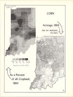
- Subject:
- Topical Subject: SYMAP (Computer program language), Topical Subject: Corn--Geographical distribution, Geographic Subject: Indiana, and Topical Subject: Phyto...
- Creator:
- Hollingsworth, John M., Indiana University. Research Computing Center, and Kingsbury, Robert C.
- Publisher:
- Indiana University. Department of Geography
- Date Created:
- 1970
- Identifier:
- VAC3073-M-00267
- Genre:
- Thematic maps
- Geographic Location:
- Coordinates: W0880700 W0844500 N0414500 N0374600
- Related URL:
- Catalog URL: https://iucat.iu.edu/catalog/15984676
- Abstract:
- Dot distribution map. Includes ancillary computer generated isopleth map Corn as a percent of all cropland, 1964. ASCII-art map created using SYMAP or simila...
- Call Number:
- G4091.J7 1964 .K56
- Caption:
- Imprint: Bloomington, Indiana : Department of Geography, Indiana University, [1970]
- Physical Description:
- Scale: Approximately 1:2,534,400 and Dimensions: 26 x 18 cm, on sheet 28 x 21 cm
- Alternate Identifier:
- Title Control Number: a15984676 and Alternate ID: 317383IP
- Persistent URL:
- https://purl.dlib.indiana.edu/iudl/images/VAC3073/VAC3073-M-00267
- Provenance:
- An atlas of Indiana / by Robert C. Kingsbury [1970].
-
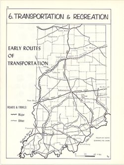
- Subject:
- Topical Subject: Transportation, Geographic Subject: Indiana, and Topical Subject: Historical geography
- Creator:
- Hollingsworth, John M. and Kingsbury, Robert C.
- Publisher:
- Indiana University. Department of Geography
- Date Created:
- 1970
- Identifier:
- VAC3073-M-00255
- Genre:
- Thematic maps
- Geographic Location:
- Coordinates: W0880700 W0844500 N0414500 N0374600
- Related URL:
- Catalog URL: https://iucat.iu.edu/catalog/15937996
- Abstract:
- Shows rivers, canals, roads, trails, and the first Indiana railroad, important transportation routes during the Pioneer Era. Detached from: An atlas of In...
- Call Number:
- G4091.S1 1970 .K56
- Caption:
- Imprint: Bloomington, Indiana : Department of Geography, Indiana University, [1970]
- Physical Description:
- Dimensions: 23 x 18 cm, on sheet 28 x 21 cm and Scale: Approximately 1:2,000,000
- Alternate Identifier:
- Title Control Number: a15937996 and Alternate ID: 317383IP
- Persistent URL:
- https://purl.dlib.indiana.edu/iudl/images/VAC3073/VAC3073-M-00255
- Provenance:
- An atlas of Indiana / by Robert C. Kingsbury [1970].
-
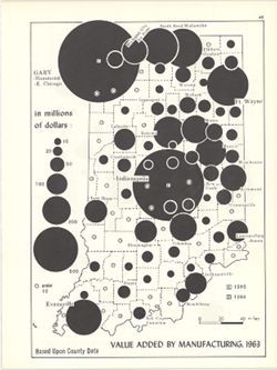
- Subject:
- Topical Subject: Manufacturing industries and Geographic Subject: Indiana
- Creator:
- Kingsbury, Robert C. and Hollingsworth, John M.
- Publisher:
- Indiana University. Department of Geography
- Date Created:
- 1970
- Identifier:
- VAC3073-M-00242
- Genre:
- Thematic maps
- Geographic Location:
- Coordinates: W0880700 W0844500 N0414500 N0374600
- Related URL:
- Catalog URL: https://iucat.iu.edu/catalog/15951308
- Abstract:
- Graduated symbol map. Data shown by county. Detached from: An atlas of Indiana / by Robert C. Kingsbury , with contributions from John M. Hollingsworth an...
- Call Number:
- G4091.M1 1963 .K56
- Caption:
- Imprint: Bloomington, Indiana : Department of Geography, Indiana University, [1970]
- Physical Description:
- Scale: Approximately 1:1,950,000 and Dimensions: 26 x 18 cm, on sheet 28 x 21 cm
- Alternate Identifier:
- Alternate ID: 317383IP and Title Control Number: a15951308
- Persistent URL:
- https://purl.dlib.indiana.edu/iudl/images/VAC3073/VAC3073-M-00242
- Provenance:
- An atlas of Indiana / by Robert C. Kingsbury [1970].
