
Search Constraints
You searched for:
Campus
IUB
Remove constraint Campus: IUB
Date Created
1936
Remove constraint Date Created: 1936
Language
Russian
Remove constraint Language: Russian
1 - 49 of 49
Search Results
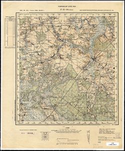
-
- Description:
- 1912
- Subject:
- Topical Subject: Soviet Union, Topical Subject: Maps, and Geographic Subject: Barczewo
- Publisher:
- Генеральный штаб РККА
- Language:
- Russian
- Date Created:
- 1936
- Identifier:
- VAC9619-003945
- Genre:
- Military Maps and Topographic Maps
- Geographic Location:
- Coordinates: 53.667, 20.5, 54, 21
- Related URL:
- Catalog URL: https://iucat.iu.edu/catalog/5020129 and Download GeoTIFF: https://drive.google.com/file/d/185PWwk5iBfaLGgZ2vn8dO60H15umOVmT/view?usp=sharing
- Abstract:
- Modern area represented: Barczewo, Warmia-Masuria, Poland
- Call Number:
- G7000 s100 .S7 sheet N-34-78
- City:
- Вартенбург (Wartenburg)
- Copyright Holder:
- No Copyright - United States
- State/Province:
- Алленштайнская провинция (Allenstein province), Восточная Пруссия (East Prussia), and Кенигсбергская провинция (Königsberg province)
- Physical Description:
- Scale: 1:100,000
- Persistent URL:
- http://purl.dlib.indiana.edu/iudl/images/VAC9619/VAC9619-003945
- Provenance:
- DMA Topographic Center, Army Map Service Library, Atlasblatt
-
- Description:
- 1910
- Subject:
- Topical Subject: Maps, Geographic Subject: Myszyniec, and Topical Subject: Soviet Union
- Publisher:
- Генеральный штаб РККА
- Language:
- Russian
- Date Created:
- 1936
- Identifier:
- VAC9619-003958
- Genre:
- Military Maps and Topographic Maps
- Geographic Location:
- Coordinates: 53.333, 21, 53.667, 21.5
- Related URL:
- Download GeoTIFF: https://drive.google.com/file/d/1B6ZEwsNeUZ6BWE_--ZMSM0vuCXUzT4tV/view?usp=sharing and Catalog URL: https://iucat.iu.edu/catalog/5020129
- Abstract:
- Modern area represented: Myszyniec, Mazovia, Poland
- Call Number:
- G7000 s100 .S7 sheet N-34-91
- City:
- Мышинец (Myszyniec)
- Copyright Holder:
- No Copyright - United States
- Country:
- Германия (Germany)
- State/Province:
- Область государственных интересов Германии (Region of German state interests)
- Physical Description:
- Scale: 1:100,000
- Persistent URL:
- http://purl.dlib.indiana.edu/iudl/images/VAC9619/VAC9619-003958
- Provenance:
- DMA Topographic Center, Army Map Service Library
-
- Description:
- 1916
- Subject:
- Geographic Subject: Janowo, Topical Subject: Maps, and Topical Subject: Soviet Union
- Publisher:
- Генеральный штаб РККА
- Language:
- Russian
- Date Created:
- 1936
- Identifier:
- VAC9619-003959
- Genre:
- Topographic Maps and Military Maps
- Geographic Location:
- Coordinates: 53.333, 21.5, 53.667, 22
- Related URL:
- Catalog URL: https://iucat.iu.edu/catalog/5020129 and Download GeoTIFF: https://drive.google.com/file/d/1V9_BtRhfFGWhUMbvWGMSthlnHu_vi1pv/view?usp=sharing
- Abstract:
- Modern area represented: Janowo, Warmia-Masuria, Poland
- Call Number:
- G7000 s100 .S7 sheet N-34-92
- City:
- Иоганнисбург (Johannisberg)
- Copyright Holder:
- No Copyright - United States
- Country:
- СССР (USSR) and Германия (Germany)
- State/Province:
- Белорусская ССР (Byelorussian Soviet Socialist Republic), Область государственных интересов Германии (Region of German state interests), and Белостокская обл...
- Physical Description:
- Scale: 1:100,000
- Persistent URL:
- http://purl.dlib.indiana.edu/iudl/images/VAC9619/VAC9619-003959
- Provenance:
- DMA Topographic Center, Army Map Service Library
-
- Description:
- 1929
- Subject:
- Topical Subject: Maps, Geographic Subject: Olsztynek, and Topical Subject: Soviet Union
- Publisher:
- Генеральный штаб РККА
- Language:
- Russian
- Date Created:
- 1936
- Identifier:
- VAC9619-003956
- Genre:
- Military Maps and Topographic Maps
- Geographic Location:
- Coordinates: 53.333, 20, 53.667, 20.5
- Related URL:
- Download GeoTIFF: https://drive.google.com/file/d/1buUda318Lq2zsO4SHgHXZckJJuRy45vx/view?usp=sharing and Catalog URL: https://iucat.iu.edu/catalog/5020129
- Abstract:
- Modern area represented: Olsztynek, Warmia-Masuria, Poland
- Call Number:
- G7000 s100 .S7 sheet N-34-89
- City:
- Хохенштайн (Hohenstein)
- Copyright Holder:
- No Copyright - United States
- Country:
- Германия (Germany)
- Physical Description:
- Scale: 1:100,000
- Persistent URL:
- http://purl.dlib.indiana.edu/iudl/images/VAC9619/VAC9619-003956
- Provenance:
- DMA Topographic Center, Army Map Service Library, OMAHA
-
- Description:
- 1929
- Subject:
- Topical Subject: Maps, Topical Subject: Soviet Union, and Geographic Subject: Przasnysz
- Publisher:
- Генеральный штаб РККА
- Language:
- Russian
- Date Created:
- 1936
- Identifier:
- VAC9619-003968
- Genre:
- Military Maps and Topographic Maps
- Geographic Location:
- Coordinates: 53, 20.5, 53.333, 21
- Related URL:
- Catalog URL: https://iucat.iu.edu/catalog/5020129 and Download GeoTIFF: https://drive.google.com/file/d/1lSBsKEQj_ti2B2TCzPMbQsf-4n3GFsZO/view?usp=sharing
- Abstract:
- Modern area represented: Przasnysz, Masovian Voivodship, Poland
- Call Number:
- G7000 s100 .S7 sheet N-34-102
- City:
- Пжасныш (Przasnysz)
- Copyright Holder:
- No Copyright - United States
- Country:
- Германия (Germany)
- State/Province:
- Область государственных интересов Германии (Region of German state interests)
- Physical Description:
- Scale: 1:100,000
- Persistent URL:
- http://purl.dlib.indiana.edu/iudl/images/VAC9619/VAC9619-003968
- Provenance:
- DMA Topographic Center, Army Map Service Library, Auswärtiges Amt. Geographischer Dienst
-
- Description:
- 1931
- Subject:
- Topical Subject: Soviet Union, Geographic Subject: Vetchin, and Topical Subject: Maps
- Publisher:
- Генеральный штаб РККА
- Language:
- Russian
- Date Created:
- 1936
- Identifier:
- VAC9619-004131
- Genre:
- Military Maps and Topographic Maps
- Geographic Location:
- Coordinates: 52.333, 28, 52.667, 28.5
- Related URL:
- Download GeoTIFF: https://drive.google.com/file/d/1BObtNuYZnAxZI3mOsfkM-U1WvTF8g2ht/view?usp=sharing and Catalog URL: https://iucat.iu.edu/catalog/5020129
- Abstract:
- Modern area represented: Vetchin, Homyel oblast, Belarus
- Call Number:
- G7000 s100 .S7 sheet N-35-129
- Caption:
- Не подлежит оглашению
- City:
- Витчины (Vetchin)
- Copyright Holder:
- No Copyright - United States
- Country:
- СССР (USSR)
- State/Province:
- Белорусская ССР (Byelorussian Soviet Socialist Republic), Минская область (Minsk oblast), and Полесская область (Polesia oblast)
- Physical Description:
- Scale: 1:100,000
- Persistent URL:
- http://purl.dlib.indiana.edu/iudl/images/VAC9619/VAC9619-004131
- Provenance:
- DMA Topographic Center, Army Map Service Library, OMAHA, Atlasblatt
-
- Description:
- 1933
- Subject:
- Topical Subject: Maps, Geographic Subject: Zembin, and Topical Subject: Soviet Union
- Publisher:
- Генеральный штаб РККА
- Language:
- Russian
- Date Created:
- 1936
- Identifier:
- VAC9619-004059
- Genre:
- Topographic Maps and Military Maps
- Geographic Location:
- Coordinates: 54.333, 28, 54.667, 28.5
- Related URL:
- Download GeoTIFF: https://drive.google.com/file/d/1eyeaCvD_WB_ldiVhTdQEx3lFGbJSMGoz/view?usp=sharing and Catalog URL: https://iucat.iu.edu/catalog/5020129
- Abstract:
- Modern area represented: Zembin, Belarus
- Call Number:
- G7000 s100 .S7 sheet N-35-57
- Caption:
- Не подлежит оглашению
- City:
- Зембин (Zembin)
- Copyright Holder:
- No Copyright - United States
- Country:
- СССР (USSR)
- State/Province:
- Минская область (Minsk oblast) and Белорусская ССР (Byelorussian Soviet Socialist Republic)
- Physical Description:
- Scale: 1:100,000
- Persistent URL:
- http://purl.dlib.indiana.edu/iudl/images/VAC9619/VAC9619-004059
- Provenance:
- DMA Topographic Center, Army Map Service Library, OMAHA
-
- Description:
- 1887
- Subject:
- Topical Subject: Maps, Geographic Subject: Dąbrowa Białostocka, and Topical Subject: Soviet Union
- Publisher:
- Генеральный штаб РККА
- Language:
- Russian
- Date Created:
- 1936
- Identifier:
- VAC9619-003961
- Genre:
- Military Maps and Topographic Maps
- Geographic Location:
- Coordinates: 53.333, 23, 53.667, 23.5
- Related URL:
- Catalog URL: https://iucat.iu.edu/catalog/5020129 and Download GeoTIFF: https://drive.google.com/file/d/1S4yPZX7mnO1ThQsSs1pyq1my1dxl968Q/view?usp=sharing
- Abstract:
- Modern area represented: Dąbrowa Białostocka, Podlasie, Poland
- Call Number:
- G7000 s100 .S7 sheet N-34-95
- City:
- Домброва (Dąbrowa)
- Copyright Holder:
- No Copyright - United States
- Country:
- СССР (USSR)
- State/Province:
- Белостокская область (Belastok oblast) and Белорусская ССР (Byelorussian Soviet Socialist Republic)
- Physical Description:
- Scale: 1:100,000
- Persistent URL:
- http://purl.dlib.indiana.edu/iudl/images/VAC9619/VAC9619-003961
- Provenance:
- DMA Topographic Center, Army Map Service Library
-
- Description:
- 1914
- Subject:
- Topical Subject: Maps, Topical Subject: Soviet Union, and Geographic Subject: Szczytno
- Publisher:
- Генеральный штаб РККА
- Language:
- Russian
- Date Created:
- 1936
- Identifier:
- VAC9619-003957
- Genre:
- Topographic Maps and Military Maps
- Geographic Location:
- Coordinates: 53.333, 20.5, 53.667, 21
- Related URL:
- Catalog URL: https://iucat.iu.edu/catalog/5020129 and Download GeoTIFF: https://drive.google.com/file/d/1PGwif-x5nWuOwkHqZXDxeLjCMtPziPN9/view?usp=sharing
- Abstract:
- Modern area represented: Szczytno, Warmia-Masuria, Poland
- Call Number:
- G7000 s100 .S7 sheet N-34-90
- City:
- Ортельсбург (Ortelsburg)
- Copyright Holder:
- No Copyright - United States
- Country:
- Германия (Germany)
- State/Province:
- Область государственных интересов Германии (Region of German state interests)
- Physical Description:
- Scale: 1:100,000
- Persistent URL:
- http://purl.dlib.indiana.edu/iudl/images/VAC9619/VAC9619-003957
- Provenance:
- DMA Topographic Center, Army Map Service Library
-
- Description:
- 1909
- Subject:
- Topical Subject: Maps, Topical Subject: Soviet Union, and Geographic Subject: Prabuty
- Publisher:
- Генеральный штаб Красной Армии
- Language:
- Russian
- Date Created:
- 1936
- Identifier:
- VAC9619-003943
- Genre:
- Military Maps and Topographic Maps
- Geographic Location:
- Coordinates: 53.667, 19, 54, 19.5
- Related URL:
- Download GeoTIFF: https://drive.google.com/file/d/11wrXv_QkIHayrpXhFrfMGiRwtV1AXijK/view?usp=sharing and Catalog URL: https://iucat.iu.edu/catalog/5020129
- Abstract:
- Modern area represented: Prabuty, Pomerania, Poland
- Call Number:
- G7000 s100 .S7 sheet N-34-75
- City:
- Ризенбург (Riesenburg)
- Copyright Holder:
- No Copyright - United States
- Country:
- Германия (Germany)
- State/Province:
- Восточная Пруссия (East Prussia)
- Physical Description:
- Scale: 1:100,000
- Persistent URL:
- http://purl.dlib.indiana.edu/iudl/images/VAC9619/VAC9619-003943
- Provenance:
- DMA Topographic Center, Army Map Service Library, OMAHA
-
- Description:
- 1909
- Subject:
- Geographic Subject: Stavropol’ Krai, Topical Subject: Maps, Topical Subject: Soviet Union, and Geographic Subject: Pyatigorsk
- Publisher:
- Управление военных топографов РККА
- Language:
- Russian
- Date Created:
- 1936
- Identifier:
- VAC9619-002242
- Genre:
- Military Maps and Topographic Maps
- Geographic Location:
- Coordinates: 44, 43, 44.3333, 43.5
- Related URL:
- Download GeoTIFF: https://drive.google.com/file/d/1b87g1ffiH5tUIIxMUlRAMC1SpRo9sRtq/view?usp=sharing and Catalog URL: https://iucat.iu.edu/catalog/5020129
- Abstract:
- Modern area represented: Пятигорск (Pyatigorsk), Stavropol’ Krai, Russia
- Call Number:
- G7000 s100 .S7 sheet L-38-135
- Caption:
- Для cлужебного пользования
- City:
- Пятигорск (Pyatigorsk)
- Copyright Holder:
- No Copyright - United States
- Country:
- СССР (USSR)
- State/Province:
- Орджоникидзевский край (Ordzhonikidze kray) and РСФСР (RSFSR)
- Physical Description:
- Scale: 1:100,000
- Persistent URL:
- http://purl.dlib.indiana.edu/iudl/images/VAC9619/VAC9619-002242
- Provenance:
- DMA Topographic Center, Army Map Service Library
-
- Description:
- 1904
- Subject:
- Topical Subject: Maps, Topical Subject: Soviet Union, and Geographic Subject: Dzyaniskavichy
- Publisher:
- Генеральный штаб РККА
- Language:
- Russian
- Date Created:
- 1936
- Identifier:
- VAC9619-004118
- Genre:
- Topographic Maps and Military Maps
- Geographic Location:
- Coordinates: 52.667, 26.5, 53, 27
- Related URL:
- Download GeoTIFF: https://drive.google.com/file/d/1GVxOrmstQScVR3TCgfspXEaC8y2HGze_/view?usp=sharing and Catalog URL: https://iucat.iu.edu/catalog/5020129
- Abstract:
- Modern area represented: Dzyaniskavichy, Brest oblast, Belarus
- Call Number:
- G7000 s100 .S7 sheet N-35-114
- Caption:
- Не подлежит оглашению
- City:
- Денисковиче (Deniskovichi)
- Copyright Holder:
- No Copyright - United States
- Country:
- Польша (Poland) and СССР (USSR)
- State/Province:
- Белорусская ССР (Byelorussian Soviet Socialist Republic)
- Physical Description:
- Scale: 1:100,000
- Persistent URL:
- http://purl.dlib.indiana.edu/iudl/images/VAC9619/VAC9619-004118
- Provenance:
- DMA Topographic Center, Army Map Service Library, OMAHA
-
- Description:
- 1913
- Subject:
- Geographic Subject: Baldzhikan, Topical Subject: Maps, and Topical Subject: Soviet Union
- Publisher:
- Управление военных топографов РККА
- Language:
- Russian
- Date Created:
- 1936
- Identifier:
- VAC9619-003551
- Genre:
- Topographic Maps and Military Maps
- Geographic Location:
- Coordinates: 49, 110, 49.333, 110.5
- Related URL:
- Download GeoTIFF: https://drive.google.com/file/d/1EDdpb1Qpq4XTzjSQ3wYTtMmQ_tYdDFSv/view?usp=sharing and Catalog URL: https://iucat.iu.edu/catalog/5020129
- Abstract:
- Modern area represented: Baldzhikan, Transbaikal territory, Russia
- Call Number:
- G7000 s100 .S7 sheet M-49-101
- Caption:
- Не подлежит оглашению
- City:
- Бальджикан (Baldzhikan)
- Copyright Holder:
- No Copyright - United States
- Country:
- СССР (USSR)
- State/Province:
- РСФСР (RSFSR) and Читинская область (Chita oblast)
- Physical Description:
- Scale: 1:100,000
- Persistent URL:
- http://purl.dlib.indiana.edu/iudl/images/VAC9619/VAC9619-003551
- Provenance:
- Library of Congress G & M Division, University of Kansas Map Library
-
- Description:
- 1924
- Subject:
- Topical Subject: Maps, Geographic Subject: Omut, and Topical Subject: Soviet Union
- Publisher:
- Управление военных топографов РККА
- Language:
- Russian
- Date Created:
- 1936
- Identifier:
- VAC9619-000020
- Genre:
- Military Maps and Topographic Maps
- Geographic Location:
- Coordinates: 59, 27.75, 59.167, 28
- Related URL:
- Download GeoTIFF: https://drive.google.com/open?id=1x6coF_bFqa5VyWZ_JSrewAbtpu4RSn_0 and Catalog URL: http://iucat.iu.edu/catalog/5020131
- Abstract:
- Modern area represented: Omut, Russia
- Call Number:
- G7000 s50 .S68 sheet O-35-32-D
- Caption:
- Секретно,Captured map
- City:
- Омути (Omut)
- Copyright Holder:
- No Copyright - United States
- Country:
- СССР (USSR) and Эстония (Estonia)
- State/Province:
- РСФСР (RSFSR) and Ленинградская область (Leningrad oblast)
- Physical Description:
- Scale: 1:50,000
- Persistent URL:
- http://purl.dlib.indiana.edu/iudl/images/VAC9619/VAC9619-000020
- Provenance:
- Army Map Service Library, OMAHA, Library of Congress Geography & Map Division
-
- Description:
- 1933
- Subject:
- Topical Subject: Soviet Union, Geographic Subject: Smilavichy, and Topical Subject: Maps
- Publisher:
- Управление военных топографов РККА
- Language:
- Russian
- Date Created:
- 1936
- Identifier:
- VAC9619-004081
- Genre:
- Military Maps and Topographic Maps
- Geographic Location:
- Coordinates: 53.667, 28, 54, 28.5
- Related URL:
- Download GeoTIFF: https://drive.google.com/file/d/1H8FweVO9LnHfFCQ6pbRGNdMLVVsrPnp4/view?usp=sharing and Catalog URL: https://iucat.iu.edu/catalog/5020129
- Abstract:
- Modern area represented: Smilavichy, Belarus
- Call Number:
- G7000 s100 .S7 sheet N-35-81
- Caption:
- Не подлежит оглашению
- City:
- Смиловичи (Smilavichy)
- Copyright Holder:
- No Copyright - United States
- Country:
- СССР (USSR)
- State/Province:
- Белорусская ССР (Byelorussian Soviet Socialist Republic)
- Physical Description:
- Scale: 1:100,000
- Persistent URL:
- http://purl.dlib.indiana.edu/iudl/images/VAC9619/VAC9619-004081
- Provenance:
- Library of Congress G & M Division
-
- Description:
- 1910
- Subject:
- Topical Subject: Maps, Geographic Subject: Zapovednoye, and Topical Subject: Soviet Union
- Publisher:
- Генеральный штаб Красной Армии
- Language:
- Russian
- Date Created:
- 1936
- Identifier:
- VAC9619-003906
- Genre:
- Topographic Maps and Military Maps
- Geographic Location:
- Coordinates: 55, 21, 55.333, 21.5
- Related URL:
- Download GeoTIFF: https://drive.google.com/file/d/12PGTJmL4tGlewGrgQWYN2tWFAn2nnWfT/view?usp=sharing and Catalog URL: https://iucat.iu.edu/catalog/5020129
- Abstract:
- Modern area represented: Zapovednoye, Kaliningrad, Russia
- Call Number:
- G7000 s100 .S7 sheet N-34-31
- City:
- Зекенбург (Zekenborg)
- Copyright Holder:
- No Copyright - United States
- Country:
- Германия (Germany)
- State/Province:
- Восточная Пруссия (East Prussia)
- Physical Description:
- Scale: 1:100,000
- Persistent URL:
- http://purl.dlib.indiana.edu/iudl/images/VAC9619/VAC9619-003906
- Provenance:
- DMA Topographic Center, Army Map Service Library, OMAHA
-
- Description:
- 1904
- Subject:
- Topical Subject: Soviet Union, Topical Subject: Maps, and Geographic Subject: Kiyevichi
- Publisher:
- Управление военных топографов РККА
- Language:
- Russian
- Date Created:
- 1936
- Identifier:
- VAC9619-000708
- Genre:
- Military Maps and Topographic Maps
- Geographic Location:
- Coordinates: 52.833, 26.75, 53, 27
- Related URL:
- Catalog URL: http://iucat.iu.edu/catalog/5020131 and Download GeoTIFF: https://drive.google.com/open?id=1tTKI474LW2kDomqmBh1_w15EeaX7m8st
- Abstract:
- Modern area represented: Kiyevichi, Minsk oblast, Belarus
- Call Number:
- GM G7000 s50 .S68 N-35-114-Б
- Caption:
- Не подлежит оглашению
- City:
- Киевичи (Kiyevichi)
- Copyright Holder:
- No Copyright - United States
- Country:
- СССР (USSR) and Польша (Poland)
- State/Province:
- Белорусская ССР (Byelorussian Soviet Socialist Republic)
- Physical Description:
- Scale: 1:50,000
- Persistent URL:
- http://purl.dlib.indiana.edu/iudl/images/VAC9619/VAC9619-000708
- Provenance:
- Army Map Service Library, Auswärtiges Amt. Geographischer Dienst, OMAHA, Library of Congress Geography & Map Division
-
- Description:
- 1933
- Subject:
- Topical Subject: Maps, Geographic Subject: Shatsk, and Topical Subject: Soviet Union
- Publisher:
- Генеральный штаб РККА
- Language:
- Russian
- Date Created:
- 1936
- Identifier:
- VAC9619-004092
- Genre:
- Military Maps and Topographic Maps
- Geographic Location:
- Coordinates: 53.333, 27.5, 53.667, 28
- Related URL:
- Download GeoTIFF: https://drive.google.com/file/d/1W8MNEo5y754eevSB-hwsnv2-f7tD5UaP/view?usp=sharing and Catalog URL: https://iucat.iu.edu/catalog/5020129
- Abstract:
- Modern area represented: Shatsk, Minsk oblast, Belarus
- Call Number:
- G7000 s100 .S7 sheet N-35-92
- Caption:
- Не подлежит оглашению
- City:
- Шацк (Shatsk)
- Copyright Holder:
- No Copyright - United States
- Country:
- СССР (USSR)
- State/Province:
- Белорусская ССР (Byelorussian Soviet Socialist Republic)
- Physical Description:
- Scale: 1:100,000
- Persistent URL:
- http://purl.dlib.indiana.edu/iudl/images/VAC9619/VAC9619-004092
- Provenance:
- DMA Topographic Center, Army Map Service Library, OMAHA
-
- Description:
- 1917
- Subject:
- Topical Subject: Soviet Union, Topical Subject: Maps, and Geographic Subject: Moroch
- Publisher:
- Управление военных топографов РККА
- Language:
- Russian
- Date Created:
- 1936
- Identifier:
- VAC9619-004130
- Genre:
- Topographic Maps and Military Maps
- Geographic Location:
- Coordinates: 52.333, 27.5, 52.667, 28
- Related URL:
- Catalog URL: https://iucat.iu.edu/catalog/5020129 and Download GeoTIFF: https://drive.google.com/file/d/1HUuzBKcEpGGkMff5L63dHETUlsQCusTP/view?usp=sharing
- Abstract:
- Modern area represented: Moroch, Minsk oblast, Belarus
- Call Number:
- G7000 s100 .S7 sheet N-35-128
- Caption:
- Не подлежит оглашению
- City:
- Морочь (Moroch)
- Copyright Holder:
- No Copyright - United States
- Country:
- Польша (Poland) and СССР (USSR)
- State/Province:
- Белорусская ССР (Byelorussian Soviet Socialist Republic)
- Physical Description:
- Scale: 1:100,000
- Persistent URL:
- http://purl.dlib.indiana.edu/iudl/images/VAC9619/VAC9619-004130
- Provenance:
- DMA Topographic Center, Army Map Service Library
-
- Description:
- 1911
- Subject:
- Geographic Subject: Lubawa, Topical Subject: Soviet Union, and Topical Subject: Maps
- Publisher:
- Генеральный штаб РККА
- Language:
- Russian
- Date Created:
- 1936
- Identifier:
- VAC9619-003955
- Genre:
- Topographic Maps and Military Maps
- Geographic Location:
- Coordinates: 53.333, 19.5, 53.667, 20
- Related URL:
- Catalog URL: https://iucat.iu.edu/catalog/5020129 and Download GeoTIFF: https://drive.google.com/file/d/1T8Q9d-qnPW0VZuYvESGyginsS0dOibxj/view?usp=sharing
- Abstract:
- Modern area represented: Lubawa, Warmia-Masuria, Poland
- Call Number:
- G7000 s100 .S7 sheet N-34-88
- City:
- Любава (Lubawa)
- Copyright Holder:
- No Copyright - United States
- Country:
- Германия (Germany)
- Physical Description:
- Scale: 1:100,000
- Persistent URL:
- http://purl.dlib.indiana.edu/iudl/images/VAC9619/VAC9619-003955
- Provenance:
- DMA Topographic Center, Army Map Service Library
-
- Description:
- 1909
- Subject:
- Topical Subject: Maps, Geographic Subject: Brodnica, and Topical Subject: Soviet Union
- Publisher:
- Генеральный штаб Красной Армии
- Language:
- Russian
- Date Created:
- 1936
- Identifier:
- VAC9619-003965
- Genre:
- Topographic Maps and Military Maps
- Geographic Location:
- Coordinates: 53, 19, 53.333, 19.5
- Related URL:
- Catalog URL: https://iucat.iu.edu/catalog/5020129 and Download GeoTIFF: https://drive.google.com/file/d/1WTl257lAeN5jlVeMHXHj8RTx047zVJKP/view?usp=sharing
- Abstract:
- Modern area represented: Brodnica, Kujawsko-Pomorskie, Poland
- Call Number:
- G7000 s100 .S7 sheet N-34-99
- City:
- Бродница (Brodnica)
- Copyright Holder:
- No Copyright - United States
- Country:
- Германия (Germany)
- State/Province:
- Область государственных интересов Германии (Region of German state interests)
- Physical Description:
- Scale: 1:100,000
- Persistent URL:
- http://purl.dlib.indiana.edu/iudl/images/VAC9619/VAC9619-003965
- Provenance:
- DMA Topographic Center, Army Map Service Library, Auswärtiges Amt. Geographischer Dienst
-
- Description:
- 1886
- Subject:
- Topical Subject: Soviet Union, Geographic Subject: Volkovysk, and Topical Subject: Maps
- Publisher:
- Генеральный штаб РККА
- Language:
- Russian
- Date Created:
- 1936
- Identifier:
- VAC9619-004097
- Genre:
- Topographic Maps and Military Maps
- Geographic Location:
- Coordinates: 53, 24, 53.333, 24.5
- Related URL:
- Catalog URL: https://iucat.iu.edu/catalog/5020129 and Download GeoTIFF: https://drive.google.com/file/d/18doR2e64Wam1zdT6cb0QWTKb53UexOp_/view?usp=sharing
- Abstract:
- Modern area represented: Volkovysk, Belarus
- Call Number:
- G7000 s100 .S7 sheet N-35-97
- City:
- Волковыск (Volkovysk)
- Copyright Holder:
- No Copyright - United States
- Country:
- СССР (USSR)
- State/Province:
- Белорусская ССР (Byelorussian Soviet Socialist Republic) and Белостокская область (Belastok oblast)
- Physical Description:
- Scale: 1:100,000
- Persistent URL:
- http://purl.dlib.indiana.edu/iudl/images/VAC9619/VAC9619-004097
- Provenance:
- DMA Topographic Center, Army Map Service Library, OMAHA
-
- Description:
- 1884
- Subject:
- Topical Subject: Maps, Geographic Subject: Tykocin, and Topical Subject: Soviet Union
- Publisher:
- Генеральный штаб РККА
- Language:
- Russian
- Date Created:
- 1936
- Identifier:
- VAC9619-003971
- Genre:
- Topographic Maps and Military Maps
- Geographic Location:
- Coordinates: 53, 22.5, 53.333, 23
- Related URL:
- Download GeoTIFF: https://drive.google.com/file/d/13GJbr0iKpG6BZoq83ojCBTGCyocZMb2V/view?usp=sharing and Catalog URL: https://iucat.iu.edu/catalog/5020129
- Abstract:
- Modern area represented: Tykocin, Podlaskie Voivodeship, Poland
- Call Number:
- G7000 s100 .S7 sheet N-34-106
- City:
- Тыкоцин (Tykocin)
- Copyright Holder:
- No Copyright - United States
- Country:
- СССР (USSR)
- State/Province:
- Белорусская ССР (Byelorussian Soviet Socialist Republic) and Белостокская область (Belastok oblast)
- Physical Description:
- Scale: 1:100,000
- Persistent URL:
- http://purl.dlib.indiana.edu/iudl/images/VAC9619/VAC9619-003971
- Provenance:
- DMA Topographic Center, Army Map Service Library, Auswärtiges Amt. Geographischer Dienst
-
- Description:
- 1910
- Subject:
- Geographic Subject: Dokšycy, Topical Subject: Maps, and Topical Subject: Soviet Union
- Publisher:
- Генеральный штаб РККА
- Language:
- Russian
- Date Created:
- 1936
- Identifier:
- VAC9619-004046
- Genre:
- Military Maps and Topographic Maps
- Geographic Location:
- Coordinates: 54.667, 27.5, 55, 28
- Related URL:
- Download GeoTIFF: https://drive.google.com/file/d/1RIhM6v61skSqVLQ5MvoPneKh22kofdkL/view?usp=sharing and Catalog URL: https://iucat.iu.edu/catalog/5020129
- Abstract:
- Modern area represented: Dokšycy, Belarus
- Call Number:
- G7000 s100 .S7 sheet N-35-44
- Caption:
- Не подлежит оглашению
- City:
- Докшыце (Dokšycy)
- Copyright Holder:
- No Copyright - United States
- Country:
- СССР (USSR)
- State/Province:
- Белорусская ССР (Byelorussian Soviet Socialist Republic)
- Physical Description:
- Scale: 1:100,000
- Persistent URL:
- http://purl.dlib.indiana.edu/iudl/images/VAC9619/VAC9619-004046
- Provenance:
- DMA Topographic Center, Army Map Service Library, OMAHA, Library of Congress Geography & Map Division
-
- Description:
- 1922
- Subject:
- Geographic Subject: Szczuczyn, Topical Subject: Maps, and Topical Subject: Soviet Union
- Publisher:
- Генеральный штаб РККА
- Language:
- Russian
- Date Created:
- 1936
- Identifier:
- VAC9619-003960
- Genre:
- Military Maps and Topographic Maps
- Geographic Location:
- Coordinates: 53.333, 22, 53.667, 22.5
- Related URL:
- Catalog URL: https://iucat.iu.edu/catalog/5020129 and Download GeoTIFF: https://drive.google.com/file/d/1x55tn0y3lblxyZAejcN6GNjNfT9tjLHc/view?usp=sharing
- Abstract:
- Modern area represented: Szczuczyn, Podlasie, Poland
- Call Number:
- G7000 s100 .S7 sheet N-34-93
- City:
- Щучын (Szczuczyn)
- Copyright Holder:
- No Copyright - United States
- Country:
- Германия (Germany) and СССР (USSR)
- State/Province:
- Белорусская ССР (Byelorussian Soviet Socialist Republic)
- Physical Description:
- Scale: 1:100,000
- Persistent URL:
- http://purl.dlib.indiana.edu/iudl/images/VAC9619/VAC9619-003960
- Provenance:
- DMA Topographic Center, Army Map Service Library, OMAHA
-
- Description:
- 1926
- Subject:
- Geographic Subject: Bogolyubovo, Topical Subject: Maps, and Topical Subject: Soviet Union
- Publisher:
- Управление военных топографов РККА
- Language:
- Russian
- Date Created:
- 1936
- Identifier:
- VAC9619-002277
- Genre:
- Military Maps and Topographic Maps
- Geographic Location:
- Coordinates: 56, 40.5, 56.3333, 41
- Related URL:
- Catalog URL: https://iucat.iu.edu/catalog/5020129 and Download GeoTIFF: https://drive.google.com/file/d/1SHfpY_bvxn3mGrdoWhgp-cce8fDpxMR3/view?usp=sharing
- Abstract:
- Modern area represented: Bogolyubovo, Russia
- Call Number:
- G7000 s100 .S7 sheet O-37-142
- City:
- Боголюбово (Bogolyubovo)
- Copyright Holder:
- No Copyright - United States
- Country:
- СССР (USSR)
- State/Province:
- РСФСР (RSFSR) and Ивановская область (Ivanovo oblast)
- Physical Description:
- Scale: 1:100,000
- Persistent URL:
- http://purl.dlib.indiana.edu/iudl/images/VAC9619/VAC9619-002277
- Provenance:
- DMA Topographic Center, Army Map Service Library, OMAHA, Library of Congress Geography & Map Division
-
- Description:
- 1920
- Subject:
- Geographic Subject: Bolshakovo, Topical Subject: Maps, and Topical Subject: Soviet Union
- Publisher:
- Генеральный штаб РККА
- Language:
- Russian
- Date Created:
- 1936
- Identifier:
- VAC9619-003914
- Genre:
- Military Maps and Topographic Maps
- Geographic Location:
- Coordinates: 54.667, 21.5, 55, 22
- Related URL:
- Download GeoTIFF: https://drive.google.com/file/d/1HTXABmVBVJffTOGd1b-WFxbgo4juGpLL/view?usp=sharing and Catalog URL: https://iucat.iu.edu/catalog/5020129
- Abstract:
- Modern area represented: Bolshakovo, Kaliningrad oblast, Russia
- Call Number:
- G7000 s100 .S7 sheet N-34-44
- City:
- Гр. Скайсгиррен (Groß Skaisgirren)
- Copyright Holder:
- No Copyright - United States
- State/Province:
- Кенигсбергская провинция (Königsberg province) and Восточная Пруссия (East Prussia)
- Physical Description:
- Scale: 1:100,000
- Persistent URL:
- http://purl.dlib.indiana.edu/iudl/images/VAC9619/VAC9619-003914
- Provenance:
- DMA Topographic Center, Army Map Service Library, OMAHA
-

- Description:
- 1916
- Subject:
- Topical Subject: Maps, Topical Subject: Soviet Union, and Geographic Subject: Kublichi
- Publisher:
- Генеральный штаб РККА
- Language:
- Russian
- Date Created:
- 1936
- Identifier:
- VAC9619-004036
- Genre:
- Topographic Maps and Military Maps
- Geographic Location:
- Coordinates: 55, 28, 55.333, 28.5
- Related URL:
- Download GeoTIFF: https://drive.google.com/file/d/1qwv3V7xq3-ylgCjFe9t0yig5IBNmZ15V/view?usp=sharing and Catalog URL: https://iucat.iu.edu/catalog/5020129
- Abstract:
- Modern area represented: Kublichi, Vitebsk oblast, Belarus
- Call Number:
- G7000 s100 .S7 sheet N-35-33
- Caption:
- Не подлежит оглашению
- City:
- Кубличи (Kublichi)
- Copyright Holder:
- No Copyright - United States
- Country:
- Польша (Poland) and СССР (USSR)
- State/Province:
- Витебская область (Vitebsk oblast) and Белорусская ССР (Byelorussian Soviet Socialist Republic)
- Physical Description:
- Scale: 1:100,000
- Persistent URL:
- http://purl.dlib.indiana.edu/iudl/images/VAC9619/VAC9619-004036
- Provenance:
- DMA Topographic Center, Army Map Service Library
-
- Description:
- 1934
- Subject:
- Topical Subject: Maps, Geographic Subject: Kholopenichi, and Topical Subject: Soviet Union
- Publisher:
- Генеральный штаб РККА
- Language:
- Russian
- Date Created:
- 1936
- Identifier:
- VAC9619-004060
- Genre:
- Topographic Maps and Military Maps
- Geographic Location:
- Coordinates: 54.333, 28.5, 54.667, 29
- Related URL:
- Download GeoTIFF: https://drive.google.com/file/d/1onjuqrKcfu2cD0BzmRZ9pHaNVRSwX1oU/view?usp=sharing and Catalog URL: https://iucat.iu.edu/catalog/5020129
- Abstract:
- Modern area represented: Kholopenichi, Belarus
- Call Number:
- G7000 s100 .S7 sheet N-35-58
- Caption:
- Не подлежит оглашению
- City:
- Холопеничи (Kholopenichi)
- Copyright Holder:
- No Copyright - United States
- Country:
- СССР (USSR)
- State/Province:
- Белорусская ССР (Byelorussian Soviet Socialist Republic)
- Physical Description:
- Scale: 1:100,000
- Persistent URL:
- http://purl.dlib.indiana.edu/iudl/images/VAC9619/VAC9619-004060
- Provenance:
- DMA Topographic Center, Army Map Service Library
-
- Description:
- 1903
- Subject:
- Topical Subject: Maps, Topical Subject: Soviet Union, and Geographic Subject: Pastavy
- Publisher:
- Генеральный штаб Красной Армии
- Language:
- Russian
- Date Created:
- 1936
- Identifier:
- VAC9619-004033
- Genre:
- Topographic Maps and Military Maps
- Geographic Location:
- Coordinates: 55, 26.5, 55.333, 27
- Related URL:
- Download GeoTIFF: https://drive.google.com/file/d/1Ynk6JxAB7yA5oy7GB_jG4JWPQqhw5OhT/view?usp=sharing and Catalog URL: https://iucat.iu.edu/catalog/5020129
- Abstract:
- Modern area represented: Pastavy, Vileyka oblast, Belarus
- Call Number:
- G7000 s100 .S7 sheet N-35-30
- City:
- Поставы (Pastavy)
- Copyright Holder:
- No Copyright - United States
- Country:
- СССР (USSR)
- State/Province:
- Вилейская область (Vileyka oblast) and Белорусская ССР (Byelorussian Soviet Socialist Republic)
- Physical Description:
- Scale: 1:100,000
- Persistent URL:
- http://purl.dlib.indiana.edu/iudl/images/VAC9619/VAC9619-004033
- Provenance:
- DMA Topographic Center, Army Map Service Library
-
- Description:
- 1922
- Subject:
- Topical Subject: Maps and Topical Subject: Soviet Union
- Publisher:
- Генеральный штаб РККА
- Language:
- Russian
- Date Created:
- 1936
- Identifier:
- VAC9619-003912
- Genre:
- Topographic Maps and Military Maps
- Geographic Location:
- Coordinates: 54.667, 20.5, 55, 21
- Related URL:
- Catalog URL: https://iucat.iu.edu/catalog/5020129 and Download GeoTIFF: https://drive.google.com/file/d/1XEZ0raxTfMXh09OVwh-0IKpCjXEaAxVg/view?usp=sharing
- Abstract:
- Modern area represented: Kaliningrad, Kaliningrad oblast, Russia
- Call Number:
- G7000 s100 .S7 sheet N-34-42
- City:
- Кенигсберг (Königsberg)
- Copyright Holder:
- No Copyright - United States
- State/Province:
- Восточная Пруссия (East Prussia) and Кенигсбергская провинция (Königsberg province)
- Physical Description:
- Scale: 1:100,000
- Persistent URL:
- http://purl.dlib.indiana.edu/iudl/images/VAC9619/VAC9619-003912
- Provenance:
- DMA Topographic Center, Atlasblatt, Army Map Service Library
-
- Description:
- 1934
- Subject:
- Topical Subject: Soviet Union, Topical Subject: Maps, and Geographic Subject: Noviy Azov
- Publisher:
- Главное Управление Геодезии и Картографии при СНК СССР
- Language:
- Russian
- Date Created:
- 1936
- Identifier:
- VAC9619-001924
- Genre:
- Topographic Maps and Military Maps
- Geographic Location:
- Coordinates: 46, 35, 46.3333, 35.5
- Related URL:
- Download GeoTIFF: https://drive.google.com/open?id=1kXYrv1G8OZSvZdSM2SJdkDOcDlraF50I and Catalog URL: https://iucat.iu.edu/catalog/5020129
- Abstract:
- Modern area represented: Noviy Azov, Kherson oblast, Ukraine
- Call Number:
- G7000 s100 .S7 sheet L-36-71
- Caption:
- Для служебного пользования
- City:
- Нов. Азов (Noviy Azov)
- Copyright Holder:
- No Copyright - United States
- Country:
- СССР (USSR)
- State/Province:
- Запорожская область (Zaporizhia oblast) and Украинская ССР (Ukrainian Soviet Socialist Republic)
- Physical Description:
- Scale: 1:100,000
- Persistent URL:
- http://purl.dlib.indiana.edu/iudl/images/VAC9619/VAC9619-001924
- Provenance:
- CIA Map Library
-
- Description:
- 1932
- Subject:
- Geographic Subject: Balakliya, Topical Subject: Soviet Union, and Topical Subject: Maps
- Publisher:
- Генеральный штаб РККА
- Language:
- Russian
- Date Created:
- 1936
- Identifier:
- VAC9619-003393
- Genre:
- Military Maps and Topographic Maps
- Geographic Location:
- Coordinates: 49.333, 36.5, 49.667, 37
- Related URL:
- Download GeoTIFF: https://drive.google.com/file/d/1UTKfXLQ3h4iXS-Bz_kVOkGlXKPzn39cS/view?usp=sharing and Catalog URL: https://iucat.iu.edu/catalog/5020129
- Abstract:
- Modern area represented: Balakliya, Kharkiv oblast, Ukraine
- Call Number:
- G7000 s100 .S7 sheet M-37-86
- City:
- Балаклея (Balakliya)
- Copyright Holder:
- No Copyright - United States
- Country:
- СССР (USSR)
- State/Province:
- Украинская ССР (Ukrainian Soviet Socialist Republic) and Харьковская область (Kharkiv oblast)
- Physical Description:
- Scale: 1:100,000
- Persistent URL:
- http://purl.dlib.indiana.edu/iudl/images/VAC9619/VAC9619-003393
- Provenance:
- Army Map Service Library, Library of Congress G & M Division
-

- Description:
- 1908
- Subject:
- Topical Subject: Maps, Geographic Subject: Łysica, and Topical Subject: Soviet Union
- Publisher:
- Генеральный штаб РККА
- Language:
- Russian
- Date Created:
- 1936
- Identifier:
- VAC9619-003920
- Genre:
- Military Maps and Topographic Maps
- Geographic Location:
- Coordinates: 54.333, 19, 54.667, 19.5
- Related URL:
- Catalog URL: https://iucat.iu.edu/catalog/5020129 and Download GeoTIFF: https://drive.google.com/file/d/1I1LMaLxtTQ7DlLg_N8JfYA0vjryE0bgf/view?usp=sharing
- Abstract:
- Modern area represented: Łysica, Pomerania, Poland
- Call Number:
- G7000 s100 .S7 sheet N-34-51
- City:
- Кальберг-Лип (Kahlberg Liep)
- Copyright Holder:
- No Copyright - United States
- Country:
- Германия (Germany)
- State/Province:
- Восточная Пруссия (East Prussia)
- Physical Description:
- Scale: 1:100,000
- Persistent URL:
- http://purl.dlib.indiana.edu/iudl/images/VAC9619/VAC9619-003920
- Provenance:
- DMA Topographic Center, Army Map Service Library, OMAHA
-
- Description:
- 1922
- Subject:
- Topical Subject: Soviet Union, Topical Subject: Maps, and Geographic Subject: Suwalki
- Publisher:
- Генеральный штаб РККА
- Language:
- Russian
- Date Created:
- 1936
- Identifier:
- VAC9619-003938
- Genre:
- Topographic Maps and Military Maps
- Geographic Location:
- Coordinates: 54.0, 22.5, 54.3333, 23.0
- Related URL:
- Catalog URL: https://iucat.iu.edu/catalog/5020129 and Download GeoTIFF: https://drive.google.com/file/d/1_Vnz1OW4YgD2F43wKc9msJYUYJg2lnqD/view?usp=sharing
- Abstract:
- Modern area represented: Suwalki, Podlaskie voivodeship, Poland
- Call Number:
- G7000 s100 .S7 sheet N-34-70
- City:
- Сувалки (Suwalki)
- Copyright Holder:
- No Copyright - United States
- Country:
- Германия (Germany)
- State/Province:
- Область государственных интересов Германии (Region of German state interests)
- Physical Description:
- Scale: 1:100,000
- Persistent URL:
- http://purl.dlib.indiana.edu/iudl/images/VAC9619/VAC9619-003938
- Provenance:
- DMA Topographic Center, Army Map Service Library
-
- Description:
- 1913
- Subject:
- Geographic Subject: Ketrzyn, Topical Subject: Soviet Union, and Topical Subject: Maps
- Publisher:
- Генеральный штаб РККА
- Language:
- Russian
- Date Created:
- 1936
- Identifier:
- VAC9619-003935
- Genre:
- Military Maps and Topographic Maps
- Geographic Location:
- Coordinates: 54, 21, 54.333, 21.5
- Related URL:
- Catalog URL: https://iucat.iu.edu/catalog/5020129 and Download GeoTIFF: https://drive.google.com/file/d/17zcNC3PaGDFhIt_lS0gdRiwhOMi5OcEx/view?usp=sharing
- Abstract:
- Modern area represented: Ketrzyn, Warmian-Masurian voivodeship, Poland
- Call Number:
- G7000 s100 .S7 sheet N-34-67
- City:
- Растенбург (Rastenburg)
- Copyright Holder:
- No Copyright - United States
- State/Province:
- Гумбинненская провинция (Gumbinnen province), Алленштайнская провинция (Allenstein province), Кенигсбергская провинция (Königsberg province), and Восточная П...
- Physical Description:
- Scale: 1:100,000
- Persistent URL:
- http://purl.dlib.indiana.edu/iudl/images/VAC9619/VAC9619-003935
- Provenance:
- DMA Topographic Center, Army Map Service Library, OMAHA
-
- Description:
- 1914
- Subject:
- Topical Subject: Maps, Topical Subject: Soviet Union, and Geographic Subject: Gołdap
- Publisher:
- Генеральный штаб РККА
- Language:
- Russian
- Date Created:
- 1936
- Identifier:
- VAC9619-003937
- Genre:
- Topographic Maps and Military Maps
- Geographic Location:
- Coordinates: 54, 22, 54.333, 22.5
- Related URL:
- Download GeoTIFF: https://drive.google.com/file/d/1-liWSIwjz9lKIn3aSYw0-T63ecDrf5Uu/view?usp=sharing and Catalog URL: https://iucat.iu.edu/catalog/5020129
- Abstract:
- Modern area represented: Gołdap, Warmia-Masuria, Poland
- Call Number:
- G7000 s100 .S7 sheet N-34-69
- City:
- Гольдап (Gołdap)
- Copyright Holder:
- No Copyright - United States
- State/Province:
- Гумбинненская провинция (Gumbinnen province), Алленштайнская провинция (Allenstein province), and Восточная Пруссия (East Prussia)
- Physical Description:
- Scale: 1:100,000
- Persistent URL:
- http://purl.dlib.indiana.edu/iudl/images/VAC9619/VAC9619-003937
- Provenance:
- DMA Topographic Center, Army Map Service Library, OMAHA
-
- Description:
- 1930
- Subject:
- Topical Subject: Soviet Union, Topical Subject: Maps, and Geographic Subject: Svietlahorsk
- Publisher:
- Управление военных топографов РККА
- Language:
- Russian
- Date Created:
- 1936
- Identifier:
- VAC9619-004134
- Genre:
- Military Maps and Topographic Maps
- Geographic Location:
- Coordinates: 52.333, 29, 52.667, 29.5
- Related URL:
- Catalog URL: https://iucat.iu.edu/catalog/5020129 and Download GeoTIFF: https://drive.google.com/file/d/13N9FLAybZ2nTicCtbfNbknHBgnbTbOlh/view?usp=sharing
- Abstract:
- Modern area represented: Svietlahorsk, Homyel oblast, Belarus
- Call Number:
- G7000 s100 .S7 sheet N-35-132
- Caption:
- Не подлежит оглашению
- City:
- Шацилки (Shatsilki)
- Copyright Holder:
- No Copyright - United States
- Country:
- СССР (USSR)
- State/Province:
- Белорусская ССР (Byelorussian Soviet Socialist Republic)
- Physical Description:
- Scale: 1:100,000
- Persistent URL:
- http://purl.dlib.indiana.edu/iudl/images/VAC9619/VAC9619-004134
- Provenance:
- DMA Topographic Center, Auswärtiges Amt. Geographischer Dienst, OMAHA, Army Map Service Library
-
- Description:
- 1893
- Subject:
- Geographic Subject: Byaroza, Topical Subject: Soviet Union, and Topical Subject: Maps
- Publisher:
- Генеральный штаб РККА
- Language:
- Russian
- Date Created:
- 1936
- Identifier:
- VAC9619-004126
- Genre:
- Topographic Maps and Military Maps
- Geographic Location:
- Coordinates: 52.333, 24.5, 52.667, 25
- Related URL:
- Download GeoTIFF: https://drive.google.com/file/d/1d4B3-v0Wj3pJwNpn45xgj92uKqjIpUrQ/view?usp=sharing and Catalog URL: https://iucat.iu.edu/catalog/5020129
- Abstract:
- Modern area represented: Byaroza, Brest oblast, Belarus
- Call Number:
- G7000 s100 .S7 sheet N-35-122
- City:
- Береза-Картуска (Bereza-Kartuska)
- Copyright Holder:
- No Copyright - United States
- Country:
- СССР (USSR)
- State/Province:
- Пинская область (Pinsk oblast), Брестская область (Brest oblast), and Белорусская ССР (Byelorussian Soviet Socialist Republic)
- Physical Description:
- Scale: 1:100,000
- Persistent URL:
- http://purl.dlib.indiana.edu/iudl/images/VAC9619/VAC9619-004126
- Provenance:
- DMA Topographic Center, Army Map Service Library, OMAHA
-
- Description:
- 1895
- Subject:
- Topical Subject: Maps, Geographic Subject: Slantsy, and Topical Subject: Soviet Union
- Publisher:
- Управление военных топографов РККА
- Language:
- Russian
- Date Created:
- 1936
- Identifier:
- VAC9619-001847
- Genre:
- Topographic Maps and Military Maps
- Geographic Location:
- Coordinates: 59, 28, 59.167, 28.25
- Related URL:
- Download GeoTIFF: https://drive.google.com/open?id=1azu8TWhYFhia79bTs1F23ijf90sJxa8j and Catalog URL: http://iucat.iu.edu/catalog/5020131
- Abstract:
- Modern area represented: Slantsy, Russia
- Call Number:
- G7000 s50 .S68 sheet O-35-33-C
- Caption:
- Не подлежит оглашению,Captured map
- City:
- Сланцы (Slantsy)
- Copyright Holder:
- No Copyright - United States
- Country:
- СССР (USSR) and Эстония (Estonia)
- State/Province:
- Ленинградская область (Leningrad oblast) and РСФСР (RSFSR)
- Physical Description:
- Scale: 1:50,000
- Persistent URL:
- http://purl.dlib.indiana.edu/iudl/images/VAC9619/VAC9619-001847
- Provenance:
- Army Map Service Library, OMAHA, Library of Congress Geography & Map Division
-
- Description:
- 1916
- Subject:
- Geographic Subject: Морач (Morach), Topical Subject: Maps, and Topical Subject: Soviet Union
- Publisher:
- Управление военных топографов РККА
- Language:
- Russian
- Date Created:
- 1936
- Identifier:
- VAC9619-000761
- Genre:
- Topographic Maps and Military Maps
- Geographic Location:
- Coordinates: 52.5, 27.5, 52.667, 27.75
- Related URL:
- Catalog URL: http://iucat.iu.edu/catalog/5020131 and Download GeoTIFF: https://drive.google.com/open?id=1LAByuRyxfjwxyNO78bXbh7EmFF3pEsxW
- Abstract:
- Modern area represented: Морач (Morach), Minsk oblast, Belarus
- Call Number:
- G7000 s50 .s68 sheet N-35-128-A
- Caption:
- Не подлежит оглашению
- City:
- Морочь (Moroch')
- Copyright Holder:
- No Copyright - United States
- Country:
- СССР (USSR) and Польша (Poland)
- State/Province:
- Белорусская ССР (Byelorussian Soviet Socialist Republic)
- Physical Description:
- Scale: 1:50,000
- Persistent URL:
- http://purl.dlib.indiana.edu/iudl/images/VAC9619/VAC9619-000761
- Provenance:
- M. I. Map Library
-
- Description:
- 1931
- Subject:
- Geographic Subject: Zhlobin, Topical Subject: Soviet Union, and Topical Subject: Maps
- Publisher:
- Управление военных топографов РККА
- Language:
- Russian
- Date Created:
- 1936
- Identifier:
- VAC9619-001523
- Genre:
- Topographic Maps and Military Maps
- Geographic Location:
- Coordinates: 52.8667, 30, 53, 30.25
- Related URL:
- Download GeoTIFF: https://drive.google.com/open?id=1fegM38JGNEzEvDxv5geRA4ZAE-L4Nox_ and Catalog URL: http://iucat.iu.edu/catalog/5020131
- Abstract:
- Modern area represented: Zhlobin, Homyel oblast, Belarus
- Call Number:
- G7000 s50 .S68 sheet N-36-109-A
- Caption:
- Не подлежит оглашению
- City:
- Жлобин (Zhlobin)
- Copyright Holder:
- No Copyright - United States
- Country:
- СССР (USSR)
- State/Province:
- Белорусская ССР (Byelorussian Soviet Socialist Republic)
- Physical Description:
- Scale: 1:50,000
- Persistent URL:
- http://purl.dlib.indiana.edu/iudl/images/VAC9619/VAC9619-001523
- Provenance:
- CIA Map Branch -- Received
-

- Description:
- 1912
- Subject:
- Topical Subject: Maps, Geographic Subject: Znamensk, and Topical Subject: Soviet Union
- Publisher:
- Генеральный штаб РККА
- Language:
- Russian
- Date Created:
- 1936
- Identifier:
- VAC9619-003924
- Genre:
- Military Maps and Topographic Maps
- Geographic Location:
- Coordinates: 54.333, 21, 54.667, 21.5
- Related URL:
- Catalog URL: https://iucat.iu.edu/catalog/5020129 and Download GeoTIFF: https://drive.google.com/file/d/1klj3iKp6-RV9iDQDrdn4YvbJz7_KWecK/view?usp=sharing
- Abstract:
- Modern area represented: Znamensk, Kaliningrad oblast, Russia
- Call Number:
- G7000 s100 .S7 sheet N-34-55
- City:
- Велау (Wehlau)
- Copyright Holder:
- No Copyright - United States
- State/Province:
- Восточная Пруссия (East Prussia) and Кенигсбергская провинция (Königsberg province)
- Physical Description:
- Scale: 1:100,000
- Persistent URL:
- http://purl.dlib.indiana.edu/iudl/images/VAC9619/VAC9619-003924
- Provenance:
- DMA Topographic Center, Army Map Service Library
-
- Description:
- 1893
- Subject:
- Topical Subject: Soviet Union, Geographic Subject: Ruzhany, and Topical Subject: Maps
- Publisher:
- Генеральный штаб РККА
- Language:
- Russian
- Date Created:
- 1936
- Identifier:
- VAC9619-004114
- Genre:
- Topographic Maps and Military Maps
- Geographic Location:
- Coordinates: 52.667, 24.5, 53, 25
- Related URL:
- Download GeoTIFF: https://drive.google.com/file/d/1Mi8G2P-J4s4DdiZJt5RocyU5l9JQJ0y1/view?usp=sharing and Catalog URL: https://iucat.iu.edu/catalog/5020129
- Abstract:
- Modern area represented: Ruzhany, Brest oblast, Belarus
- Call Number:
- G7000 s100 .S7 sheet N-35-110
- City:
- Ружана (Ruzhany)
- Copyright Holder:
- No Copyright - United States
- Country:
- СССР (USSR)
- State/Province:
- Барановичская область (Baranavichy oblast), Белорусская ССР (Byelorussian Soviet Socialist Republic), Пинская область (Pinsk oblast), Белостокская область (B...
- Physical Description:
- Scale: 1:100,000
- Persistent URL:
- http://purl.dlib.indiana.edu/iudl/images/VAC9619/VAC9619-004114
-
- Description:
- 1914
- Subject:
- Topical Subject: Maps, Geographic Subject: Węgorzewo, and Topical Subject: Soviet Union
- Publisher:
- Генеральный штаб РККА
- Language:
- Russian
- Date Created:
- 1936
- Identifier:
- VAC9619-003936
- Genre:
- Military Maps and Topographic Maps
- Geographic Location:
- Coordinates: 54, 21.5, 54.333, 22
- Related URL:
- Catalog URL: https://iucat.iu.edu/catalog/5020129 and Download GeoTIFF: https://drive.google.com/file/d/1FfS-YFTbZn0Blfwg00TV49ifw0ROYOwE/view?usp=sharing
- Abstract:
- Modern area represented: Węgorzewo, Warmian-Masurian voivodeship, Poland
- Call Number:
- G7000 s100 .S7 sheet N-34-68
- City:
- Ангербург (Angerburg)
- Copyright Holder:
- No Copyright - United States
- State/Province:
- Кенигсбергская провинция (Königsberg province), Восточная Пруссия (East Prussia), Алленштайнская провинция (Allenstein province), and Гумбинненская провинция...
- Physical Description:
- Scale: 1:100,000
- Persistent URL:
- http://purl.dlib.indiana.edu/iudl/images/VAC9619/VAC9619-003936
- Provenance:
- DMA Topographic Center, Army Map Service Library, OMAHA
-
- Description:
- 1924
- Subject:
- Topical Subject: Maps, Topical Subject: Soviet Union, and Geographic Subject: Mława
- Publisher:
- Генеральный штаб РККА
- Language:
- Russian
- Date Created:
- 1936
- Identifier:
- VAC9619-003967
- Genre:
- Topographic Maps and Military Maps
- Geographic Location:
- Coordinates: 53, 20, 53.333, 20.5
- Related URL:
- Download GeoTIFF: https://drive.google.com/file/d/1QIhXg78SpLv4gIZa_N6lbUv5nS9F4-aa/view?usp=sharing and Catalog URL: https://iucat.iu.edu/catalog/5020129
- Abstract:
- Modern area represented: Mława, Masovian Voivodeship, Poland
- Call Number:
- G7000 s100 .S7 sheet N-34-101
- City:
- Млава (Mława)
- Copyright Holder:
- No Copyright - United States
- Country:
- Германия (Germany)
- State/Province:
- Область государственных интересов Германии (Region of German state interests)
- Physical Description:
- Scale: 1:100,000
- Persistent URL:
- http://purl.dlib.indiana.edu/iudl/images/VAC9619/VAC9619-003967
- Provenance:
- DMA Topographic Center, Army Map Service Library
-
- Description:
- 1924
- Subject:
- Topical Subject: Soviet Union, Geographic Subject: Kisielice, and Topical Subject: Maps
- Publisher:
- Генеральный штаб Красной Армии
- Language:
- Russian
- Date Created:
- 1936
- Identifier:
- VAC9619-003954
- Genre:
- Topographic Maps and Military Maps
- Geographic Location:
- Coordinates: 53.333, 19, 53.667, 19.5
- Related URL:
- Download GeoTIFF: https://drive.google.com/file/d/1a1oC7T7kUhxbAx_lZjFhfn_psQ3ZZpjT/view?usp=sharing and Catalog URL: https://iucat.iu.edu/catalog/5020129
- Abstract:
- Modern area represented: Kisielice, Warmia-Masuria, Poland
- Call Number:
- G7000 s100 .S7 sheet N-34-87
- City:
- Фрайштадт (Freystadt)
- Copyright Holder:
- No Copyright - United States
- Country:
- Германия (Germany)
- Physical Description:
- Scale: 1:100,000
- Persistent URL:
- http://purl.dlib.indiana.edu/iudl/images/VAC9619/VAC9619-003954
- Provenance:
- DMA Topographic Center, Army Map Service Library
-
- Description:
- 1908
- Subject:
- Topical Subject: Maps, Geographic Subject: Radoshkovichi, and Topical Subject: Soviet Union
- Publisher:
- Генеральный штаб РККА
- Language:
- Russian
- Date Created:
- 1936
- Identifier:
- VAC9619-004068
- Genre:
- Military Maps and Topographic Maps
- Geographic Location:
- Coordinates: 54, 27, 54.333, 27.5
- Related URL:
- Download GeoTIFF: https://drive.google.com/file/d/1jUaDDzEP1EBwF2aESjQcTsR7vWAz-K4T/view?usp=sharing and Catalog URL: https://iucat.iu.edu/catalog/5020129
- Abstract:
- Modern area represented: Radoshkovichi, Belarus
- Call Number:
- G7000 s100 .S7 sheet N-35-67
- Caption:
- Не подлежит оглашению
- City:
- Радошковиче (Radoshkovichi)
- Copyright Holder:
- No Copyright - United States
- Country:
- СССР (USSR) and Польша (Poland)
- State/Province:
- Белорусская ССР (Byelorussian Soviet Socialist Republic)
- Physical Description:
- Scale: 1:100,000
- Persistent URL:
- http://purl.dlib.indiana.edu/iudl/images/VAC9619/VAC9619-004068
- Provenance:
- DMA Topographic Center, Army Map Service Library, OMAHA
-

- Description:
- 1926
- Subject:
- Geographic Subject: Gorval, Topical Subject: Maps, and Topical Subject: Soviet Union
- Publisher:
- Управление военных топографов РККА
- Language:
- Russian
- Date Created:
- 1936
- Identifier:
- VAC9619-001547
- Genre:
- Military Maps and Topographic Maps
- Geographic Location:
- Coordinates: 52.5, 30, 52.6667, 30.25
- Related URL:
- Download GeoTIFF: https://drive.google.com/open?id=1SBp1cSyxbsOZzW87Z5z7xzVDLRHTxnom and Catalog URL: http://iucat.iu.edu/catalog/5020131
- Abstract:
- Modern area represented: Gorval, Homyel oblast, Belarus
- Call Number:
- G7000 s50 .S68 sheet N-36-121-A
- Caption:
- Не подлежит оглашению
- City:
- Горваль (Gorval)
- Copyright Holder:
- No Copyright - United States
- Country:
- СССР (USSR)
- State/Province:
- Белорусская ССР (Byelorussian Soviet Socialist Republic)
- Physical Description:
- Scale: 1:50,000
- Persistent URL:
- http://purl.dlib.indiana.edu/iudl/images/VAC9619/VAC9619-001547
- Provenance:
- Army Map Service Library, Library of Congress Geography & Map Division, OMAHA
