
Search Constraints
You searched for:
Campus
IUB
Remove constraint Campus: IUB
Date Created
1938
Remove constraint Date Created: 1938
Pages
0-99 pages
Remove constraint Pages: 0-99 pages
Publisher
Генеральный штаб Красной Армии
Remove constraint Publisher: Генеральный штаб Красной Армии
« Previous |
1 - 10 of 17
|
Next »
Search Results
-
- Description:
- 1931
- Subject:
- Topical Subject: Soviet Union, Topical Subject: Maps, and Geographic Subject: Severnoye
- Publisher:
- Генеральный штаб Красной Армии
- Language:
- Russian
- Date Created:
- 1938
- Identifier:
- VAC9619-002198
- Genre:
- Military Maps and Topographic Maps
- Geographic Location:
- Coordinates: 44.6667, 42.5, 45, 43
- Related URL:
- Download GeoTIFF: https://drive.google.com/open?id=1CIEQLtqtap9ThU2gHi-PM736XrFSzH4M and Catalog URL: https://iucat.iu.edu/catalog/5020129
- Abstract:
- Modern area represented: Severnoye, Stavropol kray, Russia
- Call Number:
- G7000 s100 .S7 sheet L-38-110
- Caption:
- Для служебного пользования
- City:
- Северное (Severnoye)
- Copyright Holder:
- No Copyright - United States
- Country:
- СССР (USSR)
- State/Province:
- Орджоникидзевский край (Ordzhonikidze kray) and РСФСР (RSFSR)
- Physical Description:
- Scale: 1:100,000
- Persistent URL:
- http://purl.dlib.indiana.edu/iudl/images/VAC9619/VAC9619-002198
- Provenance:
- CIA Map Library
-
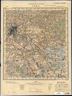
- Description:
- 1933
- Subject:
- Topical Subject: Maps, Topical Subject: Soviet Union, and Geographic Subject: Minsk
- Publisher:
- Генеральный штаб Красной Армии
- Language:
- Russian
- Date Created:
- 1938
- Identifier:
- VAC9619-004080
- Genre:
- Military Maps and Topographic Maps
- Geographic Location:
- Coordinates: 53.667, 27.5, 54, 28
- Related URL:
- Catalog URL: https://iucat.iu.edu/catalog/5020129 and Download GeoTIFF: https://drive.google.com/file/d/1YVJLOpfn04m2mPNRRdppW9VRjMR7iLjc/view?usp=sharing
- Abstract:
- Modern area represented: Minsk, Belarus
- Call Number:
- G7000 s100 .S7 sheet N-35-80
- Caption:
- Не подлежит оглашению
- City:
- Минск (Minsk)
- Copyright Holder:
- No Copyright - United States
- Country:
- СССР (USSR)
- State/Province:
- Белорусская ССР (Byelorussian Soviet Socialist Republic) and Минская область (Minsk oblast)
- Physical Description:
- Scale: 1:100,000
- Persistent URL:
- http://purl.dlib.indiana.edu/iudl/images/VAC9619/VAC9619-004080
- Provenance:
- Geographic Names Branch
-
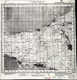
- Description:
- 1935
- Subject:
- Topical Subject: Maps, Geographic Subject: Yeyskoye Ukrepleniye, and Topical Subject: Soviet Union
- Publisher:
- Генеральный штаб Красной Армии
- Language:
- Russian
- Date Created:
- 1938
- Identifier:
- VAC9619-002293
- Genre:
- Topographic Maps and Military Maps
- Geographic Location:
- Coordinates: 46.6667, 38.5, 47, 39
- Related URL:
- Catalog URL: https://iucat.iu.edu/catalog/5020129 and Download GeoTIFF: https://drive.google.com/file/d/1l8Y0gwYEf2tBKWG4raDsZHtB57IQK3rB/view?usp=sharing
- Abstract:
- Modern area represented: Yeyskoye Ukrepleniye, Krasnodar kray, Russia
- Call Number:
- G7000 s100 .S7 sheet L-37-42
- Caption:
- Для служебного пользования
- City:
- Ейское Укрепление (Yeyskoye Ukrepleniye)
- Copyright Holder:
- No Copyright - United States
- Country:
- СССР (USSR)
- State/Province:
- Краснодарский край (Krasnodar kray), РСФСР (RSFSR), and Ростовская область (Rostov oblast)
- Physical Description:
- Scale: 1:100,000
- Persistent URL:
- http://purl.dlib.indiana.edu/iudl/images/VAC9619/VAC9619-002293
- Provenance:
- CIA Map Library
-

- Description:
- 1923
- Subject:
- Topical Subject: Soviet Union, Topical Subject: Maps, and Geographic Subject: Kaniv
- Publisher:
- Генеральный штаб Красной Армии
- Language:
- Russian
- Date Created:
- 1938
- Identifier:
- VAC9619-003298
- Genre:
- Topographic Maps and Military Maps
- Geographic Location:
- Coordinates: 49.667, 31, 50, 31.5
- Related URL:
- Catalog URL: https://iucat.iu.edu/catalog/5020129 and Download GeoTIFF: https://drive.google.com/file/d/18uFdqJKy1Up9JM9AnfY5uG9_XJZ7gI2l/view?usp=sharing
- Abstract:
- Modern area represented: Kaniv, Cherkasy oblast, Ukraine
- Call Number:
- G7000 s100 .S7 sheet M-36-75
- Caption:
- Для служебного пользования
- City:
- Канев (Kaniv)
- Copyright Holder:
- No Copyright - United States
- Country:
- СССР (USSR)
- State/Province:
- Украинская ССР (Ukrainian Soviet Socialist Republic) and Киевская область (Kyiv oblast)
- Physical Description:
- Scale: 1:100,000
- Persistent URL:
- http://purl.dlib.indiana.edu/iudl/images/VAC9619/VAC9619-003298
- Provenance:
- DMA Topographic Center, Army Map Service Library, OMAHA, Library of Congress Geography & Map Division
-
- Description:
- 1903
- Subject:
- Topical Subject: Soviet Union, Topical Subject: Maps, and Geographic Subject: Hantsavichy
- Publisher:
- Генеральный штаб Красной Армии
- Language:
- Russian
- Date Created:
- 1938
- Identifier:
- VAC9619-004117
- Genre:
- Topographic Maps and Military Maps
- Geographic Location:
- Coordinates: 52.667, 26, 53, 26.5
- Related URL:
- Download GeoTIFF: https://drive.google.com/file/d/15tK3o5PIrWM_k3EumLzrSPC-XVorngzB/view?usp=sharing and Catalog URL: https://iucat.iu.edu/catalog/5020129
- Abstract:
- Modern area represented: Hantsavichy, Brest oblast, Belarus
- Call Number:
- G7000 s100 .S7 sheet N-35-113
- City:
- Ганцевиче (Hantsavichy)
- Copyright Holder:
- No Copyright - United States
- Country:
- СССР (USSR)
- State/Province:
- Белорусская ССР (Byelorussian Soviet Socialist Republic), Барановичская область (Baranavichy oblast), and Пинская область (Pinsk oblast)
- Physical Description:
- Scale: 1:100,000
- Persistent URL:
- http://purl.dlib.indiana.edu/iudl/images/VAC9619/VAC9619-004117
- Provenance:
- DMA Topographic Center, OMAHA, Geographic Names Branch, Army Map Service Library
-
- Description:
- 1910
- Subject:
- Topical Subject: Soviet Union, Topical Subject: Maps, and Geographic Subject: Sernyky
- Publisher:
- Генеральный штаб Красной Армии
- Language:
- Russian
- Date Created:
- 1938
- Identifier:
- VAC9619-003046
- Genre:
- Military Maps and Topographic Maps
- Geographic Location:
- Coordinates: 51.667, 26, 52, 26.5
- Related URL:
- Catalog URL: https://iucat.iu.edu/catalog/5020129 and Download GeoTIFF: https://drive.google.com/file/d/1H9UQ5jmL2sxn7oKF5G4mXmAdfHP5hUmz/view?usp=sharing
- Abstract:
- Modern area represented: Sernyky, Rivne oblast, Ukraine
- Call Number:
- G7000 s100 .S7 sheet M-35-5
- City:
- Серники (Sernyky)
- Copyright Holder:
- No Copyright - United States
- Country:
- СССР (USSR)
- State/Province:
- Пинская область (Pinsk oblast), Белорусская ССР (Byelorussian Soviet Socialist Republic), Ровенская область (Rivne oblast), and Украинская ССР (Ukrainian Sov...
- Physical Description:
- Scale: 1:100,000
- Persistent URL:
- http://purl.dlib.indiana.edu/iudl/images/VAC9619/VAC9619-003046
- Provenance:
- DMA Topographic Center, Army Map Service Library, OMAHA, Library of Congress Geography & Map Division
-
- Description:
- 1936
- Subject:
- Topical Subject: Soviet Union, Geographic Subject: Vitebsk, and Topical Subject: Maps
- Publisher:
- Генеральный штаб Красной Армии
- Language:
- Russian
- Date Created:
- 1938
- Identifier:
- VAC9619-004164
- Genre:
- Topographic Maps and Military Maps
- Geographic Location:
- Coordinates: 55, 30, 55.333, 30.5
- Related URL:
- Download GeoTIFF: https://drive.google.com/file/d/17jTFV6nSSo5JfPA_QwdnfFodsl_Dxfjo/view?usp=sharing and Catalog URL: https://iucat.iu.edu/catalog/5020129
- Abstract:
- Modern area represented: Vitebsk, Vitebsk oblast, Belarus
- Call Number:
- G7000 s100 .S7 sheet N-36-25
- City:
- Витебск (Vitebsk)
- Copyright Holder:
- No Copyright - United States
- Country:
- СССР (USSR)
- State/Province:
- Витебская область (Vitebsk oblast) and Белорусская ССР (Byelorussian Soviet Socialist Republic)
- Physical Description:
- Scale: 1:100,000
- Persistent URL:
- http://purl.dlib.indiana.edu/iudl/images/VAC9619/VAC9619-004164
- Provenance:
- DMA Topographic Center, Auswärtiges Amt. Geographischer Dienst, OMAHA, Army Map Service Library
-

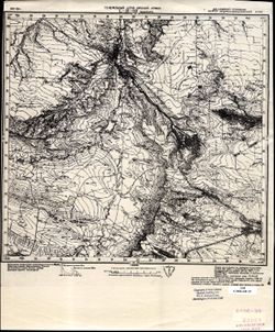
- Description:
- 1931
- Subject:
- Topical Subject: Soviet Union, Topical Subject: Maps, Geographic Subject: Stavropol' Krai, and Geographic Subject: Temnolesskaya
- Publisher:
- Генеральный штаб Красной Армии
- Language:
- Russian
- Date Created:
- 1938
- Identifier:
- VAC9619-002197
- Genre:
- Military Maps and Topographic Maps
- Geographic Location:
- Coordinates: 44.6667, 42, 45, 42.5
- Related URL:
- Download GeoTIFF: https://drive.google.com/open?id=12GKDLC24aDpcdVy38uDunyZQMCy4W3D6 and Catalog URL: https://iucat.iu.edu/catalog/5020129
- Abstract:
- Modern area represented: Темнолесская (Temnolesskaya), Stavropol' Krai, Russia
- Call Number:
- G7000 s100 .S7 sheet L-38-109
- Caption:
- Для cлужебного пользования
- City:
- Темнолесская (Temnolesskaya)
- Copyright Holder:
- No Copyright - United States
- Country:
- СССР (USSR)
- State/Province:
- Орджоникидзевский край (Ordzhonikidze kray) and РСФСР (RSFSR)
- Physical Description:
- Scale: 1:100,000
- Persistent URL:
- http://purl.dlib.indiana.edu/iudl/images/VAC9619/VAC9619-002197
- Provenance:
- CIA Map Library, Army Map Service Library
-
- Description:
- 1915
- Subject:
- Topical Subject: Maps, Topical Subject: Soviet Union, and Geographic Subject: Dovhe
- Publisher:
- Генеральный штаб Красной Армии
- Language:
- Russian
- Date Created:
- 1938
- Identifier:
- VAC9619-003038
- Genre:
- Military Maps and Topographic Maps
- Geographic Location:
- Coordinates: 48.333, 23, 48.667, 23.5
- Related URL:
- Catalog URL: https://iucat.iu.edu/catalog/5020129 and Download GeoTIFF: https://drive.google.com/file/d/1Vah3w10ssNOu-oswhVk2lEej6k1722u8/view?usp=sharing
- Abstract:
- Modern area represented: Dovhe, Zakarpattia oblast, Ukraine
- Call Number:
- G7000 s100 .S7 sheet M-34-131
- City:
- Довге (Dovhe)
- Copyright Holder:
- No Copyright - United States
- Country:
- Карпатская Украина (Carpatho-Ukraine) and Венгрия (Hungary)
- Physical Description:
- Scale: 1:100,000
- Persistent URL:
- http://purl.dlib.indiana.edu/iudl/images/VAC9619/VAC9619-003038
- Provenance:
- DMA Topographic Center, Army Map Service Library, OMAHA, Library of Congress Geography & Map Division
-
- Subject:
- Topical Subject: Soviet Union, Geographic Subject: Pechory, and Topical Subject: Maps
- Publisher:
- Генеральный штаб Красной Армии
- Language:
- Russian
- Date Created:
- 1938
- Identifier:
- VAC9619-002106
- Genre:
- Military Maps and Topographic Maps
- Geographic Location:
- Coordinates: 57.6667, 27.5, 58, 28
- Related URL:
- Download GeoTIFF: https://drive.google.com/open?id=1oIqhyRgN76rVz7lkr0YHiRaa1FZEEWTJ and Catalog URL: https://iucat.iu.edu/catalog/5020129
- Abstract:
- Modern area represented: Печоры (Pechory), Pskovskaya oblast, Russia
- Call Number:
- G7000 s100 .S7 sheet O-35-80
- Caption:
- Для служебного пользования
- City:
- Петсери (Petseri)
- Copyright Holder:
- No Copyright - United States
- Country:
- СССР (USSR) and Эстония (Estonia)
- State/Province:
- Ленинградская область (Leningrad oblast) and РСФСР (RSFSR)
- Physical Description:
- Scale: 1:100,000
- Persistent URL:
- http://purl.dlib.indiana.edu/iudl/images/VAC9619/VAC9619-002106
- Provenance:
- DMA Topographic Center, Army Map Service Library, OMAHA, Library of Congress Geography & Map Division
