
Search Constraints
You searched for:
Campus
IUB
Remove constraint Campus: IUB
Date Created
1940
Remove constraint Date Created: 1940
Holding Location
B-WELLS
Remove constraint Holding Location: B-WELLS
Type
Image
Remove constraint Type: Image
Pages
0-99 pages
Remove constraint Pages: 0-99 pages
« Previous |
1 - 50 of 458
|
Next »
Search Results
-
![Clark County [Indiana] land use map](https://iiif.uits.iu.edu/iiif/2/0p097b31w%2Ffiles%2F05b32dea-49f5-4006-84cd-ba5a5f21b5fb/full/250,/0/default.jpg)
- Subject:
- Geographic Subject: Clark County (Ind.) and Topical Subject: Land use
- Creator:
- Clark County (Ind.). Land Use Planning Committee
- Publisher:
- Clark County (Ind.). Land Use Planning Committee
- Date Created:
- 1940
- Identifier:
- VAC3073-M-00765
- Genre:
- Thematic maps
- Geographic Location:
- Coordinates: W0855940 W0852455 N0383624 N0381601
- Related URL:
- Catalog URL: https://iucat.iu.edu/catalog/5125787
- Abstract:
- Includes chart showing type of land use, acreage, and recommended use.
- Call Number:
- G4093.C4G4 1940 C53
- Caption:
- Imprint: [Jeffersonville, Ind.?] : The Committee, [1940?]
- Physical Description:
- Scale: Scale not given. and Dimensions: 26 x 19 cm, on sheet 39 x 28 cm
- Alternate Identifier:
- Title Control Number: a5125787
- Persistent URL:
- https://purl.dlib.indiana.edu/iudl/images/VAC3073/VAC3073-M-00765
-
![Crawford County [Indiana] land use map: preliminary](https://iiif.uits.iu.edu/iiif/2/4x51jm535%2Ffiles%2Fa4e48692-d643-428b-b306-48b4149d9cca/full/250,/0/default.jpg)
- Subject:
- Topical Subject: Land use and Geographic Subject: Crawford County (Ind.)
- Creator:
- Crawford County (Ind.). Land Use Planning Committee
- Publisher:
- Crawford County (Ind.). Land Use Planning Committee
- Date Created:
- 1940
- Identifier:
- VAC3073-M-00755
- Genre:
- Thematic maps
- Geographic Location:
- Coordinates: W0864053 W0861443 N0382522 N0380619
- Related URL:
- Catalog URL: https://iucat.iu.edu/catalog/5125845
- Abstract:
- Includes chart showing type of land use, acreage, and recommended use.
- Call Number:
- G4093.C7G4 1940 .C73
- Caption:
- Imprint: [English, Ind,?] : The Committee, [1940?]
- Physical Description:
- Dimensions: 24 x 25 cm, on sheet 28 x 39 cm and Scale: Scale not given.
- Alternate Identifier:
- Title Control Number: a5125845
- Persistent URL:
- https://purl.dlib.indiana.edu/iudl/images/VAC3073/VAC3073-M-00755
-
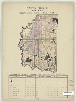
- Subject:
- Geographic Subject: Daviess County (Ind.) and Topical Subject: Land use
- Creator:
- Daviess County (Ind.). Land Use Planning Committee
- Publisher:
- United States. Bureau of Agricultural Economics
- Date Created:
- 1940
- Identifier:
- VAC3073-M-00818
- Genre:
- Thematic maps
- Geographic Location:
- Coordinates: W0871645 W0865414 N0385415 N0382925
- Related URL:
- Catalog URL: https://iucat.iu.edu/catalog/5125899
- Abstract:
- "Color reproduction by Bureau of Agricultural Economics, U.S.D.A." Includes chart showing type of land use, acreage, and recommended use.
- Call Number:
- G4093 .D2G4 1940 .D38
- Caption:
- Imprint: [Washington, D.C.?] : U.S. Bureau of Agricultural Economics, [1940]
- Physical Description:
- Scale: Scale not given. and Dimensions: 23 x 16 cm, on sheet 38 x 28 cm
- Alternate Identifier:
- Title Control Number: a5125899
- Persistent URL:
- https://purl.dlib.indiana.edu/iudl/images/VAC3073/VAC3073-M-00818
-
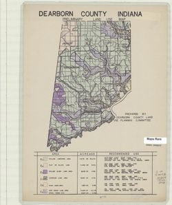
- Subject:
- Geographic Subject: Dearborn County (Ind.) and Topical Subject: Land use
- Creator:
- Dearborn County (Ind.). Land Use Planning Committee
- Publisher:
- Dearborn County (Ind.). Land Use Planning Committee
- Date Created:
- 1940
- Identifier:
- VAC3073-M-00613
- Genre:
- Thematic maps
- Geographic Location:
- Coordinates: W0850757 W0844909 N0391826 N0385607
- Related URL:
- Catalog URL: https://iucat.iu.edu/catalog/5126249
- Abstract:
- Includes chart showing type of land use, acreage, and recommended use.
- Call Number:
- G4093.D3G4 1940 .D43
- Caption:
- Imprint: [Lawrenceburg, Ind.?] : The Committee, [1940?]
- Physical Description:
- Dimensions: 26 x 17 cm, on sheet 39 x 28 cm and Scale: Scale not given.
- Alternate Identifier:
- Title Control Number: a5126249
- Persistent URL:
- https://purl.dlib.indiana.edu/iudl/images/VAC3073/VAC3073-M-00613
-
![Dubois County [Indiana] land use map : preliminary](https://iiif.uits.iu.edu/iiif/2/n583zx450%2Ffiles%2F8319c249-85b5-442f-8ac2-cef230e85e51/full/250,/0/default.jpg)
- Subject:
- Topical Subject: Land use and Geographic Subject: Dubois County (Ind.)
- Creator:
- Dubois County (Ind.). Land Use Planning Committee
- Publisher:
- Dubois County (Ind.). Land Use Planning Committee
- Date Created:
- 1940
- Identifier:
- VAC3073-M-00356
- Genre:
- Thematic maps
- Geographic Location:
- Coordinates: W0870423 W0864044 N0383135 N0381210
- Related URL:
- Catalog URL: https://iucat.iu.edu/catalog/5126254
- Abstract:
- Includes chart showing type of land use, acreage, and recommended use.
- Call Number:
- G4093.D8G4 1940 D83
- Caption:
- Imprint: [Jasper, Ind.?] : The Committee, [1940?]
- Physical Description:
- Dimensions: 22 x 22 cm, on sheet 39 x 28 cm and Scale: Scale not given.
- Alternate Identifier:
- Title Control Number: a5126254
- Persistent URL:
- https://purl.dlib.indiana.edu/iudl/images/VAC3073/VAC3073-M-00356
-
![Fayette County [Indiana] preliminary land use map](https://iiif.uits.iu.edu/iiif/2/xk81kq192%2Ffiles%2F166701bf-144d-4037-bd2c-0e915f8f7b76/full/250,/0/default.jpg)
- Subject:
- Geographic Subject: Fayette County (Ind.) and Topical Subject: Land use
- Creator:
- Fayette County (Ind.). Land Use Planning Committee
- Publisher:
- Fayette County (Ind.). Land Use Planning Committee
- Date Created:
- 1940
- Identifier:
- VAC3073-M-00246
- Genre:
- Thematic maps
- Geographic Location:
- Coordinates: W0851805 W0850204 N0394718 N0393131
- Related URL:
- Catalog URL: https://iucat.iu.edu/catalog/5126278
- Abstract:
- Includes chart showing type of land use, acreage, and recommended use.
- Call Number:
- G4093.F3G4 1940 .F39
- Caption:
- Imprint: [Connersville, Ind.?] : The Committee, [1940?]
- Physical Description:
- Dimensions: 19 x 16 cm, on sheet 39 x 28 cm and Scale: Scale not given.
- Alternate Identifier:
- Title Control Number: a5126278
- Persistent URL:
- https://purl.dlib.indiana.edu/iudl/images/VAC3073/VAC3073-M-00246
-
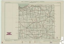
- Subject:
- Geographic Subject: Indiana and Topical Subject: Roads
- Creator:
- United States. Public Roads Administration
- Publisher:
- United States. Public Roads Administration
- Date Created:
- 1940
- Identifier:
- VAC3073-M-00588
- Genre:
- Road maps
- Geographic Location:
- Coordinates: W0880700 W0844500 N0414500 N0375200
- Related URL:
- Catalog URL: https://iucat.iu.edu/catalog/5164306
- Abstract:
- "Base map from U.S. Geological Survey state map." "Data corrected to May 1, 1940."
- Call Number:
- G4091.P2 1940 .U5
- Caption:
- Imprint: [Washington, D.C.?] : The Administration, [1940]
- Physical Description:
- Scale: 1:500,000 and Dimensions: 92 x 70 cm, sheets 55 x 79 cm
- Alternate Identifier:
- Title Control Number: a5164306
- Persistent URL:
- https://purl.dlib.indiana.edu/iudl/images/VAC3073/VAC3073-M-00588
-
![Floyd County [Indiana] land use map : preliminary](https://iiif.uits.iu.edu/iiif/2/r207vr80n%2Ffiles%2Fba1ce671-118c-499c-8c40-0c3612b65e19/full/250,/0/default.jpg)
- Subject:
- Geographic Subject: Floyd County (Ind.) and Topical Subject: Land use
- Creator:
- Floyd County (Ind.). Land Use Planning Committee
- Publisher:
- Floyd County (Ind.). Land Use Planning Committee
- Date Created:
- 1940
- Identifier:
- VAC3073-M-00110
- Genre:
- Thematic maps
- Geographic Location:
- Coordinates: W0860159 W0854537 N0382508 N0381047
- Related URL:
- Catalog URL: https://iucat.iu.edu/catalog/5126281
- Abstract:
- Includes chart showing type of land use, acreage, and recommended use.
- Call Number:
- G4093.F5G4 1940 .F56
- Caption:
- Imprint: [New Albany, Ind.?] : The Committee, [1940?]
- Physical Description:
- Scale: Scale not given. and Dimensions: 18 x 17 cm, on sheet 39 x 28 cm
- Alternate Identifier:
- Title Control Number: a5126281
- Persistent URL:
- https://purl.dlib.indiana.edu/iudl/images/VAC3073/VAC3073-M-00110
-
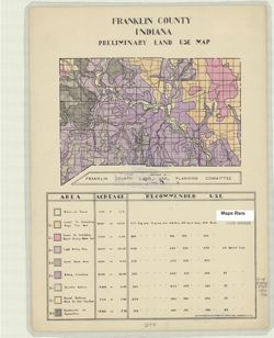
- Subject:
- Topical Subject: Land use and Geographic Subject: Franklin County (Ind.)
- Creator:
- Franklin County (Ind.). Land Use Planning Committee
- Publisher:
- United States. Bureau of Agricultural Economics
- Date Created:
- 1940
- Identifier:
- VAC3073-M-00144
- Genre:
- Thematic maps
- Geographic Location:
- Coordinates: W0851755 W0844855 N0393136 N0391605
- Related URL:
- Catalog URL: https://iucat.iu.edu/catalog/5126284
- Abstract:
- "Color reproduction by Bureau of Agricultural Economics, U.S.D.A." Includes chart showing type of land use, acreage, and recommended use.
- Call Number:
- G4093.F7G4 1940 .F73
- Caption:
- Imprint: [Washington, D.C.?] : U.S. Bureau of Agricultural Economics, [1940?]
- Physical Description:
- Dimensions: 15 x 21 cm, on sheet 38 x 28 cm and Scale: Scale not given.
- Alternate Identifier:
- Title Control Number: a5126284
- Persistent URL:
- https://purl.dlib.indiana.edu/iudl/images/VAC3073/VAC3073-M-00144
-
![Harrison County [Indiana] land use map : preliminary](https://iiif.uits.iu.edu/iiif/2/fb495d293%2Ffiles%2Fa6215f59-e4a8-4559-b192-18779587518f/full/250,/0/default.jpg)
- Subject:
- Topical Subject: Land use and Geographic Subject: Harrison County (Ind.)
- Creator:
- Harrison County (Ind.). Land Use Planning Committee
- Publisher:
- Harrison County (Ind.). Land Use Planning Committee
- Date Created:
- 1940
- Identifier:
- VAC3073-M-00901
- Genre:
- Thematic maps
- Geographic Location:
- Coordinates: W0861947 W0855402 N0382521 N0375728
- Related URL:
- Catalog URL: https://iucat.iu.edu/catalog/5126325
- Abstract:
- Includes chart showing type of land use, acreage, and recommended use.
- Call Number:
- G4093.H4G4 1940 .H37
- Caption:
- Imprint: [Corydon, Ind.?] : The Committee, [1940?]
- Physical Description:
- Scale: Scale not given. and Dimensions: 28 x 21 cm, on sheet 39 x 28 cm
- Alternate Identifier:
- Title Control Number: a5126325
- Persistent URL:
- https://purl.dlib.indiana.edu/iudl/images/VAC3073/VAC3073-M-00901
-
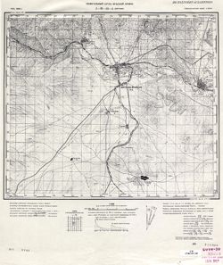
![Indiana Porter quadrangle [1940 printing]](https://iiif.uits.iu.edu/iiif/2/qb98nk032%2Ffiles%2F56b05fe7-af3d-4253-a42a-a53971fe7601/full/250,/0/default.jpg)
- Subject:
- Geographic Subject: Porter County (Ind.) and Geographic Subject: Lake County (Ind.)
- Creator:
- Clement, S. E. (Stephen Earl), 1894-1981 and Geological Survey (U.S.)
- Publisher:
- Geological Survey (U.S.)
- Date Created:
- 1940
- Identifier:
- VAC3073-M-01299
- Genre:
- 15 minute topographic maps, Quadrangle maps, and Topographic maps
- Geographic Location:
- Coordinates: W0871500 W0870000 N0414500 N0413000
- Related URL:
- Catalog URL: https://iucat.iu.edu/catalog/18416370
- Abstract:
- Filing title: Porter, Ind. Edition of 1940. Polyconic projection. Relief shown by contours and spot heights. Contour interval 10 feet. Surveyed in 1934. Repr...
- Call Number:
- G4090 s62 .G4 Porter 1940
- Caption:
- Imprint: Washington, D.C. : U.S. Dept. of the Interior, Geological Survey, 1940
- Physical Description:
- Scale: 1:62,500 and Dimensions: 45 x 42 cm or smaller
- Alternate Identifier:
- Title Control Number: a18416370
- Persistent URL:
- https://purl.dlib.indiana.edu/iudl/images/VAC3073/VAC3073-M-01299
- Provenance:
- Part of Geological Survey (U.S.). Indiana 1:62,500.
-
![Indiana Porter quadrangle [1940 printing]](https://iiif.uits.iu.edu/iiif/2/000013119%2Ffiles%2F0b2153bf-bc62-414d-8775-578073b39f68/full/250,/0/default.jpg)
- Subject:
- Geographic Subject: Lake County (Ind.) and Geographic Subject: Porter County (Ind.)
- Creator:
- Geological Survey (U.S.) and Clement, S. E. (Stephen Earl), 1894-1981
- Publisher:
- Geological Survey (U.S.)
- Date Created:
- 1940
- Identifier:
- VAC3073-M-01379
- Genre:
- Topographic maps, Quadrangle maps, and 15 minute topographic maps
- Geographic Location:
- Coordinates: W0871500 W0870000 N0414500 N0413000
- Related URL:
- Catalog URL: https://iucat.iu.edu/catalog/18416370
- Abstract:
- Filing title: Porter, Ind. Edition of 1940. Polyconic projection. Relief shown by contours and spot heights. Contour interval 10 feet. Surveyed in 1934. Repr...
- Call Number:
- G4090 s62 .G4 Porter 1940
- Caption:
- Imprint: Washington, D.C. : U.S. Dept. of the Interior, Geological Survey, 1940
- Physical Description:
- Scale: 1:62,500 and Dimensions: 45 x 42 cm or smaller
- Alternate Identifier:
- Title Control Number: a18416370
- Persistent URL:
- https://purl.dlib.indiana.edu/iudl/images/VAC3073/VAC3073-M-01379
- Provenance:
- Part of Geological Survey (U.S.). Indiana 1:62,500.
-
- Description:
- 1939
- Subject:
- Topical Subject: Maps, Geographic Subject: Naxçıvan, and Topical Subject: Soviet Union
- Publisher:
- Генеральный штаб РККА
- Language:
- Russian
- Date Created:
- 1940
- Identifier:
- VAC9619-000075
- Genre:
- Topographic Maps and Military Maps
- Geographic Location:
- Coordinates: 39.1667, 45.25, 39.3333, 45.5
- Related URL:
- Download GeoTIFF: https://drive.google.com/open?id=1WFbUP-xCIugjZ6sjO9PseZPZVj0V0Bno and Catalog URL: http://iucat.iu.edu/catalog/5020131
- Abstract:
- Modern area represented: Naxçıvan, Azerbaijan
- Call Number:
- G7000 s50 .S68 sheet J-38-31-B
- Caption:
- Не подлежит оглашению
- City:
- Нахичевань (Nakhichevan')
- Copyright Holder:
- No Copyright - United States
- Country:
- СССР (USSR) and Иран (Iran)
- State/Province:
- Нахичеванская АССР (Nakhichevan Autonomous Soviet Socialist Republic)
- Physical Description:
- Scale: 1:50,000
- Persistent URL:
- http://purl.dlib.indiana.edu/iudl/images/VAC9619/VAC9619-000075
- Provenance:
- CIA Map Library
-
- Subject:
- Geographic Subject: Nehrəm, Topical Subject: Maps, and Topical Subject: Soviet Union
- Publisher:
- Генеральный штаб РККА
- Language:
- Russian
- Date Created:
- 1940
- Identifier:
- VAC9619-000076
- Genre:
- Military Maps and Topographic Maps
- Geographic Location:
- Coordinates: 39, 45.25, 39.1667, 45.5
- Related URL:
- Download GeoTIFF: https://drive.google.com/open?id=1mM1VIpCbqqPPt0FAbm9talybksIlvehj and Catalog URL: http://iucat.iu.edu/catalog/5020131
- Abstract:
- Modern area represented: Nehrəm, Azerbaijan
- Call Number:
- G7000 s50 .S68 sheet J-38-31-D
- Caption:
- Не подлежит оглашению
- City:
- Неграм (Negram)
- Copyright Holder:
- No Copyright - United States
- Country:
- Иран (Iran) and СССР (USSR)
- State/Province:
- Нахичеванская АССР (Nakhichevan Autonomous Soviet Socialist Republic)
- Physical Description:
- Scale: 1:50,000
- Persistent URL:
- http://purl.dlib.indiana.edu/iudl/images/VAC9619/VAC9619-000076
- Provenance:
- CIA Map Library
-
- Description:
- 1939
- Subject:
- Geographic Subject: Əbrəqunus, Topical Subject: Soviet Union, and Topical Subject: Maps
- Publisher:
- Генеральный штаб РККА
- Language:
- Russian
- Date Created:
- 1940
- Identifier:
- VAC9619-000079
- Genre:
- Military Maps and Topographic Maps
- Geographic Location:
- Coordinates: 39, 45.5, 39.1667, 45.75
- Related URL:
- Download GeoTIFF: https://drive.google.com/open?id=1998swVPJ9QtnYo-IMWGIfroqvaOTFJb9 and Catalog URL: http://iucat.iu.edu/catalog/5020131
- Abstract:
- Modern area represented: Əbrəqunus, Azerbaijan
- Call Number:
- G7000 s50 .S68 sheet J-38-32-C
- Caption:
- Не подлежит оглашению
- City:
- Абракунис
- Copyright Holder:
- No Copyright - United States
- Country:
- СССР (USSR)
- State/Province:
- Нахичеванская АССР (Nakhichevan Autonomous Soviet Socialist Republic)
- Physical Description:
- Scale: 1:50,000
- Persistent URL:
- http://purl.dlib.indiana.edu/iudl/images/VAC9619/VAC9619-000079
- Provenance:
- CIA Map Library
-
- Description:
- 1912
- Subject:
- Topical Subject: Soviet Union and Topical Subject: Maps
- Publisher:
- Генеральный штаб РККА
- Language:
- Russian
- Date Created:
- 1940
- Identifier:
- VAC9619-000088
- Genre:
- Military Maps and Topographic Maps
- Geographic Location:
- Coordinates: 38.8333, 45.25, 39, 45.5
- Related URL:
- Catalog URL: http://iucat.iu.edu/catalog/5020131 and Download GeoTIFF: https://drive.google.com/open?id=1Oy-smGi4yZi1PkUg9SECDFKap9ehGyxn
- Call Number:
- G7000 s50 .S68 sheet J-38-39-B
- Caption:
- Не подлежит оглашению
- City:
- Гюльферадж (Gyulferadzh)
- Copyright Holder:
- No Copyright - United States
- Country:
- СССР (USSR) and Иран (Iran)
- State/Province:
- Нахичеванская АССР (Nakhichevan Autonomous Soviet Socialist Republic)
- Physical Description:
- Scale: 1:50,000
- Persistent URL:
- http://purl.dlib.indiana.edu/iudl/images/VAC9619/VAC9619-000088
-
- Subject:
- Topical Subject: Maps, Topical Subject: Soviet Union, and Geographic Subject: Julfa
- Publisher:
- Генеральный штаб Красной Армии
- Language:
- Russian
- Date Created:
- 1940
- Identifier:
- VAC9619-000089
- Genre:
- Topographic Maps and Military Maps
- Geographic Location:
- Coordinates: 38.8333, 45.5, 39, 45.75
- Related URL:
- Download GeoTIFF: https://drive.google.com/open?id=1fZhMoeilfY5E-PsoYnAeUMHJQW6GUmXx and Catalog URL: http://iucat.iu.edu/catalog/5020131
- Abstract:
- Modern area represented: Julfa, Azerbaijan
- Call Number:
- G7000 s50 .S68 sheet J-38-44-A
- Caption:
- Не подлежит оглашению
- City:
- Джульфа (Dzhulfa)
- Copyright Holder:
- No Copyright - United States
- Country:
- Иран (Iran) and СССР (USSR)
- State/Province:
- Нахичеванская АССР (Nakhichevan Autonomous Soviet Socialist Republic)
- Physical Description:
- Scale: 1:50,000
- Persistent URL:
- http://purl.dlib.indiana.edu/iudl/images/VAC9619/VAC9619-000089
- Provenance:
- CIA Map Library
-
![Jefferson County [Indiana] preliminary land use map](https://iiif.uits.iu.edu/iiif/2/2f75sc94w%2Ffiles%2F7a98897d-f193-46e6-9bdf-a873b1f3fc06/full/250,/0/default.jpg)
- Subject:
- Geographic Subject: Jefferson County (Ind.) and Topical Subject: Land use
- Creator:
- Jefferson County (Ind.). Land Use Planning Committee
- Publisher:
- United States. Bureau of Agricultural Economics
- Date Created:
- 1940
- Identifier:
- VAC3073-M-00300
- Genre:
- Thematic maps
- Geographic Location:
- Coordinates: W0854102 W0851205 N0385450 N0383509
- Related URL:
- Catalog URL: https://iucat.iu.edu/catalog/5126351
- Abstract:
- "Color reproduction by Bureau of Agricultural Economics, U.S.D.A." Includes chart showing type of land use, acreage, and recommended use.
- Call Number:
- G4093.J5 G4 1940 .J44
- Caption:
- Imprint: [Washington, D.C.?] : U.S. Bureau of Agricultural Economics, [1940?]
- Physical Description:
- Dimensions: 19 x 22 cm, on sheet 38 x 28 cm and Scale: Scale not given.
- Alternate Identifier:
- Title Control Number: a5126351
- Persistent URL:
- https://purl.dlib.indiana.edu/iudl/images/VAC3073/VAC3073-M-00300
-

- Description:
- 1906
- Subject:
- Topical Subject: Maps and Topical Subject: Soviet Union
- Publisher:
- Генеральный штаб РККА
- Language:
- Russian
- Date Created:
- 1940
- Identifier:
- VAC9619-000854
- Genre:
- Military Maps and Topographic Maps
- Related URL:
- Catalog URL: https://iucat.iu.edu/catalog/5020129
- Call Number:
- G7000 s100 .S7 sheet K-52-31
- City:
- Ст. Чатяогоу
- Copyright Holder:
- No Copyright - United States
- Physical Description:
- Scale: 1:100,000
- Persistent URL:
- http://purl.dlib.indiana.edu/iudl/images/VAC9619/VAC9619-000854
- Provenance:
- DMA Topographic Center, Army Map Service Library, Library of Congress Geography & Map Division, Atlasblatt
-
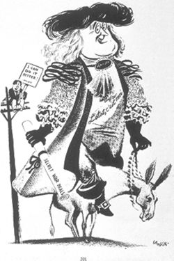
- Date Created:
- 1940
- Abstract:
- "L'Etat, C'est Moi," reprinted from The American Presidency in Political Cartoons: 1776-1976, p. 201.
- Call Number:
- 39B-1067107
- Alternate Identifier:
- 1067107
- Persistent URL:
- http://purl.dlib.indiana.edu/iudl/images/VAD5457/VAD5457-1067107
-

- Description:
- 1900
- Subject:
- Topical Subject: Maps, Geographic Subject: Deva, and Topical Subject: Soviet Union
- Publisher:
- Генеральный штаб Красной Армии
- Language:
- Russian
- Date Created:
- 1940
- Identifier:
- VAC9619-001255
- Genre:
- Topographic Maps and Military Maps
- Geographic Location:
- Coordinates: 45.6667, 22.5, 46, 23
- Related URL:
- Download GeoTIFF: https://drive.google.com/open?id=15eZ-SSDrKDZRKb7EoGa8LOVMH1kY1aG8 and Catalog URL: https://iucat.iu.edu/catalog/5020129
- Abstract:
- Modern area represented: Deva, Hunedoara county, Romania
- Call Number:
- G7000 s100 .S7 sheet L-34-82
- City:
- Дева (Deva)
- Copyright Holder:
- No Copyright - United States
- Country:
- Румыния (Romania)
- Physical Description:
- Scale: 1:100,000
- Persistent URL:
- http://purl.dlib.indiana.edu/iudl/images/VAC9619/VAC9619-001255
- Provenance:
- DMA Topographic Center, Army Map Service Library, Library of Congress Geography & Map Division
-
- Description:
- 1900
- Subject:
- Geographic Subject: Piteşti, Topical Subject: Soviet Union, and Topical Subject: Maps
- Publisher:
- Генеральный штаб РККА
- Language:
- Russian
- Date Created:
- 1940
- Identifier:
- VAC9619-001691
- Genre:
- Military Maps and Topographic Maps
- Geographic Location:
- Coordinates: 44.6667, 24.5, 45, 25
- Related URL:
- Catalog URL: https://iucat.iu.edu/catalog/5020129 and Download GeoTIFF: https://drive.google.com/open?id=1p0QpTmFIG_U0Hb_evN49aBe5qjLuUXm5
- Abstract:
- Modern area represented: Piteşti, Argeş county, Romania
- Call Number:
- G7000 s100 .S7 sheet L-35-110
- City:
- Питешти (Piteşti)
- Copyright Holder:
- No Copyright - United States
- Country:
- Румыния (Romania)
- Physical Description:
- Scale: 1:100,000
- Persistent URL:
- http://purl.dlib.indiana.edu/iudl/images/VAC9619/VAC9619-001691
- Provenance:
- DMA Topographic Center, Army Map Service Library, Library of Congress Geography & Map Division, Atlasblatt
-

- Description:
- 1896
- Subject:
- Topical Subject: Soviet Union, Topical Subject: Maps, and Geographic Subject: Târgovişte
- Publisher:
- Генеральный штаб РККА
- Language:
- Russian
- Date Created:
- 1940
- Identifier:
- VAC9619-001699
- Genre:
- Military Maps and Topographic Maps
- Geographic Location:
- Coordinates: 44.6667, 25, 45, 25.5
- Related URL:
- Catalog URL: https://iucat.iu.edu/catalog/5020129 and Download GeoTIFF: https://drive.google.com/open?id=1gMse-lAECHRdjGB57_UtvfIaN-GdoIs9
- Abstract:
- Modern area represented: Târgovişte, Dâmboviţa county, Romania
- Call Number:
- G7000 s100 .S7 sheet L-35-111
- City:
- Тырговиште (Târgovişte)
- Copyright Holder:
- No Copyright - United States
- Country:
- Румыния (Romania)
- Physical Description:
- Scale: 1:100,000
- Persistent URL:
- http://purl.dlib.indiana.edu/iudl/images/VAC9619/VAC9619-001699
- Provenance:
- DMA Topographic Center, Army Map Service Library, OMAHA, Atlasblatt, Library of Congress Geography & Map Division
-
- Description:
- 1891
- Subject:
- Topical Subject: Soviet Union, Topical Subject: Maps, and Geographic Subject: Ploieşti
- Publisher:
- Генеральный штаб Красной Армии
- Language:
- Russian
- Date Created:
- 1940
- Identifier:
- VAC9619-001710
- Genre:
- Military Maps and Topographic Maps
- Geographic Location:
- Coordinates: 44.6667, 26, 45, 26.5
- Related URL:
- Catalog URL: https://iucat.iu.edu/catalog/5020129 and Download GeoTIFF: https://drive.google.com/open?id=1kbO5Fn1_gAfzsDWVCBnsh83RvgIf2cLC
- Abstract:
- Modern area represented: Ploieşti, Prahova county, Romania
- Call Number:
- G7000 s100 .S7 sheet L-35-113
- City:
- Плоешти (Ploieşti)
- Copyright Holder:
- No Copyright - United States
- Country:
- Румыния (Romania)
- Physical Description:
- Scale: 1:100,000
- Persistent URL:
- http://purl.dlib.indiana.edu/iudl/images/VAC9619/VAC9619-001710
- Provenance:
- DMA Topographic Center, Army Map Service Library, Library of Congress Geography & Map Division
-
- Description:
- 1894
- Subject:
- Topical Subject: Maps, Geographic Subject: Tătaru, and Topical Subject: Soviet Union
- Publisher:
- Генеральный штаб Красной Армии
- Language:
- Russian
- Date Created:
- 1940
- Identifier:
- VAC9619-001756
- Genre:
- Military Maps and Topographic Maps
- Geographic Location:
- Coordinates: 44.6667, 27, 45, 27.5
- Related URL:
- Catalog URL: https://iucat.iu.edu/catalog/5020129 and Download GeoTIFF: https://drive.google.com/open?id=12-p_BHuRv8fuQGL5nfUTZsaVfPTWOkwj
- Abstract:
- Modern area represented: Tătaru, Brăila county, Romania
- Call Number:
- G7000 s100 .S7 sheet L-35-115
- City:
- Татару (Tătaru)
- Copyright Holder:
- No Copyright - United States
- Country:
- Румыния (Romania)
- Physical Description:
- Scale: 1:100,000
- Persistent URL:
- http://purl.dlib.indiana.edu/iudl/images/VAC9619/VAC9619-001756
- Provenance:
- DMA Topographic Center, Army Map Service Library, Library of Congress Geography & Map Division
-
- Description:
- 1891
- Subject:
- Topical Subject: Soviet Union, Topical Subject: Maps, and Geographic Subject: Bucharest
- Publisher:
- Генеральный штаб Красной Армии
- Language:
- Russian
- Date Created:
- 1940
- Identifier:
- VAC9619-001794
- Genre:
- Military Maps and Topographic Maps
- Geographic Location:
- Coordinates: 44.3333, 26, 44.6667, 26.5
- Related URL:
- Catalog URL: https://iucat.iu.edu/catalog/5020129 and Download GeoTIFF: https://drive.google.com/open?id=1Qp3MYlVquPkot6GrpfLeHpxTWY4p62PS
- Abstract:
- Modern area represented: Bucharest, Bucureşti county, Romania
- Call Number:
- G7000 s100 .S7 sheet L-35-125
- City:
- Бухарест (Bucharest)
- Copyright Holder:
- No Copyright - United States
- Country:
- Румыния (Romania)
- Physical Description:
- Scale: 1:100,000
- Persistent URL:
- http://purl.dlib.indiana.edu/iudl/images/VAC9619/VAC9619-001794
- Provenance:
- DMA Topographic Center, Army Map Service Library, OMAHA, Library of Congress Geography & Map Division
-
- Description:
- 1905
- Subject:
- Topical Subject: Soviet Union, Topical Subject: Maps, and Geographic Subject: Roșiorii de Vede
- Publisher:
- Генеральный штаб РККА
- Language:
- Russian
- Date Created:
- 1940
- Identifier:
- VAC9619-001805
- Genre:
- Topographic Maps and Military Maps
- Geographic Location:
- Coordinates: 44, 24.5, 44.3333, 25
- Related URL:
- Catalog URL: https://iucat.iu.edu/catalog/5020129 and Download GeoTIFF: https://drive.google.com/open?id=1FL58q-DJnIMTpAZZgJSsyZUt5SSzmh7X
- Abstract:
- Modern area represented: Roșiorii de Vede, Teleorman county, Romania
- Call Number:
- G7000 s100 .S7 sheet L-35-134
- City:
- Рошиори - Де Веде (Roșiorii de Vede)
- Copyright Holder:
- No Copyright - United States
- Country:
- Румыния (Romania)
- Physical Description:
- Scale: 1:100,000
- Persistent URL:
- http://purl.dlib.indiana.edu/iudl/images/VAC9619/VAC9619-001805
- Provenance:
- DMA Topographic Center, Army Map Service Library, Library of Congress Geography & Map Division
-
- Description:
- 1883
- Subject:
- Topical Subject: Maps, Geographic Subject: Drăgăneşti-Vlaşca, and Topical Subject: Soviet Union
- Publisher:
- Генеральный штаб Красной Армии
- Language:
- Russian
- Date Created:
- 1940
- Identifier:
- VAC9619-001808
- Genre:
- Topographic Maps and Military Maps
- Geographic Location:
- Coordinates: 44, 25.5, 44.3333, 26
- Related URL:
- Download GeoTIFF: https://drive.google.com/open?id=1kk3WO5ndJeaX7rwmkETltz7GczrbyMJb and Catalog URL: https://iucat.iu.edu/catalog/5020129
- Abstract:
- Modern area represented: Drăgăneşti-Vlaşca, Giurgiu county, Romania
- Call Number:
- G7000 s100 .S7 sheet L-35-136
- City:
- Дрэгэнешти (Drăgăneşti)
- Copyright Holder:
- No Copyright - United States
- Country:
- Румыния (Romania)
- Physical Description:
- Scale: 1:100,000
- Persistent URL:
- http://purl.dlib.indiana.edu/iudl/images/VAC9619/VAC9619-001808
- Provenance:
- DMA Topographic Center, Army Map Service Library, Library of Congress Geography & Map Division
-
- Description:
- 1893
- Subject:
- Topical Subject: Maps, Topical Subject: Soviet Union, and Geographic Subject: Budeşti
- Publisher:
- Генеральный штаб Красной Армии
- Language:
- Russian
- Date Created:
- 1940
- Identifier:
- VAC9619-001809
- Genre:
- Military Maps and Topographic Maps
- Geographic Location:
- Coordinates: 44, 26, 44.3333, 26.5
- Related URL:
- Catalog URL: https://iucat.iu.edu/catalog/5020129 and Download GeoTIFF: https://drive.google.com/open?id=1tDXhb1hBuYrOkSbvJmeKh7J1IEkm384b
- Abstract:
- Modern area represented: Budeşti, Giurgiu county, Romania
- Call Number:
- G7000 s100 .S7 sheet L-35-137
- City:
- Будешти (Budeşti)
- Copyright Holder:
- No Copyright - United States
- Country:
- Румыния (Romania) and Болгария (Bulgaria)
- Physical Description:
- Scale: 1:100,000
- Persistent URL:
- http://purl.dlib.indiana.edu/iudl/images/VAC9619/VAC9619-001809
- Provenance:
- DMA Topographic Center, Army Map Service Library, Library of Congress Geography & Map Division
-
- Description:
- 1873
- Subject:
- Topical Subject: Soviet Union, Topical Subject: Maps, and Geographic Subject: Călărasi-Targ
- Publisher:
- Генеральный штаб РККА
- Language:
- Russian
- Date Created:
- 1940
- Identifier:
- VAC9619-001529
- Genre:
- Topographic Maps and Military Maps
- Geographic Location:
- Coordinates: 47, 28, 47.3333, 28.5
- Related URL:
- Download GeoTIFF: https://drive.google.com/open?id=1tChuAu9yqWs5ys8Z7tNhOEmgq69Apb3I and Catalog URL: https://iucat.iu.edu/catalog/5020129
- Abstract:
- Modern area represented: Călărasi-Targ, Călăraşi county, Moldova
- Call Number:
- G7000 s100 .S7 sheet L-35-33
- City:
- Калараш-Тырг (Călărasi-Targ)
- Copyright Holder:
- No Copyright - United States
- Country:
- Румыния (Romania)
- State/Province:
- Бессарабия (Bessarabia)
- Physical Description:
- Scale: 1:100,000
- Persistent URL:
- http://purl.dlib.indiana.edu/iudl/images/VAC9619/VAC9619-001529
- Provenance:
- CIA Map Library
-
- Description:
- 1888
- Subject:
- Topical Subject: Maps, Geographic Subject: Roman, and Topical Subject: Soviet Union
- Publisher:
- Генеральный штаб РККА
- Language:
- Russian
- Date Created:
- 1940
- Identifier:
- VAC9619-001540
- Genre:
- Military Maps and Topographic Maps
- Geographic Location:
- Coordinates: 46.6667, 26.5, 47, 27
- Related URL:
- Download GeoTIFF: https://drive.google.com/open?id=1i2pvbe1wRYaxyTOVF2cgHePtUEz_ZnoF and Catalog URL: https://iucat.iu.edu/catalog/5020129
- Abstract:
- Modern area represented: Roman, Neamţ county, Romania
- Call Number:
- G7000 s100 .S7 sheet L-35-42
- City:
- Роман (Roman)
- Copyright Holder:
- No Copyright - United States
- Country:
- Румыния (Romania)
- Physical Description:
- Scale: 1:100,000
- Persistent URL:
- http://purl.dlib.indiana.edu/iudl/images/VAC9619/VAC9619-001540
- Provenance:
- CIA Map Library
-
- Description:
- 1875
- Subject:
- Topical Subject: Maps, Topical Subject: Soviet Union, and Geographic Subject: Tighina
- Publisher:
- Генеральный штаб РККА
- Language:
- Russian
- Date Created:
- 1940
- Identifier:
- VAC9619-001549
- Genre:
- Military Maps and Topographic Maps
- Geographic Location:
- Coordinates: 46.6667, 29, 47, 29.5
- Related URL:
- Catalog URL: https://iucat.iu.edu/catalog/5020129 and Download GeoTIFF: https://drive.google.com/open?id=1MZ4PrCBw5im-5F634wMbg7bDcKcTTsDN
- Abstract:
- Modern area represented: Tighina, Bender municipality, Moldova
- Call Number:
- G7000 s100 .S7 sheet L-35-47
- Caption:
- Не подлежит оглашению
- City:
- Бендеры (Bendery)
- Copyright Holder:
- No Copyright - United States
- State/Province:
- Бессарабия (Bessarabia), Украинская ССР (Ukrainian Soviet Socialist Republic), and Молдавская АССР (Moldavian Autonomous Soviet Socialist Republic)
- Physical Description:
- Scale: 1:100,000
- Persistent URL:
- http://purl.dlib.indiana.edu/iudl/images/VAC9619/VAC9619-001549
- Provenance:
- CIA Map Library, Geographisches Institut der Universität Berlin
-
- Description:
- 1891
- Subject:
- Topical Subject: Soviet Union, Topical Subject: Maps, and Geographic Subject: Dragomireşti
- Publisher:
- Генеральный штаб Красной Армии
- Language:
- Russian
- Date Created:
- 1940
- Identifier:
- VAC9619-001755
- Genre:
- Military Maps and Topographic Maps
- Geographic Location:
- Coordinates: 46.3333, 27, 46.6667, 27.5
- Related URL:
- Download GeoTIFF: https://drive.google.com/file/d/1hCPO_hgwRlOoKYWPQdYYSitq_p-y_Ezx/view?usp=sharing and Catalog URL: https://iucat.iu.edu/catalog/5020129
- Abstract:
- Modern area represented: Dragomireşti, Vaslui county, Romania
- Call Number:
- G7000 s100 .S7 sheet L-35-55
- City:
- Драгомирешти (Dragomireşti)
- Copyright Holder:
- No Copyright - United States
- Country:
- Румыния (Romania)
- Physical Description:
- Scale: 1:100,000
- Persistent URL:
- http://purl.dlib.indiana.edu/iudl/images/VAC9619/VAC9619-001755
- Provenance:
- CIA Map Library
-
- Description:
- 1875
- Subject:
- Topical Subject: Soviet Union, Geographic Subject: Leova, and Topical Subject: Maps
- Publisher:
- Генеральный штаб РККА
- Language:
- Russian
- Date Created:
- 1940
- Identifier:
- VAC9619-001576
- Genre:
- Military Maps and Topographic Maps
- Geographic Location:
- Coordinates: 46.3333, 28, 46.6667, 28.5
- Related URL:
- Catalog URL: https://iucat.iu.edu/catalog/5020129 and Download GeoTIFF: https://drive.google.com/open?id=1W71to7iMT8UwC4o77msQuVXKGW3_2Y6g
- Abstract:
- Modern area represented: Leova, Leova district, Moldova
- Call Number:
- G7000 s100 .S7 sheet L-35-57
- City:
- Леово (Leovo)
- Copyright Holder:
- No Copyright - United States
- Country:
- Румыния (Romania)
- State/Province:
- Бессарабия (Bessarabia)
- Physical Description:
- Scale: 1:100,000
- Persistent URL:
- http://purl.dlib.indiana.edu/iudl/images/VAC9619/VAC9619-001576
- Provenance:
- CIA Map Library, Atlasblatt
-
- Description:
- 1875
- Subject:
- Geographic Subject: Volintiri, Topical Subject: Soviet Union, and Topical Subject: Maps
- Publisher:
- Генеральный штаб РККА
- Language:
- Russian
- Date Created:
- 1940
- Identifier:
- VAC9619-001581
- Genre:
- Topographic Maps and Military Maps
- Geographic Location:
- Coordinates: 46.3333, 29.5, 46.6667, 30
- Related URL:
- Download GeoTIFF: https://drive.google.com/open?id=1yjBpyWEhLGUL0b_IOaIHHjcBR0P7r7Hi and Catalog URL: https://iucat.iu.edu/catalog/5020129
- Abstract:
- Modern area represented: Volintiri, Ștefan Vodă district, Moldova
- Call Number:
- G7000 s100 .S7 sheet L-35-60
- Caption:
- Не подлежит оглашению
- City:
- Волинтирь (Volintiri)
- Copyright Holder:
- No Copyright - United States
- Country:
- СССР (USSR)
- State/Province:
- Украинская ССР (Ukrainian Soviet Socialist Republic), Одесская область (Odessa oblast), Молдавская АССР (Moldavian Autonomous Soviet Socialist Republic), and...
- Physical Description:
- Scale: 1:100,000
- Persistent URL:
- http://purl.dlib.indiana.edu/iudl/images/VAC9619/VAC9619-001581
- Provenance:
- Library of Congress Geography & Map Division, Atlasblatt, DMA Topographic Center, Army Map Service Library, OMAHA
-

- Description:
- 1889
- Subject:
- Geographic Subject: Sighișoara, Topical Subject: Soviet Union, and Topical Subject: Maps
- Publisher:
- Генеральный штаб РККА
- Language:
- Russian
- Date Created:
- 1940
- Identifier:
- VAC9619-001572
- Genre:
- Topographic Maps and Military Maps
- Geographic Location:
- Coordinates: 46, 24.5, 46.3333, 25
- Related URL:
- Catalog URL: https://iucat.iu.edu/catalog/5020129 and Download GeoTIFF: https://drive.google.com/open?id=1pMjt1y7xJ_zezttERad19SLcAJyJ7ok-
- Abstract:
- Modern area represented: Sighișoara, Mureş county, Romania
- Call Number:
- G7000 s100 .S7 sheet L-35-62
- City:
- Сигишоара (Sighișoara)
- Copyright Holder:
- No Copyright - United States
- Country:
- Венгрия (Hungary) and Румыния (Romania)
- Physical Description:
- Scale: 1:100,000
- Persistent URL:
- http://purl.dlib.indiana.edu/iudl/images/VAC9619/VAC9619-001572
- Provenance:
- Library of Congress Geography & Map Division, Atlasblatt, DMA Topographic Center, Army Map Service Library, OMAHA
-
- Description:
- 1889
- Subject:
- Topical Subject: Soviet Union, Geographic Subject: Făgăraș, and Topical Subject: Maps
- Publisher:
- Генеральный штаб Красной Армии
- Language:
- Russian
- Date Created:
- 1940
- Identifier:
- VAC9619-001652
- Genre:
- Military Maps and Topographic Maps
- Geographic Location:
- Coordinates: 45.6667, 24.5, 46, 25
- Related URL:
- Catalog URL: https://iucat.iu.edu/catalog/5020129 and Download GeoTIFF: https://drive.google.com/open?id=1r58aE53jzC1uEcMtXoMsOM5HyoZ_rRZJ
- Abstract:
- Modern area represented: Făgăraș, Brașov county, Romania
- Call Number:
- G7000 s100 .S7 sheet L-35-74
- City:
- Фэгэраш (Făgăraș)
- Copyright Holder:
- No Copyright - United States
- Country:
- Румыния (Romania)
- Physical Description:
- Scale: 1:100,000
- Persistent URL:
- http://purl.dlib.indiana.edu/iudl/images/VAC9619/VAC9619-001652
- Provenance:
- CIA Map Library, Atlasblatt, Library of Congress Geography & Map Division
-
- Description:
- 1889
- Subject:
- Topical Subject: Maps, Topical Subject: Soviet Union, and Geographic Subject: Şercaia
- Publisher:
- Генеральный штаб Красной Армии
- Language:
- Russian
- Date Created:
- 1940
- Identifier:
- VAC9619-001664
- Genre:
- Topographic Maps and Military Maps
- Geographic Location:
- Coordinates: 45.6667, 25, 46, 25.5
- Related URL:
- Download GeoTIFF: https://drive.google.com/open?id=15sEsGkhtdVQiriI3v_WnvLBxHlw8Fmf4 and Catalog URL: https://iucat.iu.edu/catalog/5020129
- Abstract:
- Modern area represented: Şercaia, Brașov county, Romania
- Call Number:
- G7000 s100 .S7 sheet L-35-75
- City:
- Шеркая (Şercaia)
- Copyright Holder:
- No Copyright - United States
- Country:
- Румыния (Romania)
- Physical Description:
- Scale: 1:100,000
- Persistent URL:
- http://purl.dlib.indiana.edu/iudl/images/VAC9619/VAC9619-001664
- Provenance:
- CIA Map Library, Library of Congress Geography & Map Division
-

- Description:
- 1900
- Subject:
- Topical Subject: Soviet Union, Topical Subject: Maps, and Geographic Subject: Curtea de Argeş
- Publisher:
- Генеральный штаб Красной Армии
- Language:
- Russian
- Date Created:
- 1940
- Identifier:
- VAC9619-001686
- Genre:
- Topographic Maps and Military Maps
- Geographic Location:
- Coordinates: 45, 24.5, 45.3333, 25
- Related URL:
- Catalog URL: https://iucat.iu.edu/catalog/5020129 and Download GeoTIFF: https://drive.google.com/open?id=1xKHUf8r5kzgNfr-nYXFiSmBdlkvyDwU8
- Abstract:
- Modern area represented: Curtea de Argeş, Argeș county, Romania
- Call Number:
- G7000 s100 .S7 sheet L-35-98
- City:
- Куртя де Арджеш (Curtea de Argeş)
- Copyright Holder:
- No Copyright - United States
- Country:
- Румыния (Romania)
- Physical Description:
- Scale: 1:100,000
- Persistent URL:
- http://purl.dlib.indiana.edu/iudl/images/VAC9619/VAC9619-001686
- Provenance:
- DMA Topographic Center, Army Map Service Library, OMAHA, Atlasblatt, Library of Congress Geography & Map Division
-
- Description:
- 1925
- Subject:
- Topical Subject: Maps, Geographic Subject: Mykolayivka, and Topical Subject: Soviet Union
- Publisher:
- Генеральный штаб Красной Армии
- Language:
- Russian
- Date Created:
- 1940
- Identifier:
- VAC9619-001822
- Genre:
- Topographic Maps and Military Maps
- Geographic Location:
- Coordinates: 47.6667, 34, 48, 34.5
- Related URL:
- Download GeoTIFF: https://drive.google.com/open?id=1U6J1cZ3jBto4nQW05mxJrvbDFQrg0G8o and Catalog URL: https://iucat.iu.edu/catalog/5020129
- Abstract:
- Modern area represented: Mykolayivka, Dnipropetrovsk oblast, Ukraine
- Call Number:
- G7000 s100 .S7 sheet L-36-9
- Caption:
- Для служебного пользования
- City:
- Ново-Николаевка (Novo-Nikolayevka)
- Copyright Holder:
- No Copyright - United States
- Country:
- СССР (USSR)
- State/Province:
- Украинская ССР (Ukrainian Soviet Socialist Republic) and Днепропетровская область (Dnipropetrovsk oblast)
- Physical Description:
- Scale: 1:100,000
- Persistent URL:
- http://purl.dlib.indiana.edu/iudl/images/VAC9619/VAC9619-001822
- Provenance:
- CIA Map Library, Atlasblatt
-
- Description:
- 1926
- Subject:
- Geographic Subject: Azov, Geographic Subject: Rostov oblast, Topical Subject: Soviet Union, and Topical Subject: Maps
- Publisher:
- Главное управление геодезии и картографии при СНК СССР
- Language:
- Russian
- Date Created:
- 1940
- Identifier:
- VAC9619-002285
- Genre:
- Topographic Maps and Military Maps
- Geographic Location:
- Coordinates: 47, 39, 47.3333, 39.5
- Related URL:
- Download GeoTIFF: https://drive.google.com/file/d/1ZVtvAnypf4ZFXI2NppFs0SerXf00lb1Z/view?usp=sharing and Catalog URL: https://iucat.iu.edu/catalog/5020129
- Abstract:
- Modern area represented: Azov, Russia
- Call Number:
- G7000 s100 .S7 sheet L-37-31
- Caption:
- Для служебного пользования
- City:
- Азов (Azov)
- Copyright Holder:
- No Copyright - United States
- Country:
- СССР (USSR)
- State/Province:
- Ростовская область (Rostov oblast) and РСФСР (RSFSR)
- Physical Description:
- Scale: 1:100,000
- Persistent URL:
- http://purl.dlib.indiana.edu/iudl/images/VAC9619/VAC9619-002285
- Provenance:
- Geographic Names Branch, Heeresplankammer 1. Abt. (Pl. A.) Auslandskartenarchiv
-
- Description:
- 1893
- Subject:
- Topical Subject: Maps, Topical Subject: Soviet Union, Geographic Subject: Kuibyshivs'kyi district, and Geographic Subject: Donetsk
- Publisher:
- Генеральный штаб Красной Армии
- Language:
- Russian
- Date Created:
- 1940
- Identifier:
- VAC9619-001990
- Genre:
- Topographic Maps and Military Maps
- Geographic Location:
- Coordinates: 47.6667, 37.5, 48, 38
- Related URL:
- Catalog URL: https://iucat.iu.edu/catalog/5020129 and Download GeoTIFF: https://drive.google.com/open?id=1A-5kl08Fmj97FOj3_cwBOc3JNpHC0Hcd
- Abstract:
- Modern area represented: Куйбышевский район (Kuibyshivs'kyi district), Donetsk, Ukraine
- Call Number:
- G7000 s100 .S7 sheet L-37-4
- Caption:
- Для cлужебного пользования
- City:
- Сталино (Stalino)
- Copyright Holder:
- No Copyright - United States
- Country:
- СССР (USSR)
- State/Province:
- Украинская ССР (Ukrainian Soviet Socialist Republic) and Сталинская область (Stalino oblast)
- Physical Description:
- Scale: 1:100,000
- Persistent URL:
- http://purl.dlib.indiana.edu/iudl/images/VAC9619/VAC9619-001990
- Provenance:
- DMA Topographic Center
-
- Description:
- 1935
- Subject:
- Geographic Subject: Aleksandrovka, Topical Subject: Maps, and Topical Subject: Soviet Union
- Publisher:
- Главное управление геодезии и картографии при СНК СССР
- Language:
- Russian
- Date Created:
- 1940
- Identifier:
- VAC9619-002294
- Genre:
- Military Maps and Topographic Maps
- Geographic Location:
- Coordinates: 46.6667, 39, 47, 39.5
- Related URL:
- Catalog URL: https://iucat.iu.edu/catalog/5020129 and Download GeoTIFF: https://drive.google.com/file/d/12RMoPzLmycgdNa_ZeRr0BYWXrRKFao9C/view?usp=sharing
- Abstract:
- Modern area represented: Aleksandrovka, Krasnodar kray, Russia
- Call Number:
- G7000 s100 .S7 sheet L-37-43
- Caption:
- Для служебного пользования
- City:
- Александровка (Aleksandrovka)
- Copyright Holder:
- No Copyright - United States
- Country:
- СССР (USSR)
- State/Province:
- Краснодарский край (Krasnodar kray), Ростовская область (Rostov oblast), and РСФСР (RSFSR)
- Physical Description:
- Scale: 1:100,000
- Persistent URL:
- http://purl.dlib.indiana.edu/iudl/images/VAC9619/VAC9619-002294
- Provenance:
- DMA Topographic Center, Army Map Service Library, OMAHA, Library of Congress Geography & Map Division
-
- Description:
- 1935
- Subject:
- Topical Subject: Maps, Topical Subject: Soviet Union, and Geographic Subject: Kamyshevatskaya
- Publisher:
- Главное управление геодезии и картографии при СНК СССР
- Language:
- Russian
- Date Created:
- 1940
- Identifier:
- VAC9619-002469
- Genre:
- Topographic Maps and Military Maps
- Geographic Location:
- Coordinates: 46.333, 37.5, 46.667, 38
- Related URL:
- Catalog URL: https://iucat.iu.edu/catalog/5020129 and Download GeoTIFF: https://drive.google.com/file/d/1FZNP0AszmtgO2r8VCGGm5F4L25pPyivc/view?usp=sharing
- Abstract:
- Modern area represented: Kamyshevatskaya, Russia
- Call Number:
- G7000 s100 .S7 sheet L-37-52
- Caption:
- Для служебного пользования
- City:
- Станница Камышеватская (Kamyshevatskaya)
- Copyright Holder:
- No Copyright - United States
- Country:
- СССР (USSR)
- State/Province:
- Краснодарский край (Krasnodar kray) and РСФСР (RSFSR)
- Physical Description:
- Scale: 1:100,000
- Persistent URL:
- http://purl.dlib.indiana.edu/iudl/images/VAC9619/VAC9619-002469
- Provenance:
- DMA Topographic Center, Library of Congress G & M Division, OMAHA, Army Map Service Library
-
- Description:
- 1935
- Subject:
- Topical Subject: Soviet Union, Geographic Subject: Yasenskaya, and Topical Subject: Maps
- Publisher:
- Генеральный штаб Красной Армии
- Language:
- Russian
- Date Created:
- 1940
- Identifier:
- VAC9619-002320
- Genre:
- Military Maps and Topographic Maps
- Geographic Location:
- Coordinates: 46.3333, 38, 46.6667, 38.5
- Related URL:
- Catalog URL: https://iucat.iu.edu/catalog/5020129 and Download GeoTIFF: https://drive.google.com/file/d/1ANfBQuPlscLZ3TLWYKArV4_UX4oV-Ab6/view?usp=sharing
- Abstract:
- Modern area represented: Yasenskaya, Russia
- Call Number:
- G7000 s100 .S7 sheet L-37-53
- Caption:
- Для служебного пользования
- City:
- Ст-ца Ясенская (Yasenskaya)
- Copyright Holder:
- No Copyright - United States
- Country:
- СССР (USSR)
- State/Province:
- РСФСР (RSFSR) and Краснодарский край (Krasnodar kray)
- Physical Description:
- Scale: 1:100,000
- Persistent URL:
- http://purl.dlib.indiana.edu/iudl/images/VAC9619/VAC9619-002320
- Provenance:
- DMA Topographic Center, Army Map Service Library
-
- Description:
- 1935
- Subject:
- Topical Subject: Soviet Union, Topical Subject: Maps, and Geographic Subject: Staroshcherbinovskaya
- Publisher:
- Генеральный штаб Красной Армии
- Language:
- Russian
- Date Created:
- 1940
- Identifier:
- VAC9619-002321
- Genre:
- Military Maps and Topographic Maps
- Geographic Location:
- Coordinates: 46.3333, 38.5, 46.6667, 39
- Related URL:
- Catalog URL: https://iucat.iu.edu/catalog/5020129 and Download GeoTIFF: https://drive.google.com/file/d/1ra_mJa5O-R4zF0rl3TtNkSQRl0GDEvcn/view?usp=sharing
- Abstract:
- Modern area represented: Staroshcherbinovskaya, Russia
- Call Number:
- G7000 s100 .S7 sheet L-37-54
- Caption:
- Для служебного пользования
- City:
- Ст-ца Старо-Щербиновская (Staro-Shcherbinovskaya)
- Copyright Holder:
- No Copyright - United States
- Country:
- СССР (USSR)
- State/Province:
- РСФСР (RSFSR), Краснодарский край (Krasnodar kray), and Ростовская область (Rostov oblast)
- Physical Description:
- Scale: 1:100,000
- Persistent URL:
- http://purl.dlib.indiana.edu/iudl/images/VAC9619/VAC9619-002321
- Provenance:
- DMA Topographic Center, Army Map Service Library
-
- Description:
- 1936
- Subject:
- Topical Subject: Soviet Union, Geographic Subject: Rogovskaya, and Topical Subject: Maps
- Publisher:
- Главное управление геодезии и картографии при СНК СССР
- Language:
- Russian
- Date Created:
- 1940
- Identifier:
- VAC9619-002338
- Genre:
- Topographic Maps and Military Maps
- Geographic Location:
- Coordinates: 45.667, 38.5, 46, 39
- Related URL:
- Download GeoTIFF: https://drive.google.com/file/d/1Z_my8K4ECfFywgELXq5ypJAneao9d9kI/view?usp=sharing and Catalog URL: https://iucat.iu.edu/catalog/5020129
- Abstract:
- Modern area represented: Rogovskaya, Russia
- Call Number:
- G7000 s100 .S7 sheet L-37-78
- Caption:
- Для служебного пользования
- City:
- Станица Роговская (Stanitsa Rogovskaya)
- Copyright Holder:
- No Copyright - United States
- Country:
- СССР (USSR)
- State/Province:
- РСФСР (RSFSR) and Краснодарский край (Krasnodar kray)
- Physical Description:
- Scale: 1:100,000
- Persistent URL:
- http://purl.dlib.indiana.edu/iudl/images/VAC9619/VAC9619-002338
- Provenance:
- Army Map Service Library
-
- Description:
- 1939
- Subject:
- Topical Subject: Soviet Union and Topical Subject: Maps
- Publisher:
- Наркомрыбпром Главрыбвод
- Language:
- Russian
- Date Created:
- 1940
- Identifier:
- VAC9619-002252
- Genre:
- Military Maps and Topographic Maps
- Geographic Location:
- Coordinates: 46.6667, 48, 47, 48.5
- Related URL:
- Catalog URL: https://iucat.iu.edu/catalog/5020129 and Download GeoTIFF: https://drive.google.com/file/d/1JEcZSvpfcZHSYq47tULdaaommNe3T6fT/view?usp=sharing
- Abstract:
- Modern area represented:
- Call Number:
- G7000 s100 .S7 sheet L-39-37
- Caption:
- Рабочий оттиск. Бесплатно. Временное издание. Для внутреннего использования.
- City:
- Новая Урусовка (Novaya Urusovka)
- Copyright Holder:
- No Copyright - United States
- Country:
- СССР (USSR)
- State/Province:
- РСФСР (RSFSR) and Сталинградская область (Stalingrad oblast)
- Physical Description:
- Scale: 1:100,000
- Persistent URL:
- http://purl.dlib.indiana.edu/iudl/images/VAC9619/VAC9619-002252
- Provenance:
- DMA Topographic Center, Army Map Service Library
-
- Description:
- 1939
- Subject:
- Topical Subject: Soviet Union and Topical Subject: Maps
- Publisher:
- Наркомрыбпром Главрыбвод
- Language:
- Russian
- Date Created:
- 1940
- Identifier:
- VAC9619-002253
- Genre:
- Topographic Maps and Military Maps
- Geographic Location:
- Coordinates: 46.6667, 48.5, 47, 49
- Related URL:
- Download GeoTIFF: https://drive.google.com/file/d/12YwoFqwwXRltjU5q71pYY85QKDnbyHn9/view?usp=sharing and Catalog URL: https://iucat.iu.edu/catalog/5020129
- Abstract:
- Modern area represented:
- Call Number:
- G7000 s100 .S7 sheet L-39-38
- Copyright Holder:
- No Copyright - United States
- Country:
- СССР (USSR)
- State/Province:
- РСФСР (RSFSR), Сталинградская область (Stalingrad oblast), Гуриевская область (Guriev oblast), and Казахская ССР (Kazakh Soviet Socialist Republic)
- Physical Description:
- Scale: 1:100,000
- Persistent URL:
- http://purl.dlib.indiana.edu/iudl/images/VAC9619/VAC9619-002253
- Provenance:
- DMA Topographic Center, Army Map Service Library
-
- Description:
- 1939
- Subject:
- Topical Subject: Maps, Geographic Subject: Astrakhan, Topical Subject: Soviet Union, and Geographic Subject: Astrakhan Oblast’
- Publisher:
- Наркомрыбпром Главрыбвод
- Language:
- Russian
- Date Created:
- 1940
- Identifier:
- VAC9619-002254
- Genre:
- Topographic Maps and Military Maps
- Geographic Location:
- Coordinates: 46.3333, 48, 46.6667, 48.5
- Related URL:
- Catalog URL: https://iucat.iu.edu/catalog/5020129 and Download GeoTIFF: https://drive.google.com/file/d/1RCqPg_tDMJxKMYAkWR-P5U_oyqYZuJMF/view?usp=sharing
- Abstract:
- Modern area represented: Астрахань (Astrakhan), Astrakhan Oblast’, Russia
- Call Number:
- G7000 s100 .S7 sheet L-39-49
- City:
- Астрахань (Astrakhan)
- Copyright Holder:
- No Copyright - United States
- Country:
- СССР (USSR)
- State/Province:
- РСФСР (RSFSR), Калмыцкая АССР (Kalmyk Autonomous Soviet Socialist Republic), and Сталинградская область (Stalingrad oblast)
- Physical Description:
- Scale: 1:100,000
- Persistent URL:
- http://purl.dlib.indiana.edu/iudl/images/VAC9619/VAC9619-002254
- Provenance:
- DMA Topographic Center, Army Map Service Library
