
Search Constraints
You searched for:
Campus
IUB
Remove constraint Campus: IUB
Date Created
1940
Remove constraint Date Created: 1940
Type
Image
Remove constraint Type: Image
Pages
0-99 pages
Remove constraint Pages: 0-99 pages
Provenance
DMA Topographic Center, Army Map Service Library
Remove constraint Provenance: DMA Topographic Center, Army Map Service Library
« Previous |
1 - 20 of 64
|
Next »
Search Results
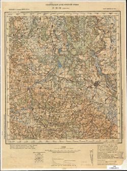
-

- Description:
- 1890
- Subject:
- Topical Subject: Soviet Union, Topical Subject: Maps, and Geographic Subject: Slonim
- Publisher:
- Генеральный штаб Красной Армии
- Language:
- Russian
- Date Created:
- 1940
- Identifier:
- VAC9619-004100
- Genre:
- Military Maps and Topographic Maps
- Geographic Location:
- Coordinates: 53, 25, 53.333, 25.5
- Related URL:
- Download GeoTIFF: https://drive.google.com/file/d/11uIlcuAi2jRjN2zbDtSfPdBrUot13QKy/view?usp=sharing and Catalog URL: https://iucat.iu.edu/catalog/5020129
- Abstract:
- Modern area represented: Slonim, Belarus
- Call Number:
- G7000 s100 .S7 sheet N-35-99
- City:
- Слоним (Slonim)
- Copyright Holder:
- No Copyright - United States
- Country:
- СССР (USSR)
- State/Province:
- Белорусская ССР (Byelorussian Soviet Socialist Republic) and Барановичская область (Baranavichy oblast)
- Physical Description:
- Scale: 1:100,000
- Persistent URL:
- http://purl.dlib.indiana.edu/iudl/images/VAC9619/VAC9619-004100
- Provenance:
- DMA Topographic Center, Army Map Service Library
-

- Description:
- 1892
- Subject:
- Topical Subject: Maps, Topical Subject: Soviet Union, and Geographic Subject: Masty
- Publisher:
- Генеральный штаб Красной Армии
- Language:
- Russian
- Date Created:
- 1940
- Identifier:
- VAC9619-004086
- Genre:
- Military Maps and Topographic Maps
- Geographic Location:
- Coordinates: 53.333, 24.5, 53.667, 25
- Related URL:
- Catalog URL: https://iucat.iu.edu/catalog/5020129 and Download GeoTIFF: https://drive.google.com/file/d/1oNc9X6dj_CufOGM3qycfol_3ZNvgto8i/view?usp=sharing
- Abstract:
- Modern area represented: Masty, Hrodno oblast, Belarus
- Call Number:
- G7000 s100 .S7 sheet N-35-86
- City:
- Мосты (Masty)
- Copyright Holder:
- No Copyright - United States
- Country:
- СССР (USSR)
- State/Province:
- Белорусская ССР (Byelorussian Soviet Socialist Republic), Барановичская область (Baranavichy oblast), and Белостокская область (Belastok oblast)
- Physical Description:
- Scale: 1:100,000
- Persistent URL:
- http://purl.dlib.indiana.edu/iudl/images/VAC9619/VAC9619-004086
- Provenance:
- DMA Topographic Center, Army Map Service Library
-
- Description:
- 1899
- Subject:
- Geographic Subject: Yuratsishki, Topical Subject: Soviet Union, and Topical Subject: Maps
- Publisher:
- Генеральный штаб Красной Армии
- Language:
- Russian
- Date Created:
- 1940
- Identifier:
- VAC9619-004065
- Genre:
- Topographic Maps and Military Maps
- Geographic Location:
- Coordinates: 54, 25.5, 54.333, 26
- Related URL:
- Download GeoTIFF: https://drive.google.com/file/d/1S208tYzBNgJlOJ0Z-RWb-phjImadfveI/view?usp=sharing and Catalog URL: https://iucat.iu.edu/catalog/5020129
- Abstract:
- Modern area represented: Yuratsishki, Hrodna oblast, Belarus
- Call Number:
- G7000 s100 .S7 sheet N-35-64
- Caption:
- Для служебного пользования
- City:
- Юратишки (Yuratsishki)
- Copyright Holder:
- No Copyright - United States
- Country:
- СССР (USSR)
- State/Province:
- Барановичская область (Baranavichy oblast), Вилейская область (Vileyka oblast), and Белорусская ССР (Byelorussian Soviet Socialist Republic)
- Physical Description:
- Scale: 1:100,000
- Persistent URL:
- http://purl.dlib.indiana.edu/iudl/images/VAC9619/VAC9619-004065
- Provenance:
- DMA Topographic Center, Army Map Service Library
-

- Description:
- 1890
- Subject:
- Topical Subject: Maps, Geographic Subject: Merkinė, and Topical Subject: Soviet Union
- Publisher:
- Генеральный штаб Красной Армии
- Language:
- Russian
- Date Created:
- 1940
- Identifier:
- VAC9619-004062
- Genre:
- Military Maps and Topographic Maps
- Geographic Location:
- Coordinates: 54, 24, 54.333, 24.5
- Related URL:
- Download GeoTIFF: https://drive.google.com/file/d/1y93Q-evfnuFOv1Y5G5Dz9TqcZre99-Eq/view?usp=sharing and Catalog URL: https://iucat.iu.edu/catalog/5020129
- Abstract:
- Modern area represented: Merkinė, Lithuania
- Call Number:
- G7000 s100 .S7 sheet N-35-61
- Caption:
- Для служебного пользования
- City:
- Меречь (Merecz)
- Copyright Holder:
- No Copyright - United States
- Country:
- СССР (USSR)
- State/Province:
- Литовская ССР (Lithuanian Soviet Socialist Republic)
- Physical Description:
- Scale: 1:100,000
- Persistent URL:
- http://purl.dlib.indiana.edu/iudl/images/VAC9619/VAC9619-004062
- Provenance:
- DMA Topographic Center, Army Map Service Library
-
- Description:
- 1904
- Subject:
- Geographic Subject: Vileyka, Topical Subject: Soviet Union, and Topical Subject: Maps
- Publisher:
- Генеральный штаб Красной Армии
- Language:
- Russian
- Date Created:
- 1940
- Identifier:
- VAC9619-004056
- Genre:
- Military Maps and Topographic Maps
- Geographic Location:
- Coordinates: 54.333, 26.5, 54.667, 27
- Related URL:
- Download GeoTIFF: https://drive.google.com/file/d/1kyEkVOJvt8AXa5spmn7Jfn3fOLgVscJy/view?usp=sharing and Catalog URL: https://iucat.iu.edu/catalog/5020129
- Abstract:
- Modern area represented: Vileyka, Belarus
- Call Number:
- G7000 s100 .S7 sheet N-35-54
- City:
- Вилейка (Vileyka)
- Copyright Holder:
- No Copyright - United States
- Country:
- СССР (USSR)
- State/Province:
- Вилейская область (Vileyka oblast) and Белорусская ССР (Byelorussian Soviet Socialist Republic)
- Physical Description:
- Scale: 1:100,000
- Persistent URL:
- http://purl.dlib.indiana.edu/iudl/images/VAC9619/VAC9619-004056
- Provenance:
- DMA Topographic Center, Army Map Service Library
-
- Description:
- 1903
- Subject:
- Geographic Subject: Smarhon, Topical Subject: Maps, and Topical Subject: Soviet Union
- Publisher:
- Генеральный штаб Красной Армии
- Language:
- Russian
- Date Created:
- 1940
- Identifier:
- VAC9619-004055
- Genre:
- Topographic Maps and Military Maps
- Geographic Location:
- Coordinates: 54.333, 26, 54.667, 26.5
- Related URL:
- Download GeoTIFF: https://drive.google.com/file/d/1Hyh1FTHPh2WfcSA6rFTZ67hecvz2-9cA/view?usp=sharing and Catalog URL: https://iucat.iu.edu/catalog/5020129
- Abstract:
- Modern area represented: Smarhon, Hrodna oblast, Belarus
- Call Number:
- G7000 s100 .S7 sheet N-35-53
- City:
- Сморгонь (Smarhon)
- Copyright Holder:
- No Copyright - United States
- Country:
- СССР (USSR)
- State/Province:
- Белорусская ССР (Byelorussian Soviet Socialist Republic) and Вилейская область (Vileyka oblast)
- Physical Description:
- Scale: 1:100,000
- Persistent URL:
- http://purl.dlib.indiana.edu/iudl/images/VAC9619/VAC9619-004055
- Provenance:
- DMA Topographic Center, Army Map Service Library
-
- Description:
- 1896
- Subject:
- Geographic Subject: Ashmyany, Topical Subject: Soviet Union, and Topical Subject: Maps
- Publisher:
- Генеральный штаб Красной Армии
- Language:
- Russian
- Date Created:
- 1940
- Identifier:
- VAC9619-004054
- Genre:
- Military Maps and Topographic Maps
- Geographic Location:
- Coordinates: 54.333, 25.5, 54.667, 26
- Related URL:
- Catalog URL: https://iucat.iu.edu/catalog/5020129 and Download GeoTIFF: https://drive.google.com/file/d/1VKQrpZUJwdq1ZfSwfhpiT5_kAXvkbyQM/view?usp=sharing
- Abstract:
- Modern area represented: Ashmyany, Hrodna oblast, Belarus
- Call Number:
- G7000 s100 .S7 sheet N-35-52
- City:
- Ошмяны (Ashmyany)
- Copyright Holder:
- No Copyright - United States
- Country:
- СССР (USSR)
- State/Province:
- Литовская ССР (Lithuanian Soviet Socialist Republic) and Белорусская ССР (Byelorussian Soviet Socialist Republic)
- Physical Description:
- Scale: 1:100,000
- Persistent URL:
- http://purl.dlib.indiana.edu/iudl/images/VAC9619/VAC9619-004054
- Provenance:
- DMA Topographic Center, Army Map Service Library
-

- Description:
- 1891
- Subject:
- Topical Subject: Soviet Union, Topical Subject: Maps, and Geographic Subject: Lentvaris
- Publisher:
- Генеральный штаб Красной Армии
- Language:
- Russian
- Date Created:
- 1940
- Identifier:
- VAC9619-004053
- Genre:
- Military Maps and Topographic Maps
- Geographic Location:
- Coordinates: 54.333, 25, 54.667, 25.5
- Related URL:
- Catalog URL: https://iucat.iu.edu/catalog/5020129 and Download GeoTIFF: https://drive.google.com/file/d/1pGDy3t6VgddIj8je6N5NWJd-o0jXgLYB/view?usp=sharing
- Abstract:
- Modern area represented: Lentvaris, Lithuania
- Call Number:
- G7000 s100 .S7 sheet N-35-51
- City:
- Ландворово (Landwarów)
- Copyright Holder:
- No Copyright - United States
- Country:
- СССР (USSR)
- State/Province:
- Белорусская ССР (Byelorussian Soviet Socialist Republic), Барановичская область (Baranavichy oblast), and Литовская ССР (Lithuanian Soviet Socialist Republic)
- Physical Description:
- Scale: 1:100,000
- Persistent URL:
- http://purl.dlib.indiana.edu/iudl/images/VAC9619/VAC9619-004053
- Provenance:
- DMA Topographic Center, Army Map Service Library
-
- Description:
- 1902
- Subject:
- Topical Subject: Maps, Topical Subject: Soviet Union, and Geographic Subject: Kanstantsinava
- Publisher:
- Генеральный штаб Красной Армии
- Language:
- Russian
- Date Created:
- 1940
- Identifier:
- VAC9619-004043
- Genre:
- Military Maps and Topographic Maps
- Geographic Location:
- Coordinates: 54.667, 26, 55, 26.5
- Related URL:
- Download GeoTIFF: https://drive.google.com/file/d/1fERWEWK0tAjQ0A3TwarxKhNxb2zUh5xs/view?usp=sharing and Catalog URL: https://iucat.iu.edu/catalog/5020129
- Abstract:
- Modern area represented: Kanstantsinava, Belarus
- Call Number:
- G7000 s100 .S7 sheet N-35-41
- Caption:
- Для служебного пользования
- City:
- Константинов (Konstantinov)
- Copyright Holder:
- No Copyright - United States
- Country:
- СССР (USSR)
- State/Province:
- Литовская ССР (Lithuanian Soviet Socialist Republic), Вилейская область (Vileyka oblast), and Белорусская ССР (Byelorussian Soviet Socialist Republic)
- Physical Description:
- Scale: 1:100,000
- Persistent URL:
- http://purl.dlib.indiana.edu/iudl/images/VAC9619/VAC9619-004043
- Provenance:
- DMA Topographic Center, Army Map Service Library
-
- Description:
- 1896
- Subject:
- Topical Subject: Soviet Union, Geographic Subject: Pabradė, and Topical Subject: Maps
- Publisher:
- Генеральный штаб Красной Армии
- Language:
- Russian
- Date Created:
- 1940
- Identifier:
- VAC9619-004042
- Genre:
- Military Maps and Topographic Maps
- Geographic Location:
- Coordinates: 54.667, 25.5, 55, 26
- Related URL:
- Catalog URL: https://iucat.iu.edu/catalog/5020129 and Download GeoTIFF: https://drive.google.com/file/d/1YFsfTU9po10RXE5Yt1qzruLaxNk6ivoW/view?usp=sharing
- Abstract:
- Modern area represented: Pabradė, Lithuania
- Call Number:
- G7000 s100 .S7 sheet N-35-40
- Caption:
- Для служебного пользования
- City:
- Подбродзе (Podbrodze)
- Copyright Holder:
- No Copyright - United States
- Country:
- СССР (USSR)
- State/Province:
- Белорусская ССР (Byelorussian Soviet Socialist Republic), Литовская ССР (Lithuanian Soviet Socialist Republic), and Вилейская область (Vileyka oblast)
- Physical Description:
- Scale: 1:100,000
- Persistent URL:
- http://purl.dlib.indiana.edu/iudl/images/VAC9619/VAC9619-004042
- Provenance:
- DMA Topographic Center, Army Map Service Library
-
- Description:
- 1933
- Subject:
- Geographic Subject: Kaišiadorys, Topical Subject: Maps, and Topical Subject: Soviet Union
- Publisher:
- Генеральный штаб Красной Армии
- Language:
- Russian
- Date Created:
- 1940
- Identifier:
- VAC9619-004039
- Genre:
- Military Maps and Topographic Maps
- Geographic Location:
- Coordinates: 54.667, 24, 55, 24.5
- Related URL:
- Download GeoTIFF: https://drive.google.com/file/d/1u7iA_SJyy7oFXOHofJMR2OXOAWl6U3oT/view?usp=sharing and Catalog URL: https://iucat.iu.edu/catalog/5020129
- Abstract:
- Modern area represented: Kaišiadorys, Kaunas, Lithuania
- Call Number:
- G7000 s100 .S7 sheet N-35-37
- Caption:
- Не подлежит оглашению
- City:
- Кошедары (Kashedary)
- Copyright Holder:
- No Copyright - United States
- Country:
- СССР (USSR)
- State/Province:
- Литовская ССР (Lithuanian Soviet Socialist Republic)
- Physical Description:
- Scale: 1:100,000
- Persistent URL:
- http://purl.dlib.indiana.edu/iudl/images/VAC9619/VAC9619-004039
- Provenance:
- DMA Topographic Center, Army Map Service Library
-
- Description:
- 1883
- Subject:
- Geographic Subject: Błonie, Topical Subject: Soviet Union, and Topical Subject: Maps
- Publisher:
- Генеральный штаб Красной Армии
- Language:
- Russian
- Date Created:
- 1940
- Identifier:
- VAC9619-003999
- Genre:
- Topographic Maps and Military Maps
- Geographic Location:
- Coordinates: 52, 20.5, 52.333, 21
- Related URL:
- Download GeoTIFF: https://drive.google.com/file/d/1Ka8pZd6P8aK1VYeCYu-ITjJaj12ruNSL/view?usp=sharing and Catalog URL: https://iucat.iu.edu/catalog/5020129
- Abstract:
- Modern area represented: Błonie, Masovian Voivodeship, Poland
- Call Number:
- G7000 s100 .S7 sheet N-34-138
- City:
- Блоне (Błonie)
- Copyright Holder:
- No Copyright - United States
- State/Province:
- Область государственных интересов Германии (Region of German state interests)
- Physical Description:
- Scale: 1:100,000
- Persistent URL:
- http://purl.dlib.indiana.edu/iudl/images/VAC9619/VAC9619-003999
- Provenance:
- DMA Topographic Center, Army Map Service Library
-

- Description:
- 1885
- Subject:
- Geographic Subject: Sochaczew, Topical Subject: Maps, and Topical Subject: Soviet Union
- Publisher:
- Генеральный штаб Красной Армии
- Language:
- Russian
- Date Created:
- 1940
- Identifier:
- VAC9619-003998
- Genre:
- Topographic Maps and Military Maps
- Geographic Location:
- Coordinates: 52, 20, 52.333, 20.5
- Related URL:
- Download GeoTIFF: https://drive.google.com/file/d/1sN0McnQZcS0wFqJrSIbV8XhVmgQK2SKA/view?usp=sharing and Catalog URL: https://iucat.iu.edu/catalog/5020129
- Abstract:
- Modern area represented: Sochaczew, Masovian Voivodeship, Poland
- Call Number:
- G7000 s100 .S7 sheet N-34-137
- City:
- Сохачев (Sochaczew)
- Copyright Holder:
- No Copyright - United States
- State/Province:
- Область государственных интересов Германии (Region of German state interests)
- Physical Description:
- Scale: 1:100,000
- Persistent URL:
- http://purl.dlib.indiana.edu/iudl/images/VAC9619/VAC9619-003998
- Provenance:
- DMA Topographic Center, Army Map Service Library
-
- Description:
- 1902
- Subject:
- Topical Subject: Soviet Union, Topical Subject: Maps, and Geographic Subject: Kutno
- Publisher:
- Генеральный штаб Красной Армии
- Language:
- Russian
- Date Created:
- 1940
- Identifier:
- VAC9619-003996
- Genre:
- Military Maps and Topographic Maps
- Geographic Location:
- Coordinates: 52, 19, 52.333, 19.5
- Related URL:
- Download GeoTIFF: https://drive.google.com/file/d/1jLBT7McZOV4EgCKD4TNViMFJBvUYoFEF/view?usp=sharing and Catalog URL: https://iucat.iu.edu/catalog/5020129
- Abstract:
- Modern area represented: Kutno, Łódź Voivodeship, Poland
- Call Number:
- G7000 s100 .S7 sheet N-34-135
- City:
- Кутно (Kutno)
- Copyright Holder:
- No Copyright - United States
- State/Province:
- Область государственных интересов Германии (Region of German state interests)
- Physical Description:
- Scale: 1:100,000
- Persistent URL:
- http://purl.dlib.indiana.edu/iudl/images/VAC9619/VAC9619-003996
- Provenance:
- DMA Topographic Center, Army Map Service Library
-
- Description:
- 1880
- Subject:
- Geographic Subject: Gmina Jadów, Topical Subject: Soviet Union, and Topical Subject: Maps
- Publisher:
- Генеральный штаб Красной Армии
- Language:
- Russian
- Date Created:
- 1940
- Identifier:
- VAC9619-003991
- Genre:
- Topographic Maps and Military Maps
- Geographic Location:
- Coordinates: 52.333, 21.5, 52.667, 22
- Related URL:
- Download GeoTIFF: https://drive.google.com/file/d/1mtSm9PaMfrTfFHwbr9CyBuoRcAWPtvuV/view?usp=sharing and Catalog URL: https://iucat.iu.edu/catalog/5020129
- Abstract:
- Modern area represented: Gmina Jadów, Masovian Voivodeship, Poland
- Call Number:
- G7000 s100 .S7 sheet N-34-128
- City:
- Ядув (Jadów)
- Copyright Holder:
- No Copyright - United States
- State/Province:
- Область государственных интересов Германии (Region of German state interests)
- Physical Description:
- Scale: 1:100,000
- Persistent URL:
- http://purl.dlib.indiana.edu/iudl/images/VAC9619/VAC9619-003991
- Provenance:
- DMA Topographic Center, Army Map Service Library
-
- Description:
- 1880
- Subject:
- Topical Subject: Soviet Union, Topical Subject: Maps, and Geographic Subject: Ostrow Mazowiecka
- Publisher:
- Генеральный штаб Красной Армии
- Language:
- Russian
- Date Created:
- 1940
- Identifier:
- VAC9619-003982
- Genre:
- Topographic Maps and Military Maps
- Geographic Location:
- Coordinates: 52.667, 21.5, 53, 22
- Related URL:
- Catalog URL: https://iucat.iu.edu/catalog/5020129 and Download GeoTIFF: https://drive.google.com/file/d/1HCGHGN4Ns_z7w6hyB17RSdg5Y_1WmW0a/view?usp=sharing
- Abstract:
- Modern area represented: Ostrow Mazowiecka, Masovian Voivodeship, Poland
- Call Number:
- G7000 s100 .S7 sheet N-34-116
- City:
- Острув-Мазовецки (Ostrow Mazowiecka)
- Copyright Holder:
- No Copyright - United States
- Country:
- СССР (USSR)
- State/Province:
- Область государственных интересов Германии (Region of German state interests), Белостокская область (Belastok oblast), and Белорусская ССР (Byelorussian Sovi...
- Physical Description:
- Scale: 1:100,000
- Persistent URL:
- http://purl.dlib.indiana.edu/iudl/images/VAC9619/VAC9619-003982
- Provenance:
- DMA Topographic Center, Army Map Service Library
-
- Description:
- 1883
- Subject:
- Geographic Subject: Pultusk, Topical Subject: Maps, and Topical Subject: Soviet Union
- Publisher:
- Генеральный штаб Красной Армии
- Language:
- Russian
- Date Created:
- 1940
- Identifier:
- VAC9619-003981
- Genre:
- Military Maps and Topographic Maps
- Geographic Location:
- Coordinates: 52.667, 21, 53, 21.5
- Related URL:
- Catalog URL: https://iucat.iu.edu/catalog/5020129 and Download GeoTIFF: https://drive.google.com/file/d/19LM1Y-p0SZOPHxfdVEu8byb4UdXlO2HU/view?usp=sharing
- Abstract:
- Modern area represented: Pultusk, Masovian Voivodship, Poland
- Call Number:
- G7000 s100 .S7 sheet N-34-115
- City:
- Пултуск (Pultusk)
- Copyright Holder:
- No Copyright - United States
- State/Province:
- Область государственных интересов Германии (Region of German state interests)
- Physical Description:
- Scale: 1:100,000
- Persistent URL:
- http://purl.dlib.indiana.edu/iudl/images/VAC9619/VAC9619-003981
- Provenance:
- DMA Topographic Center, Army Map Service Library
-
- Description:
- 1901
- Subject:
- Topical Subject: Soviet Union, Topical Subject: Maps, and Geographic Subject: Lipno
- Publisher:
- Генеральный штаб Красной Армии
- Language:
- Russian
- Date Created:
- 1940
- Identifier:
- VAC9619-003975
- Genre:
- Military Maps and Topographic Maps
- Geographic Location:
- Coordinates: 52.667, 19, 53, 19.5
- Related URL:
- Download GeoTIFF: https://drive.google.com/file/d/1vIfASC507Jo9afctWNeELpAO5bDsfxh8/view?usp=sharing and Catalog URL: https://iucat.iu.edu/catalog/5020129
- Abstract:
- Modern area represented: Lipno, Kuyavian-Pomeranian Voivodeship, Poland
- Call Number:
- G7000 s100 .S7 sheet N-34-111
- City:
- Липно (Lipno)
- Copyright Holder:
- No Copyright - United States
- State/Province:
- Область государственных интересов Германии (Region of German state interests)
- Physical Description:
- Scale: 1:100,000
- Persistent URL:
- http://purl.dlib.indiana.edu/iudl/images/VAC9619/VAC9619-003975
- Provenance:
- DMA Topographic Center, Army Map Service Library
-
- Description:
- 1924
- Subject:
- Topical Subject: Soviet Union, Topical Subject: Maps, and Geographic Subject: Toruń
- Publisher:
- Генеральный штаб Красной Армии
- Language:
- Russian
- Date Created:
- 1940
- Identifier:
- VAC9619-003964
- Genre:
- Military Maps and Topographic Maps
- Geographic Location:
- Coordinates: 53, 18.5, 53.333, 19
- Related URL:
- Download GeoTIFF: https://drive.google.com/file/d/1JcRCYg0ag1jhz42kgoDL2EfF8cA63V7a/view?usp=sharing and Catalog URL: https://iucat.iu.edu/catalog/5020129
- Abstract:
- Modern area represented: Toruń, Kujawsko-Pomorskie, Poland
- Call Number:
- G7000 s100 .S7 sheet N-34-98
- City:
- Торн (Torn)
- Copyright Holder:
- No Copyright - United States
- Country:
- Германия (Germany)
- State/Province:
- Область государственных интересов Германии (Region of German state interests)
- Physical Description:
- Scale: 1:100,000
- Persistent URL:
- http://purl.dlib.indiana.edu/iudl/images/VAC9619/VAC9619-003964
- Provenance:
- DMA Topographic Center, Army Map Service Library
-
- Description:
- 1924
- Subject:
- Topical Subject: Soviet Union, Geographic Subject: Chełmno, and Topical Subject: Maps
- Publisher:
- Генеральный штаб Красной Армии
- Language:
- Russian
- Date Created:
- 1940
- Identifier:
- VAC9619-003952
- Genre:
- Military Maps and Topographic Maps
- Geographic Location:
- Coordinates: 53.333, 18, 53.667, 18.5
- Related URL:
- Download GeoTIFF: https://drive.google.com/file/d/1NSqvdlGKH54QrEQZf4fNSE9JC-SRrzMx/view?usp=sharing and Catalog URL: https://iucat.iu.edu/catalog/5020129
- Abstract:
- Modern area represented: Chełmno, Kujawsko-Pomorskie, Poland
- Call Number:
- G7000 s100 .S7 sheet N-34-85
- City:
- Кульм (Kulm)
- Copyright Holder:
- No Copyright - United States
- Country:
- Германия (Germany)
- Physical Description:
- Scale: 1:100,000
- Persistent URL:
- http://purl.dlib.indiana.edu/iudl/images/VAC9619/VAC9619-003952
- Provenance:
- DMA Topographic Center, Army Map Service Library

- « Previous
- Next »
- 1
- 2
- 3
- 4