
Search Constraints
You searched for:
Campus
IUB
Remove constraint Campus: IUB
Date Created
1942
Remove constraint Date Created: 1942
Collections
Russian Military Topographic Map Collection
Remove constraint Collections: Russian Military Topographic Map Collection
State
deposited
Remove constraint State: deposited
« Previous |
1 - 20 of 129
|
Next »
Search Results
-
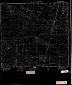
- Description:
- 1941
- Subject:
- Topical Subject: Soviet Union, Topical Subject: Maps, and Geographic Subject: Solodniki
- Publisher:
- Генеральный штаб Красной Армии
- Language:
- Russian
- Date Created:
- 1942
- Identifier:
- VAC9619-003438
- Genre:
- Military Maps and Topographic Maps
- Geographic Location:
- Coordinates: 48.333, 45, 48.667, 45.5
- Related URL:
- Download GeoTIFF: https://drive.google.com/file/d/1a5TQnKjgcqg2QHo-YuNpfeESpk4HhggC/view?usp=sharing and Catalog URL: https://iucat.iu.edu/catalog/5020129
- Abstract:
- Modern area represented: Solodniki, Astrakhan oblast, Russia
- Call Number:
- G7000 s100 .S7 sheet M-38-127
- Caption:
- Для служебного пользования
- City:
- Солодники (Solodniki)
- Copyright Holder:
- No Copyright - United States
- Country:
- СССР (USSR)
- State/Province:
- РСФСР (RSFSR) and Сталинградская область (Stalingrad oblast)
- Physical Description:
- Scale: 1:100,000
- Persistent URL:
- http://purl.dlib.indiana.edu/iudl/images/VAC9619/VAC9619-003438
- Provenance:
- DMA Topographic Center, Army Map Service Library, OMAHA, Atlasblatt
-
- Description:
- 1928
- Subject:
- Topical Subject: Soviet Union, Geographic Subject: Zhitkur, and Topical Subject: Maps
- Publisher:
- Генеральный штаб Красной Армии
- Language:
- Russian
- Date Created:
- 1942
- Identifier:
- VAC9619-003432
- Genre:
- Topographic Maps and Military Maps
- Geographic Location:
- Coordinates: 48.667, 46, 49, 46.5
- Related URL:
- Download GeoTIFF: https://drive.google.com/file/d/10XXUwJCtHnwqXdw2f29tipW879A-nsOm/view?usp=sharing and Catalog URL: https://iucat.iu.edu/catalog/5020129
- Abstract:
- Modern area represented: Zhitkur, Volgograd oblast, Russia
- Call Number:
- G7000 s100 .S7 sheet M-38-117
- Caption:
- Для служебного пользования
- City:
- Житкур (Zhitkur)
- Copyright Holder:
- No Copyright - United States
- Country:
- СССР (USSR)
- State/Province:
- Сталинградская область (Stalingrad oblast) and РСФСР (RSFSR)
- Physical Description:
- Scale: 1:100,000
- Persistent URL:
- http://purl.dlib.indiana.edu/iudl/images/VAC9619/VAC9619-003432
- Provenance:
- DMA Topographic Center, Army Map Service Library, OMAHA, Library of Congress Geography & Map Division
-
- Description:
- 1941
- Subject:
- Topical Subject: Maps, Geographic Subject: Zimnyatskiy, and Topical Subject: Soviet Union
- Publisher:
- Генеральный штаб Красной Армии
- Language:
- Russian
- Date Created:
- 1942
- Identifier:
- VAC9619-003412
- Genre:
- Military Maps and Topographic Maps
- Geographic Location:
- Coordinates: 49.667, 42.5, 50, 43
- Related URL:
- Catalog URL: https://iucat.iu.edu/catalog/5020129 and Download GeoTIFF: https://drive.google.com/file/d/1q_AeD7k13JW_DXMeMLlinHDmFTbUx0Xl/view?usp=sharing
- Abstract:
- Modern area represented: Zimnyatskiy, Volgograd oblast, Russia
- Call Number:
- G7000 s100 .S7 sheet M-38-74
- Caption:
- Для служебного пользования
- City:
- Зимняцкий (Zimnyatskiy)
- Copyright Holder:
- No Copyright - United States
- Country:
- СССР (USSR)
- State/Province:
- РСФСР (RSFSR) and Сталинградская область (Stalingrad oblast)
- Physical Description:
- Scale: 1:100,000
- Persistent URL:
- http://purl.dlib.indiana.edu/iudl/images/VAC9619/VAC9619-003412
- Provenance:
- DMA Topographic Center, Army Map Service Library, OMAHA
-
- Description:
- 1940
- Subject:
- Topical Subject: Soviet Union, Topical Subject: Maps, and Geographic Subject: Lagan
- Publisher:
- Генеральный штаб Красной Армии
- Language:
- Russian
- Date Created:
- 1942
- Identifier:
- VAC9619-002597
- Genre:
- Military Maps and Topographic Maps
- Geographic Location:
- Coordinates: 45.333, 47, 45.667, 47.5
- Related URL:
- Catalog URL: https://iucat.iu.edu/catalog/5020129 and Download GeoTIFF: https://drive.google.com/file/d/118xqIxVJbCLMYzPknJMFF-ICTqV1twyN/view?usp=sharing
- Abstract:
- Modern area represented: Lagan, Kalmykiya Republic, Russia
- Call Number:
- G7000 s100 .S7 sheet L-38-95
- Caption:
- Для служебного пользования
- City:
- Лагань (Lagan)
- Copyright Holder:
- No Copyright - United States
- Country:
- СССР (USSR)
- State/Province:
- РСФСР (RSFSR), Сталинградская область (Stalingrad oblast), and Калмыцкая АССР (Kalmyk Autonomous Soviet Socialist Republic)
- Physical Description:
- Scale: 1:100,000
- Persistent URL:
- http://purl.dlib.indiana.edu/iudl/images/VAC9619/VAC9619-002597
- Provenance:
- CIA Map Library
-
- Description:
- 1941
- Subject:
- Topical Subject: Soviet Union, Geographic Subject: Naryn Khuduk, and Topical Subject: Maps
- Publisher:
- Генеральный штаб Красной Армии
- Language:
- Russian
- Date Created:
- 1942
- Identifier:
- VAC9619-002596
- Genre:
- Topographic Maps and Military Maps
- Geographic Location:
- Coordinates: 45.333, 46.5, 45.667, 47
- Related URL:
- Catalog URL: https://iucat.iu.edu/catalog/5020129 and Download GeoTIFF: https://drive.google.com/file/d/1V21zweeUxfPtxEE1eyaHMGOZBg7JZ5Ds/view?usp=sharing
- Abstract:
- Modern area represented: Naryn Khuduk, Kalmykiya Republic, Russia
- Call Number:
- G7000 s100 .S7 sheet L-38-94
- Caption:
- Для служебного пользования
- City:
- Нарын-Худук (Naryn-Khuduk)
- Copyright Holder:
- No Copyright - United States
- Country:
- СССР (USSR)
- State/Province:
- РСФСР (RSFSR) and Калмыцкая АССР (Kalmyk Autonomous Soviet Socialist Republic)
- Physical Description:
- Scale: 1:100,000
- Persistent URL:
- http://purl.dlib.indiana.edu/iudl/images/VAC9619/VAC9619-002596
- Provenance:
- CIA Map Library
-
- Description:
- 1927
- Subject:
- Geographic Subject: Volnoye, Topical Subject: Maps, and Topical Subject: Soviet Union
- Publisher:
- Генеральный штаб Красной Армии
- Language:
- Russian
- Date Created:
- 1942
- Identifier:
- VAC9619-002466
- Genre:
- Topographic Maps and Military Maps
- Geographic Location:
- Coordinates: 47, 47.5, 47.333, 48
- Related URL:
- Download GeoTIFF: https://drive.google.com/file/d/10lzVdWj6d2pKEPp_CLMQO9f-j0kf3aCI/view?usp=sharing and Catalog URL: https://iucat.iu.edu/catalog/5020129
- Abstract:
- Modern area represented: Volnoye, Astrakhan oblast, Russia
- Call Number:
- G7000 s100 .S7 sheet L-38-36
- Caption:
- Для служебного пользования
- City:
- Вольное (Volnoye)
- Copyright Holder:
- No Copyright - United States
- Country:
- СССР (USSR)
- State/Province:
- Сталинградская область (Stalingrad oblast), Калмыцкая АССР (Kalmyk Autonomous Soviet Socialist Republic), and РСФСР (RSFSR)
- Physical Description:
- Scale: 1:100,000
- Persistent URL:
- http://purl.dlib.indiana.edu/iudl/images/VAC9619/VAC9619-002466
- Provenance:
- DMA Topographic Center, Library of Congress G & M Division, OMAHA, Army Map Service Library
-
- Description:
- 1932
- Subject:
- Topical Subject: Maps, Geographic Subject: Sasykoli, and Topical Subject: Soviet Union
- Publisher:
- Генеральный штаб Красной Армии
- Language:
- Russian
- Date Created:
- 1942
- Identifier:
- VAC9619-002459
- Genre:
- Topographic Maps and Military Maps
- Geographic Location:
- Coordinates: 47.333, 46.5, 47.667, 47
- Related URL:
- Download GeoTIFF: https://drive.google.com/file/d/1JiikN-KozMqYqh3w0oTwB3bv7vBmhdyp/view?usp=sharing and Catalog URL: https://iucat.iu.edu/catalog/5020129
- Abstract:
- Modern area represented: Sasykoli, Astrakhan oblast, Russia
- Call Number:
- G7000 s100 .S7 sheet L-38-22
- Caption:
- Для служебного пользования
- City:
- Сасыколи (Sasykoli)
- Copyright Holder:
- No Copyright - United States
- Country:
- СССР (USSR)
- State/Province:
- Сталинградская область (Stalingrad oblast), Калмыцкая АССР (Kalmyk Autonomous Soviet Socialist Republic), and РСФСР (RSFSR)
- Physical Description:
- Scale: 1:100,000
- Persistent URL:
- http://purl.dlib.indiana.edu/iudl/images/VAC9619/VAC9619-002459
- Provenance:
- DMA Topographic Center, Library of Congress G & M Division, OMAHA, Army Map Service Library
-
- Description:
- 1931
- Subject:
- Topical Subject: Maps, Geographic Subject: Vetryanoye, and Topical Subject: Soviet Union
- Publisher:
- Генеральный штаб Красной Армии
- Language:
- Russian
- Date Created:
- 1942
- Identifier:
- VAC9619-002458
- Genre:
- Military Maps and Topographic Maps
- Geographic Location:
- Coordinates: 47.333, 46, 47.667, 46.5
- Related URL:
- Download GeoTIFF: https://drive.google.com/file/d/1X48w3YHEZys9Dj7wnbM5RxlakaMMB6zQ/view?usp=sharing and Catalog URL: https://iucat.iu.edu/catalog/5020129
- Abstract:
- Modern area represented: Vetryanoye, Kalmykiya Republic, Russia
- Call Number:
- G7000 s100 .S7 sheet L-38-21
- Caption:
- Для служебного пользования
- City:
- Онон-Боро (Onon-Boro)
- Copyright Holder:
- No Copyright - United States
- Country:
- СССР (USSR)
- State/Province:
- Сталинградская область (Stalingrad oblast), РСФСР (RSFSR), and Калмыцкая АССР (Kalmyk Autonomous Soviet Socialist Republic)
- Physical Description:
- Scale: 1:100,000
- Persistent URL:
- http://purl.dlib.indiana.edu/iudl/images/VAC9619/VAC9619-002458
- Provenance:
- DMA Topographic Center, Library of Congress G & M Division, OMAHA, Army Map Service Library
-
- Description:
- 1931
- Subject:
- Topical Subject: Soviet Union, Topical Subject: Maps, and Geographic Subject: Barun
- Publisher:
- Генеральный штаб Красной Армии
- Language:
- Russian
- Date Created:
- 1942
- Identifier:
- VAC9619-002457
- Genre:
- Military Maps and Topographic Maps
- Geographic Location:
- Coordinates: 47.333, 45.5, 47.667, 46
- Related URL:
- Download GeoTIFF: https://drive.google.com/file/d/1ZhUnzUsUyv-giIC_768gciWJUl90Aqqu/view?usp=sharing and Catalog URL: https://iucat.iu.edu/catalog/5020129
- Abstract:
- Modern area represented: Barun, Kalmykiya Republic, Russia
- Call Number:
- G7000 s100 .S7 sheet L-38-20
- Caption:
- Для служебного пользования
- City:
- Баруны (Baruny)
- Copyright Holder:
- No Copyright - United States
- Country:
- СССР (USSR)
- State/Province:
- РСФСР (RSFSR), Сталинградская область (Stalingrad oblast), and Калмыцкая АССР (Kalmyk Autonomous Soviet Socialist Republic)
- Physical Description:
- Scale: 1:100,000
- Persistent URL:
- http://purl.dlib.indiana.edu/iudl/images/VAC9619/VAC9619-002457
- Provenance:
- DMA Topographic Center, Army Map Service Library
-
- Description:
- 1927
- Subject:
- Geographic Subject: Obilnoye, Topical Subject: Maps, and Topical Subject: Soviet Union
- Publisher:
- Генеральный штаб Красной Армии
- Language:
- Russian
- Date Created:
- 1942
- Identifier:
- VAC9619-002456
- Genre:
- Topographic Maps and Military Maps
- Geographic Location:
- Coordinates: 47.333, 44, 47.667, 44.5
- Related URL:
- Download GeoTIFF: https://drive.google.com/file/d/1S5dhI1IurWXEFHWp5VQcum31nKu6wUpq/view?usp=sharing and Catalog URL: https://iucat.iu.edu/catalog/5020129
- Abstract:
- Modern area represented: Obilnoye, Kalmykiya Republic, Russia
- Call Number:
- G7000 s100 .S7 sheet L-38-17
- Caption:
- Для служебного пользования
- City:
- Обильное (Obilnoye)
- Copyright Holder:
- No Copyright - United States
- Country:
- СССР (USSR)
- State/Province:
- РСФСР (RSFSR), Ростовская область (Rostov oblast), and Калмыцкая АССР (Kalmyk Autonomous Soviet Socialist Republic)
- Physical Description:
- Scale: 1:100,000
- Persistent URL:
- http://purl.dlib.indiana.edu/iudl/images/VAC9619/VAC9619-002456
- Provenance:
- Army Map Service Library, Library of Congress G & M Division, Geographic Names Branch
-
- Description:
- 1941
- Subject:
- Geographic Subject: Sokrutovka, Topical Subject: Soviet Union, and Topical Subject: Maps
- Publisher:
- Генеральный штаб Красной Армии
- Language:
- Russian
- Date Created:
- 1942
- Identifier:
- VAC9619-002454
- Genre:
- Topographic Maps and Military Maps
- Geographic Location:
- Coordinates: 47.667, 46.5, 48, 47
- Related URL:
- Download GeoTIFF: https://drive.google.com/file/d/100G8k_iYTgKOFTmwMfcqQRH-Wyly7vBf/view?usp=sharing and Catalog URL: https://iucat.iu.edu/catalog/5020129
- Abstract:
- Modern area represented: Sokrutovka, Astrakhan oblast, Russia
- Call Number:
- G7000 s100 .S7 sheet L-38-10
- Caption:
- Для служебного пользования
- City:
- Сокрутовка (Sokrutovka)
- Copyright Holder:
- No Copyright - United States
- Country:
- СССР (USSR)
- State/Province:
- Сталинградская область (Stalingrad oblast) and РСФСР (RSFSR)
- Physical Description:
- Scale: 1:100,000
- Persistent URL:
- http://purl.dlib.indiana.edu/iudl/images/VAC9619/VAC9619-002454
- Provenance:
- DMA Topographic Center, Library of Congress G & M Division, OMAHA, Army Map Service Library
-
- Description:
- 1941
- Subject:
- Geographic Subject: Kalmykiya Republic, Topical Subject: Soviet Union, and Topical Subject: Maps
- Publisher:
- Генеральный штаб Красной Армии
- Language:
- Russian
- Date Created:
- 1942
- Identifier:
- VAC9619-002453
- Genre:
- Topographic Maps and Military Maps
- Geographic Location:
- Coordinates: 47.667, 45.5, 48, 46
- Related URL:
- Download GeoTIFF: https://drive.google.com/file/d/1tC44O7PXp2dybU_CL-7iJpMCxYhm_ds1/view?usp=sharing and Catalog URL: https://iucat.iu.edu/catalog/5020129
- Abstract:
- Modern area represented: Kalmykiya Republic, Russia
- Call Number:
- G7000 s100 .S7 sheet L-38-8
- Caption:
- Для служебного пользования
- City:
- Большой Марлын (Bolshoy Marlyn)
- Copyright Holder:
- No Copyright - United States
- Country:
- СССР (USSR)
- State/Province:
- Калмыцкая АССР (Kalmyk Autonomous Soviet Socialist Republic), РСФСР (RSFSR), and Сталинградская область (Stalingrad oblast)
- Physical Description:
- Scale: 1:100,000
- Persistent URL:
- http://purl.dlib.indiana.edu/iudl/images/VAC9619/VAC9619-002453
- Provenance:
- DMA Topographic Center, Library of Congress G & M Division, OMAHA, Army Map Service Library
-
- Description:
- 1941
- Subject:
- Topical Subject: Soviet Union, Geographic Subject: Gorodovikovo, and Topical Subject: Maps
- Publisher:
- Генеральный штаб Красной Армии
- Language:
- Russian
- Date Created:
- 1942
- Identifier:
- VAC9619-002452
- Genre:
- Military Maps and Topographic Maps
- Geographic Location:
- Coordinates: 47.667, 44.5, 48, 45
- Related URL:
- Catalog URL: https://iucat.iu.edu/catalog/5020129 and Download GeoTIFF: https://drive.google.com/file/d/1dDA3jzXnD2PSo1fZzpklYTdZA1vvWziq/view?usp=sharing
- Abstract:
- Modern area represented: Gorodovikovo, Kalmykiya Republic, Russia
- Call Number:
- G7000 s100 .S7 sheet L-38-6
- Caption:
- Для служебного пользования
- City:
- Тундутово (Tundutovo)
- Copyright Holder:
- No Copyright - United States
- Country:
- СССР (USSR)
- State/Province:
- Калмыцкая АССР (Kalmyk Autonomous Soviet Socialist Republic) and РСФСР (RSFSR)
- Physical Description:
- Scale: 1:100,000
- Persistent URL:
- http://purl.dlib.indiana.edu/iudl/images/VAC9619/VAC9619-002452
- Provenance:
- DMA Topographic Center, Library of Congress G & M Division, OMAHA, Army Map Service Library
-
- Description:
- 1941
- Subject:
- Topical Subject: Soviet Union, Topical Subject: Maps, and Geographic Subject: Umantsevo
- Publisher:
- Генеральный штаб Красной Армии
- Language:
- Russian
- Date Created:
- 1942
- Identifier:
- VAC9619-002451
- Genre:
- Topographic Maps and Military Maps
- Geographic Location:
- Coordinates: 47.667, 44, 48, 44.5
- Related URL:
- Catalog URL: https://iucat.iu.edu/catalog/5020129 and Download GeoTIFF: https://drive.google.com/file/d/16AHmdmiSsoU4TmgAsa6mHpj5HEE1bqje/view?usp=sharing
- Abstract:
- Modern area represented: Umantsevo, Kalmykiya Republic, Russia
- Call Number:
- G7000 s100 .S7 sheet L-38-5
- Caption:
- Для служебного пользования
- City:
- Уманцево (Umantsevo)
- Copyright Holder:
- No Copyright - United States
- Country:
- СССР (USSR)
- State/Province:
- Калмыцкая АССР (Kalmyk Autonomous Soviet Socialist Republic), РСФСР (RSFSR), and Сталинградская область (Stalingrad oblast)
- Physical Description:
- Scale: 1:100,000
- Persistent URL:
- http://purl.dlib.indiana.edu/iudl/images/VAC9619/VAC9619-002451
- Provenance:
- DMA Topographic Center, Heeresplankammer Auslandskartenarchiv, OMAHA, Army Map Service Library, Library of Congress G & M Division
-
- Description:
- 1905
- Subject:
- Topical Subject: Soviet Union, Topical Subject: Maps, and Geographic Subject: Samurskaya
- Publisher:
- Генеральный штаб Красной Армии
- Language:
- Russian
- Date Created:
- 1942
- Identifier:
- VAC9619-002441
- Genre:
- Military Maps and Topographic Maps
- Geographic Location:
- Coordinates: 44, 39.5, 44.333, 40
- Related URL:
- Catalog URL: https://iucat.iu.edu/catalog/5020129 and Download GeoTIFF: https://drive.google.com/file/d/1b7UdBwg6eM3eqXsa4eMiC18jIGU6KjoG/view?usp=sharing
- Abstract:
- Modern area represented: Samurskaya, Russia
- Call Number:
- G7000 s100 .S7 sheet L-37-140
- Caption:
- Для служебного пользования
- City:
- Самурская (Samurskaya)
- Copyright Holder:
- No Copyright - United States
- Country:
- СССР (USSR)
- State/Province:
- Краснодарский край (Krasnodar kray) and РСФСР (RSFSR)
- Physical Description:
- Scale: 1:100,000
- Persistent URL:
- http://purl.dlib.indiana.edu/iudl/images/VAC9619/VAC9619-002441
- Provenance:
- DMA Topographic Center, Library of Congress G & M Division, OMAHA, Army Map Service Library
-
- Description:
- 1901
- Subject:
- Geographic Subject: Oguzer, Topical Subject: Soviet Union, and Topical Subject: Maps
- Publisher:
- Генеральный штаб Красной Армии
- Language:
- Russian
- Date Created:
- 1942
- Identifier:
- VAC9619-002251
- Genre:
- Topographic Maps and Military Maps
- Geographic Location:
- Coordinates: 44, 47, 44.3333, 47.5
- Related URL:
- Catalog URL: https://iucat.iu.edu/catalog/5020129 and Download GeoTIFF: https://drive.google.com/file/d/1moC2ogiz5WV2pNVSzg7uRFtGt12SLQWr/view?usp=sharing
- Abstract:
- Modern area represented: Oguzer, Dagestan, Russia
- Call Number:
- G7000 s100 .S7 sheet L-38-143
- Caption:
- Для служебного пользования
- City:
- Огузер (Oguzer)
- Copyright Holder:
- No Copyright - United States
- Country:
- СССР (USSR)
- State/Province:
- Кизлярский округ (Kizlyar district), РСФСР (RSFSR), and Орджоникидзевский край (Ordzhonikidze kray)
- Physical Description:
- Scale: 1:100,000
- Persistent URL:
- http://purl.dlib.indiana.edu/iudl/images/VAC9619/VAC9619-002251
- Provenance:
- CIA Map Library
-

- Description:
- 1935
- Subject:
- Topical Subject: Soviet Union, Geographic Subject: Dagestan, Topical Subject: Maps, and Geographic Subject: Chubutla
- Publisher:
- Генеральный штаб Красной Армии
- Language:
- Russian
- Date Created:
- 1942
- Identifier:
- VAC9619-002249
- Genre:
- Topographic Maps and Military Maps
- Geographic Location:
- Coordinates: 44, 46, 44.3333, 46.5
- Related URL:
- Catalog URL: https://iucat.iu.edu/catalog/5020129 and Download GeoTIFF: https://drive.google.com/file/d/1CtOJbTsOR2cKivui8A9rZyUndxVZuweF/view?usp=sharing
- Abstract:
- Modern area represented: Чубутла (Chubutla), Dagestan, Russia
- Call Number:
- G7000 s100 .S7 sheet L-38-141
- Caption:
- Для cлужебного пользования
- City:
- Аул-Чубутла (Aul-Chubutla)
- Copyright Holder:
- No Copyright - United States
- Country:
- СССР (USSR)
- State/Province:
- Кизлярский округ (Kizlyar district), РСФСР (RSFSR), and Орджоникидзевский край (Ordzhonikidze kray)
- Physical Description:
- Scale: 1:100,000
- Persistent URL:
- http://purl.dlib.indiana.edu/iudl/images/VAC9619/VAC9619-002249
- Provenance:
- DMA Topographic Center, Army Map Service Library
-
- Description:
- 1935
- Subject:
- Topical Subject: Soviet Union, Topical Subject: Maps, Geographic Subject: Chubutla, and Geographic Subject: Dagestan
- Publisher:
- Генеральный штаб Красной Армии
- Language:
- Russian
- Date Created:
- 1942
- Identifier:
- VAC9619-002248
- Genre:
- Topographic Maps and Military Maps
- Geographic Location:
- Coordinates: 44, 46, 44.3333, 46.5
- Related URL:
- Catalog URL: https://iucat.iu.edu/catalog/5020129 and Download GeoTIFF: https://drive.google.com/file/d/100QQ5ahXVFMaFSsAM9CrZFGoR3oHOl0l/view?usp=sharing
- Abstract:
- Modern area represented: Чубутла (Chubutla), Dagestan, Russia
- Call Number:
- G7000 s100 .S7 sheet L-38-141
- Caption:
- Для cлужебного пользования
- City:
- Аул-Чубутла (Aul-Chubutla)
- Copyright Holder:
- No Copyright - United States
- Country:
- СССР (USSR)
- State/Province:
- Орджоникидзевский край (Ordzhonikidze kray), Кизлярский округ (Kizlyar district), and РСФСР (RSFSR)
- Physical Description:
- Scale: 1:100,000
- Persistent URL:
- http://purl.dlib.indiana.edu/iudl/images/VAC9619/VAC9619-002248
- Provenance:
- CIA Map Library
-
- Description:
- 1931
- Subject:
- Topical Subject: Soviet Union, Geographic Subject: Terekli-Mekteb, and Topical Subject: Maps
- Publisher:
- Генеральный штаб Красной Армии
- Language:
- Russian
- Date Created:
- 1942
- Identifier:
- VAC9619-002247
- Genre:
- Military Maps and Topographic Maps
- Geographic Location:
- Coordinates: 44, 45.5, 44.3333, 46
- Related URL:
- Download GeoTIFF: https://drive.google.com/file/d/19JNpI44e2BYE9Zig1yM5b4xvbT7XbCN-/view?usp=sharing and Catalog URL: https://iucat.iu.edu/catalog/5020129
- Abstract:
- Modern area represented: Terekli-Mekteb, Dagestan, Russia
- Call Number:
- G7000 s100 .S7 sheet L-38-140
- Caption:
- Для служебного пользования
- City:
- Терекли Мектеб (Terekli Mekteb)
- Copyright Holder:
- No Copyright - United States
- Country:
- СССР (USSR)
- State/Province:
- Орджоникидзевский край (Ordzhonikidze kray), Кизлярский округ (Kizlyar district), and РСФСР (RSFSR)
- Physical Description:
- Scale: 1:100,000
- Persistent URL:
- http://purl.dlib.indiana.edu/iudl/images/VAC9619/VAC9619-002247
- Provenance:
- CIA Map Library, Library of Congress Geography & Map Division
-
- Description:
- 1928
- Subject:
- Topical Subject: Soviet Union, Topical Subject: Maps, and Geographic Subject: Kayasula
- Publisher:
- Генеральный штаб Красной Армии
- Language:
- Russian
- Date Created:
- 1942
- Identifier:
- VAC9619-002246
- Genre:
- Topographic Maps and Military Maps
- Geographic Location:
- Coordinates: 44, 45, 44.3333, 45.5
- Related URL:
- Catalog URL: https://iucat.iu.edu/catalog/5020129 and Download GeoTIFF: https://drive.google.com/file/d/14F9oDcxiwzltI6-2j2gu5lCbVn5jPTnU/view?usp=sharing
- Abstract:
- Modern area represented: Kayasula, Stavropol kray, Russia
- Call Number:
- G7000 s100 .S7 sheet L-38-139
- Caption:
- Для служебного пользования
- City:
- Каясулу (Kayasulu)
- Copyright Holder:
- No Copyright - United States
- Country:
- СССР (USSR)
- State/Province:
- Орджоникидзевский край (Ordzhonikidze kray), РСФСР (RSFSR), and Кизлярский округ (Kizlyar district)
- Physical Description:
- Scale: 1:100,000
- Persistent URL:
- http://purl.dlib.indiana.edu/iudl/images/VAC9619/VAC9619-002246
- Provenance:
- CIA Map Library, Library of Congress Geography & Map Division
