
Search Constraints
You searched for:
Campus
IUB
Remove constraint Campus: IUB
Frame Number
18
Remove constraint Frame Number: 18
Type
Image
Remove constraint Type: Image
Pages
0-99 pages
Remove constraint Pages: 0-99 pages
Subject
Roads
Remove constraint Subject: Roads
Subject
Shrubs
Remove constraint Subject: Shrubs
Subject
Trees
Remove constraint Subject: Trees
1 - 10 of 10
Search Results
-
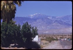
- Description:
- 100 f 8 tl
- Subject:
- Snow, Electric lines, Roads, San Gorgonio Mountain (Calif.), Automobiles, Trees, San Jacinto Peak (Calif.), Mountains, Shrubs, Utility poles, and Palms
- Series:
- 11-59
- Creator:
- Cushman, Charles W., 1896-1972
- Date Created:
- 1959-03-25
- Genre:
- Landscape photographs
- Frame Number:
- 18
- County:
- Riverside
- Abstract:
- Mt. San Gorgonio from road north of Palm Springs
- Call Number:
- P10743
- City:
- Palm Springs
- Country:
- United States
- State/Province:
- California
- Alternate Identifier:
- 1159.18
- Persistent URL:
- http://purl.dlib.indiana.edu/iudl/archives/cushman/P10743
- Holding Location:
- Bloomington - University Archives
Wells Library E460
1320 E 10th St.
Bloomington, IN 47405
Contact at archives@indiana.edu, 812-855-1127
-
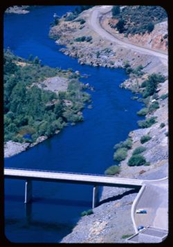
- Description:
- 100 f 5.6 tl
- Subject:
- Rocks, Roads, Automobiles, Trees, Shasta Dam (Calif.), Shrubs, Bridges, Facilities, Rivers, and Sacramento River (Calif.)
- Series:
- 17-55
- Creator:
- Cushman, Charles W., 1896-1972
- Date Created:
- 1955-06-16
- Genre:
- Views
- Frame Number:
- 18
- County:
- Shasta
- Abstract:
- Looking down on small bridge across river below dam
- Call Number:
- P08098
- Country:
- United States
- State/Province:
- California
- Alternate Identifier:
- 1755.18
- Persistent URL:
- http://purl.dlib.indiana.edu/iudl/archives/cushman/P08098
- Holding Location:
- Bloomington - University Archives
Wells Library E460
1320 E 10th St.
Bloomington, IN 47405
Contact at archives@indiana.edu, 812-855-1127
-
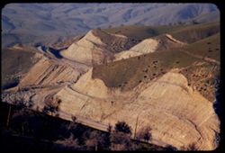
- Description:
- 100 f 4.5 tl
- Subject:
- Rocks, Roads, Tehachapi Mountains (Calif.), Trails & paths, Trees, Mountains, Shrubs, Railroad tracks, Utility poles, and Southern Pacific Railroad Company
- Series:
- 12-55
- Creator:
- Cushman, Charles W., 1896-1972
- Date Created:
- 1955-03-24
- Genre:
- Landscape photographs
- Frame Number:
- 18
- County:
- Kern
- Abstract:
- S P curves, [cut] and tunnel mouth from same vantage point
- Call Number:
- P07914
- City:
- Keene
- Country:
- United States
- State/Province:
- California
- Alternate Identifier:
- 1255.18
- Persistent URL:
- http://purl.dlib.indiana.edu/iudl/archives/cushman/P07914
- Holding Location:
- Bloomington - University Archives
Wells Library E460
1320 E 10th St.
Bloomington, IN 47405
Contact at archives@indiana.edu, 812-855-1127
-
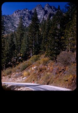
- Description:
- 50 f 8
- Subject:
- Big Springs (Sierra County, Calif.), Roads, People, Shrubs, Walking, Rocks, Sierra Buttes (Calif.), Buttes, Trees, and Pines
- Series:
- 14-54
- Creator:
- Cushman, Charles W., 1896-1972
- Date Created:
- 1954-10-10
- Genre:
- Landscape photographs
- Frame Number:
- 18
- Street Address:
- California State Highway 49
- County:
- Sierra
- Abstract:
- View up toward top of scenic Buttes from along side Big Spring.
- Call Number:
- P07460
- City:
- Sierra City
- Country:
- United States
- State/Province:
- California
- Physical Description:
- masked.
- Alternate Identifier:
- 1454.18
- Persistent URL:
- http://purl.dlib.indiana.edu/iudl/archives/cushman/P07460
- Holding Location:
- Bloomington - University Archives
Wells Library E460
1320 E 10th St.
Bloomington, IN 47405
Contact at archives@indiana.edu, 812-855-1127
-
- Description:
- 50 f 6
- Subject:
- Canyons, Roads, Trees, Mountains, Shrubs, and Oak Creek Canyon (Ariz.)
- Series:
- 16-52
- Creator:
- Cushman, Charles W., 1896-1972
- Date Created:
- 1952-04-12
- Genre:
- Landscape photographs
- Frame Number:
- 18
- Street Address:
- United States Highway 89A
- County:
- Coconino
- Abstract:
- Road down into canyon
- Call Number:
- P06076
- Country:
- United States
- State/Province:
- Arizona
- Alternate Identifier:
- 1652.18
- Persistent URL:
- http://purl.dlib.indiana.edu/iudl/archives/cushman/P06076
- Holding Location:
- Bloomington - University Archives
Wells Library E460
1320 E 10th St.
Bloomington, IN 47405
Contact at archives@indiana.edu, 812-855-1127
-

- Description:
- 50 f 9
- Subject:
- Hills, Roads, Whitney, Mount (Calif.), Mountains, Shrubs, Sierra Nevada (Calif. and Nev.), Trees, Rocks, Fences, Snow, Boulders, and Buildings
- Series:
- 14-52
- Creator:
- Cushman, Charles W., 1896-1972
- Date Created:
- 1952-04-08
- Genre:
- Landscape photographs
- Frame Number:
- 18
- County:
- Inyo
- Abstract:
- Mt. Whitney at dead center.
- Call Number:
- P06002
- Country:
- United States
- State/Province:
- California
- Alternate Identifier:
- 1452.18
- Persistent URL:
- http://purl.dlib.indiana.edu/iudl/archives/cushman/P06002
- Holding Location:
- Bloomington - University Archives
Wells Library E460
1320 E 10th St.
Bloomington, IN 47405
Contact at archives@indiana.edu, 812-855-1127
-
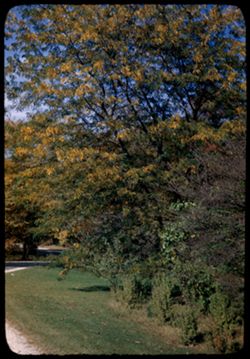
- Description:
- 25 f 10
- Subject:
- Thornhill Building (Wheaton, Ill.), Roads, Shrubs, Trees, Locust trees, Morton Arboretum, Botanical gardens, and Shadows
- Series:
- 11-47
- Creator:
- Cushman, Charles W., 1896-1972
- Date Created:
- 1947-10-16
- Genre:
- Identification photographs
- Frame Number:
- 18
- County:
- Du Page
- Abstract:
- Honey locust -Thorn Hill. Arb W
- Call Number:
- P03840
- City:
- Wheaton
- Country:
- United States
- State/Province:
- Illinois
- Alternate Identifier:
- 1147.18
- Persistent URL:
- http://purl.dlib.indiana.edu/iudl/archives/cushman/P03840
- Holding Location:
- Bloomington - University Archives
Wells Library E460
1320 E 10th St.
Bloomington, IN 47405
Contact at archives@indiana.edu, 812-855-1127
-
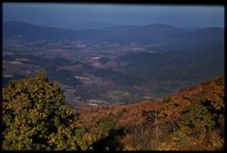
- Subject:
- Roads, Trees, Blue Ridge Mountains, Mountains, Shrubs, and Dwellings
- Series:
- 18-40
- Creator:
- Cushman, Charles W., 1896-1972
- Date Created:
- 1940-10-11
- Genre:
- Landscape photographs
- Frame Number:
- 18
- Street Address:
- Skyline Drive
- Abstract:
- Colors in Blue Ridge from Skyline Drive.
- Call Number:
- P02104
- Country:
- United States
- State/Province:
- Virginia
- Physical Description:
- Image was originally mounted in a glass enclosure. Before digitization, the image was removed and placed in a Wess Plastic, Inc. brand, 2" x 2", pl...
- Alternate Identifier:
- 1840.18
- Persistent URL:
- http://purl.dlib.indiana.edu/iudl/archives/cushman/P02104
- Holding Location:
- Bloomington - University Archives
Wells Library E460
1320 E 10th St.
Bloomington, IN 47405
Contact at archives@indiana.edu, 812-855-1127
-
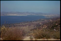
- Subject:
- Wildflowers, Roads, Farms, Trees, Coastlines, Lake Elsinore (Calif.), Croplands, Shrubs, Lakes & ponds, Dwellings, and Mountains
- Series:
- 6-40
- Creator:
- Cushman, Charles W., 1896-1972
- Date Created:
- 1940-06-15
- Genre:
- Landscape photographs
- Frame Number:
- 18
- County:
- Riverside
- Abstract:
- Lake Elsinore, from above.
- Call Number:
- P01855
- Country:
- United States
- State/Province:
- California
- Physical Description:
- Image was originally mounted in a glass enclosure. Before digitization, the image was removed and placed in a Wess Plastic, Inc. brand, 2" x 2", pl...
- Alternate Identifier:
- 640.18
- Persistent URL:
- http://purl.dlib.indiana.edu/iudl/archives/cushman/P01855
- Holding Location:
- Bloomington - University Archives
Wells Library E460
1320 E 10th St.
Bloomington, IN 47405
Contact at archives@indiana.edu, 812-855-1127
-
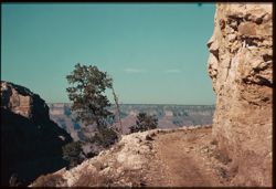
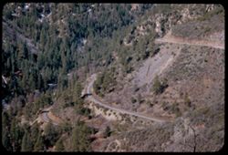
- Subject:
- Canyons, Roads, Shrubs, Trees, Rocks, Trails & paths, and Shadows
- Series:
- 8-39
- Creator:
- Cushman, Charles W., 1896-1972
- Date Created:
- 1939-11-30
- Genre:
- Landscape photographs
- Frame Number:
- 18
- Street Address:
- Burro Road and Bright Angel Trail
- Abstract:
- R-18: Burro road, Bright Angel Trail.
- Call Number:
- P01699
- Country:
- United States
- State/Province:
- Arizona
- Physical Description:
- some dye fading. Image was originally mounted in a glass enclosure. Before digitization, the image was removed and placed in a Wess Plastic, Inc. brand, 2&qu...
- Alternate Identifier:
- 839.18
- Persistent URL:
- http://purl.dlib.indiana.edu/iudl/archives/cushman/P01699
- Holding Location:
- Bloomington - University Archives
Wells Library E460
1320 E 10th St.
Bloomington, IN 47405
Contact at archives@indiana.edu, 812-855-1127